Bridge Statistics for Union Beach, New Jersey (NJ)
Condition, Traffic, Stress, Structural Evaluation, Project Costs
- National Bridge Inventory (NBI) Statistics
- 11Number of bridges
- 43ft / 12.8mTotal length
- $914,000Total costs
- 147,226Total average daily traffic
- 5,297Total average daily truck traffic
- 182,312Total future (year 2039) average daily traffic
- National Bridge Inventory (NBI) Registered Bridges for Union Beach
- No street view available for this location
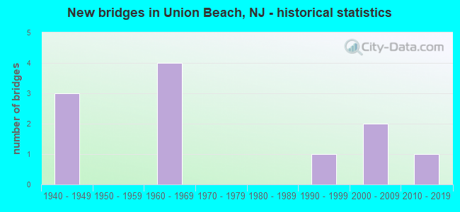
- New bridges - historical statistics
- 31940-1949
- 41960-1969
- 11990-1999
- 22000-2009
- 12010-2019

- Reconstructed bridges - Historical Statistics
- 11950-1959
- 11960-1969
- 01970-1979
- 11980-1989


- Bridge Condition - Deck
- 55.6%Good
- 44.4%Satisfactory

- Bridge Condition - Superstructure
- 33.3%Very good
- 33.3%Good
- 33.3%Satisfactory

- Bridge Condition - Substructure
- 11.1%Very good
- 22.2%Good
- 44.4%Satisfactory
- 22.2%Fair

- Bridge Condition - Channel
- 18.2%Very good
- 45.5%Good
- 36.4%Satisfactory

- Bridge Condition - Culverts
- 50.0%Good
- 50.0%Satisfactory
Find on map >> Show street view
Structure Number: 13000R2, Location: HEAD OF KEYPORT HARBOR (Lat: 40.435139, Lng: -74.207489), Route carried "on" structure: County highway 6, Year Built: 1999, Status: Open, Structure Length: 2.13m (6.99ft), Average Daily Traffic: 7,926 (year 2021), Truck Traffic: 4%, Average Future Daily Traffic: 9,671 (year 2041), Design Load: HS 25 or greater, Features Intersected: LUPPATATONG CREEK
Minimum Vertical Clearance: 30+ m (98+ ft), Kilometerpoint: 1.384, Lanes on structure: 2, Owner: County Highway Agency, Approaching Roadway Width: 10.1m (33.1ft), Material/Design: Prestressed concrete, Design/Construction: Slab, Number Of Spans In Main Unit: 2, Length of Maximum Span: 9.1m (29.9ft), Curb or Sidewalk Widths: Left: 1.7m (5.6ft), Right: 1.7m (5.6ft), Curb-To-Curb Width: 10.1m (33.1ft), Out-to-Out Width: 14.2m (46.6ft)
Condition: Deck: Good, Superstructure: Very good, Substructure: Satisfactory, Channel: Satisfactory, Inventory Rating: 60.8 metric tons, Method Used To Determine Inventory Rating: Load Factor (LF), Structural Evaluation: Equal to present minimum criteria, Deck Geometry: Meets minimum limits, Waterway Adequacy: Equal to present minimum criteria, Approach Roadway Alignment: Equal to present desirable criteria, Designated Inspection Frequency: Every 24 months, Underwater Inspection Frequency: Every 48 months, Inspection Date: May 2021, Underwater Inspection Date: July 2021, Deck Structure Type: Concrete Cast-file-Place, Wearing Surface/Protective System: Wearing Surface: Monolithic Concrete, Deck Protection: Galvanized Reinforcing
Find on map >> Show street view
Structure Number: 13000R6, Location: 0.13 mile E. of Lynn Blvd (Lat: 40.429831, Lng: -74.168739), Route carried "on" structure: City street , Year Built: 1960, Status: Open, Structure Length: 0.70m (2.30ft), Average Daily Traffic: 1,276 (year 2021), Truck Traffic: 1%, Average Future Daily Traffic: 1,557 (year 2041), Design Load: HS 20, Features Intersected: EAST CREEK, Facility Carried by Structure: VIRGINIA AVENUE
Minimum Vertical Clearance: 30+ m (98+ ft), Kilometerpoint: 0.000, Lanes on structure: 2, Owner: County Highway Agency, Approaching Roadway Width: 9.1m (29.9ft), Skew: 1 degrees, Material/Design: Concrete, Design/Construction: Culvert, Number Of Spans In Main Unit: 2, Length of Maximum Span: 3.0m (9.8ft), Curb or Sidewalk Widths: Left: 1.2m (3.9ft), Right: 1.2m (3.9ft), Curb-To-Curb Width: 9.1m (29.9ft), Out-to-Out Width: 15.2m (49.9ft)
Condition: Channel: Good, Culverts: Good, Operating Rating: 46.3 metric tons, Method Used To Determine Operating Rating: Load Factor (LF), Inventory Rating: 27.2 metric tons, Method Used To Determine Inventory Rating: Load Factor (LF), Structural Evaluation: Equal to present minimum criteria, Deck Geometry: Somewhat better than minimum adequacy, Waterway Adequacy: Superior to present desirable criteria, Approach Roadway Alignment: Equal to present desirable criteria, Designated Inspection Frequency: Every 24 months, Inspection Date: May 2021, Deck Structure Type: Concrete Cast-file-Place, Wearing Surface/Protective System: Wearing Surface: Bituminous
Find on map >> Show street view
Structure Number: 13000R7, Location: BOROUGH OF UNION BEACH (Lat: 40.447261, Lng: -74.166539), Route carried "on" structure: County highway 39, Year Built: 2008, Status: Open, Structure Length: 1.13m (3.71ft), Average Daily Traffic: 4,381 (year 2021), Truck Traffic: 3%, Average Future Daily Traffic: 5,346 (year 2041), Design Load: HS 25 or greater, Features Intersected: FLAT CREEK, Facility Carried by Structure: UNION AVENUE
Minimum Vertical Clearance: 30+ m (98+ ft), Kilometerpoint: 2.511, Lanes on structure: 2, Owner: County Highway Agency, Approaching Roadway Width: 9.8m (32.2ft), Material/Design: Prestressed concrete, Design/Construction: Slab, Number Of Spans In Main Unit: 1, Length of Maximum Span: 9.8m (32.2ft), Curb or Sidewalk Widths: Left: 1.7m (5.6ft), Right: 1.7m (5.6ft), Curb-To-Curb Width: 10.7m (35.1ft), Out-to-Out Width: 14.9m (48.9ft)
Condition: Deck: Good, Superstructure: Very good, Substructure: Good, Channel: Good, Inventory Rating: 60.8 metric tons, Method Used To Determine Inventory Rating: Load Factor (LF), Structural Evaluation: Better than present minimum criteria, Deck Geometry: Somewhat better than minimum adequacy, Waterway Adequacy: Somewhat better than minimum adequacy, Approach Roadway Alignment: Equal to present desirable criteria, Designated Inspection Frequency: Every 24 months, Underwater Inspection Frequency: Every 48 months, Inspection Date: May 2021, Underwater Inspection Date: May 2021, Deck Structure Type: Concrete Cast-file-Place, Wearing Surface/Protective System: Wearing Surface: Monolithic Concrete, Deck Protection: Galvanized Reinforcing
Find on map >> Show street view
Structure Number: 1300R17, Location: 0.1 MILES SOUTH OF CR 516 (Lat: 40.426389, Lng: -74.178600), Route carried "on" structure: Other road , Year Built: 1967, Status: Open, Structure Length: 0.91m (2.99ft), Average Daily Traffic: 5,178 (year 2021), Truck Traffic: 3%, Average Future Daily Traffic: 6,319 (year 2039), Features Intersected: BRANCH OF FLAT CREEK, Facility Carried by Structure: POOLE AVENUE
Minimum Vertical Clearance: 30+ m (98+ ft), Kilometerpoint: 0.000, Lanes on structure: 2, Owner: County Highway Agency, Approaching Roadway Width: 11.9m (39.0ft), Skew: 5 degrees, Material/Design: Concrete, Design/Construction: Slab, Number Of Spans In Main Unit: 1, Length of Maximum Span: 5.2m (17.1ft), Curb or Sidewalk Widths: Left: 1.2m (3.9ft), Right: 1.2m (3.9ft), Curb-To-Curb Width: 12.2m (40.0ft), Out-to-Out Width: 19.3m (63.3ft)
Condition: Deck: Good, Superstructure: Good, Substructure: Satisfactory, Channel: Satisfactory, Operating Rating: 57.2 metric tons, Method Used To Determine Operating Rating: Load Factor (LF), Inventory Rating: 34.5 metric tons, Method Used To Determine Inventory Rating: Load Factor (LF), Structural Evaluation: Equal to present minimum criteria, Deck Geometry: Somewhat better than minimum adequacy, Waterway Adequacy: Better than present minimum criteria, Approach Roadway Alignment: Equal to present desirable criteria, Designated Inspection Frequency: Every 24 months, Inspection Date: May 2021, Deck Structure Type: Concrete Cast-file-Place, Wearing Surface/Protective System: Wearing Surface: Bituminous
Find on map >> Show street view
Structure Number: 1300R22, Location: 0.09 miles west of NJ 36 (Lat: 40.423081, Lng: -74.207589), Route carried "on" structure: City street , Year Built: 1946, Year Reconstructed: 1962, Status: Posted for load, Structure Length: 1.01m (3.31ft), Average Daily Traffic: 11,760 (year 2021), Truck Traffic: 1%, Average Future Daily Traffic: 14,350 (year 2041), Features Intersected: LUPPATATONG CREEK, Facility Carried by Structure: CLARK STREET
Minimum Vertical Clearance: 30+ m (98+ ft), Kilometerpoint: 0.000, Lanes on structure: 2, Owner: County Highway Agency, Approaching Roadway Width: 7.0m (23.0ft), Material/Design: Concrete continuous, Design/Construction: Box Beam or Girders - Multiple, Number Of Spans In Main Unit: 2, Length of Maximum Span: 4.9m (16.1ft), Curb or Sidewalk Widths: Left: 0.2m (0.7ft), Right: 0.2m (0.7ft), Curb-To-Curb Width: 6.9m (22.6ft), Out-to-Out Width: 7.3m (24.0ft)
Condition: Deck: Satisfactory, Superstructure: Satisfactory, Substructure: Fair, Channel: Satisfactory, Operating Rating: 33.6 metric tons, Method Used To Determine Operating Rating: Load Factor (LF), Inventory Rating: 20.0 metric tons, Method Used To Determine Inventory Rating: Load Factor (LF), Structural Evaluation: Somewhat better than minimum adequacy, Deck Geometry: High priority of replacement, Waterway Adequacy: Equal to present minimum criteria, Approach Roadway Alignment: Equal to present minimum criteria, Length Of Structure Improvement: 1.01m (3.31ft), Designated Inspection Frequency: Every 24 months, Inspection Date: May 2021, Bridge Improvement Cost: $602,000, Roadway Improvement Cost: $71,000, Total Project Cost: $914,000 ( Estimate for 2021), Deck Structure Type: Concrete Precast Panels, Wearing Surface/Protective System: Wearing Surface: Bituminous
Find on map >> Show street view
Structure Number: 1300R24, Location: 0.37 miles E of Union Ave (Lat: 40.443150, Lng: -74.158519), Route carried "on" structure: City street , Year Built: 2012, Status: Open, Structure Length: 1.28m (4.20ft), Average Daily Traffic: 1,125 (year 2021), Truck Traffic: 1%, Average Future Daily Traffic: 1,373 (year 2041), Design Load: HL 93, Features Intersected: EAST CREEK, Facility Carried by Structure: JERSEY AVENUE
Minimum Vertical Clearance: 30+ m (98+ ft), Kilometerpoint: 0.000, Lanes on structure: 2, Owner: County Highway Agency, Approaching Roadway Width: 9.8m (32.2ft), Navigation Control: Yes ( Vertical Clearance: 0.6m (2.0ft), Horizontal Clearance: 3.0m (9.8ft)), Material/Design: Prestressed concrete, Design/Construction: Box Beam or Girders - Multiple, Number Of Spans In Main Unit: 1, Length of Maximum Span: 11.3m (37.1ft), Curb or Sidewalk Widths: Left: 0.0m, Right: 1.8m (5.9ft), Curb-To-Curb Width: 9.8m (32.2ft), Out-to-Out Width: 12.6m (41.3ft)
Condition: Deck: Good, Superstructure: Very good, Substructure: Very good, Channel: Very good, Operating Rating: 89.4 metric tons, Method Used To Determine Operating Rating: Load and Resistance Factor Rating (LRFR) rating reported by rating factor(RF) method using HL-93 loadings, Inventory Rating: 69.0 metric tons, Method Used To Determine Inventory Rating: Load and Resistance Factor Rating (LRFR) rating reported by rating factor(RF) method using HL-93 loadings, Structural Evaluation: Equal to present desirable criteria, Waterway Adequacy: Superior to present desirable criteria, Approach Roadway Alignment: Equal to present desirable criteria, Designated Inspection Frequency: Every 24 months, Inspection Date: May 2021, Deck Structure Type: Concrete Cast-file-Place, Wearing Surface/Protective System: Deck Protection: Galvanized Reinforcing
Find on map >> Show street view
Structure Number: 1300R28, Location: 0.39 miles E of Poole Ave (Lat: 40.440331, Lng: -74.171711), Route carried "on" structure: City street , Year Built: 1949, Year Reconstructed: 1989, Status: Open, Structure Length: 1.01m (3.31ft), Average Daily Traffic: 755 (year 2021), Truck Traffic: 1%, Average Future Daily Traffic: 922 (year 2041), Design Load: HS 20+Mod, Features Intersected: FLAT CREEK, Facility Carried by Structure: MORNINGSIDE AVENUE
Minimum Vertical Clearance: 30+ m (98+ ft), Kilometerpoint: 0.000, Lanes on structure: 2, Owner: County Highway Agency, Maintenance Responsibility: City or Municipal Highway Agency, Approaching Roadway Width: 7.9m (25.9ft), Material/Design: Concrete continuous, Design/Construction: Slab, Number Of Spans In Main Unit: 2, Length of Maximum Span: 4.6m (15.1ft), Curb or Sidewalk Widths: Left: 1.8m (5.9ft), Right: 1.8m (5.9ft), Curb-To-Curb Width: 7.9m (25.9ft), Out-to-Out Width: 11.6m (38.1ft)
Condition: Deck: Good, Superstructure: Good, Substructure: Satisfactory, Channel: Satisfactory, Operating Rating: 63.5 metric tons, Method Used To Determine Operating Rating: Load Factor (LF), Inventory Rating: 38.1 metric tons, Method Used To Determine Inventory Rating: Load Factor (LF), Structural Evaluation: Equal to present minimum criteria, Deck Geometry: Somewhat better than minimum adequacy, Waterway Adequacy: Equal to present minimum criteria, Approach Roadway Alignment: Equal to present minimum criteria, Designated Inspection Frequency: Every 24 months, Inspection Date: May 2021, Deck Structure Type: Concrete Cast-file-Place, Wearing Surface/Protective System: Wearing Surface: Monolithic Concrete, Deck Protection: Epoxy Coated Reinforcing
Find on map >> Show street view
Structure Number: 1300R29, Location: 0.16 miles west of CR 39 (Lat: 40.444300, Lng: -74.169200), Route carried "on" structure: City street , Year Built: 1946, Year Reconstructed: 1969, Status: Open, Structure Length: 1.43m (4.69ft), Average Daily Traffic: 1,471 (year 2021), Truck Traffic: 1%, Average Future Daily Traffic: 1,795 (year 2041), Features Intersected: FLAT CREEK, Facility Carried by Structure: PARK AVENUE
Minimum Vertical Clearance: 30+ m (98+ ft), Kilometerpoint: 0.000, Lanes on structure: 2, Owner: County Highway Agency, Approaching Roadway Width: 8.2m (26.9ft), Navigation Control: Yes ( Vertical Clearance: 2.1m (6.9ft), Horizontal Clearance: 4.3m (14.1ft)), Material/Design: Concrete continuous, Design/Construction: Slab, Number Of Spans In Main Unit: 3, Length of Maximum Span: 4.6m (15.1ft), Curb or Sidewalk Widths: Left: 1.7m (5.6ft), Right: 1.7m (5.6ft), Curb-To-Curb Width: 8.2m (26.9ft), Out-to-Out Width: 11.6m (38.1ft)
Condition: Deck: Satisfactory, Superstructure: Satisfactory, Substructure: Fair, Channel: Good, Operating Rating: 63.5 metric tons, Method Used To Determine Operating Rating: Load Factor (LF), Inventory Rating: 38.1 metric tons, Method Used To Determine Inventory Rating: Load Factor (LF), Structural Evaluation: Somewhat better than minimum adequacy, Deck Geometry: Meets minimum limits, Waterway Adequacy: Better than present minimum criteria, Approach Roadway Alignment: Equal to present desirable criteria, Designated Inspection Frequency: Every 24 months, Inspection Date: May 2021, Deck Structure Type: Concrete Cast-file-Place, Wearing Surface/Protective System: Wearing Surface: Bituminous
Find on map >> Show street view
Structure Number: 1315152, Location: 6.0 MI SOUTH OF 36-35 JCT (Lat: 40.422461, Lng: -74.096719), Route carried "on" structure: State highway 36, Year Built: 1965, Status: Open, Structure Length: 1.37m (4.49ft), Average Daily Traffic: 30,230 (year 2020), Truck Traffic: 4%, Average Future Daily Traffic: 36,276 (year 2040), Design Load: HS 20, Features Intersected: COMPTONS CREEK
Minimum Vertical Clearance: 30+ m (98+ ft), Kilometerpoint: 29.515, Lanes on structure: 4, Base Highway Network: Yes, Owner: State Highway Agency, Approaching Roadway Width: 22.6m (74.1ft), Skew: 30 degrees, Material/Design: Prestressed concrete, Design/Construction: Box Beam or Girders - Multiple, Number Of Spans In Main Unit: 1, Length of Maximum Span: 12.8m (42.0ft), Curb or Sidewalk Widths: Left: 1.8m (5.9ft), Right: 1.8m (5.9ft), Curb-To-Curb Width: 22.6m (74.1ft), Out-to-Out Width: 27.6m (90.6ft)
Condition: Deck: Satisfactory, Superstructure: Good, Substructure: Good, Channel: Good, Operating Rating: 50.8 metric tons, Method Used To Determine Operating Rating: Load Factor (LF), Inventory Rating: 30.8 metric tons, Method Used To Determine Inventory Rating: Load Factor (LF), Structural Evaluation: Better than present minimum criteria, Deck Geometry: Superior to present desirable criteria, Waterway Adequacy: Equal to present minimum criteria, Approach Roadway Alignment: Equal to present desirable criteria, Designated Inspection Frequency: Every 24 months, Inspection Date: August 2020, Deck Structure Type: Concrete Cast-file-Place, Wearing Surface/Protective System: Wearing Surface: Bituminous
Find on map >> Show street view
Structure Number: 1315156, Location: 2.3 MI E OF NJ 35 JCT (Lat: 40.438011, Lng: -74.162161), Route carried "on" structure: State highway 36, Year Built: 1964, Status: Open, Structure Length: 0.82m (2.69ft), Average Daily Traffic: 42,079 (year 2020), Truck Traffic: 4%, Average Future Daily Traffic: 51,345 (year 2040), Design Load: H 20, Features Intersected: EAST CREEK
Minimum Vertical Clearance: 30.45m (99.90ft), Kilometerpoint: 35.534, Lanes on structure: 4, Base Highway Network: Yes, Owner: State Highway Agency, Approaching Roadway Width: 22.6m (74.1ft), Skew: 30 degrees, Material/Design: Concrete, Design/Construction: Slab, Number Of Spans In Main Unit: 1, Length of Maximum Span: 8.2m (26.9ft), Curb or Sidewalk Widths: Left: 1.8m (5.9ft), Right: 1.2m (3.9ft), Curb-To-Curb Width: 23.5m (77.1ft), Out-to-Out Width: 28.5m (93.5ft)
Condition: Deck: Satisfactory, Superstructure: Satisfactory, Substructure: Satisfactory, Channel: Good, Operating Rating: 74.4 metric tons, Method Used To Determine Operating Rating: Load Factor (LF), Inventory Rating: 44.5 metric tons, Method Used To Determine Inventory Rating: Load Factor (LF), Structural Evaluation: Equal to present minimum criteria, Deck Geometry: Superior to present desirable criteria, Waterway Adequacy: Equal to present minimum criteria, Approach Roadway Alignment: Equal to present desirable criteria, Designated Inspection Frequency: Every 24 months, Inspection Date: March 2020, Deck Structure Type: Concrete Cast-file-Place, Wearing Surface/Protective System: Wearing Surface: Bituminous, Membrane: Other
Find on map >> Show street view
Structure Number: 1315157, Location: 1.8 MI EAST OF RT 35 JCT (Lat: 40.437419, Lng: -74.172231), Route carried "on" structure: State highway 36, Year Built: 2009, Status: Open, Structure Length: 1.01m (3.31ft), Average Daily Traffic: 41,045 (year 2021), Truck Traffic: 4%, Average Future Daily Traffic: 53,358 (year 2041), Design Load: HS 25 or greater, Features Intersected: FLAT CREEK
Minimum Vertical Clearance: 30+ m (98+ ft), Kilometerpoint: 36.387, Lanes on structure: 6, Base Highway Network: Yes, Owner: State Highway Agency, Approaching Roadway Width: 26.2m (86.0ft), Skew: 30 degrees, Material/Design: Concrete, Design/Construction: Culvert, Number Of Spans In Main Unit: 1, Length of Maximum Span: 9.1m (29.9ft), Curb or Sidewalk Widths: Left: 3.4m (11.2ft), Right: 1.8m (5.9ft), Curb-To-Curb Width: 26.2m (86.0ft), Out-to-Out Width: 32.0m (105.0ft)
Condition: Channel: Very good, Culverts: Satisfactory, Operating Rating: 41.1 metric tons, Method Used To Determine Operating Rating: Load and Resistance Factor Rating (LRFR) rating reported by rating factor(RF) method using HL-93 loadings, Inventory Rating: 31.8 metric tons, Method Used To Determine Inventory Rating: Load and Resistance Factor Rating (LRFR) rating reported by rating factor(RF) method using HL-93 loadings, Structural Evaluation: Equal to present minimum criteria, Deck Geometry: Equal to present minimum criteria, Waterway Adequacy: Equal to present minimum criteria, Approach Roadway Alignment: Equal to present desirable criteria, Designated Inspection Frequency: Every 24 months, Inspection Date: March 2021, Wearing Surface/Protective System: Wearing Surface: Bituminous