Bridge Statistics for Union Gap, Washington (WA)
Condition, Traffic, Stress, Structural Evaluation, Project Costs
- National Bridge Inventory (NBI) Statistics
- 32Number of bridges
- 679ft / 207mTotal length
- $94,943,000Total costs
- 304,792Total average daily traffic
- 42,279Total average daily truck traffic
- National Bridge Inventory (NBI) Registered Bridges for Union Gap
- No street view available for this location
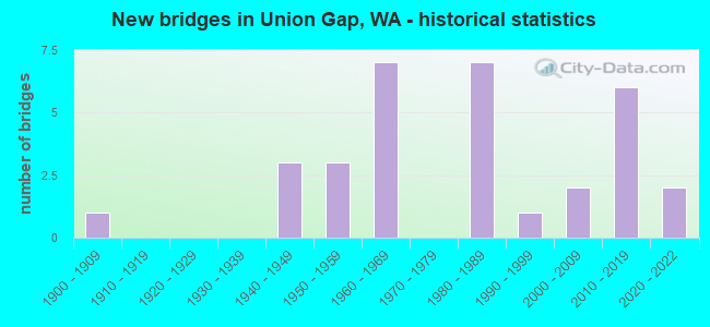
- New bridges - historical statistics
- 11900-1909
- 31940-1949
- 31950-1959
- 71960-1969
- 71980-1989
- 11990-1999
- 22000-2009
- 62010-2019
- 22020-2022
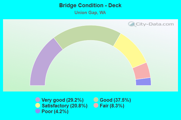
- Bridge Condition - Deck
- 29.2%Very good
- 37.5%Good
- 20.8%Satisfactory
- 8.3%Fair
- 4.2%Poor
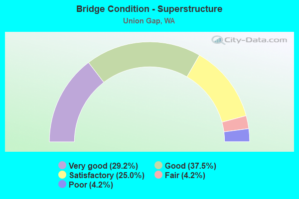
- Bridge Condition - Superstructure
- 29.2%Very good
- 37.5%Good
- 25.0%Satisfactory
- 4.2%Fair
- 4.2%Poor
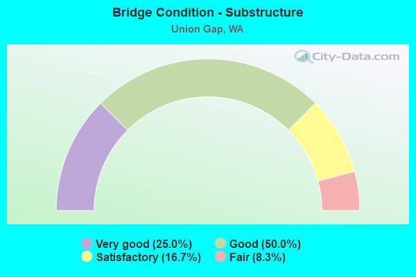
- Bridge Condition - Substructure
- 25.0%Very good
- 50.0%Good
- 16.7%Satisfactory
- 8.3%Fair
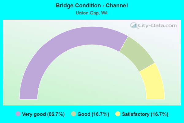
- Bridge Condition - Channel
- 66.7%Very good
- 16.7%Good
- 16.7%Satisfactory
Find on map >> Show street view
Structure Number: 2661A, Location: 14.5 N JCT SR 22 (Lat: 46.537003, Lng: -120.475172), Route carried "on" structure: County highway 97, Year Built: 1941, Status: Open, Structure Length: 4.75m (15.58ft), Average Daily Traffic: 8,981 (year 2012), Truck Traffic: 7%, Average Future Daily Traffic: 13,292 (year 2036), Design Load: H 15, Features Intersected: AHTANUM CREEK
Minimum Vertical Clearance: 30+ m (98+ ft), Kilometerpoint: 0.724, Lanes on structure: 2, Base Highway Network: Yes, Owner: State Highway Agency, Approaching Roadway Width: 9.8m (32.2ft), Skew: 2 degrees, Material/Design: Concrete continuous, Design/Construction: Tee Beam, Number Of Spans In Main Unit: 3, Length of Maximum Span: 20.1m (65.9ft), Curb or Sidewalk Widths: Left: 0.0m, Right: 0.9m (3.0ft), Curb-To-Curb Width: 7.9m (25.9ft), Out-to-Out Width: 9.8m (32.2ft)
Condition: Deck: Satisfactory, Superstructure: Good, Substructure: Good, Channel: Very good, Operating Rating: 23.7 metric tons, Method Used To Determine Operating Rating: Load and Resistance Factor Rating (LRFR) rating reported by rating factor(RF) method using HL-93 loadings, Inventory Rating: 18.1 metric tons, Method Used To Determine Inventory Rating: Load and Resistance Factor Rating (LRFR) rating reported by rating factor(RF) method using HL-93 loadings, Structural Evaluation: Meets minimum limits, Deck Geometry: High priority of replacement, Waterway Adequacy: Equal to present desirable criteria, Approach Roadway Alignment: Equal to present desirable criteria, Length Of Structure Improvement: 4.75m (15.58ft), Designated Inspection Frequency: Every 48 months, Inspection Date: April 2018, Bridge Improvement Cost: $1,061,000, Roadway Improvement Cost: $212,000, Total Project Cost: $2,122,000 ( Estimate for 2014), Deck Structure Type: Concrete Cast-file-Place, Wearing Surface/Protective System: Wearing Surface: Bituminous
Find on map >> Show street view
Structure Number: 2661B, Location: 14.7 N JCT SR22 (Lat: 46.539806, Lng: -120.476222), Route carried "on" structure: City street 97, Year Built: 1941, Status: Posted for load, Structure Length: 21.34m (70.01ft), Average Daily Traffic: 8,981 (year 2012), Truck Traffic: 7%, Average Future Daily Traffic: 13,292 (year 2036), Design Load: H 15, Features Intersected: NP RY & RAMP
Minimum Vertical Clearance: 30+ m (98+ ft), Kilometerpoint: 0.225, Lanes on structure: 2, Lanes under structure: 1, Base Highway Network: Yes, Owner: State Highway Agency, Approaching Roadway Width: 12.2m (40.0ft), Material/Design: Concrete continuous, Design/Construction: Tee Beam, Number Of Spans In Main Unit: 12, Length of Maximum Span: 21.6m (70.9ft), Curb or Sidewalk Widths: Left: 0.0m, Right: 0.9m (3.0ft), Curb-To-Curb Width: 7.9m (25.9ft), Out-to-Out Width: 9.8m (32.2ft)
Condition: Deck: Good, Superstructure: Good, Substructure: Satisfactory, Operating Rating: 20.4 metric tons, Method Used To Determine Operating Rating: Load and Resistance Factor Rating (LRFR) rating reported by rating factor(RF) method using HL-93 loadings, Inventory Rating: 15.9 metric tons, Method Used To Determine Inventory Rating: Load and Resistance Factor Rating (LRFR) rating reported by rating factor(RF) method using HL-93 loadings, Structural Evaluation: High priority of corrective action, Deck Geometry: High priority of corrective action, Underclear: Equal to present minimum criteria, Approach Roadway Alignment: Equal to present desirable criteria, Bridge Posting: Required (Relationship of Operating Rating to Maximum Legal Load: 10.0 - 19.9% below), Length Of Structure Improvement: 21.34m (70.01ft), Designated Inspection Frequency: Every 24 months, Inspection Date: May 2020, Bridge Improvement Cost: $5,880,000, Roadway Improvement Cost: $1,176,000, Total Project Cost: $11,760,000 ( Estimate for 2014), Deck Structure Type: Concrete Cast-file-Place, Wearing Surface/Protective System: Wearing Surface: Bituminous
Find on map >> Show street view
Structure Number: 2661C, Location: 15.0 N JCT SR 22 (Lat: 46.543528, Lng: -120.476056), Route carried "on" structure: City street 97, Year Built: 1941, Status: Posted for load, Structure Length: 0.70m (2.30ft), Average Daily Traffic: 11,558 (year 2012), Truck Traffic: 7%, Average Future Daily Traffic: 17,106 (year 2036), Design Load: H 15, Features Intersected: WIDE HOLLOW CREEK, Facility Carried by Structure: MAIN ST UNION GAP
Minimum Vertical Clearance: 30+ m (98+ ft), Kilometerpoint: 0.001, Lanes on structure: 4, Base Highway Network: Yes, Owner: State Highway Agency, Approaching Roadway Width: 20.1m (65.9ft), Material/Design: Concrete, Design/Construction: Slab, Number Of Spans In Main Unit: 1, Length of Maximum Span: 6.7m (22.0ft), Curb-To-Curb Width: 18.1m (59.4ft), Out-to-Out Width: 19.6m (64.3ft)
Condition: Deck: Good, Superstructure: Good, Substructure: Good, Channel: Very good, Operating Rating: 32.1 metric tons, Method Used To Determine Operating Rating: Load and Resistance Factor Rating (LRFR) rating reported by rating factor(RF) method using HL-93 loadings, Inventory Rating: 24.6 metric tons, Method Used To Determine Inventory Rating: Load and Resistance Factor Rating (LRFR) rating reported by rating factor(RF) method using HL-93 loadings, Structural Evaluation: Equal to present minimum criteria, Deck Geometry: Somewhat better than minimum adequacy, Waterway Adequacy: Equal to present minimum criteria, Approach Roadway Alignment: Equal to present desirable criteria, Bridge Posting: Required (Relationship of Operating Rating to Maximum Legal Load: 0.1 - 9.9% below), Length Of Structure Improvement: 0.70m (2.30ft), Designated Inspection Frequency: Every 24 months, Inspection Date: May 2020, Bridge Improvement Cost: $313,000, Roadway Improvement Cost: $63,000, Total Project Cost: $626,000 ( Estimate for 2014), Deck Structure Type: Concrete Cast-file-Place, Wearing Surface/Protective System: Wearing Surface: Bituminous
Find on map >> Show street view
Structure Number: 7949A, Location: 0.2 E JCT US 97 (Lat: 46.536389, Lng: -120.471028), Route carried "on" structure: Ramp Interstate 82, Year Built: 1967, Status: Open, Structure Length: 10.12m (33.20ft), Average Daily Traffic: 2,118 (year 2019), Truck Traffic: 13%, Average Future Daily Traffic: 2,778 (year 2039), Design Load: HS 20, Features Intersected: I-82, Facility Carried by Structure: W-N RAMP
Minimum Vertical Clearance: 30+ m (98+ ft), Kilometerpoint: 0.579, Lanes on structure: 1, Lanes under structure: 4, Owner: State Highway Agency, Approaching Roadway Width: 7.3m (24.0ft), Material/Design: Concrete continuous, Design/Construction: Box Beam or Girders - Multiple, Number Of Spans In Main Unit: 4, Length of Maximum Span: 28.3m (92.8ft), Curb or Sidewalk Widths: Left: 0.5m (1.6ft), Right: 0.5m (1.6ft), Curb-To-Curb Width: 6.4m (21.0ft), Out-to-Out Width: 7.9m (25.9ft)
Condition: Deck: Very good, Superstructure: Good, Substructure: Satisfactory, Operating Rating: 38.2 metric tons, Method Used To Determine Operating Rating: Load and Resistance Factor Rating (LRFR) rating reported by rating factor(RF) method using HL-93 loadings, Inventory Rating: 29.5 metric tons, Method Used To Determine Inventory Rating: Load and Resistance Factor Rating (LRFR) rating reported by rating factor(RF) method using HL-93 loadings, Structural Evaluation: Equal to present minimum criteria, Deck Geometry: Somewhat better than minimum adequacy, Underclear: Somewhat better than minimum adequacy, Approach Roadway Alignment: Equal to present minimum criteria, Length Of Structure Improvement: 10.12m (33.20ft), Designated Inspection Frequency: Every 24 months, Inspection Date: April 2021, Bridge Improvement Cost: $1,726,000, Roadway Improvement Cost: $345,000, Total Project Cost: $3,453,000 ( Estimate for 2014), Deck Structure Type: Concrete Cast-file-Place, Wearing Surface/Protective System: Wearing Surface: Bituminous, Membrane: Preformed Fabric
Find on map >> Show street view
Structure Number: 7949B, Location: 0.6 E JCT US 97 (Lat: 46.531611, Lng: -120.471361), Route carried "on" structure: Interstate 82, Year Built: 1967, Status: Open, Structure Length: 20.60m (67.59ft), Average Daily Traffic: 15,140 (year 2019), Truck Traffic: 15%, Average Future Daily Traffic: 19,863 (year 2039), Design Load: HS 20+Mod, Features Intersected: YAKIMA RIVER
Minimum Vertical Clearance: 30+ m (98+ ft), Kilometerpoint: 61.928, Lanes on structure: 2, Base Highway Network: Yes, Owner: State Highway Agency, Approaching Roadway Width: 11.6m (38.1ft), Material/Design: Concrete continuous, Design/Construction: Box Beam or Girders - Multiple, Number Of Spans In Main Unit: 6, Length of Maximum Span: 37.5m (123.0ft), Curb or Sidewalk Widths: Left: 0.5m (1.6ft), Right: 0.5m (1.6ft), Curb-To-Curb Width: 9.1m (29.9ft), Out-to-Out Width: 10.6m (34.8ft)
Condition: Deck: Good, Superstructure: Satisfactory, Substructure: Good, Channel: Very good, Operating Rating: 51.2 metric tons, Method Used To Determine Operating Rating: Load and Resistance Factor Rating (LRFR) rating reported by rating factor(RF) method using HL-93 loadings, Inventory Rating: 39.5 metric tons, Method Used To Determine Inventory Rating: Load and Resistance Factor Rating (LRFR) rating reported by rating factor(RF) method using HL-93 loadings, Structural Evaluation: Equal to present minimum criteria, Deck Geometry: Meets minimum limits, Waterway Adequacy: Equal to present desirable criteria, Approach Roadway Alignment: Equal to present desirable criteria, Length Of Structure Improvement: 20.60m (67.59ft), Designated Inspection Frequency: Every 24 months, Underwater Inspection Frequency: Every 60 months, Inspection Date: August 2018, Underwater Inspection Date: September 2018, Bridge Improvement Cost: $5,408,000, Roadway Improvement Cost: $1,082,000, Total Project Cost: $10,816,000 ( Estimate for 2014), Deck Structure Type: Concrete Cast-file-Place, Wearing Surface/Protective System: Wearing Surface: Bituminous, Membrane: Preformed Fabric
Find on map >> Show street view
Structure Number: 7949C, Location: 0.6 E JCT US 97 (Lat: 46.531417, Lng: -120.471722), Route carried "on" structure: Interstate 82, Year Built: 1967, Status: Open, Structure Length: 20.60m (67.59ft), Average Daily Traffic: 15,140 (year 2019), Truck Traffic: 15%, Average Future Daily Traffic: 19,863 (year 2039), Design Load: HS 20+Mod, Features Intersected: YAKIMA RIVER
Minimum Vertical Clearance: 30+ m (98+ ft), Kilometerpoint: 61.944, Lanes on structure: 2, Base Highway Network: Yes, Owner: State Highway Agency, Approaching Roadway Width: 11.6m (38.1ft), Material/Design: Concrete continuous, Design/Construction: Box Beam or Girders - Multiple, Number Of Spans In Main Unit: 6, Length of Maximum Span: 37.5m (123.0ft), Curb or Sidewalk Widths: Left: 0.5m (1.6ft), Right: 0.5m (1.6ft), Curb-To-Curb Width: 9.1m (29.9ft), Out-to-Out Width: 10.6m (34.8ft)
Condition: Deck: Satisfactory, Superstructure: Satisfactory, Substructure: Good, Channel: Very good, Operating Rating: 49.9 metric tons, Method Used To Determine Operating Rating: Load and Resistance Factor Rating (LRFR) rating reported by rating factor(RF) method using HL-93 loadings, Inventory Rating: 38.6 metric tons, Method Used To Determine Inventory Rating: Load and Resistance Factor Rating (LRFR) rating reported by rating factor(RF) method using HL-93 loadings, Structural Evaluation: Equal to present minimum criteria, Deck Geometry: Meets minimum limits, Waterway Adequacy: Equal to present desirable criteria, Approach Roadway Alignment: Equal to present desirable criteria, Length Of Structure Improvement: 20.60m (67.59ft), Designated Inspection Frequency: Every 48 months, Underwater Inspection Frequency: Every 60 months, Inspection Date: August 2018, Underwater Inspection Date: September 2018, Bridge Improvement Cost: $5,408,000, Roadway Improvement Cost: $1,082,000, Total Project Cost: $10,816,000 ( Estimate for 2014), Deck Structure Type: Concrete Cast-file-Place, Wearing Surface/Protective System: Wearing Surface: Bituminous, Membrane: Preformed Fabric
Find on map >> Show street view
Structure Number: 11580A, Location: 14.5 N JCT SR 22 (Lat: 46.535944, Lng: -120.474306), Route carried "on" structure: US 97, Year Built: 1981, Status: Open, Structure Length: 40.08m (131.50ft), Average Daily Traffic: 10,999 (year 2019), Truck Traffic: 9%, Average Future Daily Traffic: 14,430 (year 2039), Design Load: HS 20+Mod, Features Intersected: AHTANUM CRK,RR&N-N RAMP
Minimum Vertical Clearance: 30+ m (98+ ft), Kilometerpoint: 122.181, Lanes on structure: 2, Lanes under structure: 3, Base Highway Network: Yes, Owner: State Highway Agency, Approaching Roadway Width: 11.6m (38.1ft), Material/Design: Prestressed concrete continuous, Design/Construction: Box Beam or Girders - Multiple, Number Of Spans In Main Unit: 8, Length of Maximum Span: 52.4m (171.9ft), Curb-To-Curb Width: 11.6m (38.1ft), Out-to-Out Width: 12.6m (41.3ft)
Condition: Deck: Fair, Superstructure: Satisfactory, Substructure: Good, Channel: Very good, Operating Rating: 41.7 metric tons, Method Used To Determine Operating Rating: Load Factor (LF), Inventory Rating: 24.5 metric tons, Method Used To Determine Inventory Rating: Load Factor (LF), Structural Evaluation: Equal to present minimum criteria, Deck Geometry: Equal to present minimum criteria, Underclear: Equal to present minimum criteria, Waterway Adequacy: Equal to present desirable criteria, Approach Roadway Alignment: Equal to present desirable criteria, Length Of Structure Improvement: 40.08m (131.50ft), Designated Inspection Frequency: Every 24 months, Inspection Date: July 2018, Bridge Improvement Cost: $10,520,000, Roadway Improvement Cost: $2,104,000, Total Project Cost: $21,040,000 ( Estimate for 2014), Deck Structure Type: Concrete Cast-file-Place, Wearing Surface/Protective System: Wearing Surface: Monolithic Concrete, Deck Protection: Epoxy Coated Reinforcing
Find on map >> Show street view
Structure Number: 11580B, Location: 14.5 N JCT SR 22 (Lat: 46.536361, Lng: -120.474528), Route carried "on" structure: US 97, Year Built: 1981, Status: Open, Structure Length: 36.76m (120.60ft), Average Daily Traffic: 10,999 (year 2019), Truck Traffic: 9%, Average Future Daily Traffic: 14,430 (year 2039), Design Load: HS 20+Mod, Features Intersected: AHTANUM CRK, RR & ROADS
Minimum Vertical Clearance: 30+ m (98+ ft), Kilometerpoint: 122.230, Lanes on structure: 1, Lanes under structure: 3, Base Highway Network: Yes, Owner: State Highway Agency, Approaching Roadway Width: 7.9m (25.9ft), Material/Design: Prestressed concrete continuous, Design/Construction: Box Beam or Girders - Multiple, Number Of Spans In Main Unit: 7, Length of Maximum Span: 52.4m (171.9ft), Curb-To-Curb Width: 7.9m (25.9ft), Out-to-Out Width: 8.8m (28.9ft)
Condition: Deck: Satisfactory, Superstructure: Satisfactory, Substructure: Satisfactory, Channel: Very good, Operating Rating: 46.3 metric tons, Method Used To Determine Operating Rating: Load Factor (LF), Inventory Rating: 27.2 metric tons, Method Used To Determine Inventory Rating: Load Factor (LF), Structural Evaluation: Equal to present minimum criteria, Deck Geometry: High priority of corrective action, Underclear: Somewhat better than minimum adequacy, Waterway Adequacy: Equal to present desirable criteria, Approach Roadway Alignment: Equal to present desirable criteria, Length Of Structure Improvement: 36.76m (120.60ft), Designated Inspection Frequency: Every 48 months, Inspection Date: July 2018, Bridge Improvement Cost: $6,754,000, Roadway Improvement Cost: $1,351,000, Total Project Cost: $13,507,000 ( Estimate for 2014), Deck Structure Type: Concrete Cast-file-Place, Wearing Surface/Protective System: Wearing Surface: Monolithic Concrete
Find on map >> Show street view
Structure Number: 11580C, Location: 14.9 N JCT SR 22 (Lat: 46.540694, Lng: -120.471278), Route carried "on" structure: US 97, Year Built: 1981, Status: Open, Structure Length: 7.86m (25.79ft), Average Daily Traffic: 10,322 (year 2019), Truck Traffic: 9%, Average Future Daily Traffic: 13,542 (year 2039), Design Load: HS 20+Mod, Features Intersected: I-82
Minimum Vertical Clearance: 30+ m (98+ ft), Kilometerpoint: 122.809, Lanes on structure: 1, Lanes under structure: 4, Base Highway Network: Yes, Owner: State Highway Agency, Approaching Roadway Width: 7.9m (25.9ft), Skew: 3 degrees, Material/Design: Concrete continuous, Design/Construction: Box Beam or Girders - Multiple, Number Of Spans In Main Unit: 2, Length of Maximum Span: 41.1m (134.8ft), Curb-To-Curb Width: 7.9m (25.9ft), Out-to-Out Width: 8.8m (28.9ft)
Condition: Deck: Satisfactory, Superstructure: Good, Substructure: Good, Operating Rating: 89.8 metric tons, Method Used To Determine Operating Rating: Load Factor (LF), Inventory Rating: 53.5 metric tons, Method Used To Determine Inventory Rating: Load Factor (LF), Structural Evaluation: Better than present minimum criteria, Deck Geometry: High priority of corrective action, Underclear: Equal to present minimum criteria, Approach Roadway Alignment: Equal to present desirable criteria, Length Of Structure Improvement: 7.86m (25.79ft), Designated Inspection Frequency: Every 48 months, Inspection Date: April 2018, Bridge Improvement Cost: $1,445,000, Roadway Improvement Cost: $289,000, Total Project Cost: $2,890,000 ( Estimate for 2014), Deck Structure Type: Concrete Cast-file-Place, Wearing Surface/Protective System: Wearing Surface: Monolithic Concrete, Deck Protection: Epoxy Coated Reinforcing
Find on map >> Show street view
Structure Number: 17858A, Location: 1.5 E JCT SR 24 (Lat: 46.563167, Lng: -120.472361), Route carried "on" structure: Interstate 82, Year Built: 2011, Status: Open, Structure Length: 3.87m (12.70ft), Average Daily Traffic: 16,068 (year 2019), Truck Traffic: 12%, Average Future Daily Traffic: 21,081 (year 2039), Design Load: HL 93, Features Intersected: VALLEY MALL BLVD
Minimum Vertical Clearance: 30+ m (98+ ft), Kilometerpoint: 58.403, Lanes on structure: 3, Lanes under structure: 3, Base Highway Network: Yes, Owner: State Highway Agency, Approaching Roadway Width: 17.1m (56.1ft), Material/Design: Prestressed concrete, Design/Construction: Stringer/Multi-beam, Number Of Spans In Main Unit: 1, Length of Maximum Span: 38.7m (127.0ft), Curb-To-Curb Width: 17.1m (56.1ft), Out-to-Out Width: 18.0m (59.1ft)
Condition: Deck: Very good, Superstructure: Very good, Substructure: Very good, Operating Rating: 89.8 metric tons, Method Used To Determine Operating Rating: Load Factor (LF), Inventory Rating: 58.0 metric tons, Method Used To Determine Inventory Rating: Load Factor (LF), Structural Evaluation: Equal to present desirable criteria, Deck Geometry: Equal to present minimum criteria, Underclear: Somewhat better than minimum adequacy, Approach Roadway Alignment: Equal to present desirable criteria, Length Of Structure Improvement: 3.87m (12.70ft), Designated Inspection Frequency: Every 24 months, Inspection Date: July 2021, Bridge Improvement Cost: $1,473,000, Roadway Improvement Cost: $295,000, Total Project Cost: $2,946,000 ( Estimate for 2014), Deck Structure Type: Concrete Cast-file-Place, Wearing Surface/Protective System: Wearing Surface: Monolithic Concrete, Deck Protection: Epoxy Coated Reinforcing
Find on map >> Show street view
Structure Number: 17858B, Location: 1.5 E JCT SR 24 (Lat: 46.563167, Lng: -120.472139), Route carried "on" structure: Interstate 82, Year Built: 2011, Status: Open, Structure Length: 3.87m (12.70ft), Average Daily Traffic: 16,068 (year 2019), Truck Traffic: 12%, Average Future Daily Traffic: 21,081 (year 2039), Design Load: HL 93, Features Intersected: VALLEY MALL BLVD
Minimum Vertical Clearance: 30+ m (98+ ft), Kilometerpoint: 58.403, Lanes on structure: 4, Lanes under structure: 3, Base Highway Network: Yes, Owner: State Highway Agency, Approaching Roadway Width: 21.0m (68.9ft), Material/Design: Prestressed concrete, Design/Construction: Stringer/Multi-beam, Number Of Spans In Main Unit: 1, Length of Maximum Span: 37.2m (122.0ft), Curb-To-Curb Width: 21.1m (69.2ft), Out-to-Out Width: 21.9m (71.9ft)
Condition: Deck: Very good, Superstructure: Very good, Substructure: Very good, Operating Rating: 89.8 metric tons, Method Used To Determine Operating Rating: Load Factor (LF), Inventory Rating: 60.8 metric tons, Method Used To Determine Inventory Rating: Load Factor (LF), Structural Evaluation: Equal to present desirable criteria, Deck Geometry: Better than present minimum criteria, Underclear: Somewhat better than minimum adequacy, Approach Roadway Alignment: Equal to present desirable criteria, Length Of Structure Improvement: 3.87m (12.70ft), Designated Inspection Frequency: Every 24 months, Inspection Date: July 2021, Bridge Improvement Cost: $1,804,000, Roadway Improvement Cost: $361,000, Total Project Cost: $3,607,000 ( Estimate for 2014), Deck Structure Type: Concrete Cast-file-Place, Wearing Surface/Protective System: Wearing Surface: Monolithic Concrete, Deck Protection: Epoxy Coated Reinforcing
Find on map >> Show street view
Structure Number: 19247A, Location: 0.2 E JCT US 97 (Lat: 46.536389, Lng: -120.471028), Route carried "on" structure: Ramp Interstate 82, Year Built: 2020, Status: Open, Structure Length: 7.65m (25.10ft), Average Daily Traffic: 2,129 (year 2016), Truck Traffic: 14%, Average Future Daily Traffic: 2,992 (year 2038), Design Load: HL 93, Features Intersected: I-82, Facility Carried by Structure: S-W RAMP
Minimum Vertical Clearance: 30+ m (98+ ft), Kilometerpoint: 0.001, Lanes on structure: 1, Lanes under structure: 4, Owner: State Highway Agency, Approaching Roadway Width: 7.9m (25.9ft), Skew: 4 degrees, Material/Design: Prestressed concrete continuous, Design/Construction: Stringer/Multi-beam, Number Of Spans In Main Unit: 2, Length of Maximum Span: 38.4m (126.0ft), Curb-To-Curb Width: 7.9m (25.9ft), Out-to-Out Width: 8.8m (28.9ft)
Condition: Deck: Very good, Superstructure: Very good, Substructure: Very good, Operating Rating: 48.3 metric tons, Method Used To Determine Operating Rating: Load and Resistance Factor Rating (LRFR) rating reported by rating factor(RF) method using HL-93 loadings, Inventory Rating: 37.3 metric tons, Method Used To Determine Inventory Rating: Load and Resistance Factor Rating (LRFR) rating reported by rating factor(RF) method using HL-93 loadings, Structural Evaluation: Equal to present desirable criteria, Deck Geometry: Equal to present desirable criteria, Underclear: Equal to present minimum criteria, Approach Roadway Alignment: Equal to present minimum criteria, Length Of Structure Improvement: 7.65m (25.10ft), Designated Inspection Frequency: Every 24 months, Inspection Date: June 2020, Bridge Improvement Cost: $1,406,000, Roadway Improvement Cost: $281,000, Total Project Cost: $2,811,000 ( Estimate for 2014), Deck Structure Type: Concrete Cast-file-Place, Wearing Surface/Protective System: Wearing Surface: Monolithic Concrete, Deck Protection: Epoxy Coated Reinforcing
Find on map >> Show street view
Structure Number: 200033, Location: 0.1 E JCT US 97 (Lat: 46.537889, Lng: -120.471472), Route carried "on" structure: Interstate 82, Year Built: 1900, Status: Open, Structure Length: 0.82m (2.69ft), Average Daily Traffic: 26,178 (year 2019), Truck Traffic: 12%, Average Future Daily Traffic: 34,345 (year 2039), Features Intersected: AHTANUM CREEK
Minimum Vertical Clearance: 30+ m (98+ ft), Kilometerpoint: 61.236, Lanes on structure: 4, Base Highway Network: Yes, Owner: State Highway Agency, Approaching Roadway Width: 23.2m (76.1ft), Skew: 13 degrees, Material/Design: Concrete, Design/Construction: Culvert, Number Of Spans In Main Unit: 2, Length of Maximum Span: 3.7m (12.1ft)
Condition: Channel: Very good, Culverts: Good, Operating Rating: 24.5 metric tons, Method Used To Determine Operating Rating: Load Factor (LF), Inventory Rating: 15.4 metric tons, Method Used To Determine Inventory Rating: Load Factor (LF), Structural Evaluation: High priority of corrective action, Waterway Adequacy: Equal to present desirable criteria, Approach Roadway Alignment: Equal to present desirable criteria, Length Of Structure Improvement: 0.82m (2.69ft), Designated Inspection Frequency: Every 24 months, Underwater Inspection Frequency: Every 24 months, Inspection Date: Febuary 2020, Underwater Inspection Date: Febuary 2020, Bridge Improvement Cost: $421,000, Roadway Improvement Cost: $84,000, Total Project Cost: $842,000 ( Estimate for 2014)
Find on map >> Show street view
Structure Number: 79873, Location: 00.11 N GILBERT RD (Lat: 46.551667, Lng: -120.526667), Route carried "on" structure: County highway 30490, Year Built: 1957, Status: Open, Structure Length: 0.91m (2.99ft), Average Daily Traffic: 1,650 (year 2021), Truck Traffic: 5%, Average Future Daily Traffic: 1,980 (year 2041), Design Load: H 20, Features Intersected: AHTANUM CREEK, Facility Carried by Structure: 16TH AVE.,S.
Minimum Vertical Clearance: 30+ m (98+ ft), Kilometerpoint: 0.001, Lanes on structure: 2, Owner: County Highway Agency, Approaching Roadway Width: 6.7m (22.0ft), Material/Design: Concrete, Design/Construction: Channel Beam, Number Of Spans In Main Unit: 1, Length of Maximum Span: 8.8m (28.9ft), Curb-To-Curb Width: 7.2m (23.6ft), Out-to-Out Width: 7.3m (24.0ft)
Condition: Deck: Good, Superstructure: Good, Substructure: Good, Channel: Good, Operating Rating: 45.4 metric tons, Method Used To Determine Operating Rating: Load Factor (LF), Inventory Rating: 27.2 metric tons, Method Used To Determine Inventory Rating: Load Factor (LF), Structural Evaluation: Equal to present minimum criteria, Deck Geometry: High priority of corrective action, Waterway Adequacy: Equal to present minimum criteria, Approach Roadway Alignment: Equal to present desirable criteria, Length Of Structure Improvement: 1.22m (4.00ft), Designated Inspection Frequency: Every 24 months, Inspection Date: March 2021, Bridge Improvement Cost: $608,000, Roadway Improvement Cost: $122,000, Total Project Cost: $1,216,000 ( Estimate for 2014), Deck Structure Type: Other, Wearing Surface/Protective System: Wearing Surface: Bituminous
Find on map >> Show street view
Structure Number: 81463, Location: 00.47 N MEADOWBROOK (Lat: 46.548333, Lng: -120.500000), Route carried "on" structure: County highway 30570, Year Built: 1960, Status: Open, Structure Length: 1.04m (3.41ft), Average Daily Traffic: 1,700 (year 2021), Truck Traffic: 10%, Average Future Daily Traffic: 1,925 (year 2041), Design Load: H 20, Features Intersected: AHTANUM CREEK, Facility Carried by Structure: GOODMAN RD. - IRR
Minimum Vertical Clearance: 30+ m (98+ ft), Kilometerpoint: 0.001, Lanes on structure: 2, Owner: County Highway Agency, Approaching Roadway Width: 6.7m (22.0ft), Material/Design: Concrete, Design/Construction: Channel Beam, Number Of Spans In Main Unit: 1, Length of Maximum Span: 10.1m (33.1ft), Curb-To-Curb Width: 7.2m (23.6ft), Out-to-Out Width: 7.3m (24.0ft)
Condition: Deck: Good, Superstructure: Good, Substructure: Good, Channel: Very good, Operating Rating: 39.0 metric tons, Method Used To Determine Operating Rating: Load Factor (LF), Inventory Rating: 23.6 metric tons, Method Used To Determine Inventory Rating: Load Factor (LF), Structural Evaluation: Equal to present minimum criteria, Deck Geometry: High priority of corrective action, Waterway Adequacy: Equal to present desirable criteria, Approach Roadway Alignment: Equal to present desirable criteria, Length Of Structure Improvement: 1.34m (4.40ft), Designated Inspection Frequency: Every 24 months, Inspection Date: June 2021, Bridge Improvement Cost: $669,000, Roadway Improvement Cost: $134,000, Total Project Cost: $1,338,000 ( Estimate for 2014), Deck Structure Type: Other, Wearing Surface/Protective System: Wearing Surface: Bituminous
Find on map >> Show street view
Structure Number: 84861, Location: 00.04 S OF WHITMAN (Lat: 46.566667, Lng: -120.520000), Route carried "on" structure: City street 36250, Year Built: 1955, Status: Posted for load, Structure Length: 1.04m (3.41ft), Average Daily Traffic: 2,000 (year 2019), Truck Traffic: 28%, Average Future Daily Traffic: 4,000 (year 2039), Design Load: H 20, Features Intersected: WIDE HOLLOW CREEK, Facility Carried by Structure: SOUTH 10TH AVENUE
Minimum Vertical Clearance: 30+ m (98+ ft), Kilometerpoint: 0.001, Lanes on structure: 2, Owner: City or Municipal Highway Agency, Approaching Roadway Width: 6.7m (22.0ft), Material/Design: Wood or Timber, Design/Construction: Stringer/Multi-beam, Number Of Spans In Main Unit: 1, Length of Maximum Span: 10.1m (33.1ft), Curb-To-Curb Width: 7.2m (23.6ft), Out-to-Out Width: 7.3m (24.0ft)
Condition: Deck: Poor, Superstructure: Fair, Substructure: Fair, Channel: Satisfactory, Operating Rating: 12.7 metric tons, Method Used To Determine Operating Rating: Allowable Stress (AS), Inventory Rating: 9.1 metric tons, Method Used To Determine Inventory Rating: Allowable Stress (AS), Structural Evaluation: High priority of replacement, Deck Geometry: High priority of corrective action, Waterway Adequacy: Equal to present desirable criteria, Approach Roadway Alignment: Equal to present desirable criteria, Bridge Posting: Required (Relationship of Operating Rating to Maximum Legal Load: > 39.9% below), Length Of Structure Improvement: 1.22m (4.00ft), Designated Inspection Frequency: Every 12 months, Inspection Date: January 2022, Bridge Improvement Cost: $56,000, Roadway Improvement Cost: $5,000, Total Project Cost: $84,000, Deck Structure Type: Wood or Timber, Wearing Surface/Protective System: Wearing Surface: Bituminous
Find on map >> Show street view
Structure Number: 87036, Location: 0.06 N Ahtanum Rd. (Lat: 46.558892, Lng: -120.509561), Route carried "on" structure: City street 3725, Year Built: 1999, Status: Open, Structure Length: 0.98m (3.22ft), Average Daily Traffic: 5,673 (year 2019), Truck Traffic: 31%, Average Future Daily Traffic: 6,240 (year 2039), Features Intersected: Wide Hollow Creek, Facility Carried by Structure: 3rd Ave
Minimum Vertical Clearance: 30+ m (98+ ft), Kilometerpoint: 0.001, Lanes on structure: 3, Owner: City or Municipal Highway Agency, Approaching Roadway Width: 12.8m (42.0ft), Skew: 3 degrees, Material/Design: Prestressed concrete, Design/Construction: Slab, Number Of Spans In Main Unit: 1, Length of Maximum Span: 8.8m (28.9ft), Curb or Sidewalk Widths: Left: 1.6m (5.2ft), Right: 1.6m (5.2ft), Curb-To-Curb Width: 12.8m (42.0ft), Out-to-Out Width: 17.1m (56.1ft)
Condition: Deck: Very good, Superstructure: Very good, Substructure: Good, Channel: Satisfactory, Operating Rating: 89.8 metric tons, Method Used To Determine Operating Rating: Load Factor (LF), Inventory Rating: 74.4 metric tons, Method Used To Determine Inventory Rating: Load Factor (LF), Structural Evaluation: Better than present minimum criteria, Deck Geometry: Meets minimum limits, Waterway Adequacy: Better than present minimum criteria, Approach Roadway Alignment: Equal to present desirable criteria, Designated Inspection Frequency: Every 24 months, Inspection Date: January 2021, Deck Structure Type: Other, Wearing Surface/Protective System: Wearing Surface: Bituminous, Deck Protection: Epoxy Coated Reinforcing
Find on map >> Show street view
Structure Number: 87038, Location: 0.04 W Goodman Rd. (Lat: 46.557942, Lng: -120.503125), Route carried "on" structure: City street 3026, Year Built: 1969, Status: Open, Structure Length: 0.98m (3.22ft), Average Daily Traffic: 10,018 (year 2019), Truck Traffic: 28%, Average Future Daily Traffic: 11,020 (year 2039), Design Load: H 20, Features Intersected: Bachelor Creek, Facility Carried by Structure: Ahtanum Rd.
Minimum Vertical Clearance: 30+ m (98+ ft), Kilometerpoint: 0.001, Lanes on structure: 2, Owner: City or Municipal Highway Agency, Approaching Roadway Width: 14.6m (47.9ft), Material/Design: Concrete, Design/Construction: Channel Beam, Number Of Spans In Main Unit: 1, Length of Maximum Span: 9.8m (32.2ft), Curb-To-Curb Width: 14.6m (47.9ft), Out-to-Out Width: 14.9m (48.9ft)
Condition: Deck: Good, Superstructure: Satisfactory, Substructure: Good, Channel: Very good, Operating Rating: 22.7 metric tons, Method Used To Determine Operating Rating: Load and Resistance Factor Rating (LRFR) rating reported by rating factor(RF) method using HL-93 loadings, Inventory Rating: 17.5 metric tons, Method Used To Determine Inventory Rating: Load and Resistance Factor Rating (LRFR) rating reported by rating factor(RF) method using HL-93 loadings, Structural Evaluation: Meets minimum limits, Deck Geometry: Superior to present desirable criteria, Waterway Adequacy: Equal to present desirable criteria, Approach Roadway Alignment: Equal to present desirable criteria, Bridge Posting: Required (Relationship of Operating Rating to Maximum Legal Load: 10.0 - 19.9% below), Length Of Structure Improvement: 1.28m (4.20ft), Designated Inspection Frequency: Every 24 months, Inspection Date: January 2021, Bridge Improvement Cost: $638,000, Roadway Improvement Cost: $128,000, Total Project Cost: $1,277,000 ( Estimate for 2014), Deck Structure Type: Other, Wearing Surface/Protective System: Wearing Surface: Bituminous
Find on map >> Show street view
Structure Number: 87041, Location: 0.04 mi S. of Ahtanum Rd (Lat: 46.557253, Lng: -120.502186), Route carried "on" structure: City street 1335, Year Built: 1959, Status: Open, Structure Length: 0.98m (3.22ft), Average Daily Traffic: 5,000 (year 2019), Truck Traffic: 30%, Average Future Daily Traffic: 8,000 (year 2039), Design Load: HS 20, Features Intersected: Bachelor Creek, Facility Carried by Structure: Goodman Road
Minimum Vertical Clearance: 30+ m (98+ ft), Kilometerpoint: 0.001, Lanes on structure: 2, Owner: City or Municipal Highway Agency, Approaching Roadway Width: 9.4m (30.8ft), Material/Design: Concrete, Design/Construction: Channel Beam, Number Of Spans In Main Unit: 1, Length of Maximum Span: 9.4m (30.8ft), Curb-To-Curb Width: 9.6m (31.5ft), Out-to-Out Width: 9.8m (32.2ft)
Condition: Deck: Satisfactory, Superstructure: Satisfactory, Substructure: Satisfactory, Channel: Good, Operating Rating: 48.1 metric tons, Method Used To Determine Operating Rating: Load Factor (LF), Inventory Rating: 29.0 metric tons, Method Used To Determine Inventory Rating: Load Factor (LF), Structural Evaluation: Equal to present minimum criteria, Deck Geometry: Meets minimum limits, Waterway Adequacy: Equal to present minimum criteria, Approach Roadway Alignment: Equal to present desirable criteria, Designated Inspection Frequency: Every 24 months, Inspection Date: January 2021, Deck Structure Type: Other, Wearing Surface/Protective System: Wearing Surface: Bituminous
Find on map >> Show street view
Structure Number: 87042, Location: .35 mi W of 5th. St. (Lat: 46.563156, Lng: -120.490689), Route carried "on" structure: City street , Year Built: 2003, Status: Open, Structure Length: 12.89m (42.29ft), Average Daily Traffic: 10,000 (year 2019), Truck Traffic: 29%, Average Future Daily Traffic: 20,000 (year 2039), Design Load: HS 25 or greater, Features Intersected: BNSF Railroad, Facility Carried by Structure: Valley Mall Blvd.
Minimum Vertical Clearance: 30+ m (98+ ft), Kilometerpoint: 0.080, Lanes on structure: 4, Base Highway Network: Yes, Owner: City or Municipal Highway Agency, Approaching Roadway Width: 20.7m (67.9ft), Skew: 32 degrees, Material/Design: Prestressed concrete, Design/Construction: Stringer/Multi-beam, Number Of Spans In Main Unit: 4, Length of Maximum Span: 36.9m (121.1ft), Curb or Sidewalk Widths: Left: 1.8m (5.9ft), Right: 1.9m (6.2ft), Curb-To-Curb Width: 20.7m (67.9ft), Out-to-Out Width: 25.5m (83.7ft)
Condition: Deck: Good, Superstructure: Good, Substructure: Good, Operating Rating: 68.0 metric tons, Method Used To Determine Operating Rating: Load Factor (LF), Inventory Rating: 40.8 metric tons, Method Used To Determine Inventory Rating: Load Factor (LF), Structural Evaluation: Better than present minimum criteria, Deck Geometry: Superior to present desirable criteria, Underclear: Superior to present desirable criteria, Approach Roadway Alignment: Equal to present desirable criteria, Designated Inspection Frequency: Every 24 months, Inspection Date: January 2021, Deck Structure Type: Concrete Cast-file-Place, Wearing Surface/Protective System: Wearing Surface: Monolithic Concrete, Deck Protection: Epoxy Coated Reinforcing
Find on map >> Show street view
Structure Number: 87104, Location: FULBRIGHT PARK (Lat: 46.538344, Lng: -120.480128), Route carried "on" structure: City street 99999, Year Built: 1986, Status: Open, Structure Length: 1.22m (4.00ft), Average Daily Traffic: 75 (year 2019), Truck Traffic: 5%, Average Future Daily Traffic: 83 (year 2039), Design Load: HS 20, Features Intersected: AHTANUM CREEK, Facility Carried by Structure: FULLBRIGHT RD.
Minimum Vertical Clearance: 30+ m (98+ ft), Kilometerpoint: 0.001, Lanes on structure: 2, Owner: City or Municipal Highway Agency, Approaching Roadway Width: 7.3m (24.0ft), Material/Design: Prestressed concrete, Design/Construction: Stringer/Multi-beam, Number Of Spans In Main Unit: 1, Length of Maximum Span: 11.9m (39.0ft), Curb-To-Curb Width: 6.8m (22.3ft), Out-to-Out Width: 7.3m (24.0ft)
Condition: Deck: Good, Superstructure: Good, Substructure: Good, Channel: Satisfactory, Operating Rating: 82.5 metric tons, Method Used To Determine Operating Rating: Load Factor (LF), Inventory Rating: 49.0 metric tons, Method Used To Determine Inventory Rating: Load Factor (LF), Structural Evaluation: Better than present minimum criteria, Deck Geometry: Somewhat better than minimum adequacy, Waterway Adequacy: Equal to present minimum criteria, Approach Roadway Alignment: Equal to present minimum criteria, Designated Inspection Frequency: Every 24 months, Inspection Date: January 2021, Deck Structure Type: Other, Wearing Surface/Protective System: Wearing Surface: Monolithic Concrete
Find on map >> Show street view
Structure Number: 87106, Location: 80' EAST OF MAIN ST. (Lat: 46.542767, Lng: -120.475433), Route carried "on" structure: ServiceCity street 99999, Year Built: 1965, Status: Posted for load, Structure Length: 0.98m (3.22ft), Average Daily Traffic: 100 (year 2019), Truck Traffic: 50%, Average Future Daily Traffic: 110 (year 2039), Design Load: HS 20, Features Intersected: WIDE HOLLOW CREEK, Facility Carried by Structure: UNION GAP SHOP RD.
Minimum Vertical Clearance: 30+ m (98+ ft), Kilometerpoint: 0.001, Lanes on structure: 1, Owner: City or Municipal Highway Agency, Approaching Roadway Width: 5.5m (18.0ft), Skew: 1 degrees, Material/Design: Concrete, Design/Construction: Channel Beam, Number Of Spans In Main Unit: 1, Length of Maximum Span: 9.4m (30.8ft), Curb or Sidewalk Widths: Left: 0.3m (1.0ft), Right: 0.3m (1.0ft), Curb-To-Curb Width: 4.3m (14.1ft), Out-to-Out Width: 4.9m (16.1ft)
Condition: Deck: Fair, Superstructure: Poor, Substructure: Fair, Channel: Good, Operating Rating: 16.5 metric tons, Method Used To Determine Operating Rating: Load and Resistance Factor Rating (LRFR) rating reported by rating factor(RF) method using HL-93 loadings, Inventory Rating: 12.6 metric tons, Method Used To Determine Inventory Rating: Load and Resistance Factor Rating (LRFR) rating reported by rating factor(RF) method using HL-93 loadings, Structural Evaluation: Meets minimum limits, Deck Geometry: Equal to present minimum criteria, Waterway Adequacy: Equal to present minimum criteria, Approach Roadway Alignment: High priority of corrective action, Bridge Posting: Required (Relationship of Operating Rating to Maximum Legal Load: > 39.9% below), Length Of Structure Improvement: 1.28m (4.20ft), Designated Inspection Frequency: Every 12 months, Inspection Date: January 2022, Bridge Improvement Cost: $437,000, Roadway Improvement Cost: $87,000, Total Project Cost: $874,000 ( Estimate for 2014), Deck Structure Type: Other, Wearing Surface/Protective System: Wearing Surface: Monolithic Concrete
Find on map >> Show street view
Structure Number: 87997, Location: .39 W of S 3rd (Lat: 46.564281, Lng: -120.517597), Route carried "on" structure: City street 1335, Year Built: 2009, Status: Open, Structure Length: 2.74m (8.99ft), Average Daily Traffic: 8,000 (year 2019), Truck Traffic: 30%, Average Future Daily Traffic: 14,200 (year 2039), Design Load: HL 93, Features Intersected: Wide Hollow Creek, Facility Carried by Structure: Valley Mall BLVD.
Minimum Vertical Clearance: 30+ m (98+ ft), Kilometerpoint: 0.001, Lanes on structure: 4, Base Highway Network: Yes, Owner: City or Municipal Highway Agency, Approaching Roadway Width: 15.8m (51.8ft), Skew: 24 degrees, Material/Design: Prestressed concrete, Design/Construction: Girder and Floorbeam System, Number Of Spans In Main Unit: 1, Number Of Approach Spans: 2, Length of Maximum Span: 26.5m (86.9ft), Curb or Sidewalk Widths: Left: 2.0m (6.6ft), Right: 2.0m (6.6ft), Curb-To-Curb Width: 15.8m (51.8ft), Out-to-Out Width: 20.7m (67.9ft)
Condition: Deck: Good, Superstructure: Very good, Substructure: Very good, Channel: Very good, Operating Rating: 87.1 metric tons, Method Used To Determine Operating Rating: Load and Resistance Factor (LRFR), Inventory Rating: 36.3 metric tons, Method Used To Determine Inventory Rating: Load and Resistance Factor (LRFR), Structural Evaluation: Equal to present desirable criteria, Deck Geometry: Meets minimum limits, Waterway Adequacy: Equal to present desirable criteria, Approach Roadway Alignment: Equal to present desirable criteria, Designated Inspection Frequency: Every 24 months, Inspection Date: January 2021, Deck Structure Type: Concrete Cast-file-Place, Wearing Surface/Protective System: Wearing Surface: Monolithic Concrete, Deck Protection: Epoxy Coated Reinforcing
Find on map >> Show street view
Structure Number: 88692, Location: 00.11 S of WHATCOM (Lat: 46.568333, Lng: -120.523333), Route carried "on" structure: City street 36050, Year Built: 2014, Status: Open, Structure Length: 1.49m (4.89ft), Average Daily Traffic: 70 (year 2019), Truck Traffic: 5%, Average Future Daily Traffic: 100 (year 2039), Design Load: HL 93, Features Intersected: Wide Hollow Creek, Facility Carried by Structure: South 12th Avenue
Minimum Vertical Clearance: 30+ m (98+ ft), Kilometerpoint: 0.001, Lanes on structure: 2, Owner: City or Municipal Highway Agency, Approaching Roadway Width: 7.3m (24.0ft), Skew: 2 degrees, Material/Design: Prestressed concrete, Design/Construction: Channel Beam, Number Of Spans In Main Unit: 1, Length of Maximum Span: 14.6m (47.9ft), Curb or Sidewalk Widths: Left: 2.0m (6.6ft), Right: 2.0m (6.6ft), Curb-To-Curb Width: 11.6m (38.1ft), Out-to-Out Width: 16.2m (53.1ft)
Condition: Deck: Very good, Superstructure: Very good, Substructure: Very good, Channel: Very good, Operating Rating: 96.9 metric tons, Method Used To Determine Operating Rating: Load and Resistance Factor Rating (LRFR) rating reported by rating factor(RF) method using HL-93 loadings, Inventory Rating: 96.9 metric tons, Method Used To Determine Inventory Rating: Load and Resistance Factor Rating (LRFR) rating reported by rating factor(RF) method using HL-93 loadings, Structural Evaluation: Equal to present desirable criteria, Deck Geometry: Superior to present desirable criteria, Waterway Adequacy: Equal to present minimum criteria, Approach Roadway Alignment: Equal to present desirable criteria, Designated Inspection Frequency: Every 24 months, Inspection Date: January 2021, Deck Structure Type: Other, Wearing Surface/Protective System: Wearing Surface: Monolithic Concrete, Deck Protection: Epoxy Coated Reinforcing
Find on map >> Show street view
Structure Number: 88933, Location: 0.20 S of W Ahtanum Rd (Lat: 46.554783, Lng: -120.496378), Route carried "on" structure: City street 45610, Year Built: 2016, Status: Open, Structure Length: 2.62m (8.60ft), Average Daily Traffic: 55 (year 2021), Truck Traffic: 5%, Average Future Daily Traffic: 105 (year 2041), Design Load: HL 93, Features Intersected: Wide Hollow Creek, Facility Carried by Structure: Longfibre Road
Minimum Vertical Clearance: 30+ m (98+ ft), Kilometerpoint: 0.322, Lanes on structure: 2, Base Highway Network: Yes, Owner: City or Municipal Highway Agency, Approaching Roadway Width: 13.4m (44.0ft), Skew: 3 degrees, Material/Design: Prestressed concrete, Design/Construction: Stringer/Multi-beam, Number Of Spans In Main Unit: 1, Length of Maximum Span: 24.4m (80.1ft), Curb-To-Curb Width: 13.4m (44.0ft), Out-to-Out Width: 14.2m (46.6ft)
Condition: Deck: Very good, Superstructure: Very good, Substructure: Very good, Channel: Very good, Operating Rating: 55.1 metric tons, Method Used To Determine Operating Rating: Load and Resistance Factor Rating (LRFR) rating reported by rating factor(RF) method using HL-93 loadings, Inventory Rating: 42.4 metric tons, Method Used To Determine Inventory Rating: Load and Resistance Factor Rating (LRFR) rating reported by rating factor(RF) method using HL-93 loadings, Structural Evaluation: Equal to present desirable criteria, Deck Geometry: Superior to present desirable criteria, Waterway Adequacy: Equal to present desirable criteria, Approach Roadway Alignment: Equal to present desirable criteria, Length Of Structure Improvement: 2.93m (9.61ft), Designated Inspection Frequency: Every 24 months, Inspection Date: June 2021, Bridge Improvement Cost: $1,459,000, Roadway Improvement Cost: $292,000, Total Project Cost: $2,918,000 ( Estimate for 2014), Deck Structure Type: Concrete Precast Panels, Wearing Surface/Protective System: Wearing Surface: Monolithic Concrete
Find on map >> Show street view
Structure Number: 7949A, Location: 0.2 E JCT US 97 (Lat: 46.536389, Lng: -120.471028), Route carried "under" structure: Interstate 82, Year Built: 1967, Structure Length: 0. m, Average Daily Traffic: 26,178 (year 2019), Truck Traffic: 12%, Features Intersected: I-82, Facility Carried by Structure: W-N RAMP
Minimum Vertical Clearance: 5.00m (16.40ft), Kilometerpoint: 61.316, Lanes on structure: 1, Lanes under structure: 4, Material/Design: Concrete continuous, Design/Construction: Box Beam or Girders - Multiple, Length of Maximum Span: 28.3m (92.8ft)
Find on map >> Show street view
Structure Number: 11580A, Location: 0.2 E JCT US 97 (Lat: 46.535944, Lng: -120.474306), Route carried "under" structure: Ramp Interstate 82, Year Built: 1981, Structure Length: 0. m, Average Daily Traffic: 2,118 (year 2019), Truck Traffic: 13%, Features Intersected: AHTANUM CRK,RR&N-N RAMP, Facility Carried by Structure: US 97
Minimum Vertical Clearance: 8.05m (26.41ft), Kilometerpoint: 0.933, Lanes on structure: 2, Lanes under structure: 3, Material/Design: Prestressed concrete continuous, Design/Construction: Box Beam or Girders - Multiple, Length of Maximum Span: 52.4m (171.9ft)
Find on map >> Show street view
Structure Number: 11580B, Location: 0.2 E JCT US 97 (Lat: 46.536361, Lng: -120.474528), Route carried "under" structure: Ramp Interstate 82, Year Built: 1981, Structure Length: 0. m, Average Daily Traffic: 2,118 (year 2019), Truck Traffic: 13%, Features Intersected: AHTANUM CRK, RR & ROADS, Facility Carried by Structure: US 97
Minimum Vertical Clearance: 9.02m (29.59ft), Kilometerpoint: 0.950, Lanes on structure: 1, Lanes under structure: 3, Material/Design: Prestressed concrete continuous, Design/Construction: Box Beam or Girders - Multiple, Length of Maximum Span: 52.4m (171.9ft)
Find on map >> Show street view
Structure Number: 11580C, Location: 3.1 E JCT SR 24 (Lat: 46.540694, Lng: -120.471278), Route carried "under" structure: Interstate 82, Year Built: 1981, Structure Length: 0. m, Average Daily Traffic: 26,178 (year 2019), Truck Traffic: 12%, Features Intersected: I-82, Facility Carried by Structure: US 97
Minimum Vertical Clearance: 5.59m (18.34ft), Kilometerpoint: 60.898, Lanes on structure: 1, Lanes under structure: 4, Material/Design: Concrete continuous, Design/Construction: Box Beam or Girders - Multiple, Length of Maximum Span: 41.1m (134.8ft)
Find on map >> Show street view
Structure Number: 17858A, Location: 1.5 E JCT SR 24 (Lat: 46.563167, Lng: -120.472361), Route carried "under" structure: City street 82, Year Built: 2011, Structure Length: 0. m, Average Daily Traffic: 11,500 (year 2016), Truck Traffic: 13%, Features Intersected: VALLEY MALL BLVD
Minimum Vertical Clearance: 5.49m (18.01ft), Kilometerpoint: 0.097, Lanes on structure: 3, Lanes under structure: 3, Material/Design: Prestressed concrete, Design/Construction: Stringer/Multi-beam, Length of Maximum Span: 38.7m (127.0ft)
Find on map >> Show street view
Structure Number: 17858B, Location: 1.5 E JCT SR 24 (Lat: 46.563167, Lng: -120.472139), Route carried "under" structure: City street 82, Year Built: 2011, Structure Length: 0. m, Average Daily Traffic: 11,500 (year 2016), Truck Traffic: 13%, Features Intersected: VALLEY MALL BLVD
Minimum Vertical Clearance: 5.23m (17.16ft), Kilometerpoint: 0.097, Lanes on structure: 4, Lanes under structure: 3, Material/Design: Prestressed concrete, Design/Construction: Stringer/Multi-beam, Length of Maximum Span: 37.2m (122.0ft)
Find on map >> Show street view
Structure Number: 19247A, Location: 0.2 E JCT US 97 (Lat: 46.536389, Lng: -120.471028), Route carried "under" structure: Interstate 82, Year Built: 2020, Structure Length: 0. m, Average Daily Traffic: 26,178 (year 2019), Truck Traffic: 12%, Features Intersected: I-82, Facility Carried by Structure: S-W RAMP
Minimum Vertical Clearance: 5.41m (17.75ft), Kilometerpoint: 61.332, Lanes on structure: 1, Lanes under structure: 5, Material/Design: Prestressed concrete continuous, Design/Construction: Stringer/Multi-beam, Length of Maximum Span: 38.4m (126.0ft)