Bridge Statistics for Union Hill-Novelty Hill, Washington (WA)
Condition, Traffic, Stress, Structural Evaluation, Project Costs
- National Bridge Inventory (NBI) Statistics
- 16Number of bridges
- 177ft / 53.7mTotal length
- $55,051,000Total costs
- 243,976Total average daily traffic
- 10,905Total average daily truck traffic
- National Bridge Inventory (NBI) Registered Bridges for Union Hill-Novelty Hill
- No street view available for this location
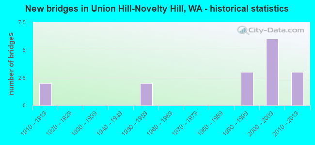
- New bridges - historical statistics
- 21910-1919
- 21950-1959
- 31990-1999
- 62000-2009
- 32010-2019
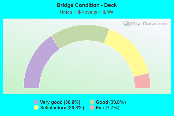
- Bridge Condition - Deck
- 30.8%Very good
- 30.8%Good
- 30.8%Satisfactory
- 7.7%Fair
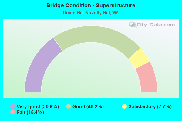
- Bridge Condition - Superstructure
- 30.8%Very good
- 46.2%Good
- 7.7%Satisfactory
- 15.4%Fair
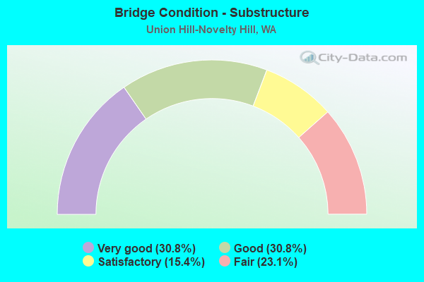
- Bridge Condition - Substructure
- 30.8%Very good
- 30.8%Good
- 15.4%Satisfactory
- 23.1%Fair
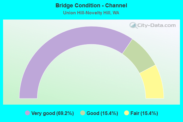
- Bridge Condition - Channel
- 69.2%Very good
- 15.4%Good
- 15.4%Fair
Find on map >> Show street view
Structure Number: 17030A, Location: 1.7 E JCT SR 520 (Lat: 47.655967, Lng: -122.079753), Route carried "on" structure: State highway 202, Year Built: 2007, Status: Open, Structure Length: 2.13m (6.99ft), Average Daily Traffic: 33,884 (year 2019), Truck Traffic: 3%, Average Future Daily Traffic: 47,844 (year 2039), Design Load: HL 93, Features Intersected: EVANS CREEK
Minimum Vertical Clearance: 30+ m (98+ ft), Kilometerpoint: 15.208, Lanes on structure: 5, Base Highway Network: Yes, Owner: State Highway Agency, Approaching Roadway Width: 21.9m (71.9ft), Material/Design: Prestressed concrete, Design/Construction: Slab, Number Of Spans In Main Unit: 1, Length of Maximum Span: 21.0m (68.9ft), Curb-To-Curb Width: 21.9m (71.9ft), Out-to-Out Width: 23.2m (76.1ft)
Condition: Deck: Very good, Superstructure: Very good, Substructure: Very good, Channel: Very good, Operating Rating: 89.8 metric tons, Method Used To Determine Operating Rating: Load Factor (LF), Inventory Rating: 56.2 metric tons, Method Used To Determine Inventory Rating: Load Factor (LF), Structural Evaluation: Equal to present desirable criteria, Deck Geometry: Somewhat better than minimum adequacy, Waterway Adequacy: Equal to present desirable criteria, Approach Roadway Alignment: Equal to present desirable criteria, Length Of Structure Improvement: 2.13m (6.99ft), Designated Inspection Frequency: Every 48 months, Inspection Date: August 2021, Bridge Improvement Cost: $1,036,000, Roadway Improvement Cost: $207,000, Total Project Cost: $2,072,000 ( Estimate for 2014), Deck Structure Type: Other, Wearing Surface/Protective System: Wearing Surface: Bituminous, Membrane: Built-up, Deck Protection: Epoxy Coated Reinforcing
Find on map >> Show street view
Structure Number: 17030B, Location: 1.9 E JCT SR 520 (Lat: 47.655250, Lng: -122.075583), Route carried "on" structure: State highway 202, Year Built: 2007, Status: Open, Structure Length: 4.66m (15.29ft), Average Daily Traffic: 16,657 (year 2019), Truck Traffic: 3%, Average Future Daily Traffic: 23,519 (year 2039), Design Load: HS 20, Features Intersected: DETENTION VAULT
Minimum Vertical Clearance: 30+ m (98+ ft), Kilometerpoint: 15.466, Lanes on structure: 2, Base Highway Network: Yes, Owner: State Highway Agency, Approaching Roadway Width: 10.7m (35.1ft), Material/Design: Concrete, Design/Construction: Culvert, Number Of Spans In Main Unit: 1, Length of Maximum Span: 46.6m (152.9ft)
Condition: Culverts: Very good, Operating Rating: 89.8 metric tons, Method Used To Determine Operating Rating: Load Factor (LF), Inventory Rating: 54.4 metric tons, Method Used To Determine Inventory Rating: Load Factor (LF), Structural Evaluation: Equal to present desirable criteria, Approach Roadway Alignment: Equal to present desirable criteria, Length Of Structure Improvement: 4.66m (15.29ft), Designated Inspection Frequency: Every 24 months, Inspection Date: January 2022, Bridge Improvement Cost: $1,132,000, Roadway Improvement Cost: $226,000, Total Project Cost: $2,264,000 ( Estimate for 2014)
Find on map >> Show street view
Structure Number: 17030C, Location: 2.4 E JCT SR 520 (Lat: 47.656583, Lng: -122.065472), Route carried "on" structure: State highway 202, Year Built: 2006, Status: Open, Structure Length: 2.13m (6.99ft), Average Daily Traffic: 33,720 (year 2019), Truck Traffic: 3%, Average Future Daily Traffic: 47,612 (year 2039), Design Load: HL 93, Features Intersected: EVANS CREEK
Minimum Vertical Clearance: 30+ m (98+ ft), Kilometerpoint: 16.319, Lanes on structure: 4, Base Highway Network: Yes, Owner: State Highway Agency, Approaching Roadway Width: 9.8m (32.2ft), Skew: 30 degrees, Material/Design: Prestressed concrete, Design/Construction: Slab, Number Of Spans In Main Unit: 1, Length of Maximum Span: 21.0m (68.9ft), Curb-To-Curb Width: 22.3m (73.2ft), Out-to-Out Width: 24.4m (80.1ft)
Condition: Deck: Very good, Superstructure: Very good, Substructure: Very good, Channel: Very good, Operating Rating: 89.8 metric tons, Method Used To Determine Operating Rating: Load Factor (LF), Inventory Rating: 54.4 metric tons, Method Used To Determine Inventory Rating: Load Factor (LF), Structural Evaluation: Equal to present desirable criteria, Deck Geometry: Superior to present desirable criteria, Waterway Adequacy: Equal to present desirable criteria, Approach Roadway Alignment: Equal to present desirable criteria, Length Of Structure Improvement: 2.13m (6.99ft), Designated Inspection Frequency: Every 48 months, Inspection Date: August 2021, Bridge Improvement Cost: $476,000, Roadway Improvement Cost: $95,000, Total Project Cost: $952,000 ( Estimate for 2014), Deck Structure Type: Other, Wearing Surface/Protective System: Wearing Surface: Bituminous, Membrane: Preformed Fabric, Deck Protection: Epoxy Coated Reinforcing
Find on map >> Show street view
Structure Number: 17030D, Location: 2.4 E JCT SR 520 (Lat: 47.656683, Lng: -122.065153), Route carried "on" structure: State highway 202, Year Built: 2006, Status: Open, Structure Length: 3.51m (11.52ft), Average Daily Traffic: 16,860 (year 2019), Truck Traffic: 3%, Average Future Daily Traffic: 23,806 (year 2039), Design Load: HL 93, Features Intersected: EVANS CREEK
Minimum Vertical Clearance: 30+ m (98+ ft), Kilometerpoint: 16.335, Lanes on structure: 2, Base Highway Network: Yes, Owner: State Highway Agency, Approaching Roadway Width: 10.4m (34.1ft), Material/Design: Prestressed concrete, Design/Construction: Stringer/Multi-beam, Number Of Spans In Main Unit: 1, Length of Maximum Span: 34.1m (111.9ft), Curb-To-Curb Width: 9.9m (32.5ft), Out-to-Out Width: 10.8m (35.4ft)
Condition: Deck: Very good, Superstructure: Very good, Substructure: Very good, Channel: Very good, Operating Rating: 89.8 metric tons, Method Used To Determine Operating Rating: Load Factor (LF), Inventory Rating: 59.9 metric tons, Method Used To Determine Inventory Rating: Load Factor (LF), Structural Evaluation: Equal to present desirable criteria, Deck Geometry: Meets minimum limits, Waterway Adequacy: Equal to present desirable criteria, Approach Roadway Alignment: Equal to present desirable criteria, Length Of Structure Improvement: 3.51m (11.52ft), Designated Inspection Frequency: Every 24 months, Inspection Date: August 2021, Bridge Improvement Cost: $828,000, Roadway Improvement Cost: $166,000, Total Project Cost: $1,656,000 ( Estimate for 2014), Deck Structure Type: Other, Wearing Surface/Protective System: Wearing Surface: Bituminous, Membrane: Built-up, Deck Protection: Epoxy Coated Reinforcing
Find on map >> Show street view
Structure Number: 17030E, Location: 2.0 E JCT SR 520 (Lat: 47.656364, Lng: -122.070167), Route carried "on" structure: State highway 202, Year Built: 2007, Status: Open, Structure Length: 7.65m (25.10ft), Average Daily Traffic: 16,860 (year 2019), Truck Traffic: 3%, Average Future Daily Traffic: 23,806 (year 2039), Design Load: HS 20, Features Intersected: DETENTION VAULT
Minimum Vertical Clearance: 30+ m (98+ ft), Kilometerpoint: 15.933, Lanes on structure: 2, Base Highway Network: Yes, Owner: State Highway Agency, Approaching Roadway Width: 15.2m (49.9ft), Material/Design: Concrete, Design/Construction: Culvert, Number Of Spans In Main Unit: 1, Length of Maximum Span: 76.5m (251.0ft)
Condition: Culverts: Very good, Operating Rating: 89.8 metric tons, Method Used To Determine Operating Rating: Load Factor (LF), Inventory Rating: 56.2 metric tons, Method Used To Determine Inventory Rating: Load Factor (LF), Structural Evaluation: Equal to present desirable criteria, Approach Roadway Alignment: Equal to present desirable criteria, Length Of Structure Improvement: 7.65m (25.10ft), Designated Inspection Frequency: Every 24 months, Inspection Date: January 2022, Bridge Improvement Cost: $2,610,000, Roadway Improvement Cost: $522,000, Total Project Cost: $5,221,000 ( Estimate for 2014)
Find on map >> Show street view
Structure Number: 80593, Location: 0.5 MI N OF SR-202 (Lat: 47.663161, Lng: -122.078869), Route carried "on" structure: County highway 96803, Year Built: 1913, Status: Open, Structure Length: 0.70m (2.30ft), Average Daily Traffic: 397 (year 2020), Truck Traffic: 7%, Average Future Daily Traffic: 600 (year 2040), Design Load: H 20, Features Intersected: EVANS CREEK, Facility Carried by Structure: 196TH AVE NE
Minimum Vertical Clearance: 30+ m (98+ ft), Kilometerpoint: 0.001, Lanes on structure: 2, Owner: County Highway Agency, Approaching Roadway Width: 8.5m (27.9ft), Skew: 3 degrees, Material/Design: Concrete, Design/Construction: Stringer/Multi-beam, Number Of Spans In Main Unit: 1, Length of Maximum Span: 6.1m (20.0ft), Curb-To-Curb Width: 6.6m (21.7ft), Out-to-Out Width: 7.3m (24.0ft)
Condition: Deck: Fair, Superstructure: Fair, Substructure: Fair, Channel: Very good, Operating Rating: 48.1 metric tons, Method Used To Determine Operating Rating: Load and Resistance Factor (LRFR), Inventory Rating: 29.0 metric tons, Method Used To Determine Inventory Rating: Load and Resistance Factor (LRFR), Structural Evaluation: Somewhat better than minimum adequacy, Deck Geometry: Meets minimum limits, Waterway Adequacy: Equal to present desirable criteria, Approach Roadway Alignment: Equal to present desirable criteria, Length Of Structure Improvement: 1.01m (3.31ft), Designated Inspection Frequency: Every 24 months, Inspection Date: August 2021, Bridge Improvement Cost: $502,000, Roadway Improvement Cost: $100,000, Total Project Cost: $1,003,000 ( Estimate for 2014), Deck Structure Type: Concrete Cast-file-Place, Wearing Surface/Protective System: Wearing Surface: Other
Find on map >> Show street view
Structure Number: 80606, Location: 0.9 MI N OF SR-202 (Lat: 47.669836, Lng: -122.078950), Route carried "on" structure: County highway 96803, Year Built: 1913, Status: Open, Structure Length: 1.01m (3.31ft), Average Daily Traffic: 500 (year 2018), Truck Traffic: 15%, Average Future Daily Traffic: 625 (year 2038), Design Load: H 20, Features Intersected: EVANS CREEK, Facility Carried by Structure: 196TH AVE NE
Minimum Vertical Clearance: 30+ m (98+ ft), Kilometerpoint: 0.001, Lanes on structure: 2, Owner: County Highway Agency, Approaching Roadway Width: 8.5m (27.9ft), Skew: 4 degrees, Material/Design: Concrete, Design/Construction: Stringer/Multi-beam, Number Of Spans In Main Unit: 1, Length of Maximum Span: 8.5m (27.9ft), Curb-To-Curb Width: 6.6m (21.7ft), Out-to-Out Width: 7.3m (24.0ft)
Condition: Deck: Satisfactory, Superstructure: Fair, Substructure: Satisfactory, Channel: Very good, Operating Rating: 32.4 metric tons, Method Used To Determine Operating Rating: Load and Resistance Factor Rating (LRFR) rating reported by rating factor(RF) method using HL-93 loadings, Inventory Rating: 24.9 metric tons, Method Used To Determine Inventory Rating: Load and Resistance Factor Rating (LRFR) rating reported by rating factor(RF) method using HL-93 loadings, Structural Evaluation: Somewhat better than minimum adequacy, Deck Geometry: High priority of corrective action, Waterway Adequacy: Equal to present desirable criteria, Approach Roadway Alignment: Equal to present desirable criteria, Length Of Structure Improvement: 1.31m (4.30ft), Designated Inspection Frequency: Every 24 months, Inspection Date: July 2020, Bridge Improvement Cost: $654,000, Roadway Improvement Cost: $131,000, Total Project Cost: $1,307,000 ( Estimate for 2014), Deck Structure Type: Concrete Precast Panels, Wearing Surface/Protective System: Wearing Surface: Other
Find on map >> Show street view
Structure Number: 84034, Location: 4.75 MI E OF SR-405 (Lat: 47.706639, Lng: -122.089444), Route carried "on" structure: County highway 67030, Year Built: 1950, Status: Open, Structure Length: 1.37m (4.49ft), Average Daily Traffic: 135 (year 2020), Truck Traffic: 10%, Average Future Daily Traffic: 165 (year 2040), Design Load: HS 20, Features Intersected: BEAR CREEK, Facility Carried by Structure: AVONDALE PL NE
Minimum Vertical Clearance: 30+ m (98+ ft), Kilometerpoint: 0.001, Lanes on structure: 2, Owner: County Highway Agency, Approaching Roadway Width: 8.5m (27.9ft), Skew: 2 degrees, Material/Design: Concrete continuous, Design/Construction: Stringer/Multi-beam, Number Of Spans In Main Unit: 3, Length of Maximum Span: 7.6m (24.9ft), Curb or Sidewalk Widths: Left: 0.3m (1.0ft), Right: 0.3m (1.0ft), Curb-To-Curb Width: 7.9m (25.9ft), Out-to-Out Width: 9.1m (29.9ft)
Condition: Deck: Good, Superstructure: Good, Substructure: Fair, Channel: Fair, Operating Rating: 27.5 metric tons, Method Used To Determine Operating Rating: Load and Resistance Factor Rating (LRFR) rating reported by rating factor(RF) method using HL-93 loadings, Inventory Rating: 19.8 metric tons, Method Used To Determine Inventory Rating: Load and Resistance Factor Rating (LRFR) rating reported by rating factor(RF) method using HL-93 loadings, Structural Evaluation: Somewhat better than minimum adequacy, Deck Geometry: Somewhat better than minimum adequacy, Waterway Adequacy: Equal to present desirable criteria, Approach Roadway Alignment: Equal to present desirable criteria, Length Of Structure Improvement: 1.68m (5.51ft), Designated Inspection Frequency: Every 24 months, Inspection Date: August 2020, Bridge Improvement Cost: $836,000, Roadway Improvement Cost: $167,000, Total Project Cost: $1,672,000 ( Estimate for 2014), Deck Structure Type: Concrete Cast-file-Place, Wearing Surface/Protective System: Wearing Surface: Bituminous
Find on map >> Show street view
Structure Number: 84158, Location: 0.1 MI E OF AVONDALE RD (Lat: 47.694250, Lng: -122.091833), Route carried "on" structure: County highway 66942, Year Built: 1953, Year Reconstructed: 2009, Status: Open, Structure Length: 0.79m (2.59ft), Average Daily Traffic: 180 (year 2020), Truck Traffic: 5%, Average Future Daily Traffic: 350 (year 2040), Design Load: H 20, Features Intersected: BEAR CREEK, Facility Carried by Structure: NE 106TH ST
Minimum Vertical Clearance: 30+ m (98+ ft), Kilometerpoint: 0.001, Lanes on structure: 1, Owner: County Highway Agency, Approaching Roadway Width: 6.1m (20.0ft), Material/Design: Wood or Timber, Design/Construction: Stringer/Multi-beam, Number Of Spans In Main Unit: 1, Length of Maximum Span: 7.6m (24.9ft), Curb-To-Curb Width: 5.2m (17.1ft), Out-to-Out Width: 5.5m (18.0ft)
Condition: Deck: Good, Superstructure: Good, Substructure: Fair, Channel: Good, Operating Rating: 82.5 metric tons, Method Used To Determine Operating Rating: Allowable Stress (AS), Inventory Rating: 60.8 metric tons, Method Used To Determine Inventory Rating: Allowable Stress (AS), Structural Evaluation: Somewhat better than minimum adequacy, Deck Geometry: High priority of replacement, Waterway Adequacy: Meets minimum limits, Approach Roadway Alignment: Equal to present desirable criteria, Length Of Structure Improvement: 1.10m (3.61ft), Designated Inspection Frequency: Every 24 months, Inspection Date: July 2020, Bridge Improvement Cost: $374,000, Roadway Improvement Cost: $75,000, Total Project Cost: $749,000 ( Estimate for 2014), Deck Structure Type: Wood or Timber, Wearing Surface/Protective System: Wearing Surface: Wood or Timber
Find on map >> Show street view
Structure Number: 86186, Location: 4.3 MI E OF SR-405 (Lat: 47.707556, Lng: -122.090139), Route carried "on" structure: County highway 96809, Year Built: 1995, Status: Open, Structure Length: 2.04m (6.69ft), Average Daily Traffic: 24,768 (year 2019), Truck Traffic: 2%, Average Future Daily Traffic: 26,000 (year 2040), Design Load: HS 20, Features Intersected: BEAR CREEK, Facility Carried by Structure: AVONDALE ROAD
Minimum Vertical Clearance: 30+ m (98+ ft), Kilometerpoint: 0.001, Lanes on structure: 5, Base Highway Network: Yes, Owner: County Highway Agency, Approaching Roadway Width: 20.1m (65.9ft), Skew: 1 degrees, Material/Design: Prestressed concrete, Design/Construction: Stringer/Multi-beam, Number Of Spans In Main Unit: 1, Length of Maximum Span: 19.8m (65.0ft), Curb or Sidewalk Widths: Left: 1.7m (5.6ft), Right: 1.7m (5.6ft), Curb-To-Curb Width: 20.1m (65.9ft), Out-to-Out Width: 25.6m (84.0ft)
Condition: Deck: Satisfactory, Superstructure: Good, Substructure: Good, Channel: Very good, Operating Rating: 68.9 metric tons, Method Used To Determine Operating Rating: Load Factor (LF), Inventory Rating: 41.7 metric tons, Method Used To Determine Inventory Rating: Load Factor (LF), Structural Evaluation: Better than present minimum criteria, Deck Geometry: Somewhat better than minimum adequacy, Waterway Adequacy: Equal to present desirable criteria, Approach Roadway Alignment: Equal to present desirable criteria, Length Of Structure Improvement: 2.35m (7.71ft), Designated Inspection Frequency: Every 24 months, Inspection Date: August 2020, Bridge Improvement Cost: $2,279,000, Roadway Improvement Cost: $456,000, Total Project Cost: $4,558,000 ( Estimate for 2014), Deck Structure Type: Concrete Cast-file-Place, Wearing Surface/Protective System: Wearing Surface: Monolithic Concrete, Deck Protection: Epoxy Coated Reinforcing
Find on map >> Show street view
Structure Number: 86238, Location: 4.7 MI E OF SR-405 (Lat: 47.710722, Lng: -122.089000), Route carried "on" structure: County highway 96809, Year Built: 1995, Status: Open, Structure Length: 3.75m (12.30ft), Average Daily Traffic: 23,710 (year 2017), Truck Traffic: 3%, Average Future Daily Traffic: 27,000 (year 2037), Design Load: HS 20, Features Intersected: BEAR CREEK, Facility Carried by Structure: AVONDALE ROAD
Minimum Vertical Clearance: 30+ m (98+ ft), Kilometerpoint: 0.001, Lanes on structure: 5, Base Highway Network: Yes, Owner: County Highway Agency, Approaching Roadway Width: 20.1m (65.9ft), Skew: 2 degrees, Material/Design: Prestressed concrete, Design/Construction: Stringer/Multi-beam, Number Of Spans In Main Unit: 1, Length of Maximum Span: 36.9m (121.1ft), Curb or Sidewalk Widths: Left: 1.7m (5.6ft), Right: 1.7m (5.6ft), Curb-To-Curb Width: 20.1m (65.9ft), Out-to-Out Width: 24.1m (79.1ft)
Condition: Deck: Satisfactory, Superstructure: Good, Substructure: Good, Channel: Fair, Operating Rating: 89.8 metric tons, Method Used To Determine Operating Rating: Load Factor (LF), Inventory Rating: 58.0 metric tons, Method Used To Determine Inventory Rating: Load Factor (LF), Structural Evaluation: Better than present minimum criteria, Deck Geometry: Somewhat better than minimum adequacy, Waterway Adequacy: Equal to present desirable criteria, Approach Roadway Alignment: Equal to present desirable criteria, Length Of Structure Improvement: 4.05m (13.29ft), Designated Inspection Frequency: Every 24 months, Inspection Date: August 2020, Bridge Improvement Cost: $3,937,000, Roadway Improvement Cost: $787,000, Total Project Cost: $7,874,000 ( Estimate for 2014), Deck Structure Type: Concrete Cast-file-Place, Wearing Surface/Protective System: Wearing Surface: Monolithic Concrete, Deck Protection: Epoxy Coated Reinforcing
Find on map >> Show street view
Structure Number: 86333, Location: 1.8 MI E OF SR-202 (Lat: 47.716667, Lng: -122.088278), Route carried "on" structure: County highway 96809, Year Built: 1994, Status: Open, Structure Length: 1.86m (6.10ft), Average Daily Traffic: 25,321 (year 2019), Truck Traffic: 6%, Average Future Daily Traffic: 45,735 (year 2039), Design Load: HS 20, Features Intersected: COTTAGE LAKE CREEK, Facility Carried by Structure: AVONDALE ROAD NE
Minimum Vertical Clearance: 30+ m (98+ ft), Kilometerpoint: 0.001, Lanes on structure: 5, Base Highway Network: Yes, Owner: County Highway Agency, Approaching Roadway Width: 20.1m (65.9ft), Skew: 4 degrees, Material/Design: Concrete, Design/Construction: Slab, Number Of Spans In Main Unit: 1, Length of Maximum Span: 17.4m (57.1ft), Curb or Sidewalk Widths: Left: 2.7m (8.9ft), Right: 2.7m (8.9ft), Curb-To-Curb Width: 20.1m (65.9ft), Out-to-Out Width: 25.6m (84.0ft)
Condition: Deck: Satisfactory, Superstructure: Satisfactory, Substructure: Satisfactory, Channel: Very good, Operating Rating: 96.9 metric tons, Method Used To Determine Operating Rating: Load and Resistance Factor Rating (LRFR) rating reported by rating factor(RF) method using HL-93 loadings, Inventory Rating: 82.0 metric tons, Method Used To Determine Inventory Rating: Load and Resistance Factor Rating (LRFR) rating reported by rating factor(RF) method using HL-93 loadings, Structural Evaluation: Equal to present minimum criteria, Deck Geometry: Somewhat better than minimum adequacy, Waterway Adequacy: Equal to present desirable criteria, Approach Roadway Alignment: Equal to present desirable criteria, Length Of Structure Improvement: 2.16m (7.09ft), Designated Inspection Frequency: Every 24 months, Inspection Date: August 2021, Bridge Improvement Cost: $2,102,000, Roadway Improvement Cost: $420,000, Total Project Cost: $4,203,000 ( Estimate for 2014), Deck Structure Type: Concrete Cast-file-Place, Wearing Surface/Protective System: Wearing Surface: Bituminous, Deck Protection: Epoxy Coated Reinforcing
Find on map >> Show street view
Structure Number: 86513, Location: 0.5 MI W OF SR 203 (Lat: 47.708981, Lng: -121.996753), Route carried "on" structure: County highway 88600, Year Built: 2000, Status: Open, Structure Length: 19.02m (62.40ft), Average Daily Traffic: 10,400 (year 2019), Truck Traffic: 5%, Average Future Daily Traffic: 13,500 (year 2039), Design Load: HS 25 or greater, Features Intersected: SNOQUALMIE RIVER, Facility Carried by Structure: NE 124TH ST
Minimum Vertical Clearance: 5.11m (16.77ft), Kilometerpoint: 0.001, Lanes on structure: 2, Owner: County Highway Agency, Approaching Roadway Width: 11.9m (39.0ft), Material/Design: Steel, Design/Construction: Arch - Thru, Number Of Spans In Main Unit: 1, Number Of Approach Spans: 4, Length of Maximum Span: 89.9m (294.9ft), Curb-To-Curb Width: 12.0m (39.4ft), Out-to-Out Width: 14.4m (47.2ft)
Condition: Deck: Good, Superstructure: Good, Substructure: Good, Channel: Good, Operating Rating: 42.1 metric tons, Method Used To Determine Operating Rating: Load and Resistance Factor Rating (LRFR) rating reported by rating factor(RF) method using HL-93 loadings, Inventory Rating: 32.4 metric tons, Method Used To Determine Inventory Rating: Load and Resistance Factor Rating (LRFR) rating reported by rating factor(RF) method using HL-93 loadings, Structural Evaluation: Better than present minimum criteria, Deck Geometry: Somewhat better than minimum adequacy, Waterway Adequacy: Meets minimum limits, Approach Roadway Alignment: Equal to present desirable criteria, Length Of Structure Improvement: 19.32m (63.39ft), Designated Inspection Frequency: Every 24 months, Critical Feature Inspection Frequency: Every 24 months, Inspection Date: April 2021, Critical Feature Inspection Date: April 2021, Bridge Improvement Cost: $9,637,000, Roadway Improvement Cost: $1,927,000, Total Project Cost: $19,274,000 ( Estimate for 2014), Deck Structure Type: Concrete Cast-file-Place, Wearing Surface/Protective System: Wearing Surface: Monolithic Concrete, Membrane: Preformed Fabric
Find on map >> Show street view
Structure Number: 88565, Location: 2.5 MI E OF SR-202 (Lat: 47.675139, Lng: -122.081306), Route carried "on" structure: County highway 96803, Year Built: 2013, Status: Open, Structure Length: 2.10m (6.89ft), Average Daily Traffic: 18,724 (year 2019), Truck Traffic: 11%, Average Future Daily Traffic: 27,000 (year 2037), Design Load: HL 93, Features Intersected: EVANS CREEK, Facility Carried by Structure: NE UNION HILL RD.
Minimum Vertical Clearance: 30+ m (98+ ft), Kilometerpoint: 0.001, Lanes on structure: 4, Owner: County Highway Agency, Approaching Roadway Width: 19.8m (65.0ft), Material/Design: Prestressed concrete, Design/Construction: Slab, Number Of Spans In Main Unit: 1, Length of Maximum Span: 19.8m (65.0ft), Curb-To-Curb Width: 19.8m (65.0ft), Out-to-Out Width: 20.8m (68.2ft)
Condition: Deck: Good, Superstructure: Good, Substructure: Good, Channel: Very good, Operating Rating: 83.6 metric tons, Method Used To Determine Operating Rating: Load and Resistance Factor Rating (LRFR) rating reported by rating factor(RF) method using HL-93 loadings, Inventory Rating: 64.5 metric tons, Method Used To Determine Inventory Rating: Load and Resistance Factor Rating (LRFR) rating reported by rating factor(RF) method using HL-93 loadings, Structural Evaluation: Better than present minimum criteria, Deck Geometry: Better than present minimum criteria, Waterway Adequacy: Equal to present desirable criteria, Approach Roadway Alignment: Equal to present desirable criteria, Length Of Structure Improvement: 2.10m (6.89ft), Designated Inspection Frequency: Every 24 months, Inspection Date: July 2020, Bridge Improvement Cost: $924,000, Roadway Improvement Cost: $185,000, Total Project Cost: $1,849,000 ( Estimate for 2014), Deck Structure Type: Concrete Cast-file-Place, Wearing Surface/Protective System: Wearing Surface: Monolithic Concrete, Deck Protection: Epoxy Coated Reinforcing
Find on map >> Show street view
Structure Number: 88868, Location: 2.1 MI E OF SR-203 (Lat: 47.665028, Lng: -121.971111), Route carried "on" structure: County highway 96812, Year Built: 2016, Status: Open, Structure Length: 0.94m (3.08ft), Average Daily Traffic: 660 (year 2021), Truck Traffic: 5%, Average Future Daily Traffic: 1,350 (year 2041), Design Load: HL 93, Features Intersected: DRAINAGE DITCH, Facility Carried by Structure: W SNO VALLEY RD
Minimum Vertical Clearance: 30+ m (98+ ft), Kilometerpoint: 0.001, Lanes on structure: 2, Owner: County Highway Agency, Approaching Roadway Width: 9.1m (29.9ft), Material/Design: Concrete, Design/Construction: Slab, Number Of Spans In Main Unit: 1, Length of Maximum Span: 7.9m (25.9ft), Curb-To-Curb Width: 8.5m (27.9ft), Out-to-Out Width: 9.4m (30.8ft)
Condition: Deck: Very good, Superstructure: Very good, Substructure: Very good, Channel: Very good, Operating Rating: 96.9 metric tons, Method Used To Determine Operating Rating: Load and Resistance Factor Rating (LRFR) rating reported by rating factor(RF) method using HL-93 loadings, Inventory Rating: 61.9 metric tons, Method Used To Determine Inventory Rating: Load and Resistance Factor Rating (LRFR) rating reported by rating factor(RF) method using HL-93 loadings, Structural Evaluation: Equal to present desirable criteria, Deck Geometry: Somewhat better than minimum adequacy, Waterway Adequacy: Equal to present desirable criteria, Approach Roadway Alignment: Equal to present desirable criteria, Length Of Structure Improvement: 0.94m (3.08ft), Designated Inspection Frequency: Every 24 months, Inspection Date: June 2021, Bridge Improvement Cost: $198,000, Roadway Improvement Cost: $40,000, Total Project Cost: $397,000 ( Estimate for 2014), Deck Structure Type: Concrete Precast Panels, Wearing Surface/Protective System: Wearing Surface: Integral Concrete, Deck Protection: Epoxy Coated Reinforcing
Find on map >> Show street view
Structure Number: 88652, Location: 2.5 MI N OF SR 202 (Lat: 47.698278, Lng: -122.032556), Route carried "under" structure: County highway 96800, Year Built: 2013, Structure Length: 0. m, Average Daily Traffic: 21,200 (year 2016), Truck Traffic: 9%, Features Intersected: NOVELTY HILL RD, Facility Carried by Structure: WILDLIFE CORRIDOR
Minimum Vertical Clearance: 5.03m (16.50ft), Kilometerpoint: 0.001, Lanes under structure: 2, Material/Design: Prestressed concrete, Design/Construction: Tee Beam, Length of Maximum Span: 36.6m (120.1ft)