Bridge Statistics for Uniontown, Alabama (AL)
Condition, Traffic, Stress, Structural Evaluation, Project Costs
- National Bridge Inventory (NBI) Statistics
- 19Number of bridges
- 138ft / 41.5mTotal length
- $13,059,000Total costs
- 11,470Total average daily traffic
- 2,084Total average daily truck traffic
- 15,448Total future (year 2032) average daily traffic
- National Bridge Inventory (NBI) Registered Bridges for Uniontown
- No street view available for this location
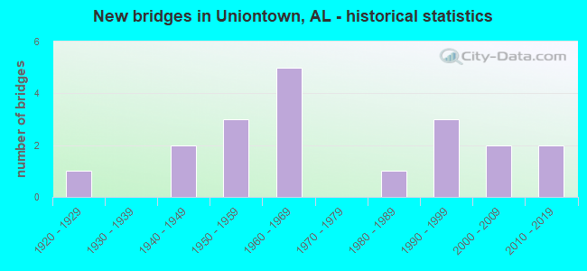
- New bridges - historical statistics
- 11920-1929
- 21940-1949
- 31950-1959
- 51960-1969
- 11980-1989
- 31990-1999
- 22000-2009
- 22010-2019

- Reconstructed bridges - Historical Statistics
- 11930-1939
- 01940-1949
- 01950-1959
- 01960-1969
- 01970-1979
- 31980-1989


- Bridge Condition - Deck
- 30.0%Good
- 40.0%Satisfactory
- 30.0%Fair

- Bridge Condition - Superstructure
- 10.0%Very good
- 50.0%Good
- 20.0%Satisfactory
- 20.0%Fair

- Bridge Condition - Substructure
- 10.0%Very good
- 40.0%Good
- 20.0%Satisfactory
- 10.0%Poor
- 20.0%Serious

- Bridge Condition - Channel
- 10.5%Very good
- 21.1%Good
- 36.8%Satisfactory
- 26.3%Fair
- 5.3%Poor

- Bridge Condition - Culverts
- 11.1%Very good
- 11.1%Good
- 55.6%Satisfactory
- 22.2%Fair
Find on map >> Show street view
Structure Number: 2923, Location: DALLAS CO LINE (Lat: 32.445750, Lng: -87.423133), Route carried "on" structure: US 80, Year Built: 1946, Status: Open, Structure Length: 7.24m (23.75ft), Average Daily Traffic: 2,165 (year 2016), Truck Traffic: 30%, Average Future Daily Traffic: 2,831 (year 2036), Design Load: H 20, Features Intersected: COFFEE CREEK
Minimum Vertical Clearance: 30+ m (98+ ft), Kilometerpoint: 96.417, Lanes on structure: 2, Base Highway Network: Yes, Owner: State Highway Agency, Approaching Roadway Width: 11.0m (36.1ft), Skew: 10 degrees, Material/Design: Concrete, Design/Construction: Tee Beam, Number Of Spans In Main Unit: 7, Length of Maximum Span: 10.4m (34.1ft), Curb or Sidewalk Widths: Left: 0.5m (1.6ft), Right: 0.5m (1.6ft), Curb-To-Curb Width: 7.9m (25.9ft), Out-to-Out Width: 9.1m (29.9ft)
Condition: Deck: Fair, Superstructure: Satisfactory, Substructure: Good, Channel: Satisfactory, Operating Rating: 38.9 metric tons, Method Used To Determine Operating Rating: Load Factor (LF), Inventory Rating: 23.4 metric tons, Method Used To Determine Inventory Rating: Load Factor (LF), Structural Evaluation: Equal to present minimum criteria, Deck Geometry: High priority of replacement, Waterway Adequacy: Equal to present minimum criteria, Approach Roadway Alignment: Equal to present desirable criteria, Length Of Structure Improvement: 8.27m (27.13ft), Designated Inspection Frequency: Every 24 months, Inspection Date: June 2020, Bridge Improvement Cost: $1,644,000, Roadway Improvement Cost: $164,000, Total Project Cost: $1,808,000 ( Estimate for 2022), Deck Structure Type: Concrete Cast-file-Place
Find on map >> Show street view
Structure Number: 5029, Location: 3.6 MI.E. OF LANEVILLE (Lat: 32.496803, Lng: -87.558417), Route carried "on" structure: County highway , Year Built: 1955, Year Reconstructed: 1991, Status: Posted for load, Structure Length: 1.71m (5.61ft), Average Daily Traffic: 50 (year 1991), Average Future Daily Traffic: 100 (year 2034), Design Load: H 10, Features Intersected: TRIB. TO GREER CREEK, Facility Carried by Structure: GREER CREEK ROAD
Minimum Vertical Clearance: 30+ m (98+ ft), Kilometerpoint: 0.010, Lanes on structure: 1, Owner: County Highway Agency, Approaching Roadway Width: 5.5m (18.0ft), Material/Design: Steel, Design/Construction: Stringer/Multi-beam, Number Of Spans In Main Unit: 2, Length of Maximum Span: 8.5m (27.9ft), Curb-To-Curb Width: 5.2m (17.1ft), Out-to-Out Width: 5.2m (17.1ft)
Condition: Deck: Satisfactory, Superstructure: Satisfactory, Substructure: Serious, Channel: Fair, Operating Rating: 2.7 metric tons, Method Used To Determine Operating Rating: Load Factor (LF), Inventory Rating: 1.8 metric tons, Method Used To Determine Inventory Rating: Load Factor (LF), Structural Evaluation: High priority of replacement, Deck Geometry: High priority of corrective action, Waterway Adequacy: Equal to present minimum criteria, Approach Roadway Alignment: Equal to present desirable criteria, Bridge Posting: Required (Relationship of Operating Rating to Maximum Legal Load: > 39.9% below), Length Of Structure Improvement: 2.41m (7.91ft), Designated Inspection Frequency: Every 24 months, Other Special Inspection Frequency: Every 2 months, Inspection Date: December 2020, Other Special Inspection Date: January 2022, Bridge Improvement Cost: $281,000, Roadway Improvement Cost: $28,000, Total Project Cost: $309,000 ( Estimate for 2022), Deck Structure Type: Wood or Timber, Wearing Surface/Protective System: Wearing Surface: Wood or Timber
Find on map >> Show street view
Structure Number: 503, Location: 4.0 MI.E. OF LANEVILLE (Lat: 32.493908, Lng: -87.558244), Route carried "on" structure: County highway , Year Built: 1955, Status: Posted for load, Structure Length: 1.65m (5.41ft), Average Daily Traffic: 50 (year 1989), Average Future Daily Traffic: 100 (year 2034), Design Load: H 10, Features Intersected: TRIB. TO GREER CREEK, Facility Carried by Structure: GREER CREEK ROAD
Minimum Vertical Clearance: 30+ m (98+ ft), Kilometerpoint: 0.010, Lanes on structure: 1, Owner: County Highway Agency, Approaching Roadway Width: 4.9m (16.1ft), Material/Design: Steel, Design/Construction: Stringer/Multi-beam, Number Of Spans In Main Unit: 2, Length of Maximum Span: 8.2m (26.9ft), Curb-To-Curb Width: 4.9m (16.1ft), Out-to-Out Width: 4.9m (16.1ft)
Condition: Deck: Fair, Superstructure: Fair, Substructure: Serious, Channel: Poor, Operating Rating: 2.7 metric tons, Method Used To Determine Operating Rating: Load Factor (LF), Inventory Rating: 1.8 metric tons, Method Used To Determine Inventory Rating: Load Factor (LF), Structural Evaluation: High priority of replacement, Deck Geometry: High priority of corrective action, Waterway Adequacy: Better than present minimum criteria, Approach Roadway Alignment: Somewhat better than minimum adequacy, Bridge Posting: Required (Relationship of Operating Rating to Maximum Legal Load: > 39.9% below), Length Of Structure Improvement: 2.34m (7.68ft), Designated Inspection Frequency: Every 24 months, Other Special Inspection Frequency: Every 1 months, Inspection Date: September 2021, Other Special Inspection Date: Febuary 2022, Bridge Improvement Cost: $257,000, Roadway Improvement Cost: $26,000, Total Project Cost: $283,000 ( Estimate for 2022), Deck Structure Type: Wood or Timber, Wearing Surface/Protective System: Wearing Surface: Wood or Timber
Find on map >> Show street view
Structure Number: 6569, Location: 7 MILE EAST U TOWN (Lat: 32.490106, Lng: -87.415078), Route carried "on" structure: County highway 12, Year Built: 1959, Status: Posted for load, Structure Length: 5.18m (16.99ft), Average Daily Traffic: 370 (year 1993), Truck Traffic: 5%, Average Future Daily Traffic: 425 (year 2033), Design Load: H 15, Features Intersected: WATER SHED CREEK, Facility Carried by Structure: DUNCAN RD FAS 03
Minimum Vertical Clearance: 30+ m (98+ ft), Kilometerpoint: 0.010, Lanes on structure: 2, Owner: County Highway Agency, Approaching Roadway Width: 8.5m (27.9ft), Material/Design: Concrete, Design/Construction: Tee Beam, Number Of Spans In Main Unit: 5, Length of Maximum Span: 10.4m (34.1ft), Curb-To-Curb Width: 6.7m (22.0ft), Out-to-Out Width: 7.0m (23.0ft)
Condition: Deck: Good, Superstructure: Good, Substructure: Satisfactory, Channel: Satisfactory, Operating Rating: 41.8 metric tons, Method Used To Determine Operating Rating: Allowable Stress (AS), Inventory Rating: 25.1 metric tons, Method Used To Determine Inventory Rating: Allowable Stress (AS), Structural Evaluation: Equal to present minimum criteria, Deck Geometry: Meets minimum limits, Waterway Adequacy: Better than present minimum criteria, Approach Roadway Alignment: Better than present minimum criteria, Bridge Posting: Required (Relationship of Operating Rating to Maximum Legal Load: 0.1 - 9.9% below), Length Of Structure Improvement: 6.20m (20.34ft), Designated Inspection Frequency: Every 24 months, Other Special Inspection Frequency: Every 12 months, Inspection Date: August 2021, Other Special Inspection Date: August 2021, Bridge Improvement Cost: $978,000, Roadway Improvement Cost: $98,000, Total Project Cost: $1,076,000 ( Estimate for 2022), Deck Structure Type: Concrete Cast-file-Place
Find on map >> Show street view
Structure Number: 6854, Location: 3.8 MI. E. OF LANEVILLE (Lat: 32.496786, Lng: -87.558447), Route carried "on" structure: County highway , Year Built: 1960, Status: Posted for load, Structure Length: 1.83m (6.00ft), Average Daily Traffic: 50 (year 1989), Average Future Daily Traffic: 100 (year 2035), Design Load: H 10, Features Intersected: GREER CREEK, Facility Carried by Structure: GREER CREEK RD.
Minimum Vertical Clearance: 30+ m (98+ ft), Kilometerpoint: 0.010, Lanes on structure: 1, Owner: County Highway Agency, Approaching Roadway Width: 4.9m (16.1ft), Material/Design: Wood or Timber, Design/Construction: Stringer/Multi-beam, Number Of Spans In Main Unit: 4, Length of Maximum Span: 4.9m (16.1ft), Curb-To-Curb Width: 4.9m (16.1ft), Out-to-Out Width: 4.9m (16.1ft)
Condition: Deck: Fair, Superstructure: Fair, Substructure: Poor, Channel: Satisfactory, Operating Rating: 2.7 metric tons, Method Used To Determine Operating Rating: Allowable Stress (AS), Inventory Rating: 1.8 metric tons, Method Used To Determine Inventory Rating: Allowable Stress (AS), Structural Evaluation: High priority of replacement, Deck Geometry: High priority of corrective action, Waterway Adequacy: Equal to present minimum criteria, Approach Roadway Alignment: Equal to present minimum criteria, Bridge Posting: Required (Relationship of Operating Rating to Maximum Legal Load: > 39.9% below), Length Of Structure Improvement: 2.54m (8.33ft), Designated Inspection Frequency: Every 24 months, Other Special Inspection Frequency: Every 3 months, Inspection Date: January 2022, Other Special Inspection Date: January 2022, Bridge Improvement Cost: $279,000, Roadway Improvement Cost: $28,000, Total Project Cost: $307,000 ( Estimate for 2022), Deck Structure Type: Wood or Timber, Wearing Surface/Protective System: Wearing Surface: Wood or Timber
Find on map >> Show street view
Structure Number: 8704, Location: CR 12 U'TOWN (Lat: 32.461667, Lng: -87.470000), Route carried "on" structure: County highway 12, Year Built: 1965, Status: Open, Structure Length: 0.91m (2.99ft), Average Daily Traffic: 315 (year 1993), Truck Traffic: 5%, Average Future Daily Traffic: 400 (year 2032), Design Load: H 10, Features Intersected: COFFEE CREEK
Minimum Vertical Clearance: 30+ m (98+ ft), Kilometerpoint: 0.010, Lanes on structure: 2, Owner: County Highway Agency, Approaching Roadway Width: 6.1m (20.0ft), Material/Design: Concrete, Design/Construction: Culvert, Number Of Spans In Main Unit: 3, Length of Maximum Span: 3.0m (9.8ft), Out-to-Out Width: 9.2m (30.2ft)
Condition: Channel: Fair, Culverts: Satisfactory, Operating Rating: 78.0 metric tons, Method Used To Determine Operating Rating: Load Factor (LF), Inventory Rating: 46.8 metric tons, Method Used To Determine Inventory Rating: Load Factor (LF), Structural Evaluation: Equal to present minimum criteria, Waterway Adequacy: Better than present minimum criteria, Approach Roadway Alignment: Equal to present desirable criteria, Length Of Structure Improvement: 1.58m (5.18ft), Designated Inspection Frequency: Every 24 months, Inspection Date: August 2021, Bridge Improvement Cost: $274,000, Roadway Improvement Cost: $27,000, Total Project Cost: $301,000 ( Estimate for 2022), Wearing Surface/Protective System: Wearing Surface: Bituminous
Find on map >> Show street view
Structure Number: 9301, Location: STEVENS MEM. RD 3 (Lat: 32.508333, Lng: -87.466667), Route carried "on" structure: County highway 46, Year Built: 1967, Year Reconstructed: 1992, Status: Open, Structure Length: 0.79m (2.59ft), Average Daily Traffic: 120 (year 1991), Truck Traffic: 2%, Average Future Daily Traffic: 150 (year 2032), Design Load: HS 20, Features Intersected: MUD CREEK
Minimum Vertical Clearance: 7.56m (24.80ft), Kilometerpoint: 0.010, Lanes on structure: 2, Owner: County Highway Agency, Approaching Roadway Width: 6.5m (21.3ft), Material/Design: Concrete, Design/Construction: Culvert, Number Of Spans In Main Unit: 2, Length of Maximum Span: 3.7m (12.1ft), Out-to-Out Width: 14.9m (48.9ft)
Condition: Channel: Satisfactory, Culverts: Satisfactory, Operating Rating: 67.0 metric tons, Method Used To Determine Operating Rating: Load Factor (LF), Inventory Rating: 40.2 metric tons, Method Used To Determine Inventory Rating: Load Factor (LF), Structural Evaluation: Equal to present minimum criteria, Waterway Adequacy: Equal to present minimum criteria, Approach Roadway Alignment: Better than present minimum criteria, Length Of Structure Improvement: 1.44m (4.72ft), Designated Inspection Frequency: Every 24 months, Inspection Date: September 2021, Bridge Improvement Cost: $392,000, Roadway Improvement Cost: $39,000, Total Project Cost: $431,000 ( Estimate for 2022)
Find on map >> Show street view
Structure Number: 9302, Location: STEVENS MEM. (Lat: 32.510000, Lng: -87.458333), Route carried "on" structure: County highway 46, Year Built: 1967, Year Reconstructed: 1992, Status: Open, Structure Length: 0.98m (3.22ft), Average Daily Traffic: 120 (year 1991), Truck Traffic: 2%, Average Future Daily Traffic: 150 (year 2032), Design Load: HS 20, Features Intersected: TRIB. MUD CREEK
Minimum Vertical Clearance: 7.56m (24.80ft), Kilometerpoint: 0.010, Lanes on structure: 2, Owner: County Highway Agency, Approaching Roadway Width: 6.5m (21.3ft), Material/Design: Concrete, Design/Construction: Culvert, Number Of Spans In Main Unit: 3, Length of Maximum Span: 3.0m (9.8ft), Curb-To-Curb Width: 14.3m (46.9ft), Out-to-Out Width: 14.6m (47.9ft)
Condition: Channel: Satisfactory, Culverts: Good, Operating Rating: 65.0 metric tons, Method Used To Determine Operating Rating: Load Factor (LF), Inventory Rating: 39.0 metric tons, Method Used To Determine Inventory Rating: Load Factor (LF), Structural Evaluation: Better than present minimum criteria, Deck Geometry: Superior to present desirable criteria, Waterway Adequacy: Better than present minimum criteria, Approach Roadway Alignment: Better than present minimum criteria, Length Of Structure Improvement: 1.65m (5.41ft), Designated Inspection Frequency: Every 24 months, Inspection Date: September 2021, Bridge Improvement Cost: $449,000, Roadway Improvement Cost: $45,000, Total Project Cost: $494,000 ( Estimate for 2022)
Find on map >> Show street view
Structure Number: 9732, Location: 4 5M SOUTH OF UNION TOWN (Lat: 32.386972, Lng: -87.513750), Route carried "on" structure: County highway 65, Year Built: 1968, Status: Open, Structure Length: 0.91m (2.99ft), Average Daily Traffic: 325 (year 1993), Truck Traffic: 5%, Average Future Daily Traffic: 600 (year 2032), Design Load: H 10, Features Intersected: FREETOWN CREEK
Minimum Vertical Clearance: 30+ m (98+ ft), Kilometerpoint: 0.010, Lanes on structure: 2, Owner: County Highway Agency, Approaching Roadway Width: 6.1m (20.0ft), Skew: 4 degrees, Material/Design: Concrete, Design/Construction: Culvert, Number Of Spans In Main Unit: 3, Length of Maximum Span: 3.0m (9.8ft), Out-to-Out Width: 16.9m (55.4ft)
Condition: Channel: Fair, Culverts: Fair, Operating Rating: 88.9 metric tons, Method Used To Determine Operating Rating: Load Factor (LF), Inventory Rating: 55.2 metric tons, Method Used To Determine Inventory Rating: Load Factor (LF), Structural Evaluation: Somewhat better than minimum adequacy, Waterway Adequacy: Better than present minimum criteria, Approach Roadway Alignment: Somewhat better than minimum adequacy, Length Of Structure Improvement: 1.58m (5.18ft), Designated Inspection Frequency: Every 24 months, Inspection Date: November 2021, Bridge Improvement Cost: $474,000, Roadway Improvement Cost: $47,000, Total Project Cost: $521,000 ( Estimate for 2022)
Find on map >> Show street view
Structure Number: 14182, Location: TAYLOE RD. (Lat: 32.445583, Lng: -87.440222), Route carried "on" structure: County highway 13, Year Built: 1987, Status: Open, Structure Length: 0.73m (2.40ft), Average Daily Traffic: 100 (year 1991), Average Future Daily Traffic: 150 (year 2033), Design Load: HS 20, Features Intersected: TAYLOE CRK BRANCH
Minimum Vertical Clearance: 30+ m (98+ ft), Kilometerpoint: 0.010, Lanes on structure: 2, Owner: County Highway Agency, Approaching Roadway Width: 8.5m (27.9ft), Skew: 3 degrees, Material/Design: Concrete, Design/Construction: Culvert, Number Of Spans In Main Unit: 2, Length of Maximum Span: 3.0m (9.8ft), Out-to-Out Width: 23.7m (77.8ft)
Condition: Channel: Good, Culverts: Satisfactory, Operating Rating: 34.7 metric tons, Method Used To Determine Operating Rating: Load Factor (LF), Inventory Rating: 20.9 metric tons, Method Used To Determine Inventory Rating: Load Factor (LF), Structural Evaluation: Equal to present minimum criteria, Waterway Adequacy: Better than present minimum criteria, Approach Roadway Alignment: Better than present minimum criteria, Length Of Structure Improvement: 1.38m (4.53ft), Designated Inspection Frequency: Every 24 months, Inspection Date: July 2021, Bridge Improvement Cost: $159,000, Roadway Improvement Cost: $16,000, Total Project Cost: $175,000 ( Estimate for 2022), Wearing Surface/Protective System: Wearing Surface: Gravel
Find on map >> Show street view
Structure Number: 15134, Location: 3.2 MI.W.OF AL.5 (Lat: 32.444750, Lng: -87.461350), Route carried "on" structure: US 80, Year Built: 1990, Status: Open, Structure Length: 3.75m (12.30ft), Average Daily Traffic: 2,165 (year 2013), Truck Traffic: 22%, Average Future Daily Traffic: 2,831 (year 2033), Design Load: HS 20, Features Intersected: MUD CREEK RELIEF
Minimum Vertical Clearance: 30+ m (98+ ft), Kilometerpoint: 97.536, Lanes on structure: 2, Base Highway Network: Yes, Owner: State Highway Agency, Approaching Roadway Width: 12.2m (40.0ft), Material/Design: Prestressed concrete, Design/Construction: Stringer/Multi-beam, Number Of Spans In Main Unit: 3, Length of Maximum Span: 12.5m (41.0ft), Curb-To-Curb Width: 12.2m (40.0ft), Out-to-Out Width: 13.1m (43.0ft)
Condition: Deck: Satisfactory, Superstructure: Good, Substructure: Good, Channel: Good, Operating Rating: 67.0 metric tons, Method Used To Determine Operating Rating: Load Factor (LF), Inventory Rating: 39.8 metric tons, Method Used To Determine Inventory Rating: Load Factor (LF), Structural Evaluation: Better than present minimum criteria, Deck Geometry: Better than present minimum criteria, Waterway Adequacy: Superior to present desirable criteria, Approach Roadway Alignment: Better than present minimum criteria, Length Of Structure Improvement: 4.68m (15.35ft), Designated Inspection Frequency: Every 24 months, Inspection Date: October 2021, Bridge Improvement Cost: $1,380,000, Roadway Improvement Cost: $138,000, Total Project Cost: $1,518,000 ( Estimate for 2022), Deck Structure Type: Concrete Cast-file-Place
Find on map >> Show street view
Structure Number: 15138, Location: DALLAS CO LINE (Lat: 32.445500, Lng: -87.422900), Route carried "on" structure: US 80, Year Built: 1990, Status: Open, Structure Length: 7.50m (24.61ft), Average Daily Traffic: 2,165 (year 2016), Truck Traffic: 30%, Average Future Daily Traffic: 2,831 (year 2040), Design Load: HS 20, Features Intersected: COFFEE CREEK
Minimum Vertical Clearance: 30+ m (98+ ft), Kilometerpoint: 96.417, Lanes on structure: 2, Base Highway Network: Yes, Owner: State Highway Agency, Approaching Roadway Width: 11.2m (36.7ft), Skew: 13 degrees, Material/Design: Prestressed concrete continuous, Design/Construction: Stringer/Multi-beam, Number Of Spans In Main Unit: 6, Length of Maximum Span: 12.5m (41.0ft), Curb-To-Curb Width: 12.2m (40.0ft), Out-to-Out Width: 13.0m (42.7ft)
Condition: Deck: Good, Superstructure: Good, Substructure: Satisfactory, Channel: Good, Operating Rating: 52.3 metric tons, Method Used To Determine Operating Rating: Load Factor (LF), Inventory Rating: 29.4 metric tons, Method Used To Determine Inventory Rating: Load Factor (LF), Structural Evaluation: Equal to present minimum criteria, Deck Geometry: Better than present minimum criteria, Waterway Adequacy: Equal to present minimum criteria, Approach Roadway Alignment: Equal to present desirable criteria, Length Of Structure Improvement: 8.52m (27.95ft), Designated Inspection Frequency: Every 24 months, Inspection Date: May 2020, Bridge Improvement Cost: $2,454,000, Roadway Improvement Cost: $245,000, Total Project Cost: $2,699,000 ( Estimate for 2022), Deck Structure Type: Concrete Cast-file-Place
Find on map >> Show street view
Structure Number: 15694, Location: 1.3 MI N JCT US 80 (Lat: 32.467567, Lng: -87.518417), Route carried "on" structure: State highway 61, Year Built: 1925, Year Reconstructed: 1938, Status: Open, Structure Length: 0.61m (2.00ft), Average Daily Traffic: 1,270 (year 2016), Truck Traffic: 10%, Average Future Daily Traffic: 1,700 (year 2040), Features Intersected: Greer Creek
Minimum Vertical Clearance: 30+ m (98+ ft), Kilometerpoint: 2.070, Lanes on structure: 2, Owner: State Highway Agency, Approaching Roadway Width: 8.8m (28.9ft), Material/Design: Concrete, Design/Construction: Culvert, Number Of Spans In Main Unit: 3, Length of Maximum Span: 1.8m (5.9ft)
Condition: Channel: Fair, Culverts: Fair, Operating Rating: 78.1 metric tons, Method Used To Determine Operating Rating: Load Factor (LF), Inventory Rating: 46.9 metric tons, Method Used To Determine Inventory Rating: Load Factor (LF), Structural Evaluation: Somewhat better than minimum adequacy, Waterway Adequacy: Equal to present minimum criteria, Approach Roadway Alignment: Better than present minimum criteria, Length Of Structure Improvement: 1.22m (4.00ft), Designated Inspection Frequency: Every 24 months, Inspection Date: November 2020, Bridge Improvement Cost: $310,000, Roadway Improvement Cost: $31,000, Total Project Cost: $341,000 ( Estimate for 2022)
Find on map >> Show street view
Structure Number: 17552, Location: 1.2 MI N SR 80 W (Lat: 32.461172, Lng: -87.422803), Route carried "on" structure: County highway 177, Year Built: 1999, Status: Open, Structure Length: 1.20m (3.94ft), Average Daily Traffic: 80 (year 2012), Average Future Daily Traffic: 100 (year 2037), Design Load: H 10, Features Intersected: TRIB TO MUD CREEK
Minimum Vertical Clearance: 30+ m (98+ ft), Kilometerpoint: 0.010, Lanes on structure: 2, Owner: County Highway Agency, Approaching Roadway Width: 6.1m (20.0ft), Skew: 3 degrees, Material/Design: Steel, Design/Construction: Stringer/Multi-beam, Number Of Spans In Main Unit: 2, Length of Maximum Span: 6.0m (19.7ft), Curb or Sidewalk Widths: Left: 0.2m (0.7ft), Right: 0.2m (0.7ft), Curb-To-Curb Width: 5.3m (17.4ft), Out-to-Out Width: 5.6m (18.4ft)
Condition: Deck: Satisfactory, Superstructure: Good, Substructure: Good, Channel: Good, Operating Rating: 34.8 metric tons, Method Used To Determine Operating Rating: Load Factor (LF), Inventory Rating: 25.5 metric tons, Method Used To Determine Inventory Rating: Load Factor (LF), Structural Evaluation: Equal to present minimum criteria, Waterway Adequacy: Better than present minimum criteria, Approach Roadway Alignment: Somewhat better than minimum adequacy, Length Of Structure Improvement: 1.88m (6.17ft), Designated Inspection Frequency: Every 24 months, Inspection Date: August 2020, Bridge Improvement Cost: $232,000, Roadway Improvement Cost: $23,000, Total Project Cost: $255,000 ( Estimate for 2022), Deck Structure Type: Wood or Timber, Wearing Surface/Protective System: Wearing Surface: Wood or Timber
Find on map >> Show street view
Structure Number: 17737, Location: 3.0 MI N PERRY CO LINE (Lat: 32.528167, Lng: -87.530983), Route carried "on" structure: State highway 61, Year Built: 2002, Status: Open, Structure Length: 2.41m (7.91ft), Average Daily Traffic: 1,270 (year 2016), Truck Traffic: 10%, Average Future Daily Traffic: 1,700 (year 2040), Design Load: HS 20, Features Intersected: UT DRY CREEK
Minimum Vertical Clearance: 30+ m (98+ ft), Kilometerpoint: 8.932, Lanes on structure: 2, Owner: State Highway Agency, Approaching Roadway Width: 11.6m (38.1ft), Skew: 4 degrees, Material/Design: Concrete, Design/Construction: Culvert, Number Of Spans In Main Unit: 4, Length of Maximum Span: 5.8m (19.0ft), Curb-To-Curb Width: 12.2m (40.0ft), Out-to-Out Width: 13.1m (43.0ft)
Condition: Channel: Satisfactory, Culverts: Satisfactory, Operating Rating: 59.3 metric tons, Method Used To Determine Operating Rating: Load Factor (LF), Inventory Rating: 35.6 metric tons, Method Used To Determine Inventory Rating: Load Factor (LF), Structural Evaluation: Equal to present minimum criteria, Deck Geometry: Better than present minimum criteria, Waterway Adequacy: Better than present minimum criteria, Approach Roadway Alignment: Equal to present desirable criteria, Length Of Structure Improvement: 3.27m (10.73ft), Designated Inspection Frequency: Every 24 months, Inspection Date: November 2020, Bridge Improvement Cost: $1,097,000, Roadway Improvement Cost: $110,000, Total Project Cost: $1,207,000 ( Estimate for 2022), Deck Structure Type: Concrete Cast-file-Place, Wearing Surface/Protective System: Wearing Surface: Bituminous
Find on map >> Show street view
Structure Number: 18872, Location: TAYLOE RD. CR13 (Lat: 32.427908, Lng: -87.438167), Route carried "on" structure: County highway 13, Year Built: 2003, Status: Open, Structure Length: 1.22m (4.00ft), Average Daily Traffic: 100 (year 2003), Average Future Daily Traffic: 200 (year 2032), Design Load: HS 20, Features Intersected: TAYLOE CREEK
Minimum Vertical Clearance: 30+ m (98+ ft), Kilometerpoint: 0.000, Lanes on structure: 2, Owner: County Highway Agency, Approaching Roadway Width: 6.1m (20.0ft), Material/Design: Concrete, Design/Construction: Channel Beam, Number Of Spans In Main Unit: 1, Length of Maximum Span: 12.2m (40.0ft), Curb-To-Curb Width: 10.4m (34.1ft), Out-to-Out Width: 10.4m (34.1ft)
Condition: Deck: Good, Superstructure: Very good, Substructure: Very good, Channel: Very good, Operating Rating: 75.4 metric tons, Method Used To Determine Operating Rating: Load Factor (LF), Inventory Rating: 45.3 metric tons, Method Used To Determine Inventory Rating: Load Factor (LF), Structural Evaluation: Equal to present desirable criteria, Deck Geometry: Superior to present desirable criteria, Waterway Adequacy: Better than present minimum criteria, Approach Roadway Alignment: Better than present minimum criteria, Length Of Structure Improvement: 1.89m (6.20ft), Designated Inspection Frequency: Every 24 months, Inspection Date: July 2021, Bridge Improvement Cost: $441,000, Roadway Improvement Cost: $44,000, Total Project Cost: $485,000 ( Estimate for 2022), Deck Structure Type: Concrete Precast Panels
Find on map >> Show street view
Structure Number: 20211, Location: 3.6 MILES NE OF AL-183 (Lat: 32.473583, Lng: -87.457117), Route carried "on" structure: County highway 12, Year Built: 1940, Status: Open, Structure Length: 0.61m (2.00ft), Average Daily Traffic: 450 (year 2009), Average Future Daily Traffic: 670 (year 2032), Features Intersected: COFFEE CREEK
Minimum Vertical Clearance: 0.00m, Kilometerpoint: 5.955, Lanes on structure: 2, Owner: County Highway Agency, Approaching Roadway Width: 6.1m (20.0ft), Material/Design: Concrete, Design/Construction: Culvert, Number Of Spans In Main Unit: 2, Length of Maximum Span: 3.0m (9.8ft), Out-to-Out Width: 9.1m (29.9ft)
Condition: Channel: Satisfactory, Culverts: Satisfactory, Operating Rating: 56.6 metric tons, Method Used To Determine Operating Rating: Load Factor (LF), Inventory Rating: 33.9 metric tons, Method Used To Determine Inventory Rating: Load Factor (LF), Structural Evaluation: Equal to present minimum criteria, Waterway Adequacy: Better than present minimum criteria, Approach Roadway Alignment: Better than present minimum criteria, Length Of Structure Improvement: 1.22m (4.00ft), Designated Inspection Frequency: Every 24 months, Inspection Date: August 2021, Bridge Improvement Cost: $211,000, Roadway Improvement Cost: $21,000, Total Project Cost: $232,000 ( Estimate for 2022)
Find on map >> Show street view
Structure Number: 20766, Location: 1/4 MI. E. OF GREER CR. (Lat: 32.483333, Lng: -87.551944), Route carried "on" structure: County highway , Year Built: 2013, Status: Posted for load, Structure Length: 1.62m (5.31ft), Average Daily Traffic: 5 (year 2013), Average Future Daily Traffic: 10 (year 2034), Features Intersected: UNKNN TRBTRY TO GREER CR, Facility Carried by Structure: JONES FARM RD
Minimum Vertical Clearance: 30+ m (98+ ft), Kilometerpoint: 0.000, Lanes on structure: 2, Toll: On toll road, Owner: County Highway Agency, Approaching Roadway Width: 4.9m (16.1ft), Material/Design: Wood or Timber, Design/Construction: Stringer/Multi-beam, Number Of Spans In Main Unit: 4, Length of Maximum Span: 4.6m (15.1ft), Curb-To-Curb Width: 4.9m (16.1ft), Out-to-Out Width: 4.9m (16.1ft)
Condition: Deck: Satisfactory, Superstructure: Good, Substructure: Good, Channel: Fair, Operating Rating: 17.4 metric tons, Method Used To Determine Operating Rating: Allowable Stress (AS), Inventory Rating: 12.4 metric tons, Method Used To Determine Inventory Rating: Allowable Stress (AS), Structural Evaluation: Meets minimum limits, Waterway Adequacy: Somewhat better than minimum adequacy, Approach Roadway Alignment: Meets minimum limits, Bridge Posting: Required (Relationship of Operating Rating to Maximum Legal Load: > 39.9% below), Length Of Structure Improvement: 2.30m (7.55ft), Designated Inspection Frequency: Every 24 months, Other Special Inspection Frequency: Every 12 months, Inspection Date: May 2021, Other Special Inspection Date: May 2021, Bridge Improvement Cost: $252,000, Roadway Improvement Cost: $25,000, Total Project Cost: $277,000 ( Estimate for 2022), Deck Structure Type: Wood or Timber, Wearing Surface/Protective System: Wearing Surface: Wood or Timber
Find on map >> Show street view
Structure Number: 21341, Location: _3.9 miles E of Laneville (Lat: 32.503406, Lng: -87.547122), Route carried "on" structure: County highway , Year Built: 2019, Status: Open, Structure Length: 0.70m (2.30ft), Average Daily Traffic: 300 (year 1991), Truck Traffic: 1%, Average Future Daily Traffic: 400 (year 2035), Design Load: HS 20, Features Intersected: _Trib. to Greer Creek, Facility Carried by Structure: _Gas Line Road
Minimum Vertical Clearance: 30+ m (98+ ft), Kilometerpoint: 0.002, Lanes on structure: 2, Owner: County Highway Agency, Approaching Roadway Width: 7.3m (24.0ft), Material/Design: Concrete, Design/Construction: Culvert, Number Of Spans In Main Unit: 2, Length of Maximum Span: 3.0m (9.8ft), Curb-To-Curb Width: 6.1m (20.0ft), Out-to-Out Width: 12.2m (40.0ft)
Condition: Channel: Very good, Culverts: Very good, Operating Rating: 88.9 metric tons, Method Used To Determine Operating Rating: Load Factor (LF), Inventory Rating: 58.2 metric tons, Method Used To Determine Inventory Rating: Load Factor (LF), Structural Evaluation: Equal to present desirable criteria, Deck Geometry: Meets minimum limits, Waterway Adequacy: Equal to present desirable criteria, Approach Roadway Alignment: Meets minimum limits, Length Of Structure Improvement: 1.34m (4.40ft), Designated Inspection Frequency: Every 24 months, Inspection Date: May 2021, Bridge Improvement Cost: $309,000, Roadway Improvement Cost: $31,000, Total Project Cost: $340,000 ( Estimate for 2022), Deck Structure Type: Concrete Cast-file-Place, Wearing Surface/Protective System: Wearing Surface: Gravel