Bridge Statistics for Uniontown, Pennsylvania (PA)
Condition, Traffic, Stress, Structural Evaluation, Project Costs
- National Bridge Inventory (NBI) Statistics
- 16Number of bridges
- 95ft / 28.6mTotal length
- $2,801,000Total costs
- 105,477Total average daily traffic
- 5,968Total average daily truck traffic
- National Bridge Inventory (NBI) Registered Bridges for Uniontown
- No street view available for this location
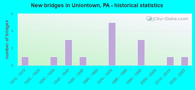
- New bridges - historical statistics
- 11910-1919
- 11930-1939
- 31940-1949
- 11950-1959
- 51970-1979
- 31990-1999
- 12010-2019
- 12020-2022
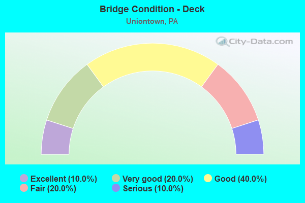
- Bridge Condition - Deck
- 10.0%Excellent
- 20.0%Very good
- 40.0%Good
- 20.0%Fair
- 10.0%Serious
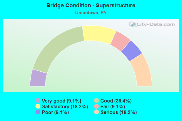
- Bridge Condition - Superstructure
- 9.1%Very good
- 36.4%Good
- 18.2%Satisfactory
- 9.1%Fair
- 9.1%Poor
- 18.2%Serious
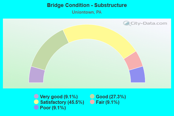
- Bridge Condition - Substructure
- 9.1%Very good
- 27.3%Good
- 45.5%Satisfactory
- 9.1%Fair
- 9.1%Poor
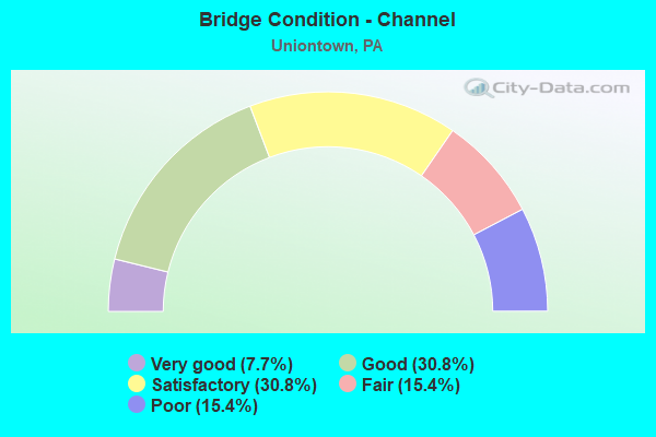
- Bridge Condition - Channel
- 7.7%Very good
- 30.8%Good
- 30.8%Satisfactory
- 15.4%Fair
- 15.4%Poor
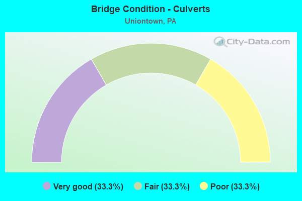
- Bridge Condition - Culverts
- 33.3%Very good
- 33.3%Fair
- 33.3%Poor
Find on map >> Show street view
Structure Number: 1716, Location: 1/2 MI.N.W.OF SR 3015 (Lat: 40.277561, Lng: -79.975717), Route carried "on" structure: State highway , Year Built: 1974, Year Reconstructed: 2016, Status: Open, Structure Length: 1.46m (4.79ft), Average Daily Traffic: 595 (year 2022), Truck Traffic: 3%, Average Future Daily Traffic: 1,183 (year 2032), Design Load: HS 20, Features Intersected: PINEY FORK CREEK, Facility Carried by Structure: PINEY FORK RD
Minimum Vertical Clearance: 30+ m (98+ ft), Kilometerpoint: 1.881, Lanes on structure: 2, Owner: State Highway Agency, Approaching Roadway Width: 7.9m (25.9ft), Skew: 3 degrees, Material/Design: Prestressed concrete, Design/Construction: Box Beam or Girders - Multiple, Number Of Spans In Main Unit: 1, Length of Maximum Span: 13.4m (44.0ft), Curb or Sidewalk Widths: Left: 0.2m (0.7ft), Right: 0.2m (0.7ft), Curb-To-Curb Width: 7.9m (25.9ft), Out-to-Out Width: 9.1m (29.9ft)
Condition: Deck: Very good, Superstructure: Satisfactory, Substructure: Satisfactory, Channel: Satisfactory, Inventory Rating: 54.4 metric tons, Method Used To Determine Inventory Rating: Load Factor (LF), Structural Evaluation: Equal to present minimum criteria, Deck Geometry: Somewhat better than minimum adequacy, Waterway Adequacy: Better than present minimum criteria, Approach Roadway Alignment: Equal to present desirable criteria, Length Of Structure Improvement: 1.30m (4.27ft), Designated Inspection Frequency: Every 24 months, Inspection Date: May 2021, Wearing Surface/Protective System: Wearing Surface: Bituminous
Find on map >> Show street view
Structure Number: 16545, Location: SOUTH UNION TOWNSHIP (Lat: 39.902275, Lng: -79.746022), Route carried "on" structure: State highway 21, Year Built: 1971, Year Reconstructed: 2016, Status: Open, Structure Length: 11.40m (37.40ft), Average Daily Traffic: 9,310 (year 2021), Truck Traffic: 6%, Average Future Daily Traffic: 13,310 (year 2032), Design Load: HL 93, Features Intersected: SR 0040
Minimum Vertical Clearance: 30+ m (98+ ft), Kilometerpoint: 17.775, Lanes on structure: 2, Lanes under structure: 8, Base Highway Network: Yes, Owner: State Highway Agency, Approaching Roadway Width: 13.4m (44.0ft), Skew: 3 degrees, Material/Design: Prestressed concrete continuous, Design/Construction: Stringer/Multi-beam, Number Of Spans In Main Unit: 4, Length of Maximum Span: 29.9m (98.1ft), Curb or Sidewalk Widths: Left: 0.2m (0.7ft), Right: 0.2m (0.7ft), Curb-To-Curb Width: 13.4m (44.0ft), Out-to-Out Width: 14.4m (47.2ft)
Condition: Deck: Excellent, Superstructure: Good, Substructure: Good, Operating Rating: 71.7 metric tons, Method Used To Determine Operating Rating: Assigned ratings based on Load and Resistance Factor Design (LRFD) reported in metric tons, Inventory Rating: 30.8 metric tons, Method Used To Determine Inventory Rating: Assigned ratings based on Load and Resistance Factor Design (LRFD) reported in metric tons, Structural Evaluation: Better than present minimum criteria, Deck Geometry: Equal to present minimum criteria, Underclear: Better than present minimum criteria, Approach Roadway Alignment: Equal to present desirable criteria, Length Of Structure Improvement: 12.10m (39.70ft), Designated Inspection Frequency: Every 24 months, Inspection Date: October 2020, Bridge Improvement Cost: $84,000, Roadway Improvement Cost: $246,000, Total Project Cost: $1,128,000, Deck Structure Type: Concrete Cast-file-Place, Wearing Surface/Protective System: Wearing Surface: Monolithic Concrete, Deck Protection: Epoxy Coated Reinforcing
Find on map >> Show street view
Structure Number: 17058, Location: CITY OF UNIONTOWN (Lat: 39.900297, Lng: -79.730697), Route carried "on" structure: US 40B, Year Built: 1942, Status: Open, Structure Length: 0.94m (3.08ft), Average Daily Traffic: 7,193 (year 2022), Truck Traffic: 7%, Average Future Daily Traffic: 9,697 (year 2032), Design Load: HS 20, Features Intersected: COAL LICK RUN, Facility Carried by Structure: SR 2040; US 40 BUS
Minimum Vertical Clearance: 30+ m (98+ ft), Kilometerpoint: 0.940, Lanes on structure: 3, Base Highway Network: Yes, Owner: State Highway Agency, Approaching Roadway Width: 11.0m (36.1ft), Skew: 3 degrees, Material/Design: Concrete, Design/Construction: Tee Beam, Number Of Spans In Main Unit: 1, Length of Maximum Span: 8.5m (27.9ft), Curb or Sidewalk Widths: Left: 1.2m (3.9ft), Right: 2.1m (6.9ft), Curb-To-Curb Width: 11.0m (36.1ft), Out-to-Out Width: 15.2m (49.9ft)
Condition: Deck: Fair, Superstructure: Fair, Substructure: Fair, Channel: Satisfactory, Operating Rating: 64.4 metric tons, Method Used To Determine Operating Rating: Allowable Stress (AS), Inventory Rating: 37.2 metric tons, Method Used To Determine Inventory Rating: Allowable Stress (AS), Structural Evaluation: Somewhat better than minimum adequacy, Deck Geometry: High priority of replacement, Waterway Adequacy: Superior to present desirable criteria, Approach Roadway Alignment: Equal to present desirable criteria, Length Of Structure Improvement: 1.60m (5.25ft), Designated Inspection Frequency: Every 24 months, Inspection Date: Febuary 2021, Bridge Improvement Cost: $6,000, Roadway Improvement Cost: $16,000, Total Project Cost: $75,000, Deck Structure Type: Concrete Cast-file-Place, Wearing Surface/Protective System: Wearing Surface: Bituminous
Find on map >> Show street view
Structure Number: 17059, Location: CITY OF UNIONTOWN (Lat: 39.900000, Lng: -79.719967), Route carried "on" structure: US 40B, Year Built: 1940, Status: Open, Structure Length: 1.37m (4.49ft), Average Daily Traffic: 2,167 (year 2021), Truck Traffic: 3%, Average Future Daily Traffic: 7,473 (year 2032), Design Load: HS 20, Features Intersected: REDSTONE CREEK, Facility Carried by Structure: SR 2040; US 40 BUS
Minimum Vertical Clearance: 30+ m (98+ ft), Kilometerpoint: 1.558, Lanes on structure: 2, Base Highway Network: Yes, Owner: State Highway Agency, Approaching Roadway Width: 9.1m (29.9ft), Material/Design: Masonry, Design/Construction: Arch - Deck, Number Of Spans In Main Unit: 1, Length of Maximum Span: 13.7m (44.9ft), Curb or Sidewalk Widths: Left: 2.6m (8.5ft), Right: 2.6m (8.5ft), Curb-To-Curb Width: 9.3m (30.5ft), Out-to-Out Width: 13.0m (42.7ft)
Condition: Superstructure: Poor, Substructure: Poor, Channel: Poor, Operating Rating: 49.9 metric tons, Method Used To Determine Operating Rating: Field evaluation and documented engineering judgment, Inventory Rating: 29.9 metric tons, Method Used To Determine Inventory Rating: Field evaluation and documented engineering judgment, Structural Evaluation: Meets minimum limits, Deck Geometry: Meets minimum limits, Waterway Adequacy: Superior to present desirable criteria, Approach Roadway Alignment: Equal to present desirable criteria, Length Of Structure Improvement: 1.40m (4.59ft), Designated Inspection Frequency: Every 24 months, Other Special Inspection Frequency: Every 12 months, Inspection Date: March 2021, Other Special Inspection Date: March 2021, Bridge Improvement Cost: $38,000, Roadway Improvement Cost: $112,000, Total Project Cost: $513,000
Find on map >> Show street view
Structure Number: 1706, Location: CITY OF UNIONTOWN (Lat: 39.897725, Lng: -79.723789), Route carried "on" structure: US 40B, Year Built: 1940, Status: Open, Structure Length: 1.52m (4.99ft), Average Daily Traffic: 8,260 (year 2020), Truck Traffic: 10%, Average Future Daily Traffic: 11,530 (year 2032), Design Load: HS 20, Features Intersected: REDSTONE CREEK, Facility Carried by Structure: SR 2040; US 40 BUS
Minimum Vertical Clearance: 30+ m (98+ ft), Kilometerpoint: 1.611, Lanes on structure: 2, Base Highway Network: Yes, Owner: State Highway Agency, Approaching Roadway Width: 11.6m (38.1ft), Material/Design: Steel, Design/Construction: Stringer/Multi-beam, Number Of Spans In Main Unit: 1, Length of Maximum Span: 14.6m (47.9ft), Curb or Sidewalk Widths: Left: 3.0m (9.8ft), Right: 3.0m (9.8ft), Curb-To-Curb Width: 11.6m (38.1ft), Out-to-Out Width: 17.7m (58.1ft)
Condition: Deck: Good, Superstructure: Satisfactory, Substructure: Satisfactory, Channel: Fair, Operating Rating: 46.3 metric tons, Method Used To Determine Operating Rating: Load Factor (LF), Inventory Rating: 27.2 metric tons, Method Used To Determine Inventory Rating: Load Factor (LF), Structural Evaluation: Equal to present minimum criteria, Deck Geometry: Better than present minimum criteria, Waterway Adequacy: Better than present minimum criteria, Approach Roadway Alignment: Equal to present desirable criteria, Length Of Structure Improvement: 2.10m (6.89ft), Designated Inspection Frequency: Every 24 months, Inspection Date: Febuary 2021, Bridge Improvement Cost: $9,000, Roadway Improvement Cost: $26,000, Total Project Cost: $120,000, Deck Structure Type: Concrete Cast-file-Place, Wearing Surface/Protective System: Wearing Surface: Bituminous
Find on map >> Show street view
Structure Number: 17157, Location: DUNBAR STREET (Lat: 39.896367, Lng: -79.723264), Route carried "on" structure: City street D0BR, Year Built: 1997, Status: Open, Structure Length: 1.34m (4.40ft), Average Daily Traffic: 3,500 (year 2006), Truck Traffic: 5%, Average Future Daily Traffic: 3,500 (year 2023), Design Load: HS 25 or greater, Features Intersected: REDSTONE CREEK, Facility Carried by Structure: DUNBAR STREET
Minimum Vertical Clearance: 30+ m (98+ ft), Kilometerpoint: 0.000, Lanes on structure: 2, Owner: City or Municipal Highway Agency, Approaching Roadway Width: 7.6m (24.9ft), Skew: 4 degrees, Material/Design: Prestressed concrete, Design/Construction: Box Beam or Girders - Single/Spread, Number Of Spans In Main Unit: 1, Length of Maximum Span: 12.8m (42.0ft), Curb or Sidewalk Widths: Left: 0.2m (0.7ft), Right: 1.5m (4.9ft), Curb-To-Curb Width: 7.5m (24.6ft), Out-to-Out Width: 9.8m (32.2ft)
Condition: Deck: Good, Superstructure: Good, Substructure: Good, Channel: Good, Operating Rating: 77.1 metric tons, Method Used To Determine Operating Rating: Load Factor (LF), Inventory Rating: 45.4 metric tons, Method Used To Determine Inventory Rating: Load Factor (LF), Structural Evaluation: Better than present minimum criteria, Deck Geometry: High priority of replacement, Waterway Adequacy: Better than present minimum criteria, Approach Roadway Alignment: Equal to present desirable criteria, Length Of Structure Improvement: 1.20m (3.94ft), Designated Inspection Frequency: Every 24 months, Inspection Date: April 2020, Bridge Improvement Cost: $4,000, Roadway Improvement Cost: $12,000, Total Project Cost: $56,000, Deck Structure Type: Concrete Cast-file-Place, Wearing Surface/Protective System: Wearing Surface: Monolithic Concrete, Deck Protection: Epoxy Coated Reinforcing
Find on map >> Show street view
Structure Number: 17158, Location: 400' SOUTH OF CHURCH ST. (Lat: 39.899178, Lng: -79.721492), Route carried "on" structure: City street JEFF, Year Built: 1971, Status: Posted for load, Structure Length: 1.65m (5.41ft), Average Daily Traffic: 4,700 (year 2004), Average Future Daily Traffic: 4,700 (year 2024), Design Load: HS 20, Features Intersected: REDSTONE CREEK
Minimum Vertical Clearance: 30+ m (98+ ft), Kilometerpoint: 0.000, Lanes on structure: 2, Owner: City or Municipal Highway Agency, Approaching Roadway Width: 7.6m (24.9ft), Skew: 3 degrees, Material/Design: Prestressed concrete, Design/Construction: Box Beam or Girders - Multiple, Number Of Spans In Main Unit: 1, Length of Maximum Span: 15.8m (51.8ft), Curb or Sidewalk Widths: Left: 1.5m (4.9ft), Right: 1.5m (4.9ft), Curb-To-Curb Width: 7.5m (24.6ft), Out-to-Out Width: 11.1m (36.4ft)
Condition: Deck: Serious, Superstructure: Serious, Substructure: Satisfactory, Channel: Satisfactory, Operating Rating: 41.7 metric tons, Method Used To Determine Operating Rating: Load Factor (LF), Inventory Rating: 17.2 metric tons, Method Used To Determine Inventory Rating: Load Factor (LF), Structural Evaluation: High priority of corrective action, Deck Geometry: High priority of replacement, Waterway Adequacy: Better than present minimum criteria, Approach Roadway Alignment: Somewhat better than minimum adequacy, Length Of Structure Improvement: 2.00m (6.56ft), Designated Inspection Frequency: Every 24 months, Other Special Inspection Frequency: Every 6 months, Inspection Date: April 2020, Other Special Inspection Date: April 2021, Bridge Improvement Cost: $8,000, Roadway Improvement Cost: $25,000, Total Project Cost: $113,000, Deck Structure Type: Concrete Cast-file-Place, Wearing Surface/Protective System: Wearing Surface: Bituminous
Find on map >> Show street view
Structure Number: 17159, Location: 400' FROM PENN ST. INTER. (Lat: 39.903228, Lng: -79.725878), Route carried "on" structure: City street BE00, Year Built: 1994, Status: Open, Structure Length: 1.37m (4.49ft), Average Daily Traffic: 2,500 (year 2006), Truck Traffic: 1%, Average Future Daily Traffic: 3,000 (year 2028), Design Load: HS 25 or greater, Features Intersected: REDSTONE CREEK, Facility Carried by Structure: N BEESON AVENUE
Minimum Vertical Clearance: 30+ m (98+ ft), Kilometerpoint: 0.000, Lanes on structure: 2, Owner: City or Municipal Highway Agency, Approaching Roadway Width: 7.9m (25.9ft), Skew: 1 degrees, Material/Design: Prestressed concrete, Design/Construction: Box Beam or Girders - Single/Spread, Number Of Spans In Main Unit: 1, Length of Maximum Span: 13.7m (44.9ft), Curb or Sidewalk Widths: Left: 1.5m (4.9ft), Right: 1.5m (4.9ft), Curb-To-Curb Width: 7.9m (25.9ft), Out-to-Out Width: 11.6m (38.1ft)
Condition: Deck: Good, Superstructure: Good, Substructure: Satisfactory, Channel: Good, Operating Rating: 88.0 metric tons, Method Used To Determine Operating Rating: Load Factor (LF), Inventory Rating: 45.4 metric tons, Method Used To Determine Inventory Rating: Load Factor (LF), Structural Evaluation: Equal to present minimum criteria, Deck Geometry: High priority of corrective action, Waterway Adequacy: Better than present minimum criteria, Approach Roadway Alignment: Equal to present desirable criteria, Length Of Structure Improvement: 1.50m (4.92ft), Designated Inspection Frequency: Every 24 months, Inspection Date: April 2020, Bridge Improvement Cost: $9,000, Roadway Improvement Cost: $27,000, Total Project Cost: $123,000, Deck Structure Type: Concrete Cast-file-Place, Wearing Surface/Protective System: Wearing Surface: Monolithic Concrete, Deck Protection: Epoxy Coated Reinforcing
Find on map >> Show street view
Structure Number: 1716, Location: 200' NORTH OF PENN ST (Lat: 39.902961, Lng: -79.724022), Route carried "on" structure: City street G0L, Year Built: 1953, Status: Posted for load, Structure Length: 1.58m (5.18ft), Average Daily Traffic: 11,880 (year 2013), Average Future Daily Traffic: 11,880 (year 2033), Design Load: HS 20, Features Intersected: REDSTONE CREEK, Facility Carried by Structure: N. GALLATIN AVE
Minimum Vertical Clearance: 30+ m (98+ ft), Kilometerpoint: 0.000, Lanes on structure: 2, Owner: City or Municipal Highway Agency, Approaching Roadway Width: 12.2m (40.0ft), Material/Design: Steel, Design/Construction: Stringer/Multi-beam, Number Of Spans In Main Unit: 1, Length of Maximum Span: 15.2m (49.9ft), Curb or Sidewalk Widths: Left: 2.4m (7.9ft), Right: 2.4m (7.9ft), Curb-To-Curb Width: 7.6m (24.9ft), Out-to-Out Width: 17.9m (58.7ft)
Condition: Deck: Fair, Superstructure: Serious, Substructure: Satisfactory, Channel: Satisfactory, Operating Rating: 47.2 metric tons, Method Used To Determine Operating Rating: Load Factor (LF), Inventory Rating: 28.1 metric tons, Method Used To Determine Inventory Rating: Load Factor (LF), Structural Evaluation: High priority of corrective action, Deck Geometry: High priority of replacement, Waterway Adequacy: Better than present minimum criteria, Approach Roadway Alignment: Equal to present desirable criteria, Length Of Structure Improvement: 2.30m (7.55ft), Designated Inspection Frequency: Every 24 months, Other Special Inspection Frequency: Every 6 months, Inspection Date: April 2020, Other Special Inspection Date: April 2021, Bridge Improvement Cost: $17,000, Roadway Improvement Cost: $50,000, Total Project Cost: $228,000, Deck Structure Type: Concrete Cast-file-Place, Wearing Surface/Protective System: Wearing Surface: Bituminous
Find on map >> Show street view
Structure Number: 17161, Location: 300' EAST OF GALLATIN AVE (Lat: 39.902406, Lng: -79.722875), Route carried "on" structure: City street E00, Year Built: 1930, Status: Open, Structure Length: 1.71m (5.61ft), Average Daily Traffic: 7,000 (year 2006), Truck Traffic: 5%, Average Future Daily Traffic: 7,000 (year 2023), Features Intersected: REDSTONE CREEK, Facility Carried by Structure: PENN STREET
Minimum Vertical Clearance: 30+ m (98+ ft), Kilometerpoint: 0.000, Lanes on structure: 2, Owner: City or Municipal Highway Agency, Approaching Roadway Width: 7.9m (25.9ft), Skew: 2 degrees, Material/Design: Concrete, Design/Construction: Culvert, Number Of Spans In Main Unit: 1, Length of Maximum Span: 13.4m (44.0ft), Curb or Sidewalk Widths: Left: 2.1m (6.9ft), Right: 1.8m (5.9ft)
Condition: Channel: Fair, Culverts: Fair, Operating Rating: 49.0 metric tons, Method Used To Determine Operating Rating: Field evaluation and documented engineering judgment, Inventory Rating: 32.7 metric tons, Method Used To Determine Inventory Rating: Field evaluation and documented engineering judgment, Structural Evaluation: Somewhat better than minimum adequacy, Waterway Adequacy: Equal to present minimum criteria, Approach Roadway Alignment: Equal to present desirable criteria, Length Of Structure Improvement: 1.70m (5.58ft), Designated Inspection Frequency: Every 24 months, Inspection Date: April 2020, Bridge Improvement Cost: $15,000, Roadway Improvement Cost: $43,000, Total Project Cost: $199,000
Find on map >> Show street view
Structure Number: 17162, Location: 700' WEST OF FAYETTE ST. (Lat: 39.895375, Lng: -79.722233), Route carried "on" structure: City street V, Year Built: 1994, Status: Open, Structure Length: 1.07m (3.51ft), Average Daily Traffic: 1,700 (year 2015), Truck Traffic: 5%, Average Future Daily Traffic: 1,700 (year 2023), Design Load: HS 25 or greater, Features Intersected: REDSTONE CREEK
Minimum Vertical Clearance: 30+ m (98+ ft), Kilometerpoint: 0.000, Lanes on structure: 2, Owner: City or Municipal Highway Agency, Approaching Roadway Width: 9.1m (29.9ft), Skew: 2 degrees, Material/Design: Prestressed concrete, Design/Construction: Box Beam or Girders - Single/Spread, Number Of Spans In Main Unit: 1, Length of Maximum Span: 10.7m (35.1ft), Curb or Sidewalk Widths: Left: 1.5m (4.9ft), Right: 1.5m (4.9ft), Curb-To-Curb Width: 9.1m (29.9ft), Out-to-Out Width: 12.8m (42.0ft)
Condition: Deck: Good, Superstructure: Good, Substructure: Good, Channel: Good, Operating Rating: 80.7 metric tons, Method Used To Determine Operating Rating: Load Factor (LF), Inventory Rating: 42.6 metric tons, Method Used To Determine Inventory Rating: Load Factor (LF), Structural Evaluation: Better than present minimum criteria, Deck Geometry: Somewhat better than minimum adequacy, Waterway Adequacy: Better than present minimum criteria, Approach Roadway Alignment: Equal to present desirable criteria, Length Of Structure Improvement: 1.00m (3.28ft), Designated Inspection Frequency: Every 24 months, Inspection Date: April 2020, Bridge Improvement Cost: $6,000, Roadway Improvement Cost: $16,000, Total Project Cost: $75,000, Deck Structure Type: Concrete Cast-file-Place, Wearing Surface/Protective System: Wearing Surface: Monolithic Concrete, Deck Protection: Epoxy Coated Reinforcing
Find on map >> Show street view
Structure Number: 17163, Location: 500' S OF MT VERNON AVE (Lat: 39.897861, Lng: -79.732447), Route carried "on" structure: City street BERK, Year Built: 1913, Status: Open, Structure Length: 1.22m (4.00ft), Average Daily Traffic: 200 (year 2004), Truck Traffic: 5%, Average Future Daily Traffic: 11,000 (year 2023), Design Load: H 15, Features Intersected: COAL LICK RUN
Minimum Vertical Clearance: 30+ m (98+ ft), Kilometerpoint: 0.000, Lanes on structure: 2, Owner: City or Municipal Highway Agency, Approaching Roadway Width: 7.9m (25.9ft), Skew: 3 degrees, Material/Design: Concrete, Design/Construction: Culvert, Number Of Spans In Main Unit: 1, Length of Maximum Span: 6.7m (22.0ft), Curb or Sidewalk Widths: Left: 1.5m (4.9ft), Right: 1.5m (4.9ft), Out-to-Out Width: 15.2m (49.9ft)
Condition: Channel: Poor, Culverts: Poor, Operating Rating: 49.0 metric tons, Method Used To Determine Operating Rating: Field evaluation and documented engineering judgment, Inventory Rating: 32.7 metric tons, Method Used To Determine Inventory Rating: Field evaluation and documented engineering judgment, Structural Evaluation: Meets minimum limits, Waterway Adequacy: Better than present minimum criteria, Approach Roadway Alignment: Equal to present desirable criteria, Length Of Structure Improvement: 1.20m (3.94ft), Designated Inspection Frequency: Every 24 months, Inspection Date: April 2020, Bridge Improvement Cost: $13,000, Roadway Improvement Cost: $37,000, Total Project Cost: $171,000
Find on map >> Show street view
Structure Number: 52779, Location: 0.8 mi S from SR 0119 (Lat: 39.904072, Lng: -79.726922), Route carried "on" structure: State highway 51, Year Built: 2015, Status: Open, Structure Length: 1.13m (3.71ft), Average Daily Traffic: 14,004 (year 2022), Truck Traffic: 5%, Average Future Daily Traffic: 10,759 (year 2020), Design Load: HL 93, Features Intersected: Coal Lick Run
Minimum Vertical Clearance: 30+ m (98+ ft), Kilometerpoint: 0.000, Lanes on structure: 3, Base Highway Network: Yes, Owner: State Highway Agency, Approaching Roadway Width: 9.1m (29.9ft), Material/Design: Prestressed concrete, Design/Construction: Box Beam or Girders - Single/Spread, Number Of Spans In Main Unit: 1, Length of Maximum Span: 11.0m (36.1ft), Curb or Sidewalk Widths: Left: 2.0m (6.6ft), Right: 0.2m (0.7ft), Curb-To-Curb Width: 9.1m (29.9ft), Out-to-Out Width: 11.7m (38.4ft)
Condition: Deck: Very good, Superstructure: Very good, Substructure: Very good, Channel: Good, Operating Rating: 51.8 metric tons, Method Used To Determine Operating Rating: Assigned ratings based on Load and Resistance Factor Design (LRFD) reported by rating factor (RF) using HL93 loadings, Inventory Rating: 39.9 metric tons, Method Used To Determine Inventory Rating: Assigned ratings based on Load and Resistance Factor Design (LRFD) reported by rating factor (RF) using HL93 loadings, Structural Evaluation: Equal to present desirable criteria, Deck Geometry: High priority of replacement, Waterway Adequacy: Better than present minimum criteria, Approach Roadway Alignment: Equal to present desirable criteria, Designated Inspection Frequency: Every 48 months, Inspection Date: December 2020, Deck Structure Type: Concrete Cast-file-Place, Wearing Surface/Protective System: Wearing Surface: Monolithic Concrete, Deck Protection: Epoxy Coated Reinforcing
Find on map >> Show street view
Structure Number: 67838, Location: CITY OF UNIONTOWN (Lat: 39.900764, Lng: -79.730711), Route carried "on" structure: US 40B, Year Built: 2020, Status: Open, Structure Length: 0.85m (2.79ft), Average Daily Traffic: 3,812 (year 2022), Truck Traffic: 2%, Average Future Daily Traffic: 4,500 (year 2042), Design Load: HL 93, Features Intersected: Coal Lick Run, Facility Carried by Structure: SR 2040; US 40 BUS
Minimum Vertical Clearance: 30+ m (98+ ft), Kilometerpoint: 0.937, Lanes on structure: 2, Base Highway Network: Yes, Owner: State Highway Agency, Approaching Roadway Width: 8.5m (27.9ft), Material/Design: Concrete, Design/Construction: Culvert, Number Of Spans In Main Unit: 1, Length of Maximum Span: 8.5m (27.9ft)
Condition: Channel: Very good, Culverts: Very good, Operating Rating: 48.6 metric tons, Method Used To Determine Operating Rating: Assigned ratings based on Load and Resistance Factor Design (LRFD) reported by rating factor (RF) using HL93 loadings, Inventory Rating: 35.6 metric tons, Method Used To Determine Inventory Rating: Assigned ratings based on Load and Resistance Factor Design (LRFD) reported by rating factor (RF) using HL93 loadings, Structural Evaluation: Equal to present desirable criteria, Waterway Adequacy: Superior to present desirable criteria, Approach Roadway Alignment: Equal to present desirable criteria, Designated Inspection Frequency: Every 24 months, Inspection Date: Febuary 2021
Find on map >> Show street view
Structure Number: 16545, Location: SOUTH UNION TOWNSHIP (Lat: 39.902275, Lng: -79.746022), Route carried "under" structure: US 40, Year Built: 1971, Structure Length: 0. m, Average Daily Traffic: 13,851 (year 2022), Truck Traffic: 9%, Features Intersected: SR 0040, Facility Carried by Structure: SR 0021
Minimum Vertical Clearance: 9.45m (31.00ft), Kilometerpoint: 19.199, Lanes on structure: 2, Lanes under structure: 4, Material/Design: Prestressed concrete continuous, Design/Construction: Stringer/Multi-beam, Length of Maximum Span: 29.9m (98.1ft)
Find on map >> Show street view
Structure Number: 16545, Location: SOUTH UNION TOWNSHIP (Lat: 39.902275, Lng: -79.746022), Route carried "under" structure: US 40, Year Built: 1971, Structure Length: 0. m, Average Daily Traffic: 14,805 (year 2022), Truck Traffic: 9%, Features Intersected: SR 0040, Facility Carried by Structure: SR 0021
Minimum Vertical Clearance: 9.45m (31.00ft), Kilometerpoint: 19.179, Lanes on structure: 2, Lanes under structure: 4, Material/Design: Prestressed concrete continuous, Design/Construction: Stringer/Multi-beam, Length of Maximum Span: 29.9m (98.1ft)