Bridge Statistics for University City, Missouri (MO)
Condition, Traffic, Stress, Structural Evaluation, Project Costs
- National Bridge Inventory (NBI) Statistics
- 44Number of bridges
- 397ft / 121mTotal length
- $3,286,000Total costs
- 992,076Total average daily traffic
- 65,357Total average daily truck traffic
- National Bridge Inventory (NBI) Registered Bridges for University City
- No street view available for this location
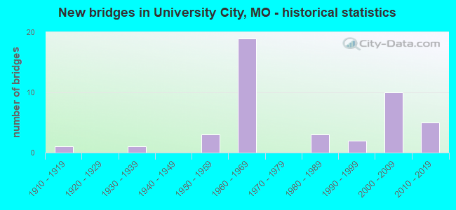
- New bridges - historical statistics
- 11910-1919
- 11930-1939
- 31950-1959
- 191960-1969
- 31980-1989
- 21990-1999
- 102000-2009
- 52010-2019
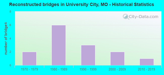
- Reconstructed bridges - Historical Statistics
- 21970-1979
- 61980-1989
- 31990-1999
- 22000-2009
- 12010-2019
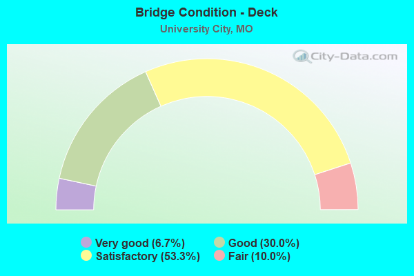
- Bridge Condition - Deck
- 6.7%Very good
- 30.0%Good
- 53.3%Satisfactory
- 10.0%Fair
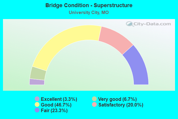
- Bridge Condition - Superstructure
- 3.3%Excellent
- 6.7%Very good
- 46.7%Good
- 20.0%Satisfactory
- 23.3%Fair
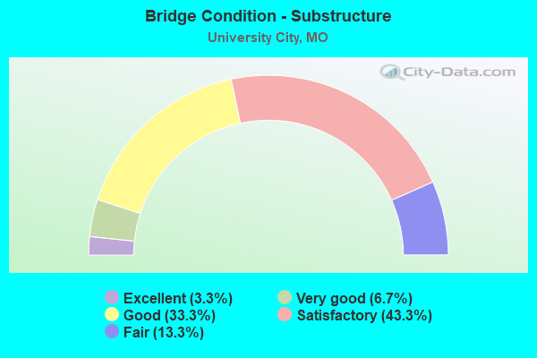
- Bridge Condition - Substructure
- 3.3%Excellent
- 6.7%Very good
- 33.3%Good
- 43.3%Satisfactory
- 13.3%Fair
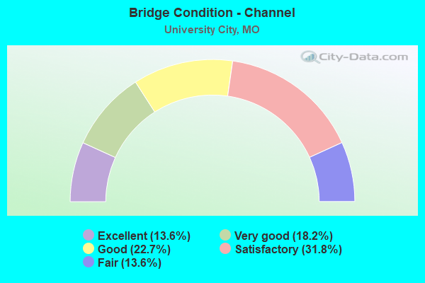
- Bridge Condition - Channel
- 13.6%Excellent
- 18.2%Very good
- 22.7%Good
- 31.8%Satisfactory
- 13.6%Fair
Find on map >> Show street view
Structure Number: 1559, Location: S 2 T 43 N R 17 W (Lat: 38.510617, Lng: -92.754742), Route carried "on" structure: State highway HH, Year Built: 1966, Year Reconstructed: 2009, Status: Open, Structure Length: 3.23m (10.60ft), Average Daily Traffic: 536 (year 2021), Truck Traffic: 16%, Average Future Daily Traffic: 992 (year 2041), Design Load: H 15, Features Intersected: SMITH FORK CREEK
Minimum Vertical Clearance: 30+ m (98+ ft), Kilometerpoint: 4.505, Lanes on structure: 2, Owner: State Highway Agency, Approaching Roadway Width: 8.5m (27.9ft), Material/Design: Steel continuous, Design/Construction: Stringer/Multi-beam, Number Of Spans In Main Unit: 3, Length of Maximum Span: 12.5m (41.0ft), Curb-To-Curb Width: 7.9m (25.9ft), Out-to-Out Width: 8.7m (28.5ft)
Condition: Deck: Very good, Superstructure: Satisfactory, Substructure: Good, Channel: Good, Operating Rating: 37.8 metric tons, Method Used To Determine Operating Rating: Load Factor (LF), Inventory Rating: 22.5 metric tons, Method Used To Determine Inventory Rating: Load Factor (LF), Structural Evaluation: Equal to present minimum criteria, Deck Geometry: Somewhat better than minimum adequacy, Waterway Adequacy: Equal to present minimum criteria, Approach Roadway Alignment: Equal to present desirable criteria, Designated Inspection Frequency: Every 24 months, Inspection Date: December 2021, Deck Structure Type: Concrete Cast-file-Place, Wearing Surface/Protective System: Wearing Surface: Monolithic Concrete, Deck Protection: Epoxy Coated Reinforcing
Find on map >> Show street view
Structure Number: 1559, Location: S 3 T 45 N R 6 E (Lat: 38.666392, Lng: -90.332297), Route carried "on" structure: County highway , Year Built: 1967, Year Reconstructed: 2003, Status: Posted for load, Structure Length: 2.35m (7.71ft), Average Daily Traffic: 9,482 (year 2020), Truck Traffic: 2%, Average Future Daily Traffic: 12,801 (year 2040), Design Load: HS 25 or greater, Features Intersected: RVR DES PERES, Facility Carried by Structure: HANLEY RD
Minimum Vertical Clearance: 30+ m (98+ ft), Kilometerpoint: 0.000, Lanes on structure: 4, Owner: County Highway Agency, Approaching Roadway Width: 13.1m (43.0ft), Skew: 10 degrees, Material/Design: Prestressed concrete, Design/Construction: Box Beam or Girders - Multiple, Number Of Spans In Main Unit: 2, Length of Maximum Span: 11.3m (37.1ft), Curb or Sidewalk Widths: Left: 1.7m (5.6ft), Right: 1.7m (5.6ft), Curb-To-Curb Width: 13.1m (43.0ft), Out-to-Out Width: 16.5m (54.1ft)
Condition: Deck: Satisfactory, Superstructure: Satisfactory, Substructure: Fair, Channel: Satisfactory, Operating Rating: 63.9 metric tons, Method Used To Determine Operating Rating: Load Factor (LF), Inventory Rating: 37.8 metric tons, Method Used To Determine Inventory Rating: Load Factor (LF), Structural Evaluation: Somewhat better than minimum adequacy, Deck Geometry: High priority of replacement, Waterway Adequacy: Equal to present desirable criteria, Approach Roadway Alignment: Equal to present desirable criteria, Length Of Structure Improvement: 0.32m (1.05ft), Designated Inspection Frequency: Every 24 months, Inspection Date: March 2021, Bridge Improvement Cost: $523,000, Roadway Improvement Cost: $52,000, Total Project Cost: $784,000 ( Estimate for 2022), Deck Structure Type: Other, Wearing Surface/Protective System: Wearing Surface: Bituminous, Membrane: Other
Find on map >> Show street view
Structure Number: 15593, Location: S 3 T 45 N R 6 E (Lat: 38.670211, Lng: -90.325889), Route carried "on" structure: County highway , Year Built: 1987, Status: Posted for load, Structure Length: 2.50m (8.20ft), Average Daily Traffic: 6,620 (year 2020), Truck Traffic: 5%, Average Future Daily Traffic: 8,937 (year 2040), Design Load: HS 20+Mod, Features Intersected: RVR DES PERES, Facility Carried by Structure: MIDLAND BLVD
Minimum Vertical Clearance: 30+ m (98+ ft), Kilometerpoint: 0.000, Lanes on structure: 2, Owner: County Highway Agency, Approaching Roadway Width: 17.7m (58.1ft), Skew: 10 degrees, Material/Design: Prestressed concrete, Design/Construction: Stringer/Multi-beam, Number Of Spans In Main Unit: 1, Length of Maximum Span: 23.5m (77.1ft), Curb or Sidewalk Widths: Left: 1.8m (5.9ft), Right: 1.8m (5.9ft), Curb-To-Curb Width: 17.7m (58.1ft), Out-to-Out Width: 19.3m (63.3ft)
Condition: Deck: Satisfactory, Superstructure: Good, Substructure: Satisfactory, Channel: Good, Operating Rating: 38.7 metric tons, Method Used To Determine Operating Rating: Allowable Stress (AS), Inventory Rating: 22.5 metric tons, Method Used To Determine Inventory Rating: Allowable Stress (AS), Structural Evaluation: Somewhat better than minimum adequacy, Deck Geometry: Superior to present desirable criteria, Waterway Adequacy: Superior to present desirable criteria, Approach Roadway Alignment: Better than present minimum criteria, Designated Inspection Frequency: Every 24 months, Inspection Date: March 2021, Deck Structure Type: Concrete Cast-file-Place, Wearing Surface/Protective System: Wearing Surface: Monolithic Concrete
Find on map >> Show street view
Structure Number: 15597, Location: S 2 T 45 N R 6 E (Lat: 38.663019, Lng: -90.316800), Route carried "on" structure: County highway , Year Built: 1981, Status: Posted for load, Structure Length: 3.35m (10.99ft), Average Daily Traffic: 4,674 (year 2020), Truck Traffic: 5%, Average Future Daily Traffic: 6,310 (year 2040), Design Load: HS 20, Features Intersected: RVR DES PERES, Facility Carried by Structure: VERNON AVE
Minimum Vertical Clearance: 30+ m (98+ ft), Kilometerpoint: 0.000, Lanes on structure: 4, Owner: County Highway Agency, Approaching Roadway Width: 15.2m (49.9ft), Material/Design: Prestressed concrete continuous, Design/Construction: Stringer/Multi-beam, Number Of Spans In Main Unit: 2, Length of Maximum Span: 15.8m (51.8ft), Curb or Sidewalk Widths: Left: 1.5m (4.9ft), Right: 1.5m (4.9ft), Curb-To-Curb Width: 16.2m (53.1ft), Out-to-Out Width: 17.8m (58.4ft)
Condition: Deck: Satisfactory, Superstructure: Good, Substructure: Satisfactory, Channel: Satisfactory, Operating Rating: 59.4 metric tons, Method Used To Determine Operating Rating: Allowable Stress (AS), Inventory Rating: 31.5 metric tons, Method Used To Determine Inventory Rating: Allowable Stress (AS), Structural Evaluation: Equal to present minimum criteria, Deck Geometry: Meets minimum limits, Waterway Adequacy: Superior to present desirable criteria, Approach Roadway Alignment: Equal to present desirable criteria, Designated Inspection Frequency: Every 24 months, Inspection Date: March 2021, Deck Structure Type: Concrete Cast-file-Place, Wearing Surface/Protective System: Wearing Surface: Monolithic Concrete, Membrane: Epoxy, Deck Protection: Epoxy Coated Reinforcing
Find on map >> Show street view
Structure Number: 15601, Location: S 2 T 45 N R 6 E (Lat: 38.662889, Lng: -90.306333), Route carried "on" structure: County highway , Year Built: 1915, Year Reconstructed: 1985, Status: Posted for load, Structure Length: 0.73m (2.40ft), Average Daily Traffic: 11,723 (year 2020), Truck Traffic: 15%, Average Future Daily Traffic: 15,826 (year 2040), Design Load: H 15, Features Intersected: HANLEY HILLS CR, Facility Carried by Structure: OLIVE BLVD
Minimum Vertical Clearance: 30+ m (98+ ft), Kilometerpoint: 0.000, Lanes on structure: 2, Owner: County Highway Agency, Approaching Roadway Width: 13.1m (43.0ft), Skew: 10 degrees, Material/Design: Prestressed concrete continuous, Design/Construction: Box Beam or Girders - Multiple, Number Of Spans In Main Unit: 1, Length of Maximum Span: 6.7m (22.0ft), Curb or Sidewalk Widths: Left: 0.0m, Right: 1.5m (4.9ft), Curb-To-Curb Width: 13.1m (43.0ft), Out-to-Out Width: 14.6m (47.9ft)
Condition: Deck: Satisfactory, Superstructure: Satisfactory, Substructure: Satisfactory, Channel: Satisfactory, Operating Rating: 49.5 metric tons, Method Used To Determine Operating Rating: Allowable Stress (AS), Inventory Rating: 32.4 metric tons, Method Used To Determine Inventory Rating: Allowable Stress (AS), Structural Evaluation: Equal to present minimum criteria, Deck Geometry: Somewhat better than minimum adequacy, Waterway Adequacy: Somewhat better than minimum adequacy, Approach Roadway Alignment: Equal to present desirable criteria, Designated Inspection Frequency: Every 24 months, Inspection Date: April 2021, Deck Structure Type: Other, Wearing Surface/Protective System: Wearing Surface: Bituminous, Membrane: Preformed Fabric, Deck Protection: Bituminous
Find on map >> Show street view
Structure Number: 23777, Location: S 2914 T 46 N R 6 E (Lat: 38.680758, Lng: -90.355236), Route carried "on" structure: City street , Year Built: 1950, Year Reconstructed: 1988, Status: Posted for load, Structure Length: 1.55m (5.09ft), Average Daily Traffic: 2,100 (year 2020), Truck Traffic: 3%, Average Future Daily Traffic: 2,835 (year 2040), Features Intersected: RVR DES PERES, Facility Carried by Structure: KEMPLAND PLACE
Minimum Vertical Clearance: 30+ m (98+ ft), Kilometerpoint: 0.161, Lanes on structure: 2, Owner: City or Municipal Highway Agency, Approaching Roadway Width: 9.1m (29.9ft), Material/Design: Steel, Design/Construction: Stringer/Multi-beam, Number Of Spans In Main Unit: 3, Length of Maximum Span: 7.9m (25.9ft), Curb or Sidewalk Widths: Left: 1.4m (4.6ft), Right: 0.0m, Curb-To-Curb Width: 7.3m (24.0ft), Out-to-Out Width: 9.5m (31.2ft)
Condition: Deck: Satisfactory, Superstructure: Fair, Substructure: Satisfactory, Channel: Satisfactory, Operating Rating: 74.7 metric tons, Method Used To Determine Operating Rating: Load Factor (LF), Inventory Rating: 45.0 metric tons, Method Used To Determine Inventory Rating: Load Factor (LF), Structural Evaluation: Somewhat better than minimum adequacy, Deck Geometry: High priority of replacement, Waterway Adequacy: Equal to present desirable criteria, Approach Roadway Alignment: Equal to present desirable criteria, Length Of Structure Improvement: 0.22m (0.72ft), Designated Inspection Frequency: Every 24 months, Inspection Date: December 2021, Bridge Improvement Cost: $188,000, Roadway Improvement Cost: $19,000, Total Project Cost: $282,000 ( Estimate for 2022), Deck Structure Type: Concrete Cast-file-Place, Wearing Surface/Protective System: Wearing Surface: Epoxy Overlay, Deck Protection: Epoxy Coated Reinforcing
Find on map >> Show street view
Structure Number: 23785, Location: S 378 T 45 N R 6 E (Lat: 38.662414, Lng: -90.315817), Route carried "on" structure: City street , Year Built: 1996, Status: Open, Structure Length: 2.47m (8.10ft), Average Daily Traffic: 750 (year 2020), Truck Traffic: 5%, Average Future Daily Traffic: 1,013 (year 2040), Design Load: HS 20, Features Intersected: RVR DES PERES, Facility Carried by Structure: PENNSYLVANIA AVE
Minimum Vertical Clearance: 30+ m (98+ ft), Kilometerpoint: 1.127, Lanes on structure: 2, Owner: City or Municipal Highway Agency, Approaching Roadway Width: 9.1m (29.9ft), Material/Design: Steel, Design/Construction: Stringer/Multi-beam, Number Of Spans In Main Unit: 1, Length of Maximum Span: 22.9m (75.1ft), Curb or Sidewalk Widths: Left: 1.3m (4.3ft), Right: 0.0m, Curb-To-Curb Width: 9.1m (29.9ft), Out-to-Out Width: 11.5m (37.7ft)
Condition: Deck: Satisfactory, Superstructure: Very good, Substructure: Good, Channel: Good, Operating Rating: 89.1 metric tons, Method Used To Determine Operating Rating: Load Factor (LF), Inventory Rating: 53.1 metric tons, Method Used To Determine Inventory Rating: Load Factor (LF), Structural Evaluation: Better than present minimum criteria, Deck Geometry: Equal to present minimum criteria, Waterway Adequacy: Equal to present minimum criteria, Approach Roadway Alignment: Equal to present desirable criteria, Designated Inspection Frequency: Every 24 months, Inspection Date: December 2021, Deck Structure Type: Concrete Cast-file-Place, Wearing Surface/Protective System: Wearing Surface: Epoxy Overlay, Deck Protection: Epoxy Coated Reinforcing
Find on map >> Show street view
Structure Number: 23788, Location: S 4 T 45 N R 6 E (Lat: 38.674339, Lng: -90.345825), Route carried "on" structure: City street , Year Built: 1995, Status: Open, Structure Length: 1.83m (6.00ft), Average Daily Traffic: 400 (year 2020), Truck Traffic: 1%, Average Future Daily Traffic: 540 (year 2040), Features Intersected: NW BR RVR DES PERE, Facility Carried by Structure: HAFNER PLACE
Minimum Vertical Clearance: 30+ m (98+ ft), Kilometerpoint: 2.092, Lanes on structure: 2, Owner: City or Municipal Highway Agency, Approaching Roadway Width: 7.9m (25.9ft), Skew: 1 degrees, Material/Design: Prestressed concrete, Design/Construction: Box Beam or Girders - Multiple, Number Of Spans In Main Unit: 1, Length of Maximum Span: 17.1m (56.1ft), Curb or Sidewalk Widths: Left: 1.2m (3.9ft), Right: 0.0m, Curb-To-Curb Width: 7.9m (25.9ft), Out-to-Out Width: 10.2m (33.5ft)
Condition: Deck: Satisfactory, Superstructure: Fair, Substructure: Satisfactory, Channel: Very good, Operating Rating: 67.5 metric tons, Method Used To Determine Operating Rating: Allowable Stress (AS), Inventory Rating: 32.4 metric tons, Method Used To Determine Inventory Rating: Allowable Stress (AS), Structural Evaluation: Somewhat better than minimum adequacy, Deck Geometry: Somewhat better than minimum adequacy, Waterway Adequacy: Equal to present minimum criteria, Approach Roadway Alignment: Equal to present desirable criteria, Designated Inspection Frequency: Every 24 months, Inspection Date: December 2021, Deck Structure Type: Concrete Precast Panels, Wearing Surface/Protective System: Wearing Surface: Bituminous, Membrane: Built-up, Deck Protection: Other
Find on map >> Show street view
Structure Number: 2412, Location: S 16 T 45 N R 6 E (Lat: 38.635442, Lng: -90.343692), Route carried "on" structure: Interstate 170, Year Built: 1968, Year Reconstructed: 1986, Status: Posted for load, Structure Length: 3.93m (12.89ft), Average Daily Traffic: 45,691 (year 2021), Truck Traffic: 4%, Average Future Daily Traffic: 57,114 (year 2041), Design Load: HS 20+Mod, Features Intersected: CST GALLERIA PKWY
Minimum Vertical Clearance: 30+ m (98+ ft), Kilometerpoint: 17.170, Lanes on structure: 3, Lanes under structure: 4, Base Highway Network: Yes, Owner: State Highway Agency, Approaching Roadway Width: 14.9m (48.9ft), Skew: 10 degrees, Material/Design: Steel, Design/Construction: Stringer/Multi-beam, Number Of Spans In Main Unit: 3, Length of Maximum Span: 20.4m (66.9ft), Curb-To-Curb Width: 14.3m (46.9ft), Out-to-Out Width: 15.1m (49.5ft)
Condition: Deck: Satisfactory, Superstructure: Satisfactory, Substructure: Satisfactory, Operating Rating: 54.9 metric tons, Method Used To Determine Operating Rating: Load Factor (LF), Inventory Rating: 33.3 metric tons, Method Used To Determine Inventory Rating: Load Factor (LF), Structural Evaluation: Equal to present minimum criteria, Deck Geometry: Meets minimum limits, Underclear: Meets minimum limits, Approach Roadway Alignment: Equal to present minimum criteria, Designated Inspection Frequency: Every 24 months, Inspection Date: October 2020, Deck Structure Type: Concrete Cast-file-Place, Wearing Surface/Protective System: Wearing Surface: Monolithic Concrete
Find on map >> Show street view
Structure Number: 2413, Location: S 16 T 45 N R 6 E (Lat: 38.635419, Lng: -90.343553), Route carried "on" structure: Interstate 170, Year Built: 1968, Year Reconstructed: 1986, Status: Posted for load, Structure Length: 3.93m (12.89ft), Average Daily Traffic: 41,344 (year 2021), Truck Traffic: 6%, Average Future Daily Traffic: 51,680 (year 2041), Design Load: HS 20+Mod, Features Intersected: CST GALLERIA PKWY
Minimum Vertical Clearance: 30+ m (98+ ft), Kilometerpoint: 0.718, Lanes on structure: 3, Lanes under structure: 4, Base Highway Network: Yes, Owner: State Highway Agency, Approaching Roadway Width: 14.9m (48.9ft), Skew: 10 degrees, Material/Design: Steel, Design/Construction: Stringer/Multi-beam, Number Of Spans In Main Unit: 3, Length of Maximum Span: 20.4m (66.9ft), Curb-To-Curb Width: 14.3m (46.9ft), Out-to-Out Width: 15.2m (49.9ft)
Condition: Deck: Good, Superstructure: Good, Substructure: Satisfactory, Operating Rating: 54.9 metric tons, Method Used To Determine Operating Rating: Load Factor (LF), Inventory Rating: 33.3 metric tons, Method Used To Determine Inventory Rating: Load Factor (LF), Structural Evaluation: Equal to present minimum criteria, Deck Geometry: Meets minimum limits, Underclear: Meets minimum limits, Approach Roadway Alignment: Equal to present minimum criteria, Designated Inspection Frequency: Every 24 months, Inspection Date: October 2020, Deck Structure Type: Concrete Cast-file-Place, Wearing Surface/Protective System: Wearing Surface: Monolithic Concrete
Find on map >> Show street view
Structure Number: 2416, Location: S 16 T 45 N R 6 E (Lat: 38.640289, Lng: -90.345161), Route carried "on" structure: Interstate 170, Year Built: 1968, Year Reconstructed: 1986, Status: Open, Structure Length: 3.81m (12.50ft), Average Daily Traffic: 45,691 (year 2021), Truck Traffic: 4%, Average Future Daily Traffic: 57,114 (year 2041), Design Load: HS 20+Mod, Features Intersected: CST S BRENTWOOD BLVD
Minimum Vertical Clearance: 30+ m (98+ ft), Kilometerpoint: 16.612, Lanes on structure: 3, Lanes under structure: 6, Base Highway Network: Yes, Owner: State Highway Agency, Approaching Roadway Width: 14.9m (48.9ft), Skew: 14 degrees, Material/Design: Steel continuous, Design/Construction: Stringer/Multi-beam, Number Of Spans In Main Unit: 2, Length of Maximum Span: 19.1m (62.7ft), Curb or Sidewalk Widths: Left: 0.2m (0.7ft), Right: 0.2m (0.7ft), Curb-To-Curb Width: 14.3m (46.9ft), Out-to-Out Width: 15.1m (49.5ft)
Condition: Deck: Satisfactory, Superstructure: Good, Substructure: Satisfactory, Operating Rating: 67.5 metric tons, Method Used To Determine Operating Rating: Load Factor (LF), Inventory Rating: 40.5 metric tons, Method Used To Determine Inventory Rating: Load Factor (LF), Structural Evaluation: Equal to present minimum criteria, Deck Geometry: Meets minimum limits, Underclear: Meets minimum limits, Approach Roadway Alignment: Equal to present desirable criteria, Designated Inspection Frequency: Every 24 months, Inspection Date: October 2020, Deck Structure Type: Concrete Cast-file-Place, Wearing Surface/Protective System: Wearing Surface: Monolithic Concrete
Find on map >> Show street view
Structure Number: 2417, Location: S 16 T 45 N R 6 E (Lat: 38.640461, Lng: -90.345061), Route carried "on" structure: Interstate 170, Year Built: 1968, Year Reconstructed: 1986, Status: Open, Structure Length: 3.81m (12.50ft), Average Daily Traffic: 44,412 (year 2021), Truck Traffic: 6%, Average Future Daily Traffic: 55,515 (year 2041), Design Load: HS 20+Mod, Features Intersected: CST S BRENTWOOD BLVD
Minimum Vertical Clearance: 30+ m (98+ ft), Kilometerpoint: 1.283, Lanes on structure: 3, Lanes under structure: 6, Base Highway Network: Yes, Owner: State Highway Agency, Approaching Roadway Width: 14.9m (48.9ft), Skew: 14 degrees, Material/Design: Steel continuous, Design/Construction: Stringer/Multi-beam, Number Of Spans In Main Unit: 2, Length of Maximum Span: 19.1m (62.7ft), Curb or Sidewalk Widths: Left: 0.2m (0.7ft), Right: 0.2m (0.7ft), Curb-To-Curb Width: 14.3m (46.9ft), Out-to-Out Width: 15.1m (49.5ft)
Condition: Deck: Satisfactory, Superstructure: Good, Substructure: Satisfactory, Operating Rating: 66.6 metric tons, Method Used To Determine Operating Rating: Load Factor (LF), Inventory Rating: 39.6 metric tons, Method Used To Determine Inventory Rating: Load Factor (LF), Structural Evaluation: Equal to present minimum criteria, Deck Geometry: Meets minimum limits, Underclear: Meets minimum limits, Approach Roadway Alignment: Equal to present desirable criteria, Designated Inspection Frequency: Every 24 months, Inspection Date: October 2020, Deck Structure Type: Concrete Cast-file-Place, Wearing Surface/Protective System: Wearing Surface: Monolithic Concrete
Find on map >> Show street view
Structure Number: 2418, Location: S 2496 T 45 N R 6 E (Lat: 38.646536, Lng: -90.348772), Route carried "on" structure: Interstate 170, Year Built: 1968, Year Reconstructed: 1983, Status: Posted for load, Structure Length: 4.45m (14.60ft), Average Daily Traffic: 101,132 (year 2021), Truck Traffic: 4%, Average Future Daily Traffic: 126,415 (year 2041), Design Load: HS 20+Mod, Features Intersected: CST FOREST PARK PKWY
Minimum Vertical Clearance: 30+ m (98+ ft), Kilometerpoint: 15.831, Lanes on structure: 6, Lanes under structure: 2, Base Highway Network: Yes, Owner: State Highway Agency, Approaching Roadway Width: 31.1m (102.0ft), Skew: 13 degrees, Material/Design: Steel, Design/Construction: Stringer/Multi-beam, Number Of Spans In Main Unit: 3, Length of Maximum Span: 21.4m (70.2ft), Curb-To-Curb Width: 31.4m (103.0ft), Out-to-Out Width: 32.2m (105.6ft)
Condition: Deck: Satisfactory, Superstructure: Satisfactory, Substructure: Fair, Operating Rating: 60.3 metric tons, Method Used To Determine Operating Rating: Load Factor (LF), Inventory Rating: 36.0 metric tons, Method Used To Determine Inventory Rating: Load Factor (LF), Structural Evaluation: Somewhat better than minimum adequacy, Deck Geometry: Superior to present desirable criteria, Underclear: Meets minimum limits, Approach Roadway Alignment: Equal to present desirable criteria, Designated Inspection Frequency: Every 24 months, Inspection Date: October 2020, Deck Structure Type: Concrete Cast-file-Place, Wearing Surface/Protective System: Wearing Surface: Epoxy Overlay, Deck Protection: Epoxy Coated Reinforcing
Find on map >> Show street view
Structure Number: 2419, Location: S 2496 T 45 N R 6 E (Lat: 38.653347, Lng: -90.353878), Route carried "on" structure: Interstate 170, Year Built: 1968, Year Reconstructed: 1983, Status: Posted for load, Structure Length: 2.53m (8.30ft), Average Daily Traffic: 108,993 (year 2021), Truck Traffic: 4%, Average Future Daily Traffic: 136,241 (year 2041), Design Load: HS 20+Mod, Features Intersected: CST LADUE RD
Minimum Vertical Clearance: 30+ m (98+ ft), Kilometerpoint: 14.962, Lanes on structure: 6, Lanes under structure: 5, Base Highway Network: Yes, Owner: State Highway Agency, Approaching Roadway Width: 34.1m (111.9ft), Skew: 11 degrees, Material/Design: Steel, Design/Construction: Stringer/Multi-beam, Number Of Spans In Main Unit: 1, Length of Maximum Span: 25.1m (82.3ft), Curb-To-Curb Width: 31.4m (103.0ft), Out-to-Out Width: 32.6m (107.0ft)
Condition: Deck: Satisfactory, Superstructure: Good, Substructure: Satisfactory, Operating Rating: 53.1 metric tons, Method Used To Determine Operating Rating: Load Factor (LF), Inventory Rating: 32.4 metric tons, Method Used To Determine Inventory Rating: Load Factor (LF), Structural Evaluation: Equal to present minimum criteria, Deck Geometry: Superior to present desirable criteria, Underclear: Somewhat better than minimum adequacy, Approach Roadway Alignment: Equal to present desirable criteria, Designated Inspection Frequency: Every 24 months, Inspection Date: October 2020, Deck Structure Type: Concrete Cast-file-Place, Wearing Surface/Protective System: Wearing Surface: Epoxy Overlay, Deck Protection: Epoxy Coated Reinforcing
Find on map >> Show street view
Structure Number: 2421, Location: S 5 T 45 N R 6 E (Lat: 38.667864, Lng: -90.361153), Route carried "on" structure: City street , Year Built: 1960, Year Reconstructed: 1998, Status: Open, Structure Length: 7.73m (25.36ft), Average Daily Traffic: 2,148 (year 2021), Truck Traffic: 2%, Average Future Daily Traffic: 3,222 (year 2041), Design Load: HS 20+Mod, Features Intersected: IS 170, Facility Carried by Structure: OLD BONHOMME RD E
Minimum Vertical Clearance: 30+ m (98+ ft), Kilometerpoint: 3.087, Lanes on structure: 2, Lanes under structure: 6, Owner: State Highway Agency, Approaching Roadway Width: 12.5m (41.0ft), Skew: 20 degrees, Material/Design: Steel continuous, Design/Construction: Stringer/Multi-beam, Number Of Spans In Main Unit: 6, Length of Maximum Span: 17.7m (58.1ft), Curb or Sidewalk Widths: Left: 1.0m (3.3ft), Right: 1.0m (3.3ft), Curb-To-Curb Width: 12.5m (41.0ft), Out-to-Out Width: 15.8m (51.8ft)
Condition: Deck: Good, Superstructure: Good, Substructure: Fair, Operating Rating: 72.0 metric tons, Method Used To Determine Operating Rating: Load Factor (LF), Inventory Rating: 43.2 metric tons, Method Used To Determine Inventory Rating: Load Factor (LF), Structural Evaluation: Somewhat better than minimum adequacy, Deck Geometry: Equal to present minimum criteria, Approach Roadway Alignment: Equal to present desirable criteria, Designated Inspection Frequency: Every 24 months, Inspection Date: October 2020, Deck Structure Type: Concrete Cast-file-Place, Wearing Surface/Protective System: Wearing Surface: Epoxy Overlay
Find on map >> Show street view
Structure Number: 28722, Location: S 33 T 46 N R 6 E (Lat: 38.683056, Lng: -90.347794), Route carried "on" structure: City street , Year Built: 2002, Status: Posted for load, Structure Length: 4.66m (15.29ft), Average Daily Traffic: 3,040 (year 2020), Truck Traffic: 1%, Average Future Daily Traffic: 4,104 (year 2040), Design Load: HS 20, Features Intersected: TRRA RR, Facility Carried by Structure: WALTON RD
Minimum Vertical Clearance: 30+ m (98+ ft), Kilometerpoint: 0.161, Lanes on structure: 2, Owner: City or Municipal Highway Agency, Approaching Roadway Width: 8.5m (27.9ft), Material/Design: Prestressed concrete, Design/Construction: Box Beam or Girders - Multiple, Number Of Spans In Main Unit: 3, Length of Maximum Span: 15.5m (50.9ft), Curb-To-Curb Width: 8.5m (27.9ft), Out-to-Out Width: 11.0m (36.1ft)
Condition: Deck: Satisfactory, Superstructure: Fair, Substructure: Satisfactory, Operating Rating: 62.1 metric tons, Method Used To Determine Operating Rating: Load Factor (LF), Inventory Rating: 36.9 metric tons, Method Used To Determine Inventory Rating: Load Factor (LF), Structural Evaluation: Somewhat better than minimum adequacy, Deck Geometry: Meets minimum limits, Approach Roadway Alignment: Equal to present minimum criteria, Designated Inspection Frequency: Every 24 months, Inspection Date: December 2021, Deck Structure Type: Concrete Precast Panels, Wearing Surface/Protective System: Wearing Surface: Bituminous, Membrane: Other, Deck Protection: Other
Find on map >> Show street view
Structure Number: 28932, Location: S 4 T 45 N R 6 E (Lat: 38.674492, Lng: -90.348714), Route carried "on" structure: City street , Year Built: 2002, Status: Posted for load, Structure Length: 2.12m (6.96ft), Average Daily Traffic: 3,143 (year 2020), Truck Traffic: 6%, Average Future Daily Traffic: 4,243 (year 2040), Design Load: HS 20, Features Intersected: RVR DES PERES, Facility Carried by Structure: 82ND BLVD
Minimum Vertical Clearance: 30+ m (98+ ft), Kilometerpoint: 0.000, Lanes on structure: 2, Owner: City or Municipal Highway Agency, Approaching Roadway Width: 11.0m (36.1ft), Material/Design: Prestressed concrete, Design/Construction: Box Beam or Girders - Multiple, Number Of Spans In Main Unit: 1, Length of Maximum Span: 20.2m (66.3ft), Curb or Sidewalk Widths: Left: 1.9m (6.2ft), Right: 1.9m (6.2ft), Curb-To-Curb Width: 11.0m (36.1ft), Out-to-Out Width: 15.5m (50.9ft)
Condition: Deck: Very good, Superstructure: Very good, Substructure: Good, Channel: Good, Operating Rating: 45.0 metric tons, Method Used To Determine Operating Rating: Load Factor (LF), Inventory Rating: 37.8 metric tons, Method Used To Determine Inventory Rating: Load Factor (LF), Structural Evaluation: Better than present minimum criteria, Deck Geometry: Somewhat better than minimum adequacy, Waterway Adequacy: Equal to present minimum criteria, Approach Roadway Alignment: Equal to present desirable criteria, Designated Inspection Frequency: Every 24 months, Inspection Date: December 2021, Deck Structure Type: Concrete Precast Panels, Wearing Surface/Protective System: Wearing Surface: Bituminous, Membrane: Other
Find on map >> Show street view
Structure Number: 29104, Location: S 3 T 45 N R 6 E (Lat: 38.666931, Lng: -90.336294), Route carried "on" structure: County highway , Year Built: 1959, Year Reconstructed: 2001, Status: Posted for load, Structure Length: 2.73m (8.96ft), Average Daily Traffic: 3,839 (year 2020), Truck Traffic: 5%, Average Future Daily Traffic: 5,183 (year 2040), Design Load: HS 25 or greater, Features Intersected: BR OF RVR DES PERE, Facility Carried by Structure: NORTH AND SOUTH RD
Minimum Vertical Clearance: 30+ m (98+ ft), Kilometerpoint: 0.000, Lanes on structure: 4, Owner: County Highway Agency, Approaching Roadway Width: 12.8m (42.0ft), Material/Design: Prestressed concrete, Design/Construction: Box Beam or Girders - Multiple, Number Of Spans In Main Unit: 3, Length of Maximum Span: 9.4m (30.8ft), Curb or Sidewalk Widths: Left: 1.4m (4.6ft), Right: 1.4m (4.6ft), Curb-To-Curb Width: 12.8m (42.0ft), Out-to-Out Width: 16.5m (54.1ft)
Condition: Deck: Good, Superstructure: Good, Substructure: Fair, Channel: Satisfactory, Operating Rating: 94.5 metric tons, Method Used To Determine Operating Rating: Load Factor (LF), Inventory Rating: 56.7 metric tons, Method Used To Determine Inventory Rating: Load Factor (LF), Structural Evaluation: Somewhat better than minimum adequacy, Deck Geometry: High priority of replacement, Waterway Adequacy: Superior to present desirable criteria, Approach Roadway Alignment: Equal to present desirable criteria, Length Of Structure Improvement: 0.36m (1.18ft), Designated Inspection Frequency: Every 24 months, Inspection Date: March 2021, Bridge Improvement Cost: $481,000, Roadway Improvement Cost: $48,000, Total Project Cost: $722,000 ( Estimate for 2022), Deck Structure Type: Concrete Precast Panels, Wearing Surface/Protective System: Wearing Surface: Bituminous, Membrane: Built-up
Find on map >> Show street view
Structure Number: 29452, Location: S 2 T 46 N R 6 E (Lat: 38.665594, Lng: -90.306928), Route carried "on" structure: City street , Year Built: 1938, Year Reconstructed: 2017, Status: Posted for load, Structure Length: 35.33m (115.91ft), Average Daily Traffic: 5,000 (year 2020), Truck Traffic: 12%, Average Future Daily Traffic: 6,750 (year 2040), Design Load: HS 20, Features Intersected: NE BR RVR DES PERE, Facility Carried by Structure: KINGSLAND AVE
Minimum Vertical Clearance: 30+ m (98+ ft), Kilometerpoint: 0.000, Lanes on structure: 2, Owner: City or Municipal Highway Agency, Approaching Roadway Width: 11.9m (39.0ft), Material/Design: Prestressed concrete continuous, Design/Construction: Tee Beam, Number Of Spans In Main Unit: 9, Length of Maximum Span: 95.1m (312.0ft), Curb-To-Curb Width: 8.8m (28.9ft), Out-to-Out Width: 11.9m (39.0ft)
Condition: Deck: Satisfactory, Superstructure: Fair, Substructure: Satisfactory, Channel: Satisfactory, Operating Rating: 40.5 metric tons, Method Used To Determine Operating Rating: Load Factor (LF), Inventory Rating: 24.3 metric tons, Method Used To Determine Inventory Rating: Load Factor (LF), Structural Evaluation: Somewhat better than minimum adequacy, Deck Geometry: Meets minimum limits, Waterway Adequacy: Superior to present desirable criteria, Approach Roadway Alignment: Equal to present desirable criteria, Designated Inspection Frequency: Every 24 months, Inspection Date: December 2021, Deck Structure Type: Concrete Cast-file-Place, Wearing Surface/Protective System: Wearing Surface: Bituminous, Membrane: Preformed Fabric, Deck Protection: Epoxy Coated Reinforcing
Find on map >> Show street view
Structure Number: 29453, Location: S 2 T 45 N R 6 E (Lat: 38.670167, Lng: -90.309189), Route carried "on" structure: City street , Year Built: 2003, Status: Posted for load, Structure Length: 1.28m (4.20ft), Average Daily Traffic: 150 (year 2020), Truck Traffic: 10%, Average Future Daily Traffic: 203 (year 2040), Design Load: HS 20, Features Intersected: NE BR RVR DES PERE, Facility Carried by Structure: JULIAN AVE
Minimum Vertical Clearance: 30+ m (98+ ft), Kilometerpoint: 0.000, Lanes on structure: 2, Owner: City or Municipal Highway Agency, Approaching Roadway Width: 7.9m (25.9ft), Material/Design: Prestressed concrete, Design/Construction: Box Beam or Girders - Multiple, Number Of Spans In Main Unit: 1, Length of Maximum Span: 11.0m (36.1ft), Curb-To-Curb Width: 8.1m (26.6ft), Out-to-Out Width: 12.2m (40.0ft)
Condition: Deck: Fair, Superstructure: Fair, Substructure: Good, Channel: Excellent, Operating Rating: 57.6 metric tons, Method Used To Determine Operating Rating: Load Factor (LF), Inventory Rating: 35.1 metric tons, Method Used To Determine Inventory Rating: Load Factor (LF), Structural Evaluation: Somewhat better than minimum adequacy, Deck Geometry: Somewhat better than minimum adequacy, Waterway Adequacy: Meets minimum limits, Approach Roadway Alignment: Equal to present minimum criteria, Designated Inspection Frequency: Every 24 months, Inspection Date: December 2021, Deck Structure Type: Concrete Cast-file-Place, Wearing Surface/Protective System: Wearing Surface: Bituminous, Membrane: Preformed Fabric, Deck Protection: Other
Find on map >> Show street view
Structure Number: 30639, Location: S 3 T 45 N R 6 E (Lat: 38.666408, Lng: -90.330378), Route carried "on" structure: City street , Year Built: 2005, Status: Open, Structure Length: 2.06m (6.76ft), Average Daily Traffic: 2,500 (year 2020), Truck Traffic: 5%, Average Future Daily Traffic: 3,375 (year 2040), Design Load: HS 20, Features Intersected: RVR DES PERES, Facility Carried by Structure: SHAFTESBURY AVE
Minimum Vertical Clearance: 30+ m (98+ ft), Kilometerpoint: 0.805, Lanes on structure: 2, Owner: City or Municipal Highway Agency, Approaching Roadway Width: 12.2m (40.0ft), Skew: 2 degrees, Material/Design: Prestressed concrete, Design/Construction: Stringer/Multi-beam, Number Of Spans In Main Unit: 1, Length of Maximum Span: 19.8m (65.0ft), Curb-To-Curb Width: 12.2m (40.0ft), Out-to-Out Width: 16.3m (53.5ft)
Condition: Deck: Satisfactory, Superstructure: Good, Substructure: Very good, Channel: Very good, Operating Rating: 62.1 metric tons, Method Used To Determine Operating Rating: Load Factor (LF), Inventory Rating: 36.9 metric tons, Method Used To Determine Inventory Rating: Load Factor (LF), Structural Evaluation: Better than present minimum criteria, Deck Geometry: Equal to present minimum criteria, Waterway Adequacy: Better than present minimum criteria, Approach Roadway Alignment: Equal to present minimum criteria, Designated Inspection Frequency: Every 24 months, Inspection Date: December 2021, Deck Structure Type: Concrete Cast-file-Place, Wearing Surface/Protective System: Wearing Surface: Monolithic Concrete, Deck Protection: Epoxy Coated Reinforcing
Find on map >> Show street view
Structure Number: 30897, Location: S 4 T 45 N R 6 E (Lat: 38.670558, Lng: -90.340592), Route carried "on" structure: City street , Year Built: 2005, Status: Posted for load, Structure Length: 2.53m (8.30ft), Average Daily Traffic: 1,316 (year 2020), Truck Traffic: 5%, Average Future Daily Traffic: 1,777 (year 2040), Design Load: HS 20, Features Intersected: RVR DES PERES, Facility Carried by Structure: GROBY RD
Minimum Vertical Clearance: 30+ m (98+ ft), Kilometerpoint: 0.644, Lanes on structure: 2, Owner: City or Municipal Highway Agency, Approaching Roadway Width: 11.0m (36.1ft), Material/Design: Prestressed concrete, Design/Construction: Box Beam or Girders - Multiple, Number Of Spans In Main Unit: 1, Length of Maximum Span: 24.4m (80.1ft), Curb-To-Curb Width: 11.0m (36.1ft), Out-to-Out Width: 13.7m (44.9ft)
Condition: Deck: Fair, Superstructure: Fair, Substructure: Good, Channel: Good, Operating Rating: 49.5 metric tons, Method Used To Determine Operating Rating: Load Factor (LF), Inventory Rating: 36.0 metric tons, Method Used To Determine Inventory Rating: Load Factor (LF), Structural Evaluation: Somewhat better than minimum adequacy, Deck Geometry: Equal to present minimum criteria, Waterway Adequacy: Equal to present minimum criteria, Approach Roadway Alignment: Equal to present desirable criteria, Designated Inspection Frequency: Every 24 months, Inspection Date: December 2021, Deck Structure Type: Concrete Precast Panels, Wearing Surface/Protective System: Wearing Surface: Bituminous, Membrane: Preformed Fabric, Deck Protection: Epoxy Coated Reinforcing
Find on map >> Show street view
Structure Number: 32092, Location: S 34 T 45 N R 6 E (Lat: 38.676667, Lng: -90.343611), Route carried "on" structure: City street , Year Built: 2007, Status: Posted for load, Structure Length: 0.79m (2.59ft), Average Daily Traffic: 2,073 (year 2020), Truck Traffic: 3%, Average Future Daily Traffic: 2,799 (year 2040), Design Load: HS 20, Features Intersected: RVR DES PERES, Facility Carried by Structure: CANTON AVE
Minimum Vertical Clearance: 30+ m (98+ ft), Kilometerpoint: 0.483, Lanes on structure: 2, Owner: City or Municipal Highway Agency, Approaching Roadway Width: 11.6m (38.1ft), Skew: 2 degrees, Material/Design: Prestressed concrete, Design/Construction: Box Beam or Girders - Multiple, Number Of Spans In Main Unit: 1, Length of Maximum Span: 6.4m (21.0ft), Curb or Sidewalk Widths: Left: 1.8m (5.9ft), Right: 1.8m (5.9ft), Curb-To-Curb Width: 11.0m (36.1ft), Out-to-Out Width: 14.6m (47.9ft)
Condition: Deck: Good, Superstructure: Good, Substructure: Very good, Channel: Excellent, Operating Rating: 48.6 metric tons, Method Used To Determine Operating Rating: Load Factor (LF), Inventory Rating: 34.2 metric tons, Method Used To Determine Inventory Rating: Load Factor (LF), Structural Evaluation: Better than present minimum criteria, Deck Geometry: Somewhat better than minimum adequacy, Waterway Adequacy: Equal to present desirable criteria, Approach Roadway Alignment: Equal to present desirable criteria, Designated Inspection Frequency: Every 24 months, Inspection Date: December 2021, Deck Structure Type: Concrete Cast-file-Place, Wearing Surface/Protective System: Wearing Surface: Other, Deck Protection: Epoxy Coated Reinforcing
Find on map >> Show street view
Structure Number: 32262, Location: S 22 T 45 N R 20 W (Lat: 38.629594, Lng: -90.334900), Route carried "on" structure: City street , Year Built: 2008, Status: Open, Structure Length: 4.48m (14.70ft), Average Daily Traffic: 18,710 (year 2021), Truck Traffic: 5%, Average Future Daily Traffic: 26,194 (year 2041), Design Load: HS 20, Features Intersected: IS 64, Facility Carried by Structure: HANLEY RD S
Minimum Vertical Clearance: 30+ m (98+ ft), Kilometerpoint: 7.799, Lanes on structure: 8, Lanes under structure: 8, Base Highway Network: Yes, Owner: State Highway Agency, Approaching Roadway Width: 30.2m (99.1ft), Material/Design: Prestressed concrete, Design/Construction: Tee Beam, Number Of Spans In Main Unit: 1, Length of Maximum Span: 44.8m (147.0ft), Curb-To-Curb Width: 30.2m (99.1ft), Out-to-Out Width: 34.5m (113.2ft)
Condition: Deck: Satisfactory, Superstructure: Satisfactory, Substructure: Good, Operating Rating: 98.1 metric tons, Method Used To Determine Operating Rating: Load Factor (LF), Inventory Rating: 42.3 metric tons, Method Used To Determine Inventory Rating: Load Factor (LF), Structural Evaluation: Equal to present minimum criteria, Deck Geometry: Somewhat better than minimum adequacy, Underclear: Meets minimum limits, Approach Roadway Alignment: Equal to present desirable criteria, Designated Inspection Frequency: Every 24 months, Inspection Date: October 2020, Deck Structure Type: Concrete Cast-file-Place, Wearing Surface/Protective System: Wearing Surface: Monolithic Concrete, Deck Protection: Epoxy Coated Reinforcing
Find on map >> Show street view
Structure Number: 32474, Location: S 22 T 45 N R 20 W (Lat: 38.629236, Lng: -90.334856), Route carried "on" structure: City street , Year Built: 2008, Status: Open, Structure Length: 1.75m (5.74ft), Average Daily Traffic: 18,710 (year 2021), Truck Traffic: 5%, Average Future Daily Traffic: 26,194 (year 2041), Design Load: HS 20, Features Intersected: CST EAGER RD, Facility Carried by Structure: HANLEY RD S
Minimum Vertical Clearance: 30+ m (98+ ft), Kilometerpoint: 7.863, Lanes on structure: 8, Lanes under structure: 4, Base Highway Network: Yes, Owner: State Highway Agency, Approaching Roadway Width: 43.1m (141.4ft), Material/Design: Prestressed concrete, Design/Construction: Stringer/Multi-beam, Number Of Spans In Main Unit: 1, Length of Maximum Span: 17.5m (57.4ft), Curb or Sidewalk Widths: Left: 2.1m (6.9ft), Right: 1.8m (5.9ft), Curb-To-Curb Width: 51.8m (169.9ft), Out-to-Out Width: 56.0m (183.7ft)
Condition: Deck: Good, Superstructure: Good, Substructure: Good, Operating Rating: 84.6 metric tons, Method Used To Determine Operating Rating: Load Factor (LF), Inventory Rating: 47.7 metric tons, Method Used To Determine Inventory Rating: Load Factor (LF), Structural Evaluation: Better than present minimum criteria, Deck Geometry: Superior to present desirable criteria, Underclear: Meets minimum limits, Approach Roadway Alignment: Equal to present desirable criteria, Designated Inspection Frequency: Every 24 months, Inspection Date: October 2020, Deck Structure Type: Concrete Cast-file-Place, Wearing Surface/Protective System: Wearing Surface: Monolithic Concrete, Deck Protection: Epoxy Coated Reinforcing
Find on map >> Show street view
Structure Number: 33292, Location: S 3 T 45 N R 6 E (Lat: 38.663961, Lng: -90.335678), Route carried "on" structure: City street , Year Built: 1960, Status: Open, Structure Length: 0.73m (2.40ft), Average Daily Traffic: 450 (year 2020), Truck Traffic: 1%, Average Future Daily Traffic: 608 (year 2040), Design Load: HS 20, Features Intersected: BR OF RVR DES PERE, Facility Carried by Structure: BLACKBERRY AVE
Minimum Vertical Clearance: 30+ m (98+ ft), Kilometerpoint: 0.000, Lanes on structure: 2, Owner: City or Municipal Highway Agency, Approaching Roadway Width: 9.8m (32.2ft), Skew: 1 degrees, Material/Design: Concrete continuous, Design/Construction: Culvert, Number Of Spans In Main Unit: 2, Length of Maximum Span: 3.7m (12.1ft), Curb-To-Curb Width: 9.8m (32.2ft), Out-to-Out Width: 13.7m (44.9ft)
Condition: Channel: Fair, Culverts: Fair, Operating Rating: 54.0 metric tons, Method Used To Determine Operating Rating: Load Factor (LF), Inventory Rating: 32.4 metric tons, Method Used To Determine Inventory Rating: Load Factor (LF), Structural Evaluation: Somewhat better than minimum adequacy, Deck Geometry: Equal to present minimum criteria, Waterway Adequacy: Superior to present desirable criteria, Approach Roadway Alignment: Equal to present desirable criteria, Designated Inspection Frequency: Every 24 months, Inspection Date: December 2021
Find on map >> Show street view
Structure Number: 33477, Location: S 4 T 45 N R 6 E (Lat: 38.660828, Lng: -90.357494), Route carried "on" structure: City street , Year Built: 2011, Status: Open, Structure Length: 4.53m (14.86ft), Average Daily Traffic: 11,863 (year 2021), Truck Traffic: 5%, Average Future Daily Traffic: 17,795 (year 2041), Features Intersected: IS 170, Facility Carried by Structure: DELMAR BLVD E
Minimum Vertical Clearance: 4.98m (16.34ft), Kilometerpoint: 0.763, Lanes on structure: 6, Lanes under structure: 6, Owner: State Highway Agency, Approaching Roadway Width: 21.3m (69.9ft), Skew: 2 degrees, Material/Design: Prestressed concrete, Design/Construction: Box Beam or Girders - Single/Spread, Number Of Spans In Main Unit: 2, Length of Maximum Span: 22.3m (73.2ft), Curb or Sidewalk Widths: Left: 1.8m (5.9ft), Right: 1.8m (5.9ft), Curb-To-Curb Width: 21.3m (69.9ft), Out-to-Out Width: 25.6m (84.0ft)
Condition: Deck: Good, Superstructure: Good, Substructure: Good, Operating Rating: 64.8 metric tons, Method Used To Determine Operating Rating: Load Factor (LF), Inventory Rating: 34.2 metric tons, Method Used To Determine Inventory Rating: Load Factor (LF), Structural Evaluation: Better than present minimum criteria, Deck Geometry: High priority of replacement, Underclear: Somewhat better than minimum adequacy, Approach Roadway Alignment: Equal to present desirable criteria, Length Of Structure Improvement: 0.55m (1.80ft), Designated Inspection Frequency: Every 24 months, Inspection Date: October 2020, Bridge Improvement Cost: $999,000, Roadway Improvement Cost: $100,000, Total Project Cost: $1,498,000 ( Estimate for 2022), Deck Structure Type: Concrete Cast-file-Place, Wearing Surface/Protective System: Wearing Surface: Monolithic Concrete, Deck Protection: Epoxy Coated Reinforcing
Find on map >> Show street view
Structure Number: 33888, Location: S 378 T 45 N R 6 E (Lat: 38.663392, Lng: -90.306289), Route carried "on" structure: State highway 432, Year Built: 1989, Status: Posted for load, Structure Length: 0.73m (2.40ft), Average Daily Traffic: 100 (year 2020), Truck Traffic: 35%, Average Future Daily Traffic: 135 (year 2040), Features Intersected: RVR DES PERES, Facility Carried by Structure: ALLEY
Minimum Vertical Clearance: 30+ m (98+ ft), Kilometerpoint: 0.000, Lanes on structure: 1, Owner: City or Municipal Highway Agency, Approaching Roadway Width: 4.6m (15.1ft), Material/Design: Concrete, Design/Construction: Slab, Number Of Spans In Main Unit: 1, Length of Maximum Span: 6.4m (21.0ft), Curb-To-Curb Width: 4.1m (13.5ft), Out-to-Out Width: 4.6m (15.1ft)
Condition: Deck: Good, Superstructure: Good, Substructure: Good, Channel: Very good, Operating Rating: 64.8 metric tons, Method Used To Determine Operating Rating: Load Factor (LF), Inventory Rating: 38.7 metric tons, Method Used To Determine Inventory Rating: Load Factor (LF), Structural Evaluation: Better than present minimum criteria, Deck Geometry: Somewhat better than minimum adequacy, Waterway Adequacy: Equal to present desirable criteria, Approach Roadway Alignment: Equal to present desirable criteria, Designated Inspection Frequency: Every 24 months, Inspection Date: December 2021, Deck Structure Type: Concrete Cast-file-Place, Wearing Surface/Protective System: Wearing Surface: Monolithic Concrete
Find on map >> Show street view
Structure Number: 34135, Location: S 2 T 45 N R 6 E (Lat: 38.670867, Lng: -90.309806), Route carried "on" structure: City street , Year Built: 2014, Status: Open, Structure Length: 0.82m (2.69ft), Average Daily Traffic: 1,000 (year 2020), Truck Traffic: 2%, Average Future Daily Traffic: 1,350 (year 2040), Design Load: HS 20, Features Intersected: TRIB OF RVR DES PE, Facility Carried by Structure: FERGUSON ST
Minimum Vertical Clearance: 30+ m (98+ ft), Kilometerpoint: 0.000, Lanes on structure: 2, Owner: City or Municipal Highway Agency, Approaching Roadway Width: 11.0m (36.1ft), Skew: 2 degrees, Material/Design: Concrete, Design/Construction: Slab, Number Of Spans In Main Unit: 1, Length of Maximum Span: 6.7m (22.0ft), Curb or Sidewalk Widths: Left: 2.0m (6.6ft), Right: 2.0m (6.6ft), Curb-To-Curb Width: 11.7m (38.4ft), Out-to-Out Width: 15.8m (51.8ft)
Condition: Deck: Good, Superstructure: Good, Substructure: Good, Channel: Excellent, Inventory Rating: 64.8 metric tons, Method Used To Determine Inventory Rating: Load Factor (LF), Structural Evaluation: Better than present minimum criteria, Deck Geometry: Better than present minimum criteria, Waterway Adequacy: Better than present minimum criteria, Approach Roadway Alignment: Equal to present desirable criteria, Designated Inspection Frequency: Every 24 months, Inspection Date: December 2021, Deck Structure Type: Concrete Cast-file-Place, Wearing Surface/Protective System: Wearing Surface: Monolithic Concrete, Deck Protection: Epoxy Coated Reinforcing
Find on map >> Show street view
Structure Number: 34697, Location: S 2 T 45 N R 6 E (Lat: 38.663958, Lng: -90.306747), Route carried "on" structure: City street , Year Built: 2014, Status: Open, Structure Length: 1.35m (4.43ft), Average Daily Traffic: 100 (year 2020), Truck Traffic: 5%, Average Future Daily Traffic: 135 (year 2040), Design Load: HS 20, Features Intersected: NE BR RVR DES PERE, Facility Carried by Structure: CHAMBERLAIN AVE
Minimum Vertical Clearance: 30+ m (98+ ft), Kilometerpoint: 0.016, Lanes on structure: 2, Owner: City or Municipal Highway Agency, Approaching Roadway Width: 7.9m (25.9ft), Skew: 3 degrees, Material/Design: Concrete, Design/Construction: Slab, Number Of Spans In Main Unit: 1, Length of Maximum Span: 12.7m (41.7ft), Curb or Sidewalk Widths: Left: 0.0m, Right: 2.3m (7.5ft), Curb-To-Curb Width: 7.9m (25.9ft), Out-to-Out Width: 11.0m (36.1ft)
Condition: Deck: Good, Superstructure: Excellent, Substructure: Excellent, Channel: Very good, Operating Rating: 63.0 metric tons, Method Used To Determine Operating Rating: Load Factor (LF), Inventory Rating: 37.8 metric tons, Method Used To Determine Inventory Rating: Load Factor (LF), Structural Evaluation: Superior to present desirable criteria, Deck Geometry: Equal to present minimum criteria, Waterway Adequacy: Superior to present desirable criteria, Approach Roadway Alignment: Equal to present desirable criteria, Designated Inspection Frequency: Every 24 months, Inspection Date: December 2021, Deck Structure Type: Concrete Cast-file-Place, Wearing Surface/Protective System: Wearing Surface: Monolithic Concrete, Deck Protection: Epoxy Coated Reinforcing
Find on map >> Show street view
Structure Number: 54, Location: S 7 T 30 N R 6 E (Lat: 37.294700, Lng: -90.428278), Route carried "on" structure: US 67, Year Built: 1958, Year Reconstructed: 2008, Status: Open, Structure Length: 1.63m (5.35ft), Average Daily Traffic: 6,401 (year 2021), Truck Traffic: 31%, Average Future Daily Traffic: 11,202 (year 2041), Design Load: H 20, Features Intersected: WILMORE CR
Minimum Vertical Clearance: 30+ m (98+ ft), Kilometerpoint: 217.851, Lanes on structure: 4, Base Highway Network: Yes, Owner: State Highway Agency, Approaching Roadway Width: 11.6m (38.1ft), Skew: 4 degrees, Material/Design: Concrete continuous, Design/Construction: Culvert, Number Of Spans In Main Unit: 3, Length of Maximum Span: 3.7m (12.1ft)
Condition: Channel: Satisfactory, Culverts: Fair, Operating Rating: 72.0 metric tons, Method Used To Determine Operating Rating: Field evaluation and documented engineering judgment, Inventory Rating: 43.2 metric tons, Method Used To Determine Inventory Rating: Field evaluation and documented engineering judgment, Structural Evaluation: Somewhat better than minimum adequacy, Waterway Adequacy: Equal to present minimum criteria, Approach Roadway Alignment: Equal to present desirable criteria, Designated Inspection Frequency: Every 24 months, Inspection Date: Febuary 2022
Find on map >> Show street view
Structure Number: 54, Location: S 4 T 45 N R 6 E (Lat: 38.673586, Lng: -90.347503), Route carried "on" structure: State highway 340, Year Built: 1962, Status: Open, Structure Length: 1.08m (3.54ft), Average Daily Traffic: 17,299 (year 2021), Truck Traffic: 3%, Average Future Daily Traffic: 24,219 (year 2041), Design Load: HS 20, Features Intersected: RVR DES PERES
Minimum Vertical Clearance: 30+ m (98+ ft), Kilometerpoint: 27.521, Lanes on structure: 5, Base Highway Network: Yes, Owner: State Highway Agency, Approaching Roadway Width: 20.7m (67.9ft), Skew: 24 degrees, Material/Design: Concrete continuous, Design/Construction: Culvert, Number Of Spans In Main Unit: 2, Length of Maximum Span: 3.7m (12.1ft)
Condition: Channel: Fair, Culverts: Fair, Operating Rating: 48.6 metric tons, Method Used To Determine Operating Rating: Load Factor (LF), Inventory Rating: 28.8 metric tons, Method Used To Determine Inventory Rating: Load Factor (LF), Structural Evaluation: Somewhat better than minimum adequacy, Waterway Adequacy: Equal to present desirable criteria, Approach Roadway Alignment: Equal to present desirable criteria, Designated Inspection Frequency: Every 24 months, Inspection Date: November 2021
Find on map >> Show street view
Structure Number: 5903, Location: S 4 T 45 N R 6 E (Lat: 38.672928, Lng: -90.342072), Route carried "on" structure: State highway 340, Year Built: 1962, Status: Open, Structure Length: 3.75m (12.30ft), Average Daily Traffic: 17,299 (year 2021), Truck Traffic: 3%, Average Future Daily Traffic: 24,219 (year 2041), Design Load: HS 20, Features Intersected: RVR DES PERES
Minimum Vertical Clearance: 30+ m (98+ ft), Kilometerpoint: 27.982, Lanes on structure: 4, Base Highway Network: Yes, Owner: State Highway Agency, Approaching Roadway Width: 14.6m (47.9ft), Skew: 23 degrees, Material/Design: Concrete continuous, Design/Construction: Slab, Number Of Spans In Main Unit: 3, Length of Maximum Span: 14.0m (45.9ft), Curb or Sidewalk Widths: Left: 1.5m (4.9ft), Right: 1.5m (4.9ft), Curb-To-Curb Width: 17.4m (57.1ft), Out-to-Out Width: 21.0m (68.9ft)
Condition: Deck: Fair, Superstructure: Fair, Substructure: Satisfactory, Channel: Fair, Operating Rating: 66.6 metric tons, Method Used To Determine Operating Rating: Load Factor (LF), Inventory Rating: 40.5 metric tons, Method Used To Determine Inventory Rating: Load Factor (LF), Structural Evaluation: Somewhat better than minimum adequacy, Deck Geometry: Somewhat better than minimum adequacy, Waterway Adequacy: Equal to present desirable criteria, Approach Roadway Alignment: Equal to present desirable criteria, Designated Inspection Frequency: Every 24 months, Inspection Date: October 2020, Deck Structure Type: Concrete Cast-file-Place, Wearing Surface/Protective System: Wearing Surface: Low Slump Concrete
Find on map >> Show street view
Structure Number: 2416, Location: S 16 T 45 N R 6 E (Lat: 38.640289, Lng: -90.345161), Route carried "under" structure: City street , Year Built: 1968, Structure Length: 0. m, Average Daily Traffic: 16,518 (year 2021), Truck Traffic: 5%, Features Intersected: CST S BRENTWOOD BLVD, Facility Carried by Structure: IS 170 E
Minimum Vertical Clearance: 4.34m (14.24ft), Kilometerpoint: 1.202, Lanes on structure: 3, Lanes under structure: 6, Material/Design: Steel continuous, Design/Construction: Stringer/Multi-beam, Length of Maximum Span: 19.1m (62.7ft)
Find on map >> Show street view
Structure Number: 2417, Location: S 16 T 45 N R 6 E (Lat: 38.640461, Lng: -90.345061), Route carried "under" structure: City street , Year Built: 1968, Structure Length: 0. m, Average Daily Traffic: 16,518 (year 2021), Truck Traffic: 5%, Features Intersected: CST S BRENTWOOD BLVD, Facility Carried by Structure: IS 170 W
Minimum Vertical Clearance: 4.34m (14.24ft), Kilometerpoint: 1.181, Lanes on structure: 3, Lanes under structure: 6, Material/Design: Steel continuous, Design/Construction: Stringer/Multi-beam, Length of Maximum Span: 19.1m (62.7ft)
Find on map >> Show street view
Structure Number: 2418, Location: S 2496 T 45 N R 6 E (Lat: 38.646536, Lng: -90.348772), Route carried "under" structure: City street , Year Built: 1968, Structure Length: 0. m, Average Daily Traffic: 21,871 (year 2021), Truck Traffic: 5%, Features Intersected: CST FOREST PARK PKWY, Facility Carried by Structure: IS 170 E
Minimum Vertical Clearance: 4.34m (14.24ft), Kilometerpoint: 7.804, Lanes on structure: 6, Lanes under structure: 1, Material/Design: Steel, Design/Construction: Stringer/Multi-beam, Length of Maximum Span: 21.4m (70.2ft)
Find on map >> Show street view
Structure Number: 2418, Location: S 2496 T 45 N R 6 E (Lat: 38.646536, Lng: -90.348772), Route carried "under" structure: City street , Year Built: 1968, Structure Length: 0. m, Average Daily Traffic: 21,893 (year 2021), Truck Traffic: 5%, Features Intersected: CST FOREST PARK PKWY, Facility Carried by Structure: IS 170 E
Minimum Vertical Clearance: 4.37m (14.34ft), Kilometerpoint: 0.064, Lanes on structure: 6, Lanes under structure: 1, Material/Design: Steel, Design/Construction: Stringer/Multi-beam, Length of Maximum Span: 21.4m (70.2ft)
Find on map >> Show street view
Structure Number: 2419, Location: S 2496 T 45 N R 6 E (Lat: 38.653347, Lng: -90.353878), Route carried "under" structure: City street , Year Built: 1968, Structure Length: 0. m, Average Daily Traffic: 9,882 (year 2021), Truck Traffic: 4%, Features Intersected: CST LADUE RD, Facility Carried by Structure: IS 170 E
Minimum Vertical Clearance: 4.42m (14.50ft), Kilometerpoint: 16.190, Lanes on structure: 6, Lanes under structure: 5, Material/Design: Steel, Design/Construction: Stringer/Multi-beam, Length of Maximum Span: 25.1m (82.3ft)
Find on map >> Show street view
Structure Number: 2421, Location: S 5 T 45 N R 6 E (Lat: 38.667864, Lng: -90.361153), Route carried "under" structure: Interstate 170, Year Built: 1960, Structure Length: 0. m, Average Daily Traffic: 52,090 (year 2021), Truck Traffic: 6%, Features Intersected: IS 170, Facility Carried by Structure: OLD BONHOMME RD E
Minimum Vertical Clearance: 4.65m (15.26ft), Kilometerpoint: 4.672, Lanes on structure: 2, Lanes under structure: 3, Material/Design: Steel continuous, Design/Construction: Stringer/Multi-beam, Length of Maximum Span: 17.7m (58.1ft)
Find on map >> Show street view
Structure Number: 2421, Location: S 5 T 45 N R 6 E (Lat: 38.667864, Lng: -90.361153), Route carried "under" structure: Interstate 170, Year Built: 1960, Structure Length: 0. m, Average Daily Traffic: 52,191 (year 2021), Truck Traffic: 4%, Features Intersected: IS 170, Facility Carried by Structure: OLD BONHOMME RD E
Minimum Vertical Clearance: 4.55m (14.93ft), Kilometerpoint: 13.242, Lanes on structure: 2, Lanes under structure: 3, Material/Design: Steel continuous, Design/Construction: Stringer/Multi-beam, Length of Maximum Span: 17.7m (58.1ft)
Find on map >> Show street view
Structure Number: 32262, Location: S 22 T 45 N R 20 W (Lat: 38.629594, Lng: -90.334900), Route carried "under" structure: Interstate 64, Year Built: 2008, Structure Length: 0. m, Average Daily Traffic: 81,301 (year 2021), Truck Traffic: 18%, Features Intersected: IS 64, Facility Carried by Structure: HANLEY RD S
Minimum Vertical Clearance: 4.80m (15.75ft), Kilometerpoint: 13.795, Lanes on structure: 8, Lanes under structure: 4, Material/Design: Prestressed concrete, Design/Construction: Tee Beam, Length of Maximum Span: 44.8m (147.0ft)
Find on map >> Show street view
Structure Number: 32262, Location: S 22 T 45 N R 20 W (Lat: 38.629594, Lng: -90.334900), Route carried "under" structure: Interstate 64, Year Built: 2008, Structure Length: 0. m, Average Daily Traffic: 78,169 (year 2021), Truck Traffic: 12%, Features Intersected: IS 64, Facility Carried by Structure: HANLEY RD S
Minimum Vertical Clearance: 4.78m (15.68ft), Kilometerpoint: 51.900, Lanes on structure: 8, Lanes under structure: 4, Material/Design: Prestressed concrete, Design/Construction: Tee Beam, Length of Maximum Span: 44.8m (147.0ft)
Find on map >> Show street view
Structure Number: 33477, Location: S 4 T 45 N R 6 E (Lat: 38.660828, Lng: -90.357494), Route carried "under" structure: Interstate 170, Year Built: 2011, Structure Length: 0. m, Average Daily Traffic: 50,763 (year 2021), Truck Traffic: 6%, Features Intersected: IS 170, Facility Carried by Structure: DELMAR BLVD E
Minimum Vertical Clearance: 5.36m (17.59ft), Kilometerpoint: 3.821, Lanes on structure: 6, Lanes under structure: 3, Material/Design: Prestressed concrete, Design/Construction: Box Beam or Girders - Single/Spread, Length of Maximum Span: 22.3m (73.2ft)
Find on map >> Show street view
Structure Number: 33477, Location: S 4 T 45 N R 6 E (Lat: 38.660828, Lng: -90.357494), Route carried "under" structure: Interstate 170, Year Built: 2011, Structure Length: 0. m, Average Daily Traffic: 52,191 (year 2021), Truck Traffic: 4%, Features Intersected: IS 170, Facility Carried by Structure: DELMAR BLVD E
Minimum Vertical Clearance: 4.93m (16.17ft), Kilometerpoint: 14.085, Lanes on structure: 6, Lanes under structure: 3, Material/Design: Prestressed concrete, Design/Construction: Box Beam or Girders - Single/Spread, Length of Maximum Span: 22.3m (73.2ft)