Bridge Statistics for Upper St. Clair, Pennsylvania (PA)
Condition, Traffic, Stress, Structural Evaluation, Project Costs
- National Bridge Inventory (NBI) Statistics
- 15Number of bridges
- 66ft / 19.8mTotal length
- $1,053,000Total costs
- 234,389Total average daily traffic
- 17,591Total average daily truck traffic
- National Bridge Inventory (NBI) Registered Bridges for Upper St. Clair
- No street view available for this location
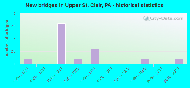
- New bridges - historical statistics
- 11920-1929
- 81940-1949
- 11950-1959
- 31960-1969
- 11990-1999
- 12010-2019
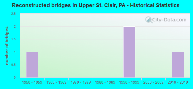
- Reconstructed bridges - Historical Statistics
- 11950-1959
- 01960-1969
- 01970-1979
- 01980-1989
- 21990-1999
- 02000-2009
- 12010-2019
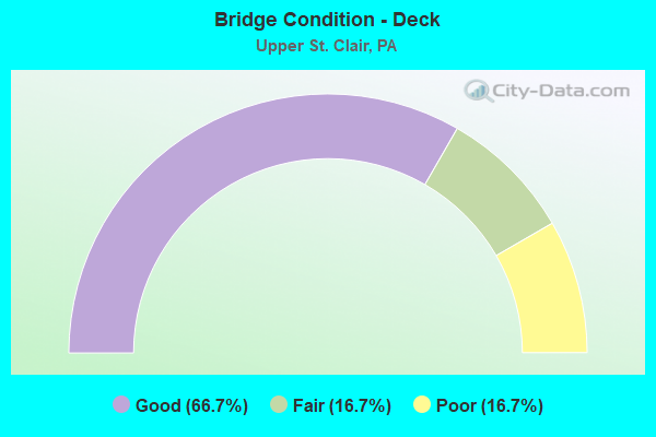
- Bridge Condition - Deck
- 66.7%Good
- 16.7%Fair
- 16.7%Poor
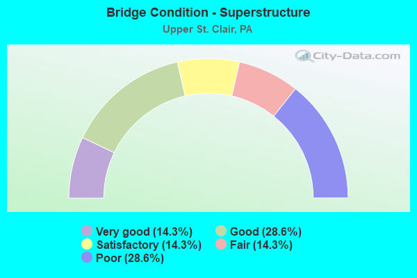
- Bridge Condition - Superstructure
- 14.3%Very good
- 28.6%Good
- 14.3%Satisfactory
- 14.3%Fair
- 28.6%Poor
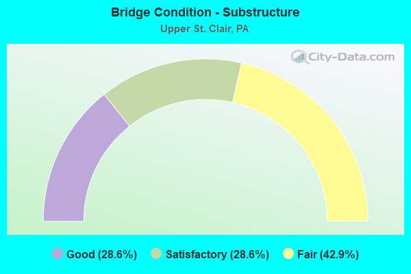
- Bridge Condition - Substructure
- 28.6%Good
- 28.6%Satisfactory
- 42.9%Fair
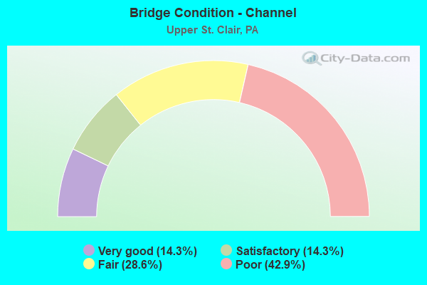
- Bridge Condition - Channel
- 14.3%Very good
- 14.3%Satisfactory
- 28.6%Fair
- 42.9%Poor
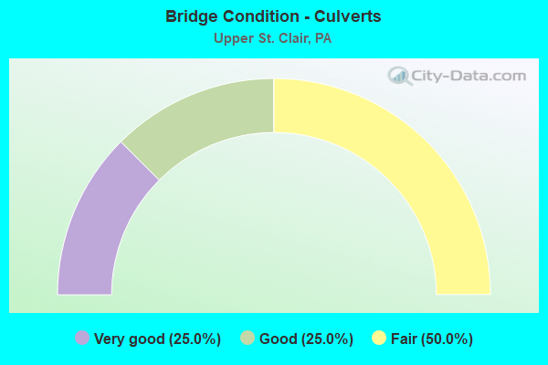
- Bridge Condition - Culverts
- 25.0%Very good
- 25.0%Good
- 50.0%Fair
Find on map >> Show street view
Structure Number: 512, Location: AT CIRCLE DRIVE (Lat: 40.306697, Lng: -80.093883), Route carried "on" structure: US 19, Year Built: 1940, Status: Open, Structure Length: 0.61m (2.00ft), Average Daily Traffic: 24,766 (year 2022), Truck Traffic: 6%, Average Future Daily Traffic: 28,854 (year 2032), Design Load: HS 20, Features Intersected: BR.BRUSH RUN
Minimum Vertical Clearance: 30+ m (98+ ft), Kilometerpoint: 0.000, Lanes on structure: 4, Base Highway Network: Yes, Owner: State Highway Agency, Approaching Roadway Width: 20.4m (66.9ft), Skew: 3 degrees, Material/Design: Concrete, Design/Construction: Culvert, Number Of Spans In Main Unit: 1, Length of Maximum Span: 5.5m (18.0ft)
Condition: Channel: Satisfactory, Culverts: Good, Operating Rating: 49.0 metric tons, Method Used To Determine Operating Rating: Field evaluation and documented engineering judgment, Inventory Rating: 32.7 metric tons, Method Used To Determine Inventory Rating: Field evaluation and documented engineering judgment, Structural Evaluation: Better than present minimum criteria, Waterway Adequacy: Equal to present minimum criteria, Approach Roadway Alignment: Equal to present desirable criteria, Length Of Structure Improvement: 0.50m (1.64ft), Designated Inspection Frequency: Every 24 months, Inspection Date: November 2020, Bridge Improvement Cost: $12,000, Roadway Improvement Cost: $35,000, Total Project Cost: $160,000
Find on map >> Show street view
Structure Number: 513, Location: COUNTRY CLUB RD OVER SR19 (Lat: 40.327278, Lng: -80.075633), Route carried "on" structure: State highway , Year Built: 1940, Year Reconstructed: 2010, Status: Open, Structure Length: 2.19m (7.19ft), Average Daily Traffic: 624 (year 2022), Truck Traffic: 8%, Average Future Daily Traffic: 1,113 (year 2032), Design Load: HS 20, Features Intersected: SR 0019, Facility Carried by Structure: COUNTRY CLUB DR
Minimum Vertical Clearance: 30+ m (98+ ft), Kilometerpoint: 0.000, Lanes on structure: 2, Lanes under structure: 8, Owner: State Highway Agency, Approaching Roadway Width: 7.9m (25.9ft), Skew: 3 degrees, Material/Design: Concrete, Design/Construction: Frame, Number Of Spans In Main Unit: 1, Length of Maximum Span: 17.7m (58.1ft), Curb or Sidewalk Widths: Left: 2.4m (7.9ft), Right: 2.4m (7.9ft), Curb-To-Curb Width: 7.3m (24.0ft), Out-to-Out Width: 11.7m (38.4ft)
Condition: Deck: Good, Superstructure: Good, Substructure: Good, Operating Rating: 49.0 metric tons, Method Used To Determine Operating Rating: Field evaluation and documented engineering judgment, Inventory Rating: 32.7 metric tons, Method Used To Determine Inventory Rating: Field evaluation and documented engineering judgment, Structural Evaluation: Better than present minimum criteria, Deck Geometry: Meets minimum limits, Underclear: Superior to present desirable criteria, Approach Roadway Alignment: Equal to present desirable criteria, Length Of Structure Improvement: 2.20m (7.22ft), Designated Inspection Frequency: Every 24 months, Inspection Date: May 2021, Bridge Improvement Cost: $21,000, Roadway Improvement Cost: $63,000, Total Project Cost: $287,000, Deck Structure Type: Concrete Cast-file-Place, Wearing Surface/Protective System: Wearing Surface: Monolithic Concrete
Find on map >> Show street view
Structure Number: 514, Location: OVER SR 3004 (Lat: 40.331844, Lng: -80.069853), Route carried "on" structure: US 19, Year Built: 1940, Year Reconstructed: 1997, Status: Open, Structure Length: 2.35m (7.71ft), Average Daily Traffic: 27,132 (year 2022), Truck Traffic: 3%, Average Future Daily Traffic: 32,549 (year 2032), Design Load: HS 20, Features Intersected: SR 3004 MCMURRAY RD
Minimum Vertical Clearance: 30+ m (98+ ft), Kilometerpoint: 3.714, Lanes on structure: 4, Lanes under structure: 3, Base Highway Network: Yes, Owner: State Highway Agency, Approaching Roadway Width: 16.5m (54.1ft), Skew: 3 degrees, Material/Design: Steel, Design/Construction: Stringer/Multi-beam, Number Of Spans In Main Unit: 1, Length of Maximum Span: 21.9m (71.9ft), Curb or Sidewalk Widths: Left: 0.2m (0.7ft), Right: 0.2m (0.7ft), Curb-To-Curb Width: 16.5m (54.1ft), Out-to-Out Width: 17.5m (57.4ft)
Condition: Deck: Good, Superstructure: Good, Substructure: Good, Inventory Rating: 90.7 metric tons, Method Used To Determine Inventory Rating: Load Factor (LF), Structural Evaluation: Better than present minimum criteria, Deck Geometry: Meets minimum limits, Underclear: High priority of corrective action, Approach Roadway Alignment: Equal to present desirable criteria, Length Of Structure Improvement: 2.30m (7.55ft), Designated Inspection Frequency: Every 24 months, Inspection Date: November 2020, Deck Structure Type: Concrete Cast-file-Place, Wearing Surface/Protective System: Wearing Surface: Monolithic Concrete, Deck Protection: Epoxy Coated Reinforcing
Find on map >> Show street view
Structure Number: 1696, Location: @ INTER.WITH SR 0019 (Lat: 40.331825, Lng: -80.069833), Route carried "on" structure: State highway , Year Built: 1940, Status: Open, Structure Length: 0.61m (2.00ft), Average Daily Traffic: 13,877 (year 2022), Truck Traffic: 5%, Average Future Daily Traffic: 16,638 (year 2032), Design Load: HS 20, Features Intersected: MCLAUGHLIN RUN, Facility Carried by Structure: MCLAUGHLIN RUN RD
Minimum Vertical Clearance: 30+ m (98+ ft), Kilometerpoint: 5.448, Lanes on structure: 3, Owner: State Highway Agency, Approaching Roadway Width: 17.1m (56.1ft), Skew: 4 degrees, Material/Design: Concrete, Design/Construction: Culvert, Number Of Spans In Main Unit: 1, Length of Maximum Span: 6.1m (20.0ft)
Condition: Channel: Fair, Culverts: Fair, Operating Rating: 49.0 metric tons, Method Used To Determine Operating Rating: Field evaluation and documented engineering judgment, Inventory Rating: 32.7 metric tons, Method Used To Determine Inventory Rating: Field evaluation and documented engineering judgment, Structural Evaluation: Somewhat better than minimum adequacy, Waterway Adequacy: Superior to present desirable criteria, Approach Roadway Alignment: Equal to present desirable criteria, Length Of Structure Improvement: 0.60m (1.97ft), Designated Inspection Frequency: Every 24 months, Inspection Date: May 2021, Bridge Improvement Cost: $18,000, Roadway Improvement Cost: $54,000, Total Project Cost: $246,000
Find on map >> Show street view
Structure Number: 1702, Location: 1/4 MI. EAST OF SR 3005 (Lat: 40.318847, Lng: -80.115836), Route carried "on" structure: State highway , Year Built: 1996, Status: Open, Structure Length: 2.99m (9.81ft), Average Daily Traffic: 9,673 (year 2021), Truck Traffic: 12%, Average Future Daily Traffic: 14,507 (year 2032), Design Load: HS 20, Features Intersected: CHARTIERS CREEK, Facility Carried by Structure: BOYCE RD
Minimum Vertical Clearance: 30+ m (98+ ft), Kilometerpoint: 2.422, Lanes on structure: 2, Owner: State Highway Agency, Approaching Roadway Width: 9.8m (32.2ft), Skew: 9 degrees, Material/Design: Prestressed concrete, Design/Construction: Box Beam or Girders - Multiple, Number Of Spans In Main Unit: 1, Length of Maximum Span: 29.6m (97.1ft), Curb or Sidewalk Widths: Left: 0.2m (0.7ft), Right: 0.2m (0.7ft), Curb-To-Curb Width: 12.6m (41.3ft), Out-to-Out Width: 13.7m (44.9ft)
Condition: Deck: Good, Superstructure: Very good, Substructure: Satisfactory, Channel: Poor, Inventory Rating: 47.2 metric tons, Method Used To Determine Inventory Rating: Load Factor (LF), Structural Evaluation: Equal to present minimum criteria, Deck Geometry: Somewhat better than minimum adequacy, Waterway Adequacy: Better than present minimum criteria, Approach Roadway Alignment: Equal to present desirable criteria, Length Of Structure Improvement: 3.00m (9.84ft), Designated Inspection Frequency: Every 24 months, Inspection Date: May 2021, Deck Structure Type: Concrete Cast-file-Place, Wearing Surface/Protective System: Wearing Surface: Monolithic Concrete, Deck Protection: Epoxy Coated Reinforcing
Find on map >> Show street view
Structure Number: 1752, Location: 300'W.OF INTER.W/SR3003 (Lat: 40.336578, Lng: -80.134347), Route carried "on" structure: State highway , Year Built: 1965, Year Reconstructed: 1998, Status: Open, Structure Length: 6.74m (22.11ft), Average Daily Traffic: 3,175 (year 2022), Truck Traffic: 6%, Average Future Daily Traffic: 3,527 (year 2032), Design Load: HS 20, Features Intersected: SR 0079 NB SB, Facility Carried by Structure: ALPINE RD
Minimum Vertical Clearance: 30+ m (98+ ft), Kilometerpoint: 0.000, Lanes on structure: 2, Lanes under structure: 10, Owner: State Highway Agency, Approaching Roadway Width: 10.7m (35.1ft), Material/Design: Prestressed concrete continuous, Design/Construction: Box Beam or Girders - Single/Spread, Number Of Spans In Main Unit: 2, Number Of Approach Spans: 2, Length of Maximum Span: 21.6m (70.9ft), Curb or Sidewalk Widths: Left: 0.5m (1.6ft), Right: 0.5m (1.6ft), Curb-To-Curb Width: 10.4m (34.1ft), Out-to-Out Width: 11.3m (37.1ft)
Condition: Deck: Good, Superstructure: Satisfactory, Substructure: Satisfactory, Operating Rating: 72.6 metric tons, Method Used To Determine Operating Rating: Load Factor (LF), Inventory Rating: 25.4 metric tons, Method Used To Determine Inventory Rating: Load Factor (LF), Structural Evaluation: Equal to present minimum criteria, Deck Geometry: Somewhat better than minimum adequacy, Underclear: High priority of corrective action, Approach Roadway Alignment: Equal to present desirable criteria, Length Of Structure Improvement: 7.00m (22.97ft), Designated Inspection Frequency: Every 24 months, Inspection Date: May 2021, Deck Structure Type: Concrete Cast-file-Place, Wearing Surface/Protective System: Wearing Surface: Monolithic Concrete
Find on map >> Show street view
Structure Number: 1755, Location: 100'W.OF INTER W/SR3004 (Lat: 40.344914, Lng: -80.082708), Route carried "on" structure: State highway , Year Built: 1941, Status: Open, Structure Length: 0.91m (2.99ft), Average Daily Traffic: 7,112 (year 2022), Truck Traffic: 3%, Average Future Daily Traffic: 7,942 (year 2032), Design Load: HS 20, Features Intersected: MCLAUGHLIN RUN, Facility Carried by Structure: LESNETT RD
Minimum Vertical Clearance: 30+ m (98+ ft), Kilometerpoint: 2.659, Lanes on structure: 2, Owner: State Highway Agency, Approaching Roadway Width: 7.6m (24.9ft), Material/Design: Concrete, Design/Construction: Tee Beam, Number Of Spans In Main Unit: 1, Length of Maximum Span: 7.9m (25.9ft), Curb-To-Curb Width: 7.7m (25.3ft), Out-to-Out Width: 8.4m (27.6ft)
Condition: Deck: Fair, Superstructure: Poor, Substructure: Fair, Channel: Fair, Operating Rating: 49.9 metric tons, Method Used To Determine Operating Rating: Load Factor (LF), Inventory Rating: 29.9 metric tons, Method Used To Determine Inventory Rating: Load Factor (LF), Structural Evaluation: Meets minimum limits, Deck Geometry: High priority of replacement, Waterway Adequacy: Superior to present desirable criteria, Approach Roadway Alignment: Equal to present minimum criteria, Length Of Structure Improvement: 0.80m (2.62ft), Designated Inspection Frequency: Every 24 months, Inspection Date: May 2021, Bridge Improvement Cost: $13,000, Roadway Improvement Cost: $37,000, Total Project Cost: $170,000, Deck Structure Type: Concrete Cast-file-Place, Wearing Surface/Protective System: Wearing Surface: Bituminous
Find on map >> Show street view
Structure Number: 2248, Location: PA03 PAINTERS RUN NO. 3 (Lat: 40.360058, Lng: -80.072664), Route carried "on" structure: County highway , Year Built: 1955, Status: Open, Structure Length: 1.04m (3.41ft), Average Daily Traffic: 15,049 (year 2005), Truck Traffic: 5%, Average Future Daily Traffic: 19,108 (year 2023), Design Load: HS 20, Features Intersected: PAINTERS RUN, Facility Carried by Structure: PAINTERS RUN RD
Minimum Vertical Clearance: 30+ m (98+ ft), Kilometerpoint: 0.000, Lanes on structure: 2, Base Highway Network: Yes, Owner: County Highway Agency, Approaching Roadway Width: 11.0m (36.1ft), Skew: 5 degrees, Material/Design: Prestressed concrete, Design/Construction: Box Beam or Girders - Multiple, Number Of Spans In Main Unit: 1, Length of Maximum Span: 9.1m (29.9ft), Curb or Sidewalk Widths: Left: 1.2m (3.9ft), Right: 1.4m (4.6ft), Curb-To-Curb Width: 11.1m (36.4ft), Out-to-Out Width: 13.9m (45.6ft)
Condition: Deck: Poor, Superstructure: Poor, Substructure: Fair, Channel: Poor, Operating Rating: 80.7 metric tons, Method Used To Determine Operating Rating: Load Factor (LF), Inventory Rating: 39.9 metric tons, Method Used To Determine Inventory Rating: Load Factor (LF), Structural Evaluation: Meets minimum limits, Deck Geometry: Meets minimum limits, Waterway Adequacy: Equal to present desirable criteria, Approach Roadway Alignment: Equal to present desirable criteria, Length Of Structure Improvement: 1.00m (3.28ft), Designated Inspection Frequency: Every 24 months, Inspection Date: April 2021, Deck Structure Type: Other, Wearing Surface/Protective System: Wearing Surface: Bituminous
Find on map >> Show street view
Structure Number: 2251, Location: PA08 PAINTERS RUN NO. 8 (Lat: 40.362794, Lng: -80.087247), Route carried "on" structure: County highway , Year Built: 1927, Year Reconstructed: 1950, Status: Open, Structure Length: 1.65m (5.41ft), Average Daily Traffic: 15,909 (year 2005), Truck Traffic: 5%, Average Future Daily Traffic: 20,200 (year 2030), Features Intersected: PAINTERS RUN, Facility Carried by Structure: BOWER HILL RD
Minimum Vertical Clearance: 30+ m (98+ ft), Kilometerpoint: 0.000, Lanes on structure: 2, Owner: County Highway Agency, Approaching Roadway Width: 11.6m (38.1ft), Skew: 3 degrees, Material/Design: Concrete, Design/Construction: Culvert, Number Of Spans In Main Unit: 2, Length of Maximum Span: 7.6m (24.9ft), Curb-To-Curb Width: 11.6m (38.1ft), Out-to-Out Width: 11.6m (38.1ft)
Condition: Superstructure: Fair, Substructure: Fair, Channel: Poor, Culverts: Fair, Operating Rating: 54.4 metric tons, Method Used To Determine Operating Rating: Load Factor (LF), Inventory Rating: 32.7 metric tons, Method Used To Determine Inventory Rating: Load Factor (LF), Structural Evaluation: Somewhat better than minimum adequacy, Deck Geometry: Somewhat better than minimum adequacy, Waterway Adequacy: Equal to present desirable criteria, Approach Roadway Alignment: Equal to present desirable criteria, Length Of Structure Improvement: 1.60m (5.25ft), Designated Inspection Frequency: Every 24 months, Inspection Date: April 2021, Bridge Improvement Cost: $14,000, Roadway Improvement Cost: $48,000, Total Project Cost: $190,000
Find on map >> Show street view
Structure Number: 53805, Location: 200'W.OF INTER.W/SR 3004 (Lat: 40.340192, Lng: -80.079081), Route carried "on" structure: State highway , Year Built: 2017, Status: Open, Structure Length: 0.70m (2.30ft), Average Daily Traffic: 2,716 (year 2021), Truck Traffic: 3%, Average Future Daily Traffic: 2,976 (year 2037), Design Load: HL 93, Features Intersected: MCLAUGHLIN RUN, Facility Carried by Structure: MORROW RD (SR3008)
Minimum Vertical Clearance: 30+ m (98+ ft), Kilometerpoint: 0.000, Lanes on structure: 2, Owner: State Highway Agency, Maintenance Responsibility: Private, Approaching Roadway Width: 7.0m (23.0ft), Skew: 1 degrees, Material/Design: Concrete, Design/Construction: Culvert, Number Of Spans In Main Unit: 1, Length of Maximum Span: 6.4m (21.0ft), Curb-To-Curb Width: 8.8m (28.9ft), Out-to-Out Width: 10.2m (33.5ft)
Condition: Channel: Very good, Culverts: Very good, Operating Rating: 52.8 metric tons, Method Used To Determine Operating Rating: Assigned ratings based on Load and Resistance Factor Design (LRFD) reported by rating factor (RF) using HL93 loadings, Inventory Rating: 33.4 metric tons, Method Used To Determine Inventory Rating: Assigned ratings based on Load and Resistance Factor Design (LRFD) reported by rating factor (RF) using HL93 loadings, Structural Evaluation: Equal to present desirable criteria, Deck Geometry: Meets minimum limits, Waterway Adequacy: Better than present minimum criteria, Approach Roadway Alignment: Equal to present desirable criteria, Designated Inspection Frequency: Every 24 months, Inspection Date: March 2021, Wearing Surface/Protective System: Wearing Surface: Bituminous, Membrane: Preformed Fabric, Deck Protection: Epoxy Coated Reinforcing
Find on map >> Show street view
Structure Number: 513, Location: COUNTRY CLUB RD OVER SR19 (Lat: 40.327278, Lng: -80.075633), Route carried "under" structure: US 19, Year Built: 1940, Structure Length: 0. m, Average Daily Traffic: 14,862 (year 2022), Truck Traffic: 3%, Features Intersected: SR 0019, Facility Carried by Structure: COUNTRY CLUB DR
Minimum Vertical Clearance: 7.14m (23.43ft), Kilometerpoint: 2.992, Lanes on structure: 2, Lanes under structure: 4, Material/Design: Concrete, Design/Construction: Frame, Length of Maximum Span: 17.7m (58.1ft)
Find on map >> Show street view
Structure Number: 513, Location: COUNTRY CLUB RD OVER SR19 (Lat: 40.327278, Lng: -80.075633), Route carried "under" structure: US 19, Year Built: 1940, Structure Length: 0. m, Average Daily Traffic: 12,671 (year 2022), Truck Traffic: 3%, Features Intersected: SR 0019, Facility Carried by Structure: COUNTRY CLUB DR
Minimum Vertical Clearance: 7.14m (23.43ft), Kilometerpoint: 2.990, Lanes on structure: 2, Lanes under structure: 4, Material/Design: Concrete, Design/Construction: Frame, Length of Maximum Span: 17.7m (58.1ft)
Find on map >> Show street view
Structure Number: 514, Location: OVER SR 3004 (Lat: 40.331844, Lng: -80.069853), Route carried "under" structure: State highway , Year Built: 1940, Structure Length: 0. m, Average Daily Traffic: 13,877 (year 2022), Truck Traffic: 5%, Features Intersected: SR 3004 MCMURRAY RD, Facility Carried by Structure: SR 0019 NB SB
Minimum Vertical Clearance: 4.42m (14.50ft), Kilometerpoint: 5.448, Lanes on structure: 4, Lanes under structure: 3, Material/Design: Steel, Design/Construction: Stringer/Multi-beam, Length of Maximum Span: 21.9m (71.9ft)
Find on map >> Show street view
Structure Number: 1752, Location: 300'W.OF INTER.W/SR3003 (Lat: 40.336578, Lng: -80.134347), Route carried "under" structure: Interstate 79, Year Built: 1965, Structure Length: 0. m, Average Daily Traffic: 36,907 (year 2022), Truck Traffic: 13%, Features Intersected: SR 0079 NB SB, Facility Carried by Structure: ALPINE RD
Minimum Vertical Clearance: 5.92m (19.42ft), Kilometerpoint: 1.436, Lanes on structure: 2, Lanes under structure: 5, Material/Design: Prestressed concrete continuous, Design/Construction: Box Beam or Girders - Single/Spread, Length of Maximum Span: 21.6m (70.9ft)
Find on map >> Show street view
Structure Number: 1752, Location: 300'W.OF INTER.W/SR3003 (Lat: 40.336578, Lng: -80.134347), Route carried "under" structure: Interstate 79, Year Built: 1965, Structure Length: 0. m, Average Daily Traffic: 36,039 (year 2022), Truck Traffic: 14%, Features Intersected: SR 0079 NB SB, Facility Carried by Structure: ALPINE RD
Minimum Vertical Clearance: 5.92m (19.42ft), Kilometerpoint: 1.418, Lanes on structure: 2, Lanes under structure: 5, Material/Design: Prestressed concrete continuous, Design/Construction: Box Beam or Girders - Single/Spread, Length of Maximum Span: 21.6m (70.9ft)