Bridge Statistics for Utica, Indiana (IN)
Condition, Traffic, Stress, Structural Evaluation, Project Costs
- National Bridge Inventory (NBI) Statistics
- 12Number of bridges
- 669ft / 204mTotal length
- $687,000Total costs
- 85,000Total average daily traffic
- 10,473Total average daily truck traffic
- National Bridge Inventory (NBI) Registered Bridges for Utica
- No street view available for this location
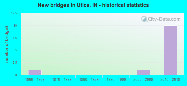
- New bridges - historical statistics
- 11960-1969
- 12000-2009
- 102010-2019


- Bridge Condition - Deck
- 75.0%Very good
- 12.5%Good
- 12.5%Fair

- Bridge Condition - Superstructure
- 50.0%Very good
- 25.0%Good
- 25.0%Satisfactory

- Bridge Condition - Substructure
- 75.0%Very good
- 12.5%Good
- 12.5%Fair

- Bridge Condition - Channel
- 50.0%Excellent
- 12.5%Very good
- 12.5%Good
- 12.5%Satisfactory
- 12.5%Fair
Find on map >> Show street view
Structure Number: 80655, Location: 2.40 E SR-62 (Lat: 38.349769, Lng: -85.659819), Route carried "on" structure: State highway 265, Year Built: 2016, Status: Open, Structure Length: 12.65m (41.50ft), Average Daily Traffic: 12,700 (year 2010), Truck Traffic: 12%, Average Future Daily Traffic: 26,000 (year 2030), Design Load: HL 93, Features Intersected: LENTZIER CREEK TRIBUTARY
Minimum Vertical Clearance: 30+ m (98+ ft), Kilometerpoint: 18.958, Lanes on structure: 2, Base Highway Network: Yes (, Subroute: 1), Owner: State Highway Agency, Maintenance Responsibility: State Toll Authority, Approaching Roadway Width: 22.3m (73.2ft), Material/Design: Prestressed concrete continuous, Design/Construction: Stringer/Multi-beam, Number Of Spans In Main Unit: 3, Length of Maximum Span: 44.2m (145.0ft), Curb or Sidewalk Widths: Left: 0.0m, Right: 4.0m (13.1ft), Curb-To-Curb Width: 16.9m (55.4ft), Out-to-Out Width: 22.1m (72.5ft)
Condition: Deck: Very good, Superstructure: Good, Substructure: Very good, Channel: Excellent, Operating Rating: 48.0 metric tons, Method Used To Determine Operating Rating: Load and Resistance Factor Rating (LRFR) rating reported by rating factor(RF) method using HL-93 loadings, Inventory Rating: 35.6 metric tons, Method Used To Determine Inventory Rating: Load and Resistance Factor Rating (LRFR) rating reported by rating factor(RF) method using HL-93 loadings, Structural Evaluation: Better than present minimum criteria, Deck Geometry: Superior to present desirable criteria, Waterway Adequacy: Superior to present desirable criteria, Approach Roadway Alignment: Equal to present desirable criteria, Designated Inspection Frequency: Every 24 months, Inspection Date: July 2020, Deck Structure Type: Concrete Cast-file-Place, Wearing Surface/Protective System: Wearing Surface: Monolithic Concrete, Deck Protection: Epoxy Coated Reinforcing
Find on map >> Show street view
Structure Number: 80656, Location: 2.40 E SR-62 (Lat: 38.350281, Lng: -85.659739), Route carried "on" structure: State highway 265, Year Built: 2016, Status: Open, Structure Length: 12.63m (41.44ft), Average Daily Traffic: 12,700 (year 2010), Truck Traffic: 12%, Average Future Daily Traffic: 26,000 (year 2030), Design Load: HL 93, Features Intersected: LENTZIER CREEK TRIBUTARY
Minimum Vertical Clearance: 30+ m (98+ ft), Kilometerpoint: 19.280, Lanes on structure: 2, Base Highway Network: Yes (, Subroute: 1), Owner: State Highway Agency, Maintenance Responsibility: State Toll Authority, Approaching Roadway Width: 17.8m (58.4ft), Material/Design: Prestressed concrete continuous, Design/Construction: Stringer/Multi-beam, Number Of Spans In Main Unit: 3, Length of Maximum Span: 44.0m (144.4ft), Curb-To-Curb Width: 16.9m (55.4ft), Out-to-Out Width: 17.8m (58.4ft)
Condition: Deck: Very good, Superstructure: Very good, Substructure: Very good, Channel: Excellent, Operating Rating: 48.9 metric tons, Method Used To Determine Operating Rating: Load and Resistance Factor Rating (LRFR) rating reported by rating factor(RF) method using HL-93 loadings, Inventory Rating: 37.3 metric tons, Method Used To Determine Inventory Rating: Load and Resistance Factor Rating (LRFR) rating reported by rating factor(RF) method using HL-93 loadings, Structural Evaluation: Equal to present desirable criteria, Deck Geometry: Superior to present desirable criteria, Waterway Adequacy: Superior to present desirable criteria, Approach Roadway Alignment: Equal to present desirable criteria, Designated Inspection Frequency: Every 24 months, Inspection Date: July 2020, Deck Structure Type: Concrete Cast-file-Place, Wearing Surface/Protective System: Wearing Surface: Monolithic Concrete, Deck Protection: Epoxy Coated Reinforcing
Find on map >> Show street view
Structure Number: 80659, Location: 1.30 E SR 62 (Lat: 38.344781, Lng: -85.682739), Route carried "on" structure: State highway 265, Year Built: 2016, Status: Open, Structure Length: 15.32m (50.26ft), Average Daily Traffic: 19,500 (year 2010), Truck Traffic: 15%, Average Future Daily Traffic: 19,500 (year 2030), Design Load: HL 93, Features Intersected: ROAD & LENTZIER CR TRIB
Minimum Vertical Clearance: 30+ m (98+ ft), Kilometerpoint: 17.510, Lanes on structure: 2, Lanes under structure: 2, Base Highway Network: Yes (, Subroute: 1), Owner: State Highway Agency, Maintenance Responsibility: State Toll Authority, Approaching Roadway Width: 14.1m (46.3ft), Skew: 2 degrees, Material/Design: Prestressed concrete continuous, Design/Construction: Stringer/Multi-beam, Number Of Spans In Main Unit: 4, Number Of Approach Spans: 2, Length of Maximum Span: 43.9m (144.0ft), Curb-To-Curb Width: 13.2m (43.3ft), Out-to-Out Width: 14.1m (46.3ft)
Condition: Deck: Very good, Superstructure: Very good, Substructure: Very good, Channel: Excellent, Operating Rating: 43.7 metric tons, Method Used To Determine Operating Rating: Load and Resistance Factor Rating (LRFR) rating reported by rating factor(RF) method using HL-93 loadings, Inventory Rating: 33.7 metric tons, Method Used To Determine Inventory Rating: Load and Resistance Factor Rating (LRFR) rating reported by rating factor(RF) method using HL-93 loadings, Structural Evaluation: Equal to present desirable criteria, Deck Geometry: Superior to present desirable criteria, Underclear: Meets minimum limits, Waterway Adequacy: Superior to present desirable criteria, Approach Roadway Alignment: Equal to present desirable criteria, Designated Inspection Frequency: Every 24 months, Inspection Date: July 2020, Deck Structure Type: Concrete Cast-file-Place, Wearing Surface/Protective System: Wearing Surface: Monolithic Concrete, Deck Protection: Epoxy Coated Reinforcing
Find on map >> Show street view
Structure Number: 8066, Location: 1.30 E SR 62 (Lat: 38.344431, Lng: -85.682431), Route carried "on" structure: State highway 265, Year Built: 2016, Status: Open, Structure Length: 15.29m (50.16ft), Average Daily Traffic: 19,500 (year 2010), Truck Traffic: 15%, Average Future Daily Traffic: 19,500 (year 2030), Design Load: HL 93, Features Intersected: ROAD & LENTZIER CR TRIB
Minimum Vertical Clearance: 30+ m (98+ ft), Kilometerpoint: 17.510, Lanes on structure: 2, Lanes under structure: 2, Base Highway Network: Yes (, Subroute: 1), Owner: State Highway Agency, Maintenance Responsibility: State Toll Authority, Approaching Roadway Width: 14.1m (46.3ft), Skew: 2 degrees, Material/Design: Prestressed concrete continuous, Design/Construction: Stringer/Multi-beam, Number Of Spans In Main Unit: 4, Length of Maximum Span: 43.9m (144.0ft), Curb-To-Curb Width: 13.2m (43.3ft), Out-to-Out Width: 14.1m (46.3ft)
Condition: Deck: Very good, Superstructure: Very good, Substructure: Very good, Channel: Excellent, Operating Rating: 43.4 metric tons, Method Used To Determine Operating Rating: Load and Resistance Factor Rating (LRFR) rating reported by rating factor(RF) method using HL-93 loadings, Inventory Rating: 33.4 metric tons, Method Used To Determine Inventory Rating: Load and Resistance Factor Rating (LRFR) rating reported by rating factor(RF) method using HL-93 loadings, Structural Evaluation: Equal to present desirable criteria, Deck Geometry: Superior to present desirable criteria, Underclear: Meets minimum limits, Waterway Adequacy: Superior to present desirable criteria, Approach Roadway Alignment: Equal to present desirable criteria, Designated Inspection Frequency: Every 24 months, Inspection Date: July 2020, Deck Structure Type: Concrete Cast-file-Place, Wearing Surface/Protective System: Wearing Surface: Monolithic Concrete, Deck Protection: Epoxy Coated Reinforcing
Find on map >> Show street view
Structure Number: 80663, Location: 3.57 E SR 62 (Lat: 38.342631, Lng: -85.643231), Route carried "on" structure: State highway 265, Year Built: 2016, Status: Open, Structure Length: 135.01m (442.95ft), Average Daily Traffic: 12,700 (year 2016), Truck Traffic: 9%, Average Future Daily Traffic: 26,000 (year 2030), Design Load: HL 93, Features Intersected: OHIO RIVER, 2 LOCAL ROAD
Minimum Vertical Clearance: 6.10m (20.01ft), Kilometerpoint: 20.954, Lanes on structure: 4, Lanes under structure: 4, Base Highway Network: Yes (, Subroute: 1), Toll: On toll road, Owner: State Highway Agency, Maintenance Responsibility: State Toll Authority, Approaching Roadway Width: 30.2m (99.1ft), Skew: 30 degrees, Navigation Control: Yes ( Vertical Clearance: 21.6m (70.9ft), Horizontal Clearance: 274.3m (899.9ft)), Material/Design: Steel continuous, Design/Construction: Stayed Girder, Number Of Spans In Main Unit: 3, Number Of Approach Spans: 10, Length of Maximum Span: 459.0m (1,505.9ft), Curb or Sidewalk Widths: Left: 3.4m (11.2ft), Right: 0.0m, Curb-To-Curb Width: 29.3m (96.1ft), Out-to-Out Width: 34.9m (114.5ft)
Condition: Deck: Very good, Superstructure: Very good, Substructure: Very good, Channel: Satisfactory, Operating Rating: 46.7 metric tons, Method Used To Determine Operating Rating: Load and Resistance Factor (LRFR), Inventory Rating: 46.7 metric tons, Method Used To Determine Inventory Rating: Load and Resistance Factor (LRFR), Structural Evaluation: Equal to present desirable criteria, Deck Geometry: Superior to present desirable criteria, Underclear: Equal to present minimum criteria, Waterway Adequacy: Superior to present desirable criteria, Approach Roadway Alignment: Equal to present desirable criteria, Designated Inspection Frequency: Every 24 months, Critical Feature Inspection Frequency: Every 24 months, Underwater Inspection Frequency: Every 48 months, Other Special Inspection Frequency: Every 12 months, Inspection Date: July 2020, Critical Feature Inspection Date: July 2020, Underwater Inspection Date: September 2020, Other Special Inspection Date: June 2021, Deck Structure Type: Concrete Precast Panels, Wearing Surface/Protective System: Wearing Surface: Latex Concrete, Deck Protection: Epoxy Coated Reinforcing
Find on map >> Show street view
Structure Number: 1000006, Location: 00.10 E of Fox Run Trail (Lat: 38.333019, Lng: -85.664697), Route carried "on" structure: City street , Year Built: 1965, Year Reconstructed: 1989, Status: Open, Structure Length: 1.01m (3.31ft), Average Daily Traffic: 820 (year 2018), Truck Traffic: 5%, Average Future Daily Traffic: 1,430 (year 2038), Features Intersected: LENTZIER CREEK, Facility Carried by Structure: UTICA-SELLERSBG.RD
Minimum Vertical Clearance: 30+ m (98+ ft), Kilometerpoint: 0.000, Lanes on structure: 2, Owner: County Highway Agency, Approaching Roadway Width: 5.5m (18.0ft), Skew: 4 degrees, Material/Design: Steel, Design/Construction: Stringer/Multi-beam, Number Of Spans In Main Unit: 1, Length of Maximum Span: 8.3m (27.2ft), Curb-To-Curb Width: 7.2m (23.6ft), Out-to-Out Width: 7.3m (24.0ft)
Condition: Deck: Fair, Superstructure: Satisfactory, Substructure: Fair, Channel: Fair, Operating Rating: 32.7 metric tons, Method Used To Determine Operating Rating: Field evaluation and documented engineering judgment, Inventory Rating: 32.7 metric tons, Method Used To Determine Inventory Rating: Field evaluation and documented engineering judgment, Structural Evaluation: Somewhat better than minimum adequacy, Deck Geometry: Meets minimum limits, Waterway Adequacy: Equal to present minimum criteria, Approach Roadway Alignment: Equal to present minimum criteria, Length Of Structure Improvement: 1.52m (4.99ft), Designated Inspection Frequency: Every 24 months, Inspection Date: March 2020, Bridge Improvement Cost: $318,000, Roadway Improvement Cost: $227,000, Total Project Cost: $687,000 ( Estimate for 2020), Deck Structure Type: Concrete Cast-file-Place, Wearing Surface/Protective System: Wearing Surface: Monolithic Concrete, Deck Protection: Epoxy Coated Reinforcing
Find on map >> Show street view
Structure Number: 1000127, Location: 00.20 S of UtcaSellrsburg (Lat: 38.330650, Lng: -85.656067), Route carried "on" structure: City street , Year Built: 2000, Status: Open, Structure Length: 1.04m (3.41ft), Average Daily Traffic: 3,820 (year 2018), Truck Traffic: 6%, Average Future Daily Traffic: 6,650 (year 2038), Features Intersected: LENTIGIER CREEK, Facility Carried by Structure: UTICA PIKE
Minimum Vertical Clearance: 30+ m (98+ ft), Kilometerpoint: 0.000, Lanes on structure: 2, Owner: County Highway Agency, Approaching Roadway Width: 6.1m (20.0ft), Material/Design: Steel, Design/Construction: Stringer/Multi-beam, Number Of Spans In Main Unit: 1, Length of Maximum Span: 9.2m (30.2ft), Curb or Sidewalk Widths: Left: 1.5m (4.9ft), Right: 1.5m (4.9ft), Curb-To-Curb Width: 7.8m (25.6ft), Out-to-Out Width: 12.3m (40.4ft)
Condition: Deck: Good, Superstructure: Satisfactory, Substructure: Good, Channel: Good, Structural Evaluation: Equal to present minimum criteria, Deck Geometry: High priority of replacement, Waterway Adequacy: Better than present minimum criteria, Approach Roadway Alignment: Equal to present desirable criteria, Designated Inspection Frequency: Every 24 months, Inspection Date: March 2020, Deck Structure Type: Concrete Cast-file-Place, Wearing Surface/Protective System: Wearing Surface: Monolithic Concrete
Find on map >> Show street view
Structure Number: 1000147, Location: 0.40 E of Uttica Rd (Lat: 38.344450, Lng: -85.682539), Route carried "on" structure: City street , Year Built: 2015, Status: Open, Structure Length: 10.76m (35.30ft), Average Daily Traffic: 820 (year 2018), Truck Traffic: 5%, Average Future Daily Traffic: 1,430 (year 2038), Design Load: HL 93, Features Intersected: LENTZIER CREEK, Facility Carried by Structure: BROOKHOLLOW WAY
Minimum Vertical Clearance: 4.60m (15.09ft), Kilometerpoint: 0.000, Lanes on structure: 2, Owner: County Highway Agency, Approaching Roadway Width: 10.7m (35.1ft), Material/Design: Prestressed concrete continuous, Design/Construction: Stringer/Multi-beam, Number Of Spans In Main Unit: 4, Length of Maximum Span: 30.2m (99.1ft), Curb-To-Curb Width: 11.0m (36.1ft), Out-to-Out Width: 11.7m (38.4ft)
Condition: Deck: Very good, Superstructure: Good, Substructure: Very good, Channel: Very good, Operating Rating: 76.1 metric tons, Method Used To Determine Operating Rating: Load and Resistance Factor (LRFR), Inventory Rating: 55.4 metric tons, Method Used To Determine Inventory Rating: Load and Resistance Factor (LRFR), Structural Evaluation: Better than present minimum criteria, Deck Geometry: Equal to present minimum criteria, Waterway Adequacy: Equal to present desirable criteria, Approach Roadway Alignment: Equal to present minimum criteria, Designated Inspection Frequency: Every 24 months, Inspection Date: March 2020, Deck Structure Type: Concrete Cast-file-Place, Wearing Surface/Protective System: Wearing Surface: Monolithic Concrete, Deck Protection: Epoxy Coated Reinforcing
Find on map >> Show street view
Structure Number: 80659, Location: 1.30 E SR 62 (Lat: 38.344450, Lng: -85.682550), Route carried "under" structure: City street , Year Built: 2016, Structure Length: 0. m, Average Daily Traffic: 670 (year 2012), Truck Traffic: 5%, Features Intersected: BROOKHOLLOW WAY, Facility Carried by Structure: SR 265 WB
Minimum Vertical Clearance: 4.60m (15.09ft), Kilometerpoint: 0.000, Lanes on structure: 2, Lanes under structure: 2, Material/Design: Prestressed concrete continuous, Design/Construction: Tee Beam, Length of Maximum Span: 43.9m (144.0ft)
Find on map >> Show street view
Structure Number: 8066, Location: 1.30 E SR 62 (Lat: 38.344450, Lng: -85.682550), Route carried "under" structure: City street , Year Built: 2016, Structure Length: 0. m, Average Daily Traffic: 670 (year 2012), Truck Traffic: 5%, Features Intersected: BROOKHOLLOW WAY, Facility Carried by Structure: SR 265 EB
Minimum Vertical Clearance: 4.60m (15.09ft), Kilometerpoint: 0.000, Lanes on structure: 2, Lanes under structure: 2, Material/Design: Prestressed concrete continuous, Design/Construction: Tee Beam, Length of Maximum Span: 43.9m (144.0ft)
Find on map >> Show street view
Structure Number: 80663, Location: 4.04 S SR-62 (Lat: 38.342631, Lng: -85.643231), Route carried "under" structure: City street , Year Built: 2016, Structure Length: 0. m, Average Daily Traffic: 500 (year 2016), Truck Traffic: 5%, Features Intersected: TRANSLYVANIA BEACH ROAD, Facility Carried by Structure: SR 265
Minimum Vertical Clearance: 17.37m (56.99ft), Kilometerpoint: 21.710, Lanes on structure: 4, Lanes under structure: 4, Material/Design: Steel continuous, Design/Construction: Stayed Girder, Length of Maximum Span: 365.8m (1,200.1ft)
Find on map >> Show street view
Structure Number: 80663, Location: 4.40 S SR-62 (Lat: 38.342631, Lng: -85.643231), Route carried "under" structure: County highway , Year Built: 2016, Structure Length: 0. m, Average Daily Traffic: 600 (year 2016), Truck Traffic: 5%, Features Intersected: UPPER RIVER ROAD, Facility Carried by Structure: SR 265
Minimum Vertical Clearance: 21.03m (69.00ft), Kilometerpoint: 21.710, Lanes on structure: 4, Lanes under structure: 4, Material/Design: Steel continuous, Design/Construction: Stayed Girder, Length of Maximum Span: 365.8m (1,200.1ft)