Bridge Statistics for Valley Head, West Virginia (WV)
Condition, Traffic, Stress, Structural Evaluation, Project Costs
- National Bridge Inventory (NBI) Statistics
- 16Number of bridges
- 118ft / 35.9mTotal length
- $7,850,000Total costs
- 8,518Total average daily traffic
- 887Total average daily truck traffic
- 10,812Total future (year 2036) average daily traffic
- National Bridge Inventory (NBI) Registered Bridges for Valley Head
- No street view available for this location
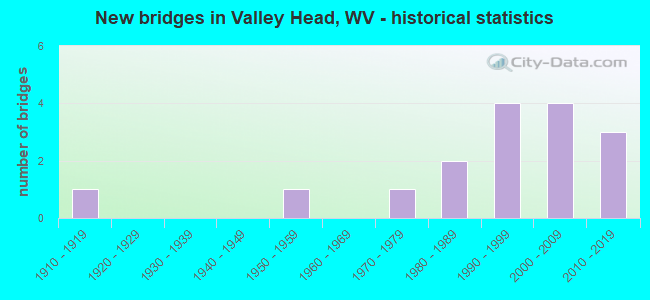
- New bridges - historical statistics
- 11910-1919
- 11950-1959
- 11970-1979
- 21980-1989
- 41990-1999
- 42000-2009
- 32010-2019

- Bridge Condition - Deck
- 7.7%Very good
- 46.2%Good
- 23.1%Satisfactory
- 23.1%Poor

- Bridge Condition - Superstructure
- 14.3%Very good
- 35.7%Good
- 21.4%Satisfactory
- 14.3%Poor
- 14.3%Serious

- Bridge Condition - Substructure
- 14.3%Very good
- 64.3%Good
- 7.1%Satisfactory
- 14.3%Poor

- Bridge Condition - Channel
- 18.8%Very good
- 37.5%Good
- 25.0%Satisfactory
- 18.8%Fair

- Bridge Condition - Culverts
- 50.0%Good
- 50.0%Satisfactory
Find on map >> Show street view
Structure Number: 42A03, Location: 0.23 MI W JCT US 319 (Lat: 38.552600, Lng: -80.037261), Route carried "on" structure: State highway 1500, Year Built: 1955, Status: Open, Structure Length: 3.93m (12.89ft), Average Daily Traffic: 1,000 (year 2019), Truck Traffic: 11%, Average Future Daily Traffic: 1,278 (year 2039), Design Load: HS 15, Features Intersected: TYGART VALLEY RIVER, Facility Carried by Structure: WV 15
Minimum Vertical Clearance: 30+ m (98+ ft), Kilometerpoint: 18.250, Lanes on structure: 2, Owner: State Highway Agency, Approaching Roadway Width: 11.6m (38.1ft), Skew: 1 degrees, Material/Design: Concrete, Design/Construction: Tee Beam, Number Of Spans In Main Unit: 3, Length of Maximum Span: 12.7m (41.7ft), Curb or Sidewalk Widths: Left: 0.3m (1.0ft), Right: 0.3m (1.0ft), Curb-To-Curb Width: 7.9m (25.9ft), Out-to-Out Width: 9.1m (29.9ft)
Condition: Deck: Poor, Superstructure: Serious, Substructure: Poor, Channel: Satisfactory, Operating Rating: 52.6 metric tons, Method Used To Determine Operating Rating: Load Factor (LF), Inventory Rating: 31.7 metric tons, Method Used To Determine Inventory Rating: Load Factor (LF), Structural Evaluation: High priority of corrective action, Deck Geometry: Somewhat better than minimum adequacy, Waterway Adequacy: Equal to present desirable criteria, Approach Roadway Alignment: Equal to present desirable criteria, Length Of Structure Improvement: 4.88m (16.01ft), Designated Inspection Frequency: Every 24 months, Other Special Inspection Frequency: Every 12 months, Inspection Date: April 2020, Other Special Inspection Date: April 2021, Bridge Improvement Cost: $3,100,000, Roadway Improvement Cost: $700,000, Total Project Cost: $4,500,000 ( Estimate for 2021), Deck Structure Type: Concrete Cast-file-Place, Wearing Surface/Protective System: Wearing Surface: Latex Concrete
Find on map >> Show street view
Structure Number: 42A031, Location: 0.07 MI. W. U.S.219 (Lat: 38.545589, Lng: -80.037019), Route carried "on" structure: County highway 1505, Year Built: 1915, Status: Posted for load, Structure Length: 3.98m (13.06ft), Average Daily Traffic: 50 (year 2021), Average Future Daily Traffic: 64 (year 2041), Features Intersected: TYGART VALLEY RIVER, Facility Carried by Structure: C.R. 15/5
Minimum Vertical Clearance: 30+ m (98+ ft), Kilometerpoint: 0.113, Lanes on structure: 1, Owner: State Highway Agency, Approaching Roadway Width: 4.6m (15.1ft), Material/Design: Concrete, Design/Construction: Arch - Deck, Number Of Spans In Main Unit: 2, Length of Maximum Span: 14.8m (48.6ft), Curb-To-Curb Width: 4.6m (15.1ft), Out-to-Out Width: 5.1m (16.7ft)
Condition: Superstructure: Serious, Substructure: Poor, Channel: Fair, Operating Rating: 10.9 metric tons, Method Used To Determine Operating Rating: Field evaluation and documented engineering judgment, Inventory Rating: 8.2 metric tons, Method Used To Determine Inventory Rating: Field evaluation and documented engineering judgment, Structural Evaluation: High priority of replacement, Deck Geometry: Better than present minimum criteria, Waterway Adequacy: Equal to present minimum criteria, Approach Roadway Alignment: Meets minimum limits, Bridge Posting: Required (Relationship of Operating Rating to Maximum Legal Load: > 39.9% below), Length Of Structure Improvement: 3.66m (12.01ft), Designated Inspection Frequency: Every 24 months, Other Special Inspection Frequency: Every 12 months, Inspection Date: November 2020, Other Special Inspection Date: November 2021, Bridge Improvement Cost: $1,550,000, Roadway Improvement Cost: $400,000, Total Project Cost: $2,500,000 ( Estimate for 2022)
Find on map >> Show street view
Structure Number: 42A032, Location: 0.05 MI S JCT W. V. 15 (Lat: 38.550700, Lng: -80.040250), Route carried "on" structure: County highway 1505, Year Built: 1991, Status: Open, Structure Length: 2.25m (7.38ft), Average Daily Traffic: 50 (year 2018), Average Future Daily Traffic: 64 (year 2038), Design Load: HS 25 or greater, Features Intersected: RALSTON RUN, Facility Carried by Structure: C. R. 15/5
Minimum Vertical Clearance: 30+ m (98+ ft), Kilometerpoint: 0.821, Lanes on structure: 2, Owner: State Highway Agency, Approaching Roadway Width: 7.0m (23.0ft), Material/Design: Prestressed concrete, Design/Construction: Box Beam or Girders - Multiple, Number Of Spans In Main Unit: 1, Length of Maximum Span: 21.3m (69.9ft), Curb-To-Curb Width: 5.2m (17.1ft), Out-to-Out Width: 5.5m (18.0ft)
Condition: Deck: Satisfactory, Superstructure: Satisfactory, Substructure: Good, Channel: Good, Operating Rating: 88.9 metric tons, Method Used To Determine Operating Rating: Load Factor (LF), Inventory Rating: 66.2 metric tons, Method Used To Determine Inventory Rating: Load Factor (LF), Structural Evaluation: Equal to present minimum criteria, Deck Geometry: High priority of corrective action, Waterway Adequacy: Better than present minimum criteria, Approach Roadway Alignment: Better than present minimum criteria, Designated Inspection Frequency: Every 24 months, Inspection Date: November 2020, Deck Structure Type: Other, Wearing Surface/Protective System: Wearing Surface: Bituminous, Membrane: Preformed Fabric, Deck Protection: Epoxy Coated Reinforcing
Find on map >> Show street view
Structure Number: 42A119, Location: 1.10 MI N JCT CR 62/1 (Lat: 38.509881, Lng: -80.067989), Route carried "on" structure: County highway 6200, Year Built: 1989, Status: Open, Structure Length: 0.97m (3.18ft), Average Daily Traffic: 20 (year 2019), Average Future Daily Traffic: 37 (year 2039), Design Load: HS 25 or greater, Features Intersected: RALSTON RUN, Facility Carried by Structure: C.R. 62
Minimum Vertical Clearance: 30+ m (98+ ft), Kilometerpoint: 2.366, Lanes on structure: 1, Owner: State Highway Agency, Approaching Roadway Width: 4.6m (15.1ft), Material/Design: Prestressed concrete, Design/Construction: Box Beam or Girders - Multiple, Number Of Spans In Main Unit: 1, Length of Maximum Span: 8.5m (27.9ft), Curb or Sidewalk Widths: Left: 0.2m (0.7ft), Right: 0.2m (0.7ft), Curb-To-Curb Width: 4.1m (13.5ft), Out-to-Out Width: 4.6m (15.1ft)
Condition: Deck: Good, Superstructure: Good, Substructure: Good, Channel: Good, Operating Rating: 88.9 metric tons, Method Used To Determine Operating Rating: Load Factor (LF), Inventory Rating: 67.1 metric tons, Method Used To Determine Inventory Rating: Load Factor (LF), Structural Evaluation: Better than present minimum criteria, Deck Geometry: Somewhat better than minimum adequacy, Waterway Adequacy: Better than present minimum criteria, Approach Roadway Alignment: Better than present minimum criteria, Designated Inspection Frequency: Every 48 months, Inspection Date: May 2021, Deck Structure Type: Other, Wearing Surface/Protective System: Deck Protection: Epoxy Coated Reinforcing
Find on map >> Show street view
Structure Number: 42A12, Location: 0.69 MI.E. US.219 (Lat: 38.573089, Lng: -80.020139), Route carried "on" structure: County highway 6400, Year Built: 1986, Year Reconstructed: 2021, Status: Open, Structure Length: 1.77m (5.81ft), Average Daily Traffic: 150 (year 2019), Truck Traffic: 5%, Average Future Daily Traffic: 274 (year 2039), Design Load: HL 93, Features Intersected: CONLEY RUN, Facility Carried by Structure: COUNTY ROUTE 64
Minimum Vertical Clearance: 30+ m (98+ ft), Kilometerpoint: 10.284, Lanes on structure: 2, Owner: State Highway Agency, Approaching Roadway Width: 4.6m (15.1ft), Skew: 3 degrees, Material/Design: Prestressed concrete, Design/Construction: Box Beam or Girders - Multiple, Number Of Spans In Main Unit: 1, Length of Maximum Span: 16.4m (53.8ft), Curb-To-Curb Width: 6.5m (21.3ft), Out-to-Out Width: 6.5m (21.3ft)
Condition: Deck: Very good, Superstructure: Very good, Substructure: Good, Channel: Satisfactory, Operating Rating: 45.4 metric tons, Method Used To Determine Operating Rating: Load and Resistance Factor (LRFR), Inventory Rating: 35.4 metric tons, Method Used To Determine Inventory Rating: Load and Resistance Factor (LRFR), Structural Evaluation: Better than present minimum criteria, Deck Geometry: Meets minimum limits, Waterway Adequacy: Somewhat better than minimum adequacy, Approach Roadway Alignment: Equal to present minimum criteria, Designated Inspection Frequency: Every 24 months, Other Special Inspection Frequency: Every 12 months, Inspection Date: January 2020, Other Special Inspection Date: January 2021, Deck Structure Type: Other, Wearing Surface/Protective System: Membrane: Preformed Fabric, Deck Protection: Epoxy Coated Reinforcing
Find on map >> Show street view
Structure Number: 42A121, Location: 0.09 MI S CR 64 (Lat: 38.543711, Lng: -80.034619), Route carried "on" structure: County highway 6406, Year Built: 1979, Status: Open, Structure Length: 0.91m (2.99ft), Average Daily Traffic: 5 (year 2018), Average Future Daily Traffic: 6 (year 2038), Design Load: H 20, Features Intersected: WINDY RUN, Facility Carried by Structure: CR 64/6
Minimum Vertical Clearance: 30+ m (98+ ft), Kilometerpoint: 0.145, Lanes on structure: 2, Owner: State Highway Agency, Approaching Roadway Width: 3.7m (12.1ft), Skew: 2 degrees, Material/Design: Steel, Design/Construction: Culvert, Number Of Spans In Main Unit: 1, Length of Maximum Span: 8.2m (26.9ft)
Condition: Channel: Fair, Culverts: Satisfactory, Operating Rating: 63.5 metric tons, Method Used To Determine Operating Rating: Field evaluation and documented engineering judgment, Inventory Rating: 29.0 metric tons, Method Used To Determine Inventory Rating: Field evaluation and documented engineering judgment, Structural Evaluation: Equal to present minimum criteria, Waterway Adequacy: Better than present minimum criteria, Approach Roadway Alignment: Better than present minimum criteria, Designated Inspection Frequency: Every 24 months, Inspection Date: January 2021
Find on map >> Show street view
Structure Number: 42A125, Location: 0.01 MI N OF CR 64 (Lat: 38.571461, Lng: -80.032489), Route carried "on" structure: US 21900, Year Built: 1992, Status: Open, Structure Length: 1.76m (5.77ft), Average Daily Traffic: 1,600 (year 2018), Truck Traffic: 11%, Average Future Daily Traffic: 2,045 (year 2038), Design Load: HS 25 or greater, Features Intersected: CONLEY RUN, Facility Carried by Structure: US 219 & WV 55
Minimum Vertical Clearance: 30+ m (98+ ft), Kilometerpoint: 15.578, Lanes on structure: 2, Base Highway Network: Yes, Owner: State Highway Agency, Approaching Roadway Width: 7.6m (24.9ft), Material/Design: Prestressed concrete, Design/Construction: Box Beam or Girders - Multiple, Number Of Spans In Main Unit: 1, Length of Maximum Span: 16.5m (54.1ft), Curb-To-Curb Width: 9.5m (31.2ft), Out-to-Out Width: 10.3m (33.8ft)
Condition: Deck: Satisfactory, Superstructure: Satisfactory, Substructure: Good, Channel: Fair, Operating Rating: 88.9 metric tons, Method Used To Determine Operating Rating: Load Factor (LF), Inventory Rating: 57.1 metric tons, Method Used To Determine Inventory Rating: Load Factor (LF), Structural Evaluation: Equal to present minimum criteria, Deck Geometry: Somewhat better than minimum adequacy, Waterway Adequacy: Equal to present minimum criteria, Approach Roadway Alignment: Better than present minimum criteria, Designated Inspection Frequency: Every 24 months, Inspection Date: January 2020, Deck Structure Type: Other, Wearing Surface/Protective System: Wearing Surface: Bituminous, Deck Protection: Epoxy Coated Reinforcing
Find on map >> Show street view
Structure Number: 42A127, Location: 0.16 MI.S. OF CR 58 (Lat: 38.610250, Lng: -80.034200), Route carried "on" structure: US 21900, Year Built: 1994, Status: Open, Structure Length: 2.25m (7.38ft), Average Daily Traffic: 1,600 (year 2019), Truck Traffic: 11%, Average Future Daily Traffic: 2,045 (year 2039), Design Load: HS 25 or greater, Features Intersected: ELKWATER FORK, Facility Carried by Structure: US 219
Minimum Vertical Clearance: 30+ m (98+ ft), Kilometerpoint: 21.115, Lanes on structure: 2, Base Highway Network: Yes, Owner: State Highway Agency, Approaching Roadway Width: 8.5m (27.9ft), Material/Design: Prestressed concrete, Design/Construction: Box Beam or Girders - Multiple, Number Of Spans In Main Unit: 1, Length of Maximum Span: 21.3m (69.9ft), Curb-To-Curb Width: 9.5m (31.2ft), Out-to-Out Width: 10.3m (33.8ft)
Condition: Deck: Poor, Superstructure: Poor, Substructure: Good, Channel: Good, Operating Rating: 71.7 metric tons, Method Used To Determine Operating Rating: Load Factor (LF), Inventory Rating: 42.6 metric tons, Method Used To Determine Inventory Rating: Load Factor (LF), Structural Evaluation: Meets minimum limits, Deck Geometry: Somewhat better than minimum adequacy, Waterway Adequacy: Equal to present minimum criteria, Approach Roadway Alignment: Equal to present minimum criteria, Designated Inspection Frequency: Every 24 months, Other Special Inspection Frequency: Every 12 months, Inspection Date: September 2021, Other Special Inspection Date: September 2021, Deck Structure Type: Other, Wearing Surface/Protective System: Wearing Surface: Bituminous, Deck Protection: Epoxy Coated Reinforcing
Find on map >> Show street view
Structure Number: 42A148, Location: 0.01 MI S JCT U S 219 (Lat: 38.492719, Lng: -80.055011), Route carried "on" structure: County highway 5100, Year Built: 1991, Status: Open, Structure Length: 2.25m (7.38ft), Average Daily Traffic: 150 (year 2019), Average Future Daily Traffic: 274 (year 2039), Design Load: HS 25 or greater, Features Intersected: TYGART VALLEY RIVER, Facility Carried by Structure: C. R. 51
Minimum Vertical Clearance: 30+ m (98+ ft), Kilometerpoint: 4.281, Lanes on structure: 2, Owner: State Highway Agency, Approaching Roadway Width: 7.6m (24.9ft), Material/Design: Prestressed concrete, Design/Construction: Box Beam or Girders - Multiple, Number Of Spans In Main Unit: 1, Length of Maximum Span: 21.3m (69.9ft), Curb-To-Curb Width: 7.1m (23.3ft), Out-to-Out Width: 7.4m (24.3ft)
Condition: Deck: Poor, Superstructure: Poor, Substructure: Good, Channel: Good, Operating Rating: 88.9 metric tons, Method Used To Determine Operating Rating: Load Factor (LF), Inventory Rating: 53.5 metric tons, Method Used To Determine Inventory Rating: Load Factor (LF), Structural Evaluation: Meets minimum limits, Deck Geometry: Meets minimum limits, Waterway Adequacy: Better than present minimum criteria, Approach Roadway Alignment: Equal to present minimum criteria, Length Of Structure Improvement: 2.26m (7.41ft), Designated Inspection Frequency: Every 24 months, Inspection Date: May 2021, Bridge Improvement Cost: $400,000, Roadway Improvement Cost: $250,000, Total Project Cost: $850,000 ( Estimate for 2021), Deck Structure Type: Other, Wearing Surface/Protective System: Wearing Surface: Bituminous, Deck Protection: Epoxy Coated Reinforcing
Find on map >> Show street view
Structure Number: 42A191, Location: 0.02 MI. S. JCT. WV 15 (Lat: 38.548550, Lng: -80.047600), Route carried "on" structure: County highway 1506, Year Built: 2000, Status: Open, Structure Length: 1.58m (5.18ft), Average Daily Traffic: 50 (year 2019), Average Future Daily Traffic: 64 (year 2039), Design Load: HS 25 or greater, Features Intersected: RALSTON RUN, Facility Carried by Structure: CR 15/6
Minimum Vertical Clearance: 30+ m (98+ ft), Kilometerpoint: 0.032, Lanes on structure: 2, Owner: State Highway Agency, Approaching Roadway Width: 4.3m (14.1ft), Skew: 1 degrees, Material/Design: Prestressed concrete, Design/Construction: Box Beam or Girders - Multiple, Number Of Spans In Main Unit: 1, Length of Maximum Span: 14.6m (47.9ft), Curb-To-Curb Width: 5.2m (17.1ft), Out-to-Out Width: 5.6m (18.4ft)
Condition: Deck: Satisfactory, Superstructure: Satisfactory, Substructure: Satisfactory, Channel: Satisfactory, Operating Rating: 75.3 metric tons, Method Used To Determine Operating Rating: Load Factor (LF), Inventory Rating: 45.4 metric tons, Method Used To Determine Inventory Rating: Load Factor (LF), Structural Evaluation: Equal to present minimum criteria, Deck Geometry: High priority of corrective action, Waterway Adequacy: Equal to present minimum criteria, Approach Roadway Alignment: Better than present minimum criteria, Designated Inspection Frequency: Every 24 months, Inspection Date: November 2021, Deck Structure Type: Other, Wearing Surface/Protective System: Wearing Surface: Bituminous, Membrane: Preformed Fabric, Deck Protection: Epoxy Coated Reinforcing
Find on map >> Show street view
Structure Number: 42A22, Location: 1.20 MI. S. JCT. U.S. 219 (Lat: 38.603989, Lng: -80.054839), Route carried "on" structure: County highway 5800, Year Built: 2005, Status: Open, Structure Length: 0.76m (2.49ft), Average Daily Traffic: 10 (year 2019), Average Future Daily Traffic: 13 (year 2039), Design Load: HS 25 or greater, Features Intersected: MOWRY RUN, Facility Carried by Structure: RANDOLPH CR 58
Minimum Vertical Clearance: 30+ m (98+ ft), Kilometerpoint: 14.967, Lanes on structure: 2, Owner: State Highway Agency, Approaching Roadway Width: 7.6m (24.9ft), Skew: 3 degrees, Material/Design: Concrete, Design/Construction: Culvert, Number Of Spans In Main Unit: 1, Length of Maximum Span: 7.6m (24.9ft)
Condition: Channel: Good, Culverts: Good, Operating Rating: 88.9 metric tons, Method Used To Determine Operating Rating: Field evaluation and documented engineering judgment, Inventory Rating: 40.8 metric tons, Method Used To Determine Inventory Rating: Field evaluation and documented engineering judgment, Structural Evaluation: Better than present minimum criteria, Waterway Adequacy: Better than present minimum criteria, Approach Roadway Alignment: Equal to present desirable criteria, Designated Inspection Frequency: Every 48 months, Inspection Date: October 2021
Find on map >> Show street view
Structure Number: 42A222, Location: 1.40 MI. S. US 219 (Lat: 38.602400, Lng: -80.057961), Route carried "on" structure: County highway 5800, Year Built: 2006, Status: Open, Structure Length: 1.88m (6.17ft), Average Daily Traffic: 10 (year 2019), Average Future Daily Traffic: 13 (year 2039), Design Load: HS 25 or greater, Features Intersected: ELKWATER FORK, Facility Carried by Structure: RANDOLPH CR 58
Minimum Vertical Clearance: 30+ m (98+ ft), Kilometerpoint: 14.645, Lanes on structure: 1, Owner: State Highway Agency, Approaching Roadway Width: 5.5m (18.0ft), Skew: 2 degrees, Material/Design: Prestressed concrete, Design/Construction: Box Beam or Girders - Multiple, Number Of Spans In Main Unit: 1, Length of Maximum Span: 17.7m (58.1ft), Curb or Sidewalk Widths: Left: 0.2m (0.7ft), Right: 0.2m (0.7ft), Curb-To-Curb Width: 4.1m (13.5ft), Out-to-Out Width: 4.6m (15.1ft)
Condition: Deck: Good, Superstructure: Good, Substructure: Good, Channel: Good, Operating Rating: 79.8 metric tons, Method Used To Determine Operating Rating: Load Factor (LF), Inventory Rating: 48.1 metric tons, Method Used To Determine Inventory Rating: Load Factor (LF), Structural Evaluation: Better than present minimum criteria, Deck Geometry: Somewhat better than minimum adequacy, Waterway Adequacy: Better than present minimum criteria, Approach Roadway Alignment: Better than present minimum criteria, Designated Inspection Frequency: Every 48 months, Inspection Date: December 2021, Deck Structure Type: Other, Wearing Surface/Protective System: Deck Protection: Epoxy Coated Reinforcing
Find on map >> Show street view
Structure Number: 42A223, Location: 1.14 MI N JCT CR 51 (Lat: 38.483381, Lng: -80.042969), Route carried "on" structure: US 21900, Year Built: 2007, Status: Open, Structure Length: 2.32m (7.61ft), Average Daily Traffic: 1,100 (year 2018), Truck Traffic: 11%, Average Future Daily Traffic: 1,406 (year 2038), Features Intersected: TYGART VALLEY RIVER, Facility Carried by Structure: US 219
Minimum Vertical Clearance: 30+ m (98+ ft), Kilometerpoint: 3.364, Lanes on structure: 2, Base Highway Network: Yes, Owner: State Highway Agency, Approaching Roadway Width: 9.8m (32.2ft), Skew: 3 degrees, Material/Design: Steel, Design/Construction: Stringer/Multi-beam, Number Of Spans In Main Unit: 1, Length of Maximum Span: 21.9m (71.9ft), Curb-To-Curb Width: 10.4m (34.1ft), Out-to-Out Width: 11.1m (36.4ft)
Condition: Deck: Good, Superstructure: Good, Substructure: Good, Channel: Very good, Operating Rating: 61.7 metric tons, Method Used To Determine Operating Rating: Load and Resistance Factor (LRFR), Inventory Rating: 48.1 metric tons, Method Used To Determine Inventory Rating: Load and Resistance Factor (LRFR), Structural Evaluation: Better than present minimum criteria, Deck Geometry: Equal to present minimum criteria, Waterway Adequacy: Equal to present desirable criteria, Approach Roadway Alignment: Equal to present desirable criteria, Designated Inspection Frequency: Every 48 months, Inspection Date: November 2019, Deck Structure Type: Concrete Cast-file-Place, Wearing Surface/Protective System: Wearing Surface: Monolithic Concrete, Deck Protection: Epoxy Coated Reinforcing
Find on map >> Show street view
Structure Number: 42A232, Location: 0.08 MILE WEST JCT US 219 (Lat: 38.499131, Lng: -80.055231), Route carried "on" structure: County highway 6200, Year Built: 2010, Status: Open, Structure Length: 2.55m (8.37ft), Average Daily Traffic: 23 (year 2016), Average Future Daily Traffic: 29 (year 2036), Design Load: HL 93, Features Intersected: TYGART VALLEY RIVER, Facility Carried by Structure: COUNTY ROUTE 62
Minimum Vertical Clearance: 30+ m (98+ ft), Kilometerpoint: 0.129, Lanes on structure: 1, Owner: State Highway Agency, Approaching Roadway Width: 4.9m (16.1ft), Skew: 3 degrees, Material/Design: Prestressed concrete, Design/Construction: Box Beam or Girders - Multiple, Number Of Spans In Main Unit: 1, Length of Maximum Span: 24.4m (80.1ft), Curb-To-Curb Width: 4.5m (14.8ft), Out-to-Out Width: 4.7m (15.4ft)
Condition: Deck: Good, Superstructure: Good, Substructure: Good, Channel: Satisfactory, Operating Rating: 84.4 metric tons, Method Used To Determine Operating Rating: Load and Resistance Factor (LRFR), Inventory Rating: 65.3 metric tons, Method Used To Determine Inventory Rating: Load and Resistance Factor (LRFR), Structural Evaluation: Better than present minimum criteria, Deck Geometry: Equal to present minimum criteria, Waterway Adequacy: Equal to present minimum criteria, Approach Roadway Alignment: Better than present minimum criteria, Designated Inspection Frequency: Every 48 months, Inspection Date: April 2018, Deck Structure Type: Other, Wearing Surface/Protective System: Deck Protection: Epoxy Coated Reinforcing
Find on map >> Show street view
Structure Number: 42A238, Location: 0.69 mile south of CR 58 (Lat: 38.607181, Lng: -80.026469), Route carried "on" structure: US 21900, Year Built: 2012, Status: Open, Structure Length: 4.92m (16.14ft), Average Daily Traffic: 1,600 (year 2018), Truck Traffic: 11%, Average Future Daily Traffic: 2,045 (year 2038), Design Load: HL 93, Features Intersected: Tygart Valley River, Facility Carried by Structure: U.S. 219
Minimum Vertical Clearance: 30+ m (98+ ft), Kilometerpoint: 20.262, Lanes on structure: 2, Base Highway Network: Yes, Owner: State Highway Agency, Approaching Roadway Width: 10.4m (34.1ft), Material/Design: Steel, Design/Construction: Stringer/Multi-beam, Number Of Spans In Main Unit: 1, Length of Maximum Span: 48.8m (160.1ft), Curb-To-Curb Width: 10.4m (34.1ft), Out-to-Out Width: 11.1m (36.4ft)
Condition: Deck: Good, Superstructure: Good, Substructure: Very good, Channel: Very good, Operating Rating: 59.0 metric tons, Method Used To Determine Operating Rating: Load and Resistance Factor (LRFR), Inventory Rating: 45.4 metric tons, Method Used To Determine Inventory Rating: Load and Resistance Factor (LRFR), Structural Evaluation: Better than present minimum criteria, Deck Geometry: Equal to present minimum criteria, Waterway Adequacy: Equal to present desirable criteria, Approach Roadway Alignment: Equal to present desirable criteria, Designated Inspection Frequency: Every 24 months, Inspection Date: September 2020, Deck Structure Type: Concrete Cast-file-Place, Wearing Surface/Protective System: Wearing Surface: Monolithic Concrete, Deck Protection: Epoxy Coated Reinforcing
Find on map >> Show street view
Structure Number: 42A257, Location: 0.12 mi. N of CR 15/5 (Lat: 38.543761, Lng: -80.035719), Route carried "on" structure: US 21900, Year Built: 2019, Status: Open, Structure Length: 1.83m (6.00ft), Average Daily Traffic: 1,100 (year 2019), Truck Traffic: 11%, Average Future Daily Traffic: 1,155 (year 2039), Design Load: HL 93, Features Intersected: WINDY RUN, Facility Carried by Structure: U.S. 219 & WV 55
Minimum Vertical Clearance: 30+ m (98+ ft), Kilometerpoint: 12.424, Lanes on structure: 2, Base Highway Network: Yes, Owner: State Highway Agency, Approaching Roadway Width: 8.2m (26.9ft), Skew: 1 degrees, Material/Design: Prestressed concrete, Design/Construction: Box Beam or Girders - Single/Spread, Number Of Spans In Main Unit: 1, Length of Maximum Span: 17.4m (57.1ft), Curb-To-Curb Width: 11.1m (36.4ft), Out-to-Out Width: 11.9m (39.0ft)
Condition: Deck: Good, Superstructure: Very good, Substructure: Very good, Channel: Very good, Operating Rating: 47.2 metric tons, Method Used To Determine Operating Rating: Load and Resistance Factor (LRFR), Inventory Rating: 36.3 metric tons, Method Used To Determine Inventory Rating: Load and Resistance Factor (LRFR), Structural Evaluation: Equal to present desirable criteria, Deck Geometry: Equal to present minimum criteria, Waterway Adequacy: Equal to present minimum criteria, Approach Roadway Alignment: Equal to present desirable criteria, Designated Inspection Frequency: Every 24 months, Inspection Date: July 2021, Deck Structure Type: Concrete Cast-file-Place, Wearing Surface/Protective System: Wearing Surface: Monolithic Concrete, Deck Protection: Epoxy Coated Reinforcing