Bridge Statistics for Valley Stream, New York (NY)
Condition, Traffic, Stress, Structural Evaluation, Project Costs
- National Bridge Inventory (NBI) Statistics
- 13Number of bridges
- 26ft / 8.2mTotal length
- $9,020,000Total costs
- 183,635Total average daily traffic
- 2,967Total average daily truck traffic
- National Bridge Inventory (NBI) Registered Bridges for Valley Stream
- No street view available for this location
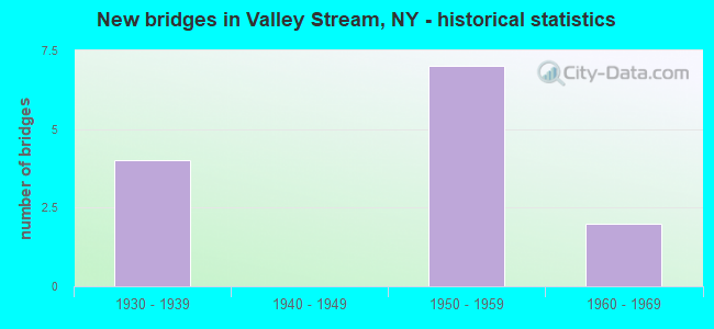
- New bridges - historical statistics
- 41930-1939
- 71950-1959
- 21960-1969
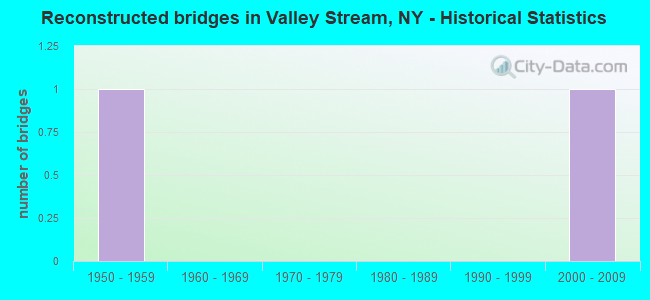
- Reconstructed bridges - Historical Statistics
- 11950-1959
- 01960-1969
- 01970-1979
- 01980-1989
- 01990-1999
- 12000-2009
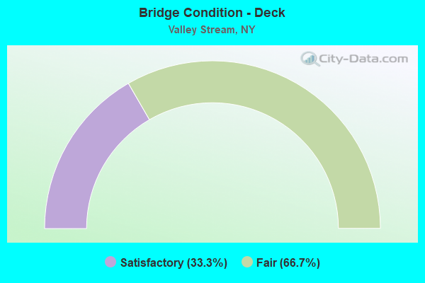
- Bridge Condition - Deck
- 33.3%Satisfactory
- 66.7%Fair
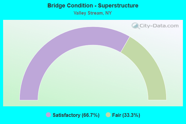
- Bridge Condition - Superstructure
- 66.7%Satisfactory
- 33.3%Fair
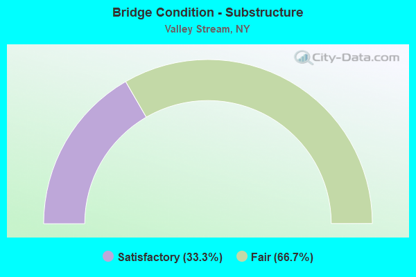
- Bridge Condition - Substructure
- 33.3%Satisfactory
- 66.7%Fair
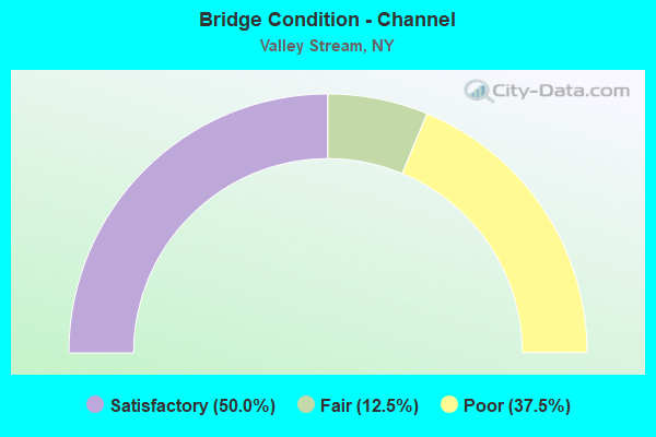
- Bridge Condition - Channel
- 50.0%Satisfactory
- 12.5%Fair
- 37.5%Poor
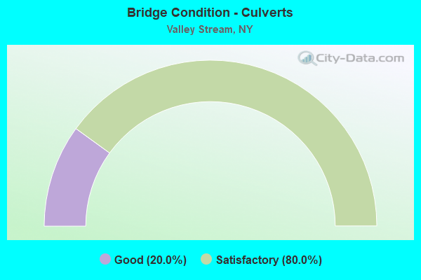
- Bridge Condition - Culverts
- 20.0%Good
- 80.0%Satisfactory
Find on map >> Show street view
Structure Number: 1056249, Location: 1.1 MI E NYC L-RTE 27 (Lat: 40.661411, Lng: -73.706917), Route carried "on" structure: State highway 27, Year Built: 1939, Year Reconstructed: 1957, Status: Open, Structure Length: 0.72m (2.36ft), Average Daily Traffic: 32,986 (year 2020), Truck Traffic: 5%, Average Future Daily Traffic: 38,059 (year 2040), Features Intersected: VALLEY STRM CULVT
Minimum Vertical Clearance: 30+ m (98+ ft), Kilometerpoint: 1.850, Lanes on structure: 6, Base Highway Network: Yes, Owner: State Highway Agency, Approaching Roadway Width: 35.4m (116.1ft), Skew: 20 degrees, Material/Design: Concrete continuous, Design/Construction: Culvert, Number Of Spans In Main Unit: 2, Length of Maximum Span: 3.0m (9.8ft), Curb or Sidewalk Widths: Left: 0.0m, Right: 3.0m (9.8ft)
Condition: Channel: Satisfactory, Culverts: Satisfactory, Operating Rating: 72.1 metric tons, Method Used To Determine Operating Rating: Field evaluation and documented engineering judgment, Inventory Rating: 32.7 metric tons, Method Used To Determine Inventory Rating: Field evaluation and documented engineering judgment, Structural Evaluation: Equal to present minimum criteria, Waterway Adequacy: Somewhat better than minimum adequacy, Approach Roadway Alignment: Equal to present desirable criteria, Length Of Structure Improvement: 0.71m (2.33ft), Designated Inspection Frequency: Every 24 months, Underwater Inspection Frequency: Every 60 months, Inspection Date: September 2021, Underwater Inspection Date: August 2016, Bridge Improvement Cost: $756,000, Roadway Improvement Cost: $443,000, Total Project Cost: $1,199,000 ( Estimate for 2021)
Find on map >> Show street view
Structure Number: 330006, Location: 0.2 MI. S JCT RTE 27&MILL (Lat: 40.658581, Lng: -73.709606), Route carried "on" structure: Other road , Year Built: 1964, Status: Open, Structure Length: 0.85m (2.79ft), Average Daily Traffic: 20,945 (year 2019), Truck Traffic: 2%, Average Future Daily Traffic: 25,443 (year 2040), Design Load: HS 20, Features Intersected: WATTS BROOK, Facility Carried by Structure: MILL ROAD
Minimum Vertical Clearance: 30+ m (98+ ft), Kilometerpoint: 2.317, Lanes on structure: 4, Owner: County Highway Agency, Approaching Roadway Width: 20.7m (67.9ft), Skew: 3 degrees, Material/Design: Concrete, Design/Construction: Tee Beam, Number Of Spans In Main Unit: 1, Length of Maximum Span: 7.9m (25.9ft), Curb or Sidewalk Widths: Left: 2.2m (7.2ft), Right: 2.2m (7.2ft), Curb-To-Curb Width: 20.9m (68.6ft), Out-to-Out Width: 25.8m (84.6ft)
Condition: Deck: Fair, Superstructure: Satisfactory, Substructure: Fair, Channel: Satisfactory, Operating Rating: 51.7 metric tons, Method Used To Determine Operating Rating: Load Factor (LF), Inventory Rating: 32.7 metric tons, Method Used To Determine Inventory Rating: Load Factor (LF), Structural Evaluation: Somewhat better than minimum adequacy, Deck Geometry: Superior to present desirable criteria, Waterway Adequacy: Somewhat better than minimum adequacy, Approach Roadway Alignment: Equal to present desirable criteria, Length Of Structure Improvement: 0.85m (2.79ft), Designated Inspection Frequency: Every 24 months, Inspection Date: Febuary 2020, Bridge Improvement Cost: $1,120,000, Roadway Improvement Cost: $656,000, Total Project Cost: $1,776,000 ( Estimate for 2021), Deck Structure Type: Concrete Cast-file-Place, Wearing Surface/Protective System: Wearing Surface: Bituminous
Find on map >> Show street view
Structure Number: 330007, Location: 0.6MI SE VALLEY STREAM (Lat: 40.655019, Lng: -73.698933), Route carried "on" structure: County highway , Year Built: 1952, Status: Open, Structure Length: 1.04m (3.41ft), Average Daily Traffic: 5,905 (year 2020), Truck Traffic: 4%, Average Future Daily Traffic: 7,173 (year 2040), Design Load: HS 20, Features Intersected: FOSTERS BROOK, Facility Carried by Structure: ROCKAWAY AVENUE
Minimum Vertical Clearance: 30+ m (98+ ft), Kilometerpoint: 1.335, Lanes on structure: 2, Owner: County Highway Agency, Approaching Roadway Width: 9.1m (29.9ft), Material/Design: Concrete continuous, Design/Construction: Culvert, Number Of Spans In Main Unit: 3, Length of Maximum Span: 3.3m (10.8ft), Curb or Sidewalk Widths: Left: 1.2m (3.9ft), Right: 1.2m (3.9ft)
Condition: Channel: Poor, Culverts: Satisfactory, Operating Rating: 51.7 metric tons, Method Used To Determine Operating Rating: Load Factor (LF), Inventory Rating: 30.8 metric tons, Method Used To Determine Inventory Rating: Load Factor (LF), Structural Evaluation: Equal to present minimum criteria, Waterway Adequacy: Meets minimum limits, Approach Roadway Alignment: Equal to present desirable criteria, Length Of Structure Improvement: 1.03m (3.38ft), Designated Inspection Frequency: Every 24 months, Inspection Date: Febuary 2020, Bridge Improvement Cost: $316,000, Roadway Improvement Cost: $185,000, Total Project Cost: $502,000 ( Estimate for 2021), Wearing Surface/Protective System: Wearing Surface: Bituminous
Find on map >> Show street view
Structure Number: 330017, Location: 1.7 MI S VALLEY STR (Lat: 40.651900, Lng: -73.708817), Route carried "on" structure: County highway , Year Built: 1951, Year Reconstructed: 2006, Status: Open, Structure Length: 1.55m (5.09ft), Average Daily Traffic: 17,148 (year 2019), Truck Traffic: 2%, Average Future Daily Traffic: 20,831 (year 2040), Design Load: HS 20, Features Intersected: FOSTERS BROOK, Facility Carried by Structure: MILL ROAD
Minimum Vertical Clearance: 30+ m (98+ ft), Kilometerpoint: 1.577, Lanes on structure: 5, Owner: County Highway Agency, Approaching Roadway Width: 19.5m (64.0ft), Material/Design: Concrete continuous, Design/Construction: Slab, Number Of Spans In Main Unit: 5, Length of Maximum Span: 2.7m (8.9ft), Curb or Sidewalk Widths: Left: 2.4m (7.9ft), Right: 2.2m (7.2ft), Curb-To-Curb Width: 19.5m (64.0ft), Out-to-Out Width: 25.1m (82.3ft)
Condition: Deck: Fair, Superstructure: Fair, Substructure: Fair, Channel: Fair, Operating Rating: 40.8 metric tons, Method Used To Determine Operating Rating: Load Factor (LF), Inventory Rating: 23.6 metric tons, Method Used To Determine Inventory Rating: Load Factor (LF), Structural Evaluation: Somewhat better than minimum adequacy, Deck Geometry: Meets minimum limits, Waterway Adequacy: Somewhat better than minimum adequacy, Approach Roadway Alignment: Equal to present desirable criteria, Length Of Structure Improvement: 1.55m (5.09ft), Designated Inspection Frequency: Every 24 months, Inspection Date: Febuary 2020, Bridge Improvement Cost: $1,152,000, Roadway Improvement Cost: $675,000, Total Project Cost: $1,827,000 ( Estimate for 2021), Wearing Surface/Protective System: Wearing Surface: Bituminous
Find on map >> Show street view
Structure Number: 330018, Location: 1.5 MI S VALLEY STR (Lat: 40.650681, Lng: -73.712247), Route carried "on" structure: County highway , Year Built: 1951, Status: Open, Structure Length: 1.55m (5.09ft), Average Daily Traffic: 11,266 (year 2019), Truck Traffic: 2%, Average Future Daily Traffic: 13,685 (year 2040), Design Load: HS 20, Features Intersected: FOSTERS BROOK, Facility Carried by Structure: BROOKFIELD ROAD
Minimum Vertical Clearance: 30+ m (98+ ft), Kilometerpoint: 1.110, Lanes on structure: 4, Owner: County Highway Agency, Approaching Roadway Width: 17.8m (58.4ft), Skew: 21 degrees, Material/Design: Concrete, Design/Construction: Slab, Number Of Spans In Main Unit: 5, Length of Maximum Span: 3.0m (9.8ft), Curb or Sidewalk Widths: Left: 2.0m (6.6ft), Right: 2.0m (6.6ft), Curb-To-Curb Width: 17.8m (58.4ft), Out-to-Out Width: 22.6m (74.1ft)
Condition: Deck: Satisfactory, Superstructure: Satisfactory, Substructure: Satisfactory, Channel: Poor, Operating Rating: 38.1 metric tons, Method Used To Determine Operating Rating: Load Factor (LF), Inventory Rating: 22.7 metric tons, Method Used To Determine Inventory Rating: Load Factor (LF), Structural Evaluation: Somewhat better than minimum adequacy, Deck Geometry: Somewhat better than minimum adequacy, Waterway Adequacy: Meets minimum limits, Approach Roadway Alignment: Equal to present desirable criteria, Length Of Structure Improvement: 1.55m (5.09ft), Designated Inspection Frequency: Every 24 months, Inspection Date: Febuary 2020, Bridge Improvement Cost: $1,036,000, Roadway Improvement Cost: $607,000, Total Project Cost: $1,643,000 ( Estimate for 2021)
Find on map >> Show street view
Structure Number: 330032, Location: 1.0 MI S VALLEY STREAM (Lat: 40.653378, Lng: -73.701069), Route carried "on" structure: Other road , Year Built: 1952, Status: Open, Structure Length: 1.04m (3.41ft), Average Daily Traffic: 384 (year 2020), Truck Traffic: 1%, Average Future Daily Traffic: 475 (year 2040), Design Load: HS 20, Features Intersected: FOSTERS BROOK, Facility Carried by Structure: GIBSON BOULEVARD
Minimum Vertical Clearance: 30+ m (98+ ft), Kilometerpoint: 0.933, Lanes on structure: 2, Owner: County Highway Agency, Approaching Roadway Width: 9.1m (29.9ft), Skew: 4 degrees, Material/Design: Concrete continuous, Design/Construction: Culvert, Number Of Spans In Main Unit: 3, Length of Maximum Span: 3.3m (10.8ft), Curb or Sidewalk Widths: Left: 1.2m (3.9ft), Right: 1.2m (3.9ft), Curb-To-Curb Width: 9.1m (29.9ft), Out-to-Out Width: 15.7m (51.5ft)
Condition: Channel: Satisfactory, Culverts: Satisfactory, Operating Rating: 48.1 metric tons, Method Used To Determine Operating Rating: Load Factor (LF), Inventory Rating: 28.1 metric tons, Method Used To Determine Inventory Rating: Load Factor (LF), Structural Evaluation: Equal to present minimum criteria, Deck Geometry: Equal to present minimum criteria, Waterway Adequacy: Meets minimum limits, Approach Roadway Alignment: Equal to present desirable criteria, Length Of Structure Improvement: 1.03m (3.38ft), Designated Inspection Frequency: Every 24 months, Inspection Date: January 2020, Bridge Improvement Cost: $561,000, Roadway Improvement Cost: $329,000, Total Project Cost: $890,000 ( Estimate for 2021)
Find on map >> Show street view
Structure Number: 330033, Location: 1 MI S OF VALLEY STREAM (Lat: 40.652581, Lng: -73.702333), Route carried "on" structure: Other road , Year Built: 1952, Status: Open, Structure Length: 0.79m (2.59ft), Average Daily Traffic: 1,989 (year 2018), Truck Traffic: 3%, Average Future Daily Traffic: 2,460 (year 2040), Design Load: HS 20, Features Intersected: FOSTERS BROOK, Facility Carried by Structure: COCHRANE PLACE
Minimum Vertical Clearance: 30+ m (98+ ft), Kilometerpoint: 0.676, Lanes on structure: 2, Owner: County Highway Agency, Approaching Roadway Width: 9.1m (29.9ft), Skew: 3 degrees, Material/Design: Concrete continuous, Design/Construction: Culvert, Number Of Spans In Main Unit: 3, Length of Maximum Span: 2.4m (7.9ft), Curb or Sidewalk Widths: Left: 1.2m (3.9ft), Right: 1.2m (3.9ft)
Condition: Channel: Poor, Culverts: Good, Operating Rating: 48.1 metric tons, Method Used To Determine Operating Rating: Load Factor (LF), Inventory Rating: 28.1 metric tons, Method Used To Determine Inventory Rating: Load Factor (LF), Structural Evaluation: Better than present minimum criteria, Waterway Adequacy: Somewhat better than minimum adequacy, Approach Roadway Alignment: Equal to present desirable criteria, Length Of Structure Improvement: 0.79m (2.59ft), Designated Inspection Frequency: Every 24 months, Inspection Date: Febuary 2020, Bridge Improvement Cost: $298,000, Roadway Improvement Cost: $174,000, Total Project Cost: $472,000 ( Estimate for 2021)
Find on map >> Show street view
Structure Number: 330039, Location: 1 MI S OF VALLEY STREAM (Lat: 40.645239, Lng: -73.701278), Route carried "on" structure: City street , Year Built: 1964, Status: Posted for load, Structure Length: 0.64m (2.10ft), Average Daily Traffic: 3,583 (year 2020), Truck Traffic: 1%, Average Future Daily Traffic: 4,433 (year 2040), Features Intersected: DOXEY BROOK, Facility Carried by Structure: GIBSON BOULEVARD
Minimum Vertical Clearance: 30+ m (98+ ft), Kilometerpoint: 0.064, Lanes on structure: 4, Owner: County Highway Agency, Approaching Roadway Width: 14.6m (47.9ft), Skew: 1 degrees, Material/Design: Concrete, Design/Construction: Culvert, Number Of Spans In Main Unit: 2, Length of Maximum Span: 3.0m (9.8ft), Curb or Sidewalk Widths: Left: 1.2m (3.9ft), Right: 1.2m (3.9ft)
Condition: Channel: Satisfactory, Culverts: Satisfactory, Operating Rating: 38.1 metric tons, Method Used To Determine Operating Rating: Load Factor (LF), Inventory Rating: 22.7 metric tons, Method Used To Determine Inventory Rating: Load Factor (LF), Structural Evaluation: Equal to present minimum criteria, Waterway Adequacy: Meets minimum limits, Approach Roadway Alignment: Equal to present desirable criteria, Bridge Posting: Required (Relationship of Operating Rating to Maximum Legal Load: > 39.9% below), Length Of Structure Improvement: 0.64m (2.10ft), Designated Inspection Frequency: Every 12 months, Inspection Date: July 2021, Bridge Improvement Cost: $449,000, Roadway Improvement Cost: $263,000, Total Project Cost: $711,000 ( Estimate for 2021)
Find on map >> Show street view
Structure Number: 706122, Location: 1.5 MI W OF LYNBROOK (Lat: 40.659692, Lng: -73.701747), Route carried "under" structure: State highway 27, Year Built: 1933, Structure Length: 0. m, Average Daily Traffic: 47,329 (year 2000), Features Intersected: RTE 27, Facility Carried by Structure: LIRR FAR ROCK BR
Minimum Vertical Clearance: 4.27m (14.01ft), Kilometerpoint: 2.365, Lanes under structure: 8, Material/Design: Steel, Design/Construction: Stringer/Multi-beam, Length of Maximum Span: 23.4m (76.8ft)
Find on map >> Show street view
Structure Number: 77097, Location: 0.7 MI W OF VALLEY STREAM (Lat: 40.664803, Lng: -73.716142), Route carried "under" structure: Other road , Year Built: 1951, Structure Length: 0. m, Average Daily Traffic: 7,000 (year 1978), Features Intersected: TERRACE PL, Facility Carried by Structure: LIRR MONTAUK BR
Minimum Vertical Clearance: 4.34m (14.24ft), Kilometerpoint: 0.000, Lanes under structure: 2, Material/Design: Steel, Design/Construction: Girder and Floorbeam System, Length of Maximum Span: 19.8m (65.0ft)
Find on map >> Show street view
Structure Number: 770971, Location: 0.4 MI W OF VALLEY STREAM (Lat: 40.662744, Lng: -73.708764), Route carried "under" structure: County highway , Year Built: 1951, Structure Length: 0. m, Average Daily Traffic: 22,000 (year 1977), Features Intersected: CENTRAL AVE, Facility Carried by Structure: LIRR MONTAUK BR
Minimum Vertical Clearance: 4.14m (13.58ft), Kilometerpoint: 0.000, Lanes under structure: 4, Material/Design: Steel, Design/Construction: Girder and Floorbeam System, Length of Maximum Span: 20.4m (66.9ft)
Find on map >> Show street view
Structure Number: 770972, Location: AT VALLEY STREAM (Lat: 40.661192, Lng: -73.703142), Route carried "under" structure: Other road , Year Built: 1933, Structure Length: 0. m, Average Daily Traffic: 13,000 (year 1978), Features Intersected: FRANKLIN AVE, Facility Carried by Structure: LIRR MONTAUK BR
Minimum Vertical Clearance: 3.98m (13.06ft), Kilometerpoint: 0.000, Lanes under structure: 4, Material/Design: Steel, Design/Construction: Stringer/Multi-beam, Length of Maximum Span: 13.1m (43.0ft)
Find on map >> Show street view
Structure Number: 770973A, Location: AT VALLEY STREAM (Lat: 40.662789, Lng: -73.690850), Route carried "under" structure: County highway , Year Built: 1933, Structure Length: 0. m, Average Daily Traffic: 100 (year 2021), Features Intersected: MERRICK RD, Facility Carried by Structure: LIRR W HEMPSTEAD
Minimum Vertical Clearance: 4.34m (14.24ft), Kilometerpoint: 0.000, Lanes under structure: 8, Material/Design: Steel, Design/Construction: Stringer/Multi-beam, Length of Maximum Span: 19.5m (64.0ft)