Bridge Statistics for Valley View, Ohio (OH)
Condition, Traffic, Stress, Structural Evaluation, Project Costs
- National Bridge Inventory (NBI) Statistics
- 13Number of bridges
- 190ft / 58.0mTotal length
- $573,000Total costs
- 125,984Total average daily traffic
- 6,580Total average daily truck traffic
- National Bridge Inventory (NBI) Registered Bridges for Valley View
- No street view available for this location
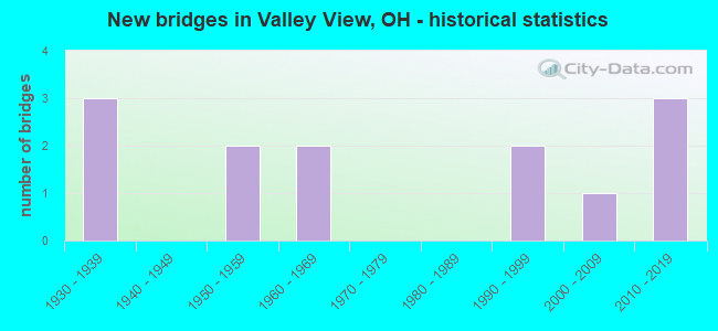
- New bridges - historical statistics
- 31930-1939
- 21950-1959
- 21960-1969
- 21990-1999
- 12000-2009
- 32010-2019


- Bridge Condition - Deck
- 36.4%Very good
- 27.3%Good
- 18.2%Satisfactory
- 9.1%Fair
- 9.1%Poor

- Bridge Condition - Superstructure
- 9.1%Excellent
- 27.3%Very good
- 27.3%Good
- 18.2%Satisfactory
- 9.1%Poor
- 9.1%Serious

- Bridge Condition - Substructure
- 18.2%Very good
- 36.4%Good
- 27.3%Satisfactory
- 18.2%Fair

- Bridge Condition - Channel
- 11.1%Excellent
- 22.2%Very good
- 11.1%Good
- 33.3%Satisfactory
- 11.1%Poor
- 11.1%Serious
Find on map >> Show street view
Structure Number: 1802526, Location: APPROX 1000FT E I-77 (Lat: 41.414031, Lng: -81.640550), Route carried "on" structure: State highway 21, Year Built: 1939, Status: Open, Structure Length: 1.89m (6.20ft), Average Daily Traffic: 12,652 (year 2015), Truck Traffic: 4%, Average Future Daily Traffic: 17,561 (year 2035), Design Load: H 20, Features Intersected: SR-17, (CUY-17-1453)
Minimum Vertical Clearance: 30+ m (98+ ft), Kilometerpoint: 15.418, Lanes on structure: 4, Lanes under structure: 4, Owner: State Highway Agency, Approaching Roadway Width: 13.7m (44.9ft), Material/Design: Concrete, Design/Construction: Frame, Number Of Spans In Main Unit: 1, Length of Maximum Span: 16.5m (54.1ft), Curb or Sidewalk Widths: Left: 0.7m (2.3ft), Right: 0.7m (2.3ft), Curb-To-Curb Width: 13.4m (44.0ft), Out-to-Out Width: 16.0m (52.5ft)
Condition: Deck: Fair, Superstructure: Satisfactory, Substructure: Good, Operating Rating: 42.1 metric tons, Method Used To Determine Operating Rating: Load Factor (LF) rating reported by rating factor (RF) method using MS18 loading, Inventory Rating: 32.4 metric tons, Method Used To Determine Inventory Rating: Load Factor (LF) rating reported by rating factor (RF) method using MS18 loading, Structural Evaluation: Equal to present minimum criteria, Deck Geometry: High priority of replacement, Underclear: High priority of corrective action, Approach Roadway Alignment: Equal to present desirable criteria, Designated Inspection Frequency: Every 12 months, Inspection Date: May 2021, Deck Structure Type: Concrete Cast-file-Place, Wearing Surface/Protective System: Wearing Surface: Integral Concrete
Find on map >> Show street view
Structure Number: 1802585, Location: APPROX 500 FT E SR21 (Lat: 41.414061, Lng: -81.637939), Route carried "on" structure: State highway 17, Year Built: 1939, Year Reconstructed: 1993, Status: Open, Structure Length: 7.07m (23.20ft), Average Daily Traffic: 14,111 (year 2015), Truck Traffic: 4%, Average Future Daily Traffic: 19,586 (year 2035), Design Load: HS 20+Mod, Features Intersected: CUYAHOGA RIVER
Minimum Vertical Clearance: 30+ m (98+ ft), Kilometerpoint: 23.577, Lanes on structure: 4, Owner: State Highway Agency, Approaching Roadway Width: 14.0m (45.9ft), Skew: 3 degrees, Material/Design: Steel continuous, Design/Construction: Stringer/Multi-beam, Number Of Spans In Main Unit: 3, Length of Maximum Span: 28.7m (94.2ft), Curb or Sidewalk Widths: Left: 1.5m (4.9ft), Right: 1.5m (4.9ft), Curb-To-Curb Width: 14.0m (45.9ft), Out-to-Out Width: 17.7m (58.1ft)
Condition: Deck: Very good, Superstructure: Very good, Substructure: Good, Channel: Satisfactory, Operating Rating: 42.1 metric tons, Method Used To Determine Operating Rating: Load and Resistance Factor Rating (LRFR) rating reported by rating factor(RF) method using HL-93 loadings, Inventory Rating: 32.4 metric tons, Method Used To Determine Inventory Rating: Load and Resistance Factor Rating (LRFR) rating reported by rating factor(RF) method using HL-93 loadings, Structural Evaluation: Better than present minimum criteria, Deck Geometry: High priority of replacement, Waterway Adequacy: Better than present minimum criteria, Approach Roadway Alignment: Equal to present minimum criteria, Length Of Structure Improvement: 4.57m (14.99ft), Designated Inspection Frequency: Every 24 months, Inspection Date: November 2021, Bridge Improvement Cost: $360,000, Roadway Improvement Cost: $40,000, Total Project Cost: $400,000, Deck Structure Type: Concrete Cast-file-Place, Wearing Surface/Protective System: Wearing Surface: Latex Concrete, Deck Protection: Epoxy Coated Reinforcing
Find on map >> Show street view
Structure Number: 1802623, Location: 0.44 MI. E. OF JCT SR 21 (Lat: 41.414200, Lng: -81.632450), Route carried "on" structure: State highway 17, Year Built: 1993, Status: Open, Structure Length: 1.13m (3.71ft), Average Daily Traffic: 14,111 (year 2015), Truck Traffic: 4%, Average Future Daily Traffic: 19,586 (year 2035), Design Load: HS 20+Mod, Features Intersected: OHIO CANAL .4 MI E 21
Minimum Vertical Clearance: 30+ m (98+ ft), Kilometerpoint: 24.092, Lanes on structure: 4, Owner: State Highway Agency, Approaching Roadway Width: 15.2m (49.9ft), Skew: 3 degrees, Material/Design: Concrete, Design/Construction: Slab, Number Of Spans In Main Unit: 1, Length of Maximum Span: 10.4m (34.1ft), Curb or Sidewalk Widths: Left: 1.5m (4.9ft), Right: 1.5m (4.9ft), Curb-To-Curb Width: 15.4m (50.5ft), Out-to-Out Width: 19.1m (62.7ft)
Condition: Deck: Good, Superstructure: Good, Substructure: Satisfactory, Channel: Satisfactory, Operating Rating: 42.1 metric tons, Method Used To Determine Operating Rating: Load Factor (LF) rating reported by rating factor (RF) method using MS18 loading, Inventory Rating: 32.4 metric tons, Method Used To Determine Inventory Rating: Load Factor (LF) rating reported by rating factor (RF) method using MS18 loading, Structural Evaluation: Equal to present minimum criteria, Deck Geometry: Meets minimum limits, Waterway Adequacy: Better than present minimum criteria, Approach Roadway Alignment: Equal to present desirable criteria, Designated Inspection Frequency: Every 24 months, Inspection Date: November 2021, Deck Structure Type: Concrete Cast-file-Place, Wearing Surface/Protective System: Wearing Surface: Latex Concrete, Deck Protection: Epoxy Coated Reinforcing
Find on map >> Show street view
Structure Number: 1830295, Location: 2700 FT W OF TURNEY RD (Lat: 41.396511, Lng: -81.602450), Route carried "on" structure: County highway 53, Year Built: 1964, Status: Open, Structure Length: 4.56m (14.96ft), Average Daily Traffic: 10,769 (year 2015), Truck Traffic: 7%, Average Future Daily Traffic: 14,947 (year 2035), Design Load: HS 20+Mod, Features Intersected: FORMER P&LE RW/ACCESS RD
Minimum Vertical Clearance: 30+ m (98+ ft), Kilometerpoint: 7.725, Lanes on structure: 4, Base Highway Network: Yes, Owner: County Highway Agency, Approaching Roadway Width: 15.9m (52.2ft), Material/Design: Steel continuous, Design/Construction: Stringer/Multi-beam, Number Of Spans In Main Unit: 3, Length of Maximum Span: 18.3m (60.0ft), Curb or Sidewalk Widths: Left: 1.2m (3.9ft), Right: 1.2m (3.9ft), Curb-To-Curb Width: 15.9m (52.2ft), Out-to-Out Width: 17.4m (57.1ft)
Condition: Deck: Satisfactory, Superstructure: Satisfactory, Substructure: Fair, Operating Rating: 67.7 metric tons, Method Used To Determine Operating Rating: Load Factor (LF) rating reported by rating factor (RF) method using MS18 loading, Inventory Rating: 40.8 metric tons, Method Used To Determine Inventory Rating: Load Factor (LF) rating reported by rating factor (RF) method using MS18 loading, Structural Evaluation: Somewhat better than minimum adequacy, Deck Geometry: Meets minimum limits, Approach Roadway Alignment: Equal to present desirable criteria, Designated Inspection Frequency: Every 12 months, Inspection Date: September 2021, Deck Structure Type: Concrete Cast-file-Place, Wearing Surface/Protective System: Wearing Surface: Integral Concrete
Find on map >> Show street view
Structure Number: 1830465, Location: AT CANAL RD (Lat: 41.359389, Lng: -81.598681), Route carried "on" structure: County highway 39, Year Built: 1958, Status: Open, Structure Length: 19.42m (63.71ft), Average Daily Traffic: 14,182 (year 2015), Truck Traffic: 12%, Average Future Daily Traffic: 19,685 (year 2035), Design Load: HS 20, Features Intersected: CANAL RD, OH CANAL/METRO
Minimum Vertical Clearance: 30+ m (98+ ft), Kilometerpoint: 15.578, Lanes on structure: 2, Lanes under structure: 2, Owner: County Highway Agency, Approaching Roadway Width: 13.7m (44.9ft), Skew: 3 degrees, Material/Design: Steel continuous, Design/Construction: Stringer/Multi-beam, Number Of Spans In Main Unit: 9, Length of Maximum Span: 23.2m (76.1ft), Curb or Sidewalk Widths: Left: 1.3m (4.3ft), Right: 1.3m (4.3ft), Curb-To-Curb Width: 8.5m (27.9ft), Out-to-Out Width: 11.2m (36.7ft)
Condition: Deck: Poor, Superstructure: Poor, Substructure: Fair, Channel: Poor, Operating Rating: 56.1 metric tons, Method Used To Determine Operating Rating: Load Factor (LF) rating reported by rating factor (RF) method using MS18 loading, Inventory Rating: 33.7 metric tons, Method Used To Determine Inventory Rating: Load Factor (LF) rating reported by rating factor (RF) method using MS18 loading, Structural Evaluation: Meets minimum limits, Deck Geometry: Meets minimum limits, Underclear: Somewhat better than minimum adequacy, Waterway Adequacy: Superior to present desirable criteria, Approach Roadway Alignment: Equal to present desirable criteria, Designated Inspection Frequency: Every 12 months, Inspection Date: September 2021, Deck Structure Type: Concrete Cast-file-Place, Wearing Surface/Protective System: Wearing Surface: Integral Concrete
Find on map >> Show street view
Structure Number: 1832476, Location: 322' WEST OF CANAL ROAD (Lat: 41.393700, Lng: -81.627900), Route carried "on" structure: County highway 53, Year Built: 2010, Status: Open, Structure Length: 1.80m (5.91ft), Average Daily Traffic: 19,339 (year 2015), Truck Traffic: 7%, Average Future Daily Traffic: 26,843 (year 2035), Design Load: HL 93, Features Intersected: OHIO/ERIE CANAL & TRAIL
Minimum Vertical Clearance: 30+ m (98+ ft), Kilometerpoint: 5.488, Lanes on structure: 5, Base Highway Network: Yes, Owner: County Highway Agency, Approaching Roadway Width: 19.2m (63.0ft), Material/Design: Prestressed concrete, Design/Construction: Stringer/Multi-beam, Number Of Spans In Main Unit: 1, Length of Maximum Span: 17.1m (56.1ft), Curb or Sidewalk Widths: Left: 1.8m (5.9ft), Right: 1.8m (5.9ft), Curb-To-Curb Width: 19.2m (63.0ft), Out-to-Out Width: 23.5m (77.1ft)
Condition: Deck: Very good, Superstructure: Excellent, Substructure: Very good, Channel: Excellent, Operating Rating: 54.8 metric tons, Method Used To Determine Operating Rating: Load and Resistance Factor Rating (LRFR) rating reported by rating factor(RF) method using HL-93 loadings, Inventory Rating: 30.8 metric tons, Method Used To Determine Inventory Rating: Load and Resistance Factor Rating (LRFR) rating reported by rating factor(RF) method using HL-93 loadings, Structural Evaluation: Better than present minimum criteria, Deck Geometry: Meets minimum limits, Waterway Adequacy: Superior to present desirable criteria, Approach Roadway Alignment: Equal to present desirable criteria, Designated Inspection Frequency: Every 24 months, Inspection Date: June 2021, Deck Structure Type: Concrete Cast-file-Place, Wearing Surface/Protective System: Wearing Surface: Monolithic Concrete, Deck Protection: Epoxy Coated Reinforcing
Find on map >> Show street view
Structure Number: 1832883, Location: 8126' E.OF BRECKSVILLE RD (Lat: 41.372969, Lng: -81.612819), Route carried "on" structure: County highway C0145, Year Built: 2003, Status: Open, Structure Length: 2.67m (8.76ft), Average Daily Traffic: 2,343 (year 2015), Truck Traffic: 4%, Average Future Daily Traffic: 3,252 (year 2035), Design Load: HS 20+Mod, Features Intersected: OHIO CANAL, Facility Carried by Structure: HILLSIDE RD CR 145
Minimum Vertical Clearance: 30+ m (98+ ft), Kilometerpoint: 6.325, Lanes on structure: 2, Owner: County Highway Agency, Approaching Roadway Width: 7.3m (24.0ft), Skew: 1 degrees, Material/Design: Concrete continuous, Design/Construction: Slab, Number Of Spans In Main Unit: 3, Length of Maximum Span: 9.9m (32.5ft), Curb or Sidewalk Widths: Left: 1.8m (5.9ft), Right: 1.8m (5.9ft), Curb-To-Curb Width: 7.3m (24.0ft), Out-to-Out Width: 11.5m (37.7ft)
Condition: Deck: Very good, Superstructure: Very good, Substructure: Very good, Channel: Very good, Operating Rating: 59.6 metric tons, Method Used To Determine Operating Rating: Load Factor (LF) rating reported by rating factor (RF) method using MS18 loading, Inventory Rating: 35.6 metric tons, Method Used To Determine Inventory Rating: Load Factor (LF) rating reported by rating factor (RF) method using MS18 loading, Structural Evaluation: Equal to present desirable criteria, Deck Geometry: High priority of replacement, Waterway Adequacy: Superior to present desirable criteria, Approach Roadway Alignment: Equal to present desirable criteria, Designated Inspection Frequency: Every 24 months, Inspection Date: August 2021, Deck Structure Type: Concrete Cast-file-Place, Wearing Surface/Protective System: Wearing Surface: Integral Concrete, Deck Protection: Epoxy Coated Reinforcing
Find on map >> Show street view
Structure Number: 183298, Location: 1000' S TINKERS CREEK RD (Lat: 41.364950, Lng: -81.608711), Route carried "on" structure: County highway C0082, Year Built: 1993, Status: Open, Structure Length: 3.70m (12.14ft), Average Daily Traffic: 7,497 (year 2015), Truck Traffic: 2%, Average Future Daily Traffic: 10,406 (year 2035), Design Load: HS 20+Mod, Features Intersected: TINKERS CREEK, Facility Carried by Structure: CANAL ROAD CR 82
Minimum Vertical Clearance: 30+ m (98+ ft), Kilometerpoint: 2.157, Lanes on structure: 2, Owner: County Highway Agency, Approaching Roadway Width: 11.0m (36.1ft), Material/Design: Prestressed concrete continuous, Design/Construction: Box Beam or Girders - Multiple, Number Of Spans In Main Unit: 2, Length of Maximum Span: 17.1m (56.1ft), Curb-To-Curb Width: 12.2m (40.0ft), Out-to-Out Width: 12.2m (40.0ft)
Condition: Deck: Very good, Superstructure: Very good, Substructure: Satisfactory, Channel: Serious, Operating Rating: 65.4 metric tons, Method Used To Determine Operating Rating: Load Factor (LF) rating reported by rating factor (RF) method using MS18 loading, Inventory Rating: 39.2 metric tons, Method Used To Determine Inventory Rating: Load Factor (LF) rating reported by rating factor (RF) method using MS18 loading, Structural Evaluation: Equal to present minimum criteria, Deck Geometry: Somewhat better than minimum adequacy, Waterway Adequacy: Equal to present desirable criteria, Approach Roadway Alignment: Equal to present desirable criteria, Designated Inspection Frequency: Every 12 months, Inspection Date: July 2021, Deck Structure Type: Concrete Cast-file-Place, Wearing Surface/Protective System: Wearing Surface: Latex Concrete, Deck Protection: Epoxy Coated Reinforcing
Find on map >> Show street view
Structure Number: 1887122, Location: 60 FT W OF CANAL ROAD (Lat: 41.404111, Lng: -81.627089), Route carried "on" structure: City street FOSOI, Year Built: 1965, Year Reconstructed: 1987, Status: Posted for load, Structure Length: 2.51m (8.23ft), Average Daily Traffic: 9,331 (year 2015), Truck Traffic: 2%, Average Future Daily Traffic: 12,951 (year 2035), Design Load: HS 20, Features Intersected: OHIO CANAL, Facility Carried by Structure: FOSDICK ROAD
Minimum Vertical Clearance: 30+ m (98+ ft), Kilometerpoint: 0.018, Lanes on structure: 2, Owner: City or Municipal Highway Agency, Approaching Roadway Width: 9.1m (29.9ft), Material/Design: Steel, Design/Construction: Stringer/Multi-beam, Number Of Spans In Main Unit: 3, Length of Maximum Span: 9.1m (29.9ft), Curb-To-Curb Width: 9.1m (29.9ft), Out-to-Out Width: 10.1m (33.1ft)
Condition: Deck: Satisfactory, Superstructure: Serious, Substructure: Satisfactory, Channel: Good, Operating Rating: 12.6 metric tons, Method Used To Determine Operating Rating: Load and Resistance Factor Rating (LRFR) rating reported by rating factor(RF) method using HL-93 loadings, Inventory Rating: 9.7 metric tons, Method Used To Determine Inventory Rating: Load and Resistance Factor Rating (LRFR) rating reported by rating factor(RF) method using HL-93 loadings, Structural Evaluation: High priority of corrective action, Deck Geometry: High priority of corrective action, Waterway Adequacy: Somewhat better than minimum adequacy, Approach Roadway Alignment: Somewhat better than minimum adequacy, Bridge Posting: Required (Relationship of Operating Rating to Maximum Legal Load: > 39.9% below), Designated Inspection Frequency: Every 12 months, Inspection Date: October 2021, Deck Structure Type: Concrete Cast-file-Place, Wearing Surface/Protective System: Wearing Surface: Monolithic Concrete, Deck Protection: Epoxy Coated Reinforcing
Find on map >> Show street view
Structure Number: 6160035P, Location: 0.1 MILES FROM CANAL ROAD (Lat: 41.357083, Lng: -81.597556), Route carried "on" structure: Other road , Year Built: 2010, Status: Open, Structure Length: 8.23m (27.00ft), Average Daily Traffic: 40 (year 2010), Truck Traffic: 1%, Average Future Daily Traffic: 50 (year 2030), Features Intersected: CUYAHOGA RIVER, Facility Carried by Structure: FITZWATER ROAD
Minimum Vertical Clearance: 7.16m (23.49ft), Kilometerpoint: 0.000, Lanes on structure: 2, Owner: National Park Service, Approaching Roadway Width: 7.9m (25.9ft), Material/Design: Prestressed concrete continuous, Design/Construction: Stringer/Multi-beam, Number Of Spans In Main Unit: 3, Length of Maximum Span: 36.6m (120.1ft), Curb or Sidewalk Widths: Left: 2.1m (6.9ft), Right: 0.0m, Curb-To-Curb Width: 8.0m (26.2ft), Out-to-Out Width: 11.1m (36.4ft)
Condition: Deck: Good, Superstructure: Good, Substructure: Good, Channel: Satisfactory, Structural Evaluation: Better than present minimum criteria, Deck Geometry: Equal to present minimum criteria, Waterway Adequacy: Equal to present desirable criteria, Approach Roadway Alignment: Equal to present desirable criteria, Designated Inspection Frequency: Every 24 months, Inspection Date: September 2020, Bridge Improvement Cost: $40,000, Roadway Improvement Cost: $4,000, Total Project Cost: $60,000 ( Estimate for 2018), Deck Structure Type: Concrete Cast-file-Place, Wearing Surface/Protective System: Deck Protection: Epoxy Coated Reinforcing
Find on map >> Show street view
Structure Number: 6160036P, Location: 100 FEET FROM CANAL ROAD. (Lat: 41.357028, Lng: -81.597000), Route carried "on" structure: Other road , Year Built: 2010, Status: Open, Structure Length: 5.05m (16.57ft), Average Daily Traffic: 40 (year 2010), Truck Traffic: 1%, Average Future Daily Traffic: 50 (year 2030), Features Intersected: CANAL FLUME, Facility Carried by Structure: FITZWATER ROAD
Minimum Vertical Clearance: 30+ m (98+ ft), Kilometerpoint: 0.000, Lanes on structure: 2, Owner: National Park Service, Approaching Roadway Width: 7.9m (25.9ft), Material/Design: Prestressed concrete continuous, Design/Construction: Stringer/Multi-beam, Number Of Spans In Main Unit: 2, Length of Maximum Span: 25.2m (82.7ft), Curb or Sidewalk Widths: Left: 2.1m (6.9ft), Right: 0.0m, Curb-To-Curb Width: 8.0m (26.2ft), Out-to-Out Width: 11.1m (36.4ft)
Condition: Deck: Good, Superstructure: Good, Substructure: Good, Channel: Very good, Inventory Rating: 87.1 metric tons, Method Used To Determine Inventory Rating: Load and Resistance Factor (LRFR), Structural Evaluation: Better than present minimum criteria, Deck Geometry: Equal to present minimum criteria, Waterway Adequacy: Equal to present desirable criteria, Approach Roadway Alignment: Equal to present desirable criteria, Designated Inspection Frequency: Every 24 months, Inspection Date: September 2020, Bridge Improvement Cost: $75,000, Roadway Improvement Cost: $8,000, Total Project Cost: $113,000 ( Estimate for 2018), Deck Structure Type: Concrete Cast-file-Place, Wearing Surface/Protective System: Deck Protection: Epoxy Coated Reinforcing
Find on map >> Show street view
Structure Number: 1802526, Location: APPROX 1000FT E I-77 (Lat: 41.414031, Lng: -81.640550), Route carried "under" structure: State highway 17, Year Built: 1939, Structure Length: 0. m, Average Daily Traffic: 14,072 (year 2015), Truck Traffic: 4%, Features Intersected: SR-21(0958)BRECKSVILLE R, Facility Carried by Structure: SR 21
Minimum Vertical Clearance: 4.32m (14.17ft), Kilometerpoint: 23.384, Lanes on structure: 4, Lanes under structure: 4, Material/Design: Concrete, Design/Construction: Frame, Length of Maximum Span: 16.5m (54.1ft)
Find on map >> Show street view
Structure Number: 1830465, Location: AT CANAL RD (Lat: 41.359389, Lng: -81.598681), Route carried "under" structure: Alternate County highway 82, Year Built: 1958, Structure Length: 0. m, Average Daily Traffic: 7,497 (year 2015), Truck Traffic: 2%, Features Intersected: CANAL ROAD, Facility Carried by Structure: PLEASANT VALLY C39
Minimum Vertical Clearance: 4.67m (15.32ft), Kilometerpoint: 32.670, Lanes on structure: 2, Lanes under structure: 2, Material/Design: Steel continuous, Design/Construction: Stringer/Multi-beam, Length of Maximum Span: 23.2m (76.1ft)