Bridge Statistics for Van Buren, Missouri (MO)
Condition, Traffic, Stress, Structural Evaluation, Project Costs
- National Bridge Inventory (NBI) Statistics
- 15Number of bridges
- 433ft / 132mTotal length
- $18,000Total costs
- 52,728Total average daily traffic
- 12,228Total average daily truck traffic
- 89,318Total future (year 2030) average daily traffic
- National Bridge Inventory (NBI) Registered Bridges for Van Buren
- No street view available for this location
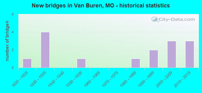
- New bridges - historical statistics
- 11920-1929
- 41930-1939
- 11950-1959
- 11980-1989
- 21990-1999
- 32000-2009
- 32010-2019

- Reconstructed bridges - Historical Statistics
- 11930-1939
- 01940-1949
- 01950-1959
- 01960-1969
- 01970-1979
- 01980-1989
- 01990-1999
- 12000-2009


- Bridge Condition - Deck
- 37.5%Very good
- 37.5%Good
- 25.0%Satisfactory

- Bridge Condition - Superstructure
- 12.5%Excellent
- 37.5%Very good
- 12.5%Good
- 12.5%Satisfactory
- 25.0%Fair

- Bridge Condition - Substructure
- 50.0%Very good
- 25.0%Good
- 12.5%Satisfactory
- 12.5%Fair

- Bridge Condition - Channel
- 33.3%Good
- 53.3%Satisfactory
- 13.3%Fair

- Bridge Condition - Culverts
- 14.3%Good
- 85.7%Satisfactory
Find on map >> Show street view
Structure Number: 29147, Location: S 4 T 27 N R 1 E (Lat: 37.037864, Lng: -90.954692), Route carried "on" structure: US 60, Year Built: 2002, Status: Open, Structure Length: 7.41m (24.31ft), Average Daily Traffic: 2,806 (year 2021), Truck Traffic: 29%, Average Future Daily Traffic: 5,331 (year 2041), Design Load: HS 25 or greater, Features Intersected: CARTER CR
Minimum Vertical Clearance: 30+ m (98+ ft), Kilometerpoint: 369.508, Lanes on structure: 2, Base Highway Network: Yes, Owner: State Highway Agency, Approaching Roadway Width: 11.6m (38.1ft), Skew: 2 degrees, Material/Design: Prestressed concrete continuous, Design/Construction: Stringer/Multi-beam, Number Of Spans In Main Unit: 3, Length of Maximum Span: 24.8m (81.4ft), Curb-To-Curb Width: 11.6m (38.1ft), Out-to-Out Width: 12.4m (40.7ft)
Condition: Deck: Very good, Superstructure: Very good, Substructure: Very good, Channel: Satisfactory, Inventory Rating: 61.2 metric tons, Method Used To Determine Inventory Rating: Load Factor (LF), Structural Evaluation: Equal to present desirable criteria, Deck Geometry: Better than present minimum criteria, Waterway Adequacy: Superior to present desirable criteria, Approach Roadway Alignment: Equal to present desirable criteria, Designated Inspection Frequency: Every 24 months, Inspection Date: December 2021, Deck Structure Type: Concrete Cast-file-Place, Wearing Surface/Protective System: Wearing Surface: Monolithic Concrete, Deck Protection: Internally Sealed
Find on map >> Show street view
Structure Number: 29149, Location: S 4 T 27 N R 1 E (Lat: 37.037967, Lng: -90.955175), Route carried "on" structure: US 60, Year Built: 2002, Status: Open, Structure Length: 7.35m (24.11ft), Average Daily Traffic: 3,024 (year 2021), Truck Traffic: 26%, Average Future Daily Traffic: 5,746 (year 2041), Design Load: HS 25 or greater, Features Intersected: CARTER CR
Minimum Vertical Clearance: 30+ m (98+ ft), Kilometerpoint: 178.955, Lanes on structure: 2, Base Highway Network: Yes, Owner: State Highway Agency, Approaching Roadway Width: 11.6m (38.1ft), Skew: 2 degrees, Material/Design: Prestressed concrete continuous, Design/Construction: Stringer/Multi-beam, Number Of Spans In Main Unit: 3, Length of Maximum Span: 24.6m (80.7ft), Curb-To-Curb Width: 11.6m (38.1ft), Out-to-Out Width: 12.4m (40.7ft)
Condition: Deck: Very good, Superstructure: Very good, Substructure: Very good, Channel: Satisfactory, Operating Rating: 94.5 metric tons, Method Used To Determine Operating Rating: Load Factor (LF), Inventory Rating: 56.7 metric tons, Method Used To Determine Inventory Rating: Load Factor (LF), Structural Evaluation: Equal to present desirable criteria, Deck Geometry: Better than present minimum criteria, Waterway Adequacy: Superior to present desirable criteria, Approach Roadway Alignment: Equal to present desirable criteria, Designated Inspection Frequency: Every 24 months, Inspection Date: December 2021, Deck Structure Type: Concrete Cast-file-Place, Wearing Surface/Protective System: Wearing Surface: Monolithic Concrete, Deck Protection: Internally Sealed
Find on map >> Show street view
Structure Number: 31131, Location: S 25 T 27 N R 1 W (Lat: 36.991747, Lng: -91.012997), Route carried "on" structure: US 60, Year Built: 2005, Status: Open, Structure Length: 37.07m (121.62ft), Average Daily Traffic: 4,534 (year 2021), Truck Traffic: 33%, Average Future Daily Traffic: 8,615 (year 2041), Design Load: HS 25 or greater, Features Intersected: CURRENT RVR
Minimum Vertical Clearance: 30+ m (98+ ft), Kilometerpoint: 361.784, Lanes on structure: 2, Base Highway Network: Yes, Owner: State Highway Agency, Approaching Roadway Width: 11.6m (38.1ft), Skew: 2 degrees, Material/Design: Steel continuous, Design/Construction: Stringer/Multi-beam, Number Of Spans In Main Unit: 4, Number Of Approach Spans: 8, Length of Maximum Span: 51.8m (169.9ft), Curb-To-Curb Width: 11.6m (38.1ft), Out-to-Out Width: 12.4m (40.7ft)
Condition: Deck: Satisfactory, Superstructure: Good, Substructure: Good, Channel: Satisfactory, Operating Rating: 73.8 metric tons, Method Used To Determine Operating Rating: Load Factor (LF), Inventory Rating: 44.1 metric tons, Method Used To Determine Inventory Rating: Load Factor (LF), Structural Evaluation: Better than present minimum criteria, Deck Geometry: Better than present minimum criteria, Waterway Adequacy: Superior to present desirable criteria, Approach Roadway Alignment: Equal to present desirable criteria, Designated Inspection Frequency: Every 24 months, Underwater Inspection Frequency: Every 60 months, Inspection Date: June 2020, Underwater Inspection Date: August 2021, Deck Structure Type: Concrete Cast-file-Place, Wearing Surface/Protective System: Wearing Surface: Monolithic Concrete, Deck Protection: Epoxy Coated Reinforcing
Find on map >> Show street view
Structure Number: 3289, Location: S 26 T 28 N R 1 W (Lat: 37.058431, Lng: -91.016753), Route carried "on" structure: State highway D, Year Built: 1982, Status: Open, Structure Length: 0.70m (2.30ft), Average Daily Traffic: 800 (year 2021), Truck Traffic: 11%, Average Future Daily Traffic: 1,120 (year 2041), Design Load: HS 20, Features Intersected: NORWOOD HOLLOW
Minimum Vertical Clearance: 30+ m (98+ ft), Kilometerpoint: 11.895, Lanes on structure: 2, Owner: State Highway Agency, Approaching Roadway Width: 6.4m (21.0ft), Material/Design: Concrete continuous, Design/Construction: Culvert, Number Of Spans In Main Unit: 2, Length of Maximum Span: 3.4m (11.2ft)
Condition: Channel: Good, Culverts: Satisfactory, Operating Rating: 84.6 metric tons, Method Used To Determine Operating Rating: Load Factor (LF), Inventory Rating: 50.4 metric tons, Method Used To Determine Inventory Rating: Load Factor (LF), Structural Evaluation: Equal to present minimum criteria, Waterway Adequacy: Equal to present desirable criteria, Approach Roadway Alignment: Equal to present minimum criteria, Designated Inspection Frequency: Every 24 months, Inspection Date: December 2021
Find on map >> Show street view
Structure Number: 35116, Location: S 23 T 27 N R 1 W (Lat: 36.989417, Lng: -91.026533), Route carried "on" structure: State highway M, Year Built: 2015, Status: Open, Structure Length: 8.07m (26.48ft), Average Daily Traffic: 1,805 (year 2021), Truck Traffic: 5%, Average Future Daily Traffic: 2,527 (year 2041), Features Intersected: PIKE CR
Minimum Vertical Clearance: 30+ m (98+ ft), Kilometerpoint: 12.376, Lanes on structure: 2, Owner: State Highway Agency, Approaching Roadway Width: 8.5m (27.9ft), Skew: 2 degrees, Material/Design: Prestressed concrete, Design/Construction: Stringer/Multi-beam, Number Of Spans In Main Unit: 5, Length of Maximum Span: 18.3m (60.0ft), Curb-To-Curb Width: 8.5m (27.9ft), Out-to-Out Width: 9.3m (30.5ft)
Condition: Deck: Very good, Superstructure: Excellent, Substructure: Very good, Channel: Satisfactory, Operating Rating: 75.6 metric tons, Method Used To Determine Operating Rating: Load Factor (LF), Inventory Rating: 30.6 metric tons, Method Used To Determine Inventory Rating: Load Factor (LF), Structural Evaluation: Better than present minimum criteria, Deck Geometry: Somewhat better than minimum adequacy, Waterway Adequacy: Superior to present desirable criteria, Approach Roadway Alignment: Equal to present desirable criteria, Designated Inspection Frequency: Every 24 months, Inspection Date: December 2021, Deck Structure Type: Concrete Cast-file-Place, Wearing Surface/Protective System: Wearing Surface: Monolithic Concrete, Deck Protection: Epoxy Coated Reinforcing
Find on map >> Show street view
Structure Number: 4044, Location: S 25 T 27 N R 1 W (Lat: 36.991789, Lng: -91.013403), Route carried "on" structure: US 60, Year Built: 1991, Status: Open, Structure Length: 37.06m (121.59ft), Average Daily Traffic: 4,807 (year 2021), Truck Traffic: 31%, Average Future Daily Traffic: 9,133 (year 2041), Design Load: HS 20+Mod, Features Intersected: CURRENT RVR
Minimum Vertical Clearance: 30+ m (98+ ft), Kilometerpoint: 186.354, Lanes on structure: 2, Base Highway Network: Yes, Owner: State Highway Agency, Approaching Roadway Width: 13.4m (44.0ft), Skew: 2 degrees, Material/Design: Steel continuous, Design/Construction: Stringer/Multi-beam, Number Of Spans In Main Unit: 4, Number Of Approach Spans: 8, Length of Maximum Span: 51.8m (169.9ft), Curb or Sidewalk Widths: Left: 1.7m (5.6ft), Right: 0.0m, Curb-To-Curb Width: 12.6m (41.3ft), Out-to-Out Width: 13.9m (45.6ft)
Condition: Deck: Satisfactory, Superstructure: Fair, Substructure: Satisfactory, Channel: Satisfactory, Operating Rating: 63.9 metric tons, Method Used To Determine Operating Rating: Load Factor (LF), Inventory Rating: 32.4 metric tons, Method Used To Determine Inventory Rating: Load Factor (LF), Structural Evaluation: Somewhat better than minimum adequacy, Deck Geometry: Better than present minimum criteria, Waterway Adequacy: Equal to present desirable criteria, Approach Roadway Alignment: Equal to present desirable criteria, Designated Inspection Frequency: Every 24 months, Underwater Inspection Frequency: Every 60 months, Inspection Date: June 2020, Underwater Inspection Date: August 2021, Deck Structure Type: Concrete Cast-file-Place, Wearing Surface/Protective System: Wearing Surface: Monolithic Concrete, Deck Protection: Epoxy Coated Reinforcing
Find on map >> Show street view
Structure Number: 4045, Location: S 24 T 27 N R 1 W (Lat: 36.996156, Lng: -91.012531), Route carried "on" structure: Business State highway 60, Year Built: 1991, Status: Open, Structure Length: 3.02m (9.91ft), Average Daily Traffic: 3,070 (year 2021), Truck Traffic: 11%, Average Future Daily Traffic: 4,298 (year 2041), Design Load: HS 20+Mod, Features Intersected: WALKER BR
Minimum Vertical Clearance: 30+ m (98+ ft), Kilometerpoint: 0.158, Lanes on structure: 2, Owner: State Highway Agency, Approaching Roadway Width: 9.1m (29.9ft), Skew: 1 degrees, Material/Design: Prestressed concrete continuous, Design/Construction: Stringer/Multi-beam, Number Of Spans In Main Unit: 2, Length of Maximum Span: 15.1m (49.5ft), Curb or Sidewalk Widths: Left: 0.2m (0.7ft), Right: 0.2m (0.7ft), Curb-To-Curb Width: 11.8m (38.7ft), Out-to-Out Width: 12.7m (41.7ft)
Condition: Deck: Good, Superstructure: Satisfactory, Substructure: Very good, Channel: Satisfactory, Operating Rating: 66.6 metric tons, Method Used To Determine Operating Rating: Allowable Stress (AS), Inventory Rating: 40.5 metric tons, Method Used To Determine Inventory Rating: Allowable Stress (AS), Structural Evaluation: Equal to present minimum criteria, Deck Geometry: Somewhat better than minimum adequacy, Waterway Adequacy: Equal to present desirable criteria, Approach Roadway Alignment: Equal to present desirable criteria, Designated Inspection Frequency: Every 24 months, Inspection Date: December 2021, Deck Structure Type: Concrete Cast-file-Place, Wearing Surface/Protective System: Wearing Surface: Monolithic Concrete, Deck Protection: Internally Sealed
Find on map >> Show street view
Structure Number: 4556, Location: S 18 T 27 N R 1 E (Lat: 37.008961, Lng: -91.001806), Route carried "on" structure: Business State highway 60, Year Built: 1922, Year Reconstructed: 1937, Status: Open, Structure Length: 1.25m (4.10ft), Average Daily Traffic: 1,458 (year 2021), Truck Traffic: 3%, Average Future Daily Traffic: 2,041 (year 2041), Design Load: H 15, Features Intersected: WALKER CR
Minimum Vertical Clearance: 30+ m (98+ ft), Kilometerpoint: 2.346, Lanes on structure: 2, Owner: State Highway Agency, Approaching Roadway Width: 9.1m (29.9ft), Skew: 6 degrees, Material/Design: Concrete continuous, Design/Construction: Culvert, Number Of Spans In Main Unit: 2, Length of Maximum Span: 3.0m (9.8ft), Curb-To-Curb Width: 11.9m (39.0ft), Out-to-Out Width: 12.5m (41.0ft)
Condition: Channel: Fair, Culverts: Satisfactory, Operating Rating: 70.2 metric tons, Method Used To Determine Operating Rating: Load Factor (LF), Inventory Rating: 42.3 metric tons, Method Used To Determine Inventory Rating: Load Factor (LF), Structural Evaluation: Equal to present minimum criteria, Deck Geometry: Equal to present minimum criteria, Waterway Adequacy: Equal to present minimum criteria, Approach Roadway Alignment: Equal to present desirable criteria, Designated Inspection Frequency: Every 24 months, Inspection Date: December 2021
Find on map >> Show street view
Structure Number: 5359, Location: S 24 T 27 N R 1 W (Lat: 37.003264, Lng: -91.010933), Route carried "on" structure: Business State highway 60, Year Built: 1930, Status: Open, Structure Length: 0.68m (2.23ft), Average Daily Traffic: 1,458 (year 2021), Truck Traffic: 3%, Average Future Daily Traffic: 2,041 (year 2041), Design Load: H 15, Features Intersected: JONES HOLLOW
Minimum Vertical Clearance: 30+ m (98+ ft), Kilometerpoint: 1.297, Lanes on structure: 2, Owner: State Highway Agency, Approaching Roadway Width: 9.1m (29.9ft), Skew: 2 degrees, Material/Design: Concrete continuous, Design/Construction: Culvert, Number Of Spans In Main Unit: 2, Length of Maximum Span: 3.0m (9.8ft), Curb-To-Curb Width: 11.6m (38.1ft), Out-to-Out Width: 12.2m (40.0ft)
Condition: Channel: Satisfactory, Culverts: Satisfactory, Operating Rating: 72.0 metric tons, Method Used To Determine Operating Rating: Load Factor (LF), Inventory Rating: 43.2 metric tons, Method Used To Determine Inventory Rating: Load Factor (LF), Structural Evaluation: Equal to present minimum criteria, Deck Geometry: Equal to present minimum criteria, Waterway Adequacy: Equal to present minimum criteria, Approach Roadway Alignment: Equal to present minimum criteria, Designated Inspection Frequency: Every 24 months, Inspection Date: December 2021
Find on map >> Show street view
Structure Number: 5409, Location: S 33 T 27 N R 1 W (Lat: 36.958308, Lng: -91.061561), Route carried "on" structure: US 60, Year Built: 1930, Year Reconstructed: 2005, Status: Open, Structure Length: 0.64m (2.10ft), Average Daily Traffic: 4,847 (year 2021), Truck Traffic: 34%, Average Future Daily Traffic: 9,209 (year 2041), Design Load: H 15, Features Intersected: RATLIFFE HOLLOW
Minimum Vertical Clearance: 30+ m (98+ ft), Kilometerpoint: 356.083, Lanes on structure: 4, Base Highway Network: Yes, Owner: State Highway Agency, Approaching Roadway Width: 13.4m (44.0ft), Material/Design: Concrete continuous, Design/Construction: Culvert, Number Of Spans In Main Unit: 2, Length of Maximum Span: 3.0m (9.8ft)
Condition: Channel: Good, Culverts: Satisfactory, Operating Rating: 93.6 metric tons, Method Used To Determine Operating Rating: Load Factor (LF), Inventory Rating: 55.8 metric tons, Method Used To Determine Inventory Rating: Load Factor (LF), Structural Evaluation: Equal to present minimum criteria, Waterway Adequacy: Equal to present minimum criteria, Approach Roadway Alignment: Equal to present minimum criteria, Designated Inspection Frequency: Every 24 months, Inspection Date: December 2021
Find on map >> Show street view
Structure Number: 5842, Location: S 18 T 27 N R 1 E (Lat: 37.011544, Lng: -90.998372), Route carried "on" structure: Business State highway 60, Year Built: 1937, Status: Open, Structure Length: 0.73m (2.40ft), Average Daily Traffic: 1,458 (year 2021), Truck Traffic: 3%, Average Future Daily Traffic: 2,041 (year 2041), Design Load: H 15, Features Intersected: DRY WASH
Minimum Vertical Clearance: 30+ m (98+ ft), Kilometerpoint: 2.771, Lanes on structure: 2, Owner: State Highway Agency, Approaching Roadway Width: 9.1m (29.9ft), Skew: 4 degrees, Material/Design: Concrete continuous, Design/Construction: Culvert, Number Of Spans In Main Unit: 2, Length of Maximum Span: 2.4m (7.9ft), Curb-To-Curb Width: 12.5m (41.0ft), Out-to-Out Width: 13.1m (43.0ft)
Condition: Channel: Fair, Culverts: Satisfactory, Operating Rating: 75.6 metric tons, Method Used To Determine Operating Rating: Load Factor (LF), Inventory Rating: 45.0 metric tons, Method Used To Determine Inventory Rating: Load Factor (LF), Structural Evaluation: Equal to present minimum criteria, Deck Geometry: Better than present minimum criteria, Waterway Adequacy: Equal to present minimum criteria, Approach Roadway Alignment: Equal to present desirable criteria, Designated Inspection Frequency: Every 24 months, Inspection Date: December 2021
Find on map >> Show street view
Structure Number: 6640001P, Location: ADJACENT TO BIG SPRING PA (Lat: 36.950889, Lng: -90.991667), Route carried "on" structure: Bypass Federal lands road 10, Year Built: 2019, Status: Open, Structure Length: 4.27m (14.01ft), Average Daily Traffic: 250 (year 2010), Average Future Daily Traffic: 275 (year 2030), Design Load: HL 93, Features Intersected: SPRING BRANCH
Minimum Vertical Clearance: 30+ m (98+ ft), Kilometerpoint: 0.030, Lanes on structure: 2, Owner: National Park Service, Approaching Roadway Width: 9.1m (29.9ft), Material/Design: Prestressed concrete, Design/Construction: Box Beam or Girders - Multiple, Number Of Spans In Main Unit: 2, Length of Maximum Span: 21.3m (69.9ft), Curb or Sidewalk Widths: Left: 1.8m (5.9ft), Right: 0.0m, Curb-To-Curb Width: 8.5m (27.9ft), Out-to-Out Width: 11.1m (36.4ft)
Condition: Deck: Good, Superstructure: Very good, Substructure: Good, Channel: Good, Structural Evaluation: Better than present minimum criteria, Deck Geometry: Equal to present minimum criteria, Waterway Adequacy: Equal to present desirable criteria, Approach Roadway Alignment: Equal to present desirable criteria, Designated Inspection Frequency: Every 24 months, Inspection Date: July 2020, Deck Structure Type: Concrete Cast-file-Place, Wearing Surface/Protective System: Wearing Surface: Monolithic Concrete
Find on map >> Show street view
Structure Number: 6640006P, Location: 800FT EAST OF SR102. (Lat: 36.960306, Lng: -90.987806), Route carried "on" structure: Bypass Federal lands road 10, Year Built: 2013, Status: Open, Structure Length: 1.42m (4.66ft), Average Daily Traffic: 5 (year 2020), Average Future Daily Traffic: 6 (year 2040), Design Load: HL 93, Features Intersected: SPRING BRANCH, Facility Carried by Structure: BIG SPRING CAMPGRO
Minimum Vertical Clearance: 30+ m (98+ ft), Kilometerpoint: 0.060, Lanes on structure: 2, Owner: National Park Service, Approaching Roadway Width: 6.7m (22.0ft), Skew: 1 degrees, Design/Construction: Culvert, Number Of Spans In Main Unit: 4, Length of Maximum Span: 3.0m (9.8ft), Curb-To-Curb Width: 7.8m (25.6ft), Out-to-Out Width: 9.9m (32.5ft)
Condition: Channel: Good, Culverts: Good, Operating Rating: 44.4 metric tons, Method Used To Determine Operating Rating: Field evaluation and documented engineering judgment, Inventory Rating: 32.7 metric tons, Method Used To Determine Inventory Rating: Field evaluation and documented engineering judgment, Structural Evaluation: Better than present minimum criteria, Deck Geometry: Equal to present minimum criteria, Waterway Adequacy: Better than present minimum criteria, Approach Roadway Alignment: Equal to present desirable criteria, Designated Inspection Frequency: Every 24 months, Inspection Date: July 2020, Bridge Improvement Cost: $12,000, Roadway Improvement Cost: $1,000, Total Project Cost: $18,000 ( Estimate for 2018), Wearing Surface/Protective System: Wearing Surface: Bituminous
Find on map >> Show street view
Structure Number: 76, Location: S 8 T 48 N R 13 W (Lat: 38.971044, Lng: -92.411092), Route carried "on" structure: Interstate 70, Year Built: 1958, Status: Open, Structure Length: 21.82m (71.59ft), Average Daily Traffic: 22,268 (year 2021), Truck Traffic: 24%, Average Future Daily Traffic: 36,742 (year 2041), Design Load: HS 20+Mod, Features Intersected: PERCHE CR
Minimum Vertical Clearance: 30+ m (98+ ft), Kilometerpoint: 196.616, Lanes on structure: 2, Base Highway Network: Yes, Owner: State Highway Agency, Approaching Roadway Width: 11.6m (38.1ft), Material/Design: Steel, Design/Construction: Stringer/Multi-beam, Number Of Spans In Main Unit: 1, Number Of Approach Spans: 10, Length of Maximum Span: 36.6m (120.1ft), Curb or Sidewalk Widths: Left: 0.2m (0.7ft), Right: 0.2m (0.7ft), Curb-To-Curb Width: 11.5m (37.7ft), Out-to-Out Width: 12.3m (40.4ft)
Condition: Deck: Good, Superstructure: Fair, Substructure: Fair, Channel: Satisfactory, Operating Rating: 69.3 metric tons, Method Used To Determine Operating Rating: Load Factor (LF), Inventory Rating: 41.4 metric tons, Method Used To Determine Inventory Rating: Load Factor (LF), Structural Evaluation: Somewhat better than minimum adequacy, Deck Geometry: Somewhat better than minimum adequacy, Waterway Adequacy: Equal to present desirable criteria, Approach Roadway Alignment: Equal to present desirable criteria, Designated Inspection Frequency: Every 24 months, Other Special Inspection Frequency: Every 24 months, Inspection Date: September 2020, Other Special Inspection Date: September 2020, Deck Structure Type: Concrete Cast-file-Place, Wearing Surface/Protective System: Wearing Surface: Monolithic Concrete, Deck Protection: Epoxy Coated Reinforcing
Find on map >> Show street view
Structure Number: 8696, Location: S 36 T 27 N R 1 W (Lat: 36.947433, Lng: -91.000197), Route carried "on" structure: State highway 103, Year Built: 1932, Status: Open, Structure Length: 0.63m (2.07ft), Average Daily Traffic: 138 (year 2021), Truck Traffic: 6%, Average Future Daily Traffic: 193 (year 2041), Design Load: H 10, Features Intersected: LEACH HOLLOW
Minimum Vertical Clearance: 30+ m (98+ ft), Kilometerpoint: 5.557, Lanes on structure: 2, Owner: State Highway Agency, Approaching Roadway Width: 7.9m (25.9ft), Material/Design: Concrete continuous, Design/Construction: Culvert, Number Of Spans In Main Unit: 2, Length of Maximum Span: 3.0m (9.8ft), Curb-To-Curb Width: 9.1m (29.9ft), Out-to-Out Width: 9.8m (32.2ft)
Condition: Channel: Good, Culverts: Satisfactory, Operating Rating: 39.6 metric tons, Method Used To Determine Operating Rating: Load Factor (LF), Inventory Rating: 23.4 metric tons, Method Used To Determine Inventory Rating: Load Factor (LF), Structural Evaluation: Equal to present minimum criteria, Deck Geometry: Equal to present minimum criteria, Waterway Adequacy: Equal to present minimum criteria, Approach Roadway Alignment: Equal to present minimum criteria, Designated Inspection Frequency: Every 24 months, Inspection Date: December 2021