Bridge Statistics for Vander, North Carolina (NC)
Condition, Traffic, Stress, Structural Evaluation, Project Costs
- National Bridge Inventory (NBI) Statistics
- 33Number of bridges
- 276ft / 84.0mTotal length
- 353,053Total average daily traffic
- 68,350Total average daily truck traffic
- National Bridge Inventory (NBI) Registered Bridges for Vander
- No street view available for this location
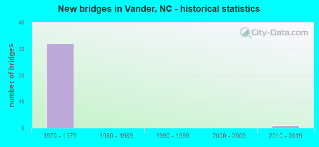
- New bridges - historical statistics
- 321970-1979
- 12010-2019


- Bridge Condition - Deck
- 11.1%Very good
- 66.7%Good
- 22.2%Fair

- Bridge Condition - Superstructure
- 11.1%Very good
- 77.8%Good
- 11.1%Fair

- Bridge Condition - Substructure
- 11.1%Very good
- 66.7%Good
- 11.1%Satisfactory
- 11.1%Fair
Find on map >> Show street view
Structure Number: 510011, Location: 0.2 MI.S. OF JCT.SR2000 (Lat: 35.021525, Lng: -78.805206), Route carried "on" structure: State highway 2008, Year Built: 2011, Status: Open, Structure Length: 2.95m (9.68ft), Average Daily Traffic: 1,700 (year 2016), Truck Traffic: 6%, Average Future Daily Traffic: 3,400 (year 2040), Design Load: HS 25 or greater, Features Intersected: LOCKS CREEK
Minimum Vertical Clearance: 30+ m (98+ ft), Kilometerpoint: 0.000, Lanes on structure: 2, Owner: State Highway Agency, Approaching Roadway Width: 10.9m (35.8ft), Material/Design: Prestressed concrete, Design/Construction: Slab, Number Of Spans In Main Unit: 3, Length of Maximum Span: 13.4m (44.0ft), Curb-To-Curb Width: 10.8m (35.4ft), Out-to-Out Width: 11.8m (38.7ft)
Condition: Deck: Very good, Superstructure: Very good, Substructure: Very good, Channel: Good, Operating Rating: 89.8 metric tons, Method Used To Determine Operating Rating: Load Factor (LF), Inventory Rating: 63.5 metric tons, Method Used To Determine Inventory Rating: Load Factor (LF), Structural Evaluation: Equal to present desirable criteria, Deck Geometry: Equal to present minimum criteria, Waterway Adequacy: Better than present minimum criteria, Approach Roadway Alignment: Equal to present desirable criteria, Designated Inspection Frequency: Every 24 months, Inspection Date: November 2020, Deck Structure Type: Concrete Precast Panels, Wearing Surface/Protective System: Wearing Surface: Bituminous
Find on map >> Show street view
Structure Number: 51011, Location: 0.2 MI.W.JCT.SR2010 (Lat: 35.016544, Lng: -78.787928), Route carried "on" structure: State highway 2012, Year Built: 1971, Status: Posted for load, Structure Length: 1.06m (3.48ft), Average Daily Traffic: 620 (year 2016), Truck Traffic: 6%, Average Future Daily Traffic: 1,240 (year 2040), Features Intersected: LOCKS CREEK
Minimum Vertical Clearance: 30+ m (98+ ft), Kilometerpoint: 0.000, Lanes on structure: 2, Owner: State Highway Agency, Approaching Roadway Width: 6.0m (19.7ft), Material/Design: Wood or Timber, Design/Construction: Stringer/Multi-beam, Number Of Spans In Main Unit: 2, Length of Maximum Span: 5.1m (16.7ft), Curb-To-Curb Width: 8.5m (27.9ft), Out-to-Out Width: 8.9m (29.2ft)
Condition: Deck: Fair, Superstructure: Fair, Substructure: Fair, Channel: Good, Operating Rating: 29.9 metric tons, Method Used To Determine Operating Rating: Allowable Stress (AS), Inventory Rating: 20.8 metric tons, Method Used To Determine Inventory Rating: Allowable Stress (AS), Structural Evaluation: Somewhat better than minimum adequacy, Deck Geometry: Somewhat better than minimum adequacy, Waterway Adequacy: Better than present minimum criteria, Approach Roadway Alignment: Equal to present desirable criteria, Bridge Posting: Required (Relationship of Operating Rating to Maximum Legal Load: 30.0 - 39.9% below), Designated Inspection Frequency: Every 24 months, Underwater Inspection Frequency: Every 60 months, Inspection Date: April 2021, Underwater Inspection Date: April 2021, Deck Structure Type: Concrete Cast-file-Place, Wearing Surface/Protective System: Wearing Surface: Monolithic Concrete
Find on map >> Show street view
Structure Number: 510135, Location: 0.4 MI.W.JCT.SR1835 (Lat: 35.042656, Lng: -78.803261), Route carried "on" structure: State highway 24, Year Built: 1979, Status: Open, Structure Length: 12.77m (41.90ft), Average Daily Traffic: 4,900 (year 2018), Truck Traffic: 14%, Average Future Daily Traffic: 9,800 (year 2040), Design Load: HS 20+Mod, Features Intersected: I95
Minimum Vertical Clearance: 30+ m (98+ ft), Kilometerpoint: 0.000, Lanes on structure: 2, Lanes under structure: 8, Base Highway Network: Yes (Inventory Route: 3, Subroute: 24), Owner: State Highway Agency, Approaching Roadway Width: 12.1m (39.7ft), Skew: 10 degrees, Material/Design: Steel continuous, Design/Construction: Stringer/Multi-beam, Number Of Spans In Main Unit: 2, Number Of Approach Spans: 2, Length of Maximum Span: 52.7m (172.9ft), Curb-To-Curb Width: 12.4m (40.7ft), Out-to-Out Width: 13.3m (43.6ft)
Condition: Deck: Good, Superstructure: Good, Substructure: Good, Operating Rating: 89.8 metric tons, Method Used To Determine Operating Rating: Load Factor (LF), Inventory Rating: 68.0 metric tons, Method Used To Determine Inventory Rating: Load Factor (LF), Structural Evaluation: Better than present minimum criteria, Deck Geometry: Better than present minimum criteria, Underclear: High priority of corrective action, Approach Roadway Alignment: Equal to present desirable criteria, Designated Inspection Frequency: Every 24 months, Inspection Date: Febuary 2022, Deck Structure Type: Concrete Cast-file-Place, Wearing Surface/Protective System: Wearing Surface: Monolithic Concrete
Find on map >> Show street view
Structure Number: 510136, Location: 0.4 MI.W.JCT.SR1835 (Lat: 35.042911, Lng: -78.803186), Route carried "on" structure: State highway 24, Year Built: 1979, Status: Open, Structure Length: 12.77m (41.90ft), Average Daily Traffic: 13,375 (year 2018), Truck Traffic: 14%, Average Future Daily Traffic: 26,750 (year 2040), Design Load: HS 20+Mod, Features Intersected: I95
Minimum Vertical Clearance: 30+ m (98+ ft), Kilometerpoint: 0.000, Lanes on structure: 2, Lanes under structure: 8, Base Highway Network: Yes (Inventory Route: 3, Subroute: 24), Owner: State Highway Agency, Approaching Roadway Width: 11.5m (37.7ft), Skew: 10 degrees, Material/Design: Steel continuous, Design/Construction: Stringer/Multi-beam, Number Of Spans In Main Unit: 4, Number Of Approach Spans: 2, Length of Maximum Span: 52.7m (172.9ft), Curb-To-Curb Width: 12.4m (40.7ft), Out-to-Out Width: 13.3m (43.6ft)
Condition: Deck: Good, Superstructure: Good, Substructure: Good, Operating Rating: 89.8 metric tons, Method Used To Determine Operating Rating: Load Factor (LF), Inventory Rating: 68.0 metric tons, Method Used To Determine Inventory Rating: Load Factor (LF), Structural Evaluation: Better than present minimum criteria, Deck Geometry: Better than present minimum criteria, Underclear: High priority of corrective action, Approach Roadway Alignment: Equal to present desirable criteria, Designated Inspection Frequency: Every 24 months, Inspection Date: Febuary 2022, Deck Structure Type: Concrete Cast-file-Place, Wearing Surface/Protective System: Wearing Surface: Monolithic Concrete
Find on map >> Show street view
Structure Number: 510137, Location: 0.1 MI.N. JCT.SR1006 (Lat: 35.041492, Lng: -78.773447), Route carried "on" structure: State highway 1831, Year Built: 1979, Status: Open, Structure Length: 6.98m (22.90ft), Average Daily Traffic: 4,500 (year 2018), Truck Traffic: 6%, Average Future Daily Traffic: 9,000 (year 2040), Design Load: HS 15, Features Intersected: NC24
Minimum Vertical Clearance: 30+ m (98+ ft), Kilometerpoint: 0.000, Lanes on structure: 2, Lanes under structure: 4, Owner: State Highway Agency, Approaching Roadway Width: 10.9m (35.8ft), Material/Design: Steel, Design/Construction: Stringer/Multi-beam, Number Of Spans In Main Unit: 4, Length of Maximum Span: 27.1m (88.9ft), Curb-To-Curb Width: 10.9m (35.8ft), Out-to-Out Width: 11.8m (38.7ft)
Condition: Deck: Good, Superstructure: Good, Substructure: Good, Operating Rating: 87.9 metric tons, Method Used To Determine Operating Rating: Load Factor (LF), Inventory Rating: 52.6 metric tons, Method Used To Determine Inventory Rating: Load Factor (LF), Structural Evaluation: Better than present minimum criteria, Deck Geometry: Somewhat better than minimum adequacy, Underclear: Equal to present minimum criteria, Approach Roadway Alignment: Equal to present desirable criteria, Designated Inspection Frequency: Every 24 months, Inspection Date: Febuary 2022, Deck Structure Type: Concrete Cast-file-Place, Wearing Surface/Protective System: Wearing Surface: Monolithic Concrete
Find on map >> Show street view
Structure Number: 510138, Location: 0.4 MI.W.JCT.SR1835 (Lat: 35.042486, Lng: -78.803308), Route carried "on" structure: Ramp Interstate 95, Year Built: 1979, Status: Open, Structure Length: 12.77m (41.90ft), Average Daily Traffic: 4,900 (year 2018), Truck Traffic: 23%, Average Future Daily Traffic: 9,800 (year 2040), Design Load: HS 20+Mod, Features Intersected: I95
Minimum Vertical Clearance: 30+ m (98+ ft), Kilometerpoint: 15.727, Lanes on structure: 2, Lanes under structure: 8, Owner: State Highway Agency, Approaching Roadway Width: 11.8m (38.7ft), Skew: 10 degrees, Material/Design: Steel continuous, Design/Construction: Stringer/Multi-beam, Number Of Spans In Main Unit: 2, Number Of Approach Spans: 2, Length of Maximum Span: 52.7m (172.9ft), Curb-To-Curb Width: 12.4m (40.7ft), Out-to-Out Width: 13.3m (43.6ft)
Condition: Deck: Good, Superstructure: Good, Substructure: Satisfactory, Operating Rating: 89.8 metric tons, Method Used To Determine Operating Rating: Load Factor (LF), Inventory Rating: 64.4 metric tons, Method Used To Determine Inventory Rating: Load Factor (LF), Structural Evaluation: Equal to present minimum criteria, Deck Geometry: Superior to present desirable criteria, Underclear: High priority of corrective action, Approach Roadway Alignment: Equal to present desirable criteria, Designated Inspection Frequency: Every 24 months, Inspection Date: Febuary 2022, Deck Structure Type: Concrete Cast-file-Place, Wearing Surface/Protective System: Wearing Surface: Latex Concrete
Find on map >> Show street view
Structure Number: 510139, Location: 0.4 MI. W. JCT. SR1835 (Lat: 35.043086, Lng: -78.803131), Route carried "on" structure: Ramp Interstate 95, Year Built: 1979, Status: Open, Structure Length: 12.77m (41.90ft), Average Daily Traffic: 2,450 (year 2018), Truck Traffic: 23%, Average Future Daily Traffic: 4,900 (year 2040), Design Load: HS 20+Mod, Features Intersected: I95
Minimum Vertical Clearance: 30+ m (98+ ft), Kilometerpoint: 0.000, Lanes on structure: 2, Lanes under structure: 8, Owner: State Highway Agency, Approaching Roadway Width: 11.5m (37.7ft), Skew: 10 degrees, Material/Design: Steel continuous, Design/Construction: Stringer/Multi-beam, Number Of Spans In Main Unit: 4, Number Of Approach Spans: 2, Length of Maximum Span: 52.7m (172.9ft), Curb-To-Curb Width: 12.4m (40.7ft), Out-to-Out Width: 13.3m (43.6ft)
Condition: Deck: Good, Superstructure: Good, Substructure: Good, Operating Rating: 89.8 metric tons, Method Used To Determine Operating Rating: Load Factor (LF), Inventory Rating: 68.9 metric tons, Method Used To Determine Inventory Rating: Load Factor (LF), Structural Evaluation: Better than present minimum criteria, Deck Geometry: Superior to present desirable criteria, Underclear: High priority of corrective action, Approach Roadway Alignment: Equal to present desirable criteria, Designated Inspection Frequency: Every 24 months, Inspection Date: Febuary 2022, Deck Structure Type: Concrete Cast-file-Place, Wearing Surface/Protective System: Wearing Surface: Monolithic Concrete
Find on map >> Show street view
Structure Number: 51014, Location: 150' S.JCT SR1836 (Lat: 35.041808, Lng: -78.795700), Route carried "on" structure: State highway 1835, Year Built: 1979, Status: Open, Structure Length: 10.54m (34.58ft), Average Daily Traffic: 1,700 (year 2016), Truck Traffic: 7%, Average Future Daily Traffic: 3,400 (year 2040), Design Load: HS 15, Features Intersected: NC24
Minimum Vertical Clearance: 30+ m (98+ ft), Kilometerpoint: 0.000, Lanes on structure: 2, Lanes under structure: 7, Owner: State Highway Agency, Approaching Roadway Width: 7.9m (25.9ft), Material/Design: Steel, Design/Construction: Stringer/Multi-beam, Number Of Spans In Main Unit: 4, Length of Maximum Span: 45.4m (149.0ft), Curb-To-Curb Width: 12.1m (39.7ft), Out-to-Out Width: 12.8m (42.0ft)
Condition: Deck: Good, Superstructure: Good, Substructure: Good, Operating Rating: 89.8 metric tons, Method Used To Determine Operating Rating: Load Factor (LF), Inventory Rating: 61.6 metric tons, Method Used To Determine Inventory Rating: Load Factor (LF), Structural Evaluation: Better than present minimum criteria, Deck Geometry: Equal to present minimum criteria, Underclear: Somewhat better than minimum adequacy, Approach Roadway Alignment: Equal to present desirable criteria, Designated Inspection Frequency: Every 24 months, Inspection Date: Febuary 2022, Deck Structure Type: Concrete Cast-file-Place, Wearing Surface/Protective System: Wearing Surface: Monolithic Concrete
Find on map >> Show street view
Structure Number: 510146, Location: 0.1 MI. E. OF JCT. SR1834 (Lat: 35.053200, Lng: -78.798825), Route carried "on" structure: State highway 1835, Year Built: 1979, Status: Open, Structure Length: 11.36m (37.27ft), Average Daily Traffic: 1,700 (year 2016), Truck Traffic: 8%, Average Future Daily Traffic: 3,400 (year 2040), Design Load: HS 15, Features Intersected: I95
Minimum Vertical Clearance: 30+ m (98+ ft), Kilometerpoint: 0.000, Lanes on structure: 2, Lanes under structure: 5, Owner: State Highway Agency, Approaching Roadway Width: 7.9m (25.9ft), Skew: 4 degrees, Material/Design: Steel, Design/Construction: Stringer/Multi-beam, Number Of Spans In Main Unit: 4, Length of Maximum Span: 46.9m (153.9ft), Curb-To-Curb Width: 12.0m (39.4ft), Out-to-Out Width: 12.8m (42.0ft)
Condition: Deck: Fair, Superstructure: Good, Substructure: Good, Operating Rating: 89.8 metric tons, Method Used To Determine Operating Rating: Load Factor (LF), Inventory Rating: 55.3 metric tons, Method Used To Determine Inventory Rating: Load Factor (LF), Structural Evaluation: Better than present minimum criteria, Deck Geometry: Equal to present minimum criteria, Underclear: Equal to present minimum criteria, Approach Roadway Alignment: Equal to present desirable criteria, Designated Inspection Frequency: Every 24 months, Inspection Date: December 2021, Deck Structure Type: Concrete Cast-file-Place, Wearing Surface/Protective System: Wearing Surface: Monolithic Concrete
Find on map >> Show street view
Structure Number: 510135, Location: 0.4 MI.W.JCT.SR1835 (Lat: 35.042656, Lng: -78.803261), Route carried "under" structure: Ramp State highway 24, Year Built: 1979, Structure Length: 0. m, Average Daily Traffic: 3,266 (year 2018), Truck Traffic: 14%, Features Intersected: NC24E
Minimum Vertical Clearance: 5.42m (17.78ft), Kilometerpoint: 15.727, Lanes on structure: 2, Lanes under structure: 2, Material/Design: Steel continuous, Design/Construction: Stringer/Multi-beam, Length of Maximum Span: 52.7m (172.9ft)
Find on map >> Show street view
Structure Number: 510135, Location: 0.4 MI.W.JCT.SR1835 (Lat: 35.042656, Lng: -78.803261), Route carried "under" structure: Interstate 95, Year Built: 1979, Structure Length: 0. m, Average Daily Traffic: 26,750 (year 2018), Truck Traffic: 16%, Features Intersected: NC24E
Minimum Vertical Clearance: 5.21m (17.09ft), Kilometerpoint: 15.727, Lanes on structure: 2, Lanes under structure: 2, Material/Design: Steel continuous, Design/Construction: Stringer/Multi-beam, Length of Maximum Span: 52.7m (172.9ft)
Find on map >> Show street view
Structure Number: 510135, Location: 0.4 MI.W.JCT.SR1835 (Lat: 35.042656, Lng: -78.803261), Route carried "under" structure: Interstate 95, Year Built: 1979, Structure Length: 0. m, Average Daily Traffic: 26,750 (year 2018), Truck Traffic: 16%, Features Intersected: NC24E
Minimum Vertical Clearance: 5.33m (17.49ft), Kilometerpoint: 15.727, Lanes on structure: 2, Lanes under structure: 2, Material/Design: Steel continuous, Design/Construction: Stringer/Multi-beam, Length of Maximum Span: 52.7m (172.9ft)
Find on map >> Show street view
Structure Number: 510135, Location: 0.4 MI.W.JCT.SR1835 (Lat: 35.042656, Lng: -78.803261), Route carried "under" structure: Ramp State highway 24, Year Built: 1979, Structure Length: 0. m, Average Daily Traffic: 3,266 (year 2018), Truck Traffic: 14%, Features Intersected: NC24E
Minimum Vertical Clearance: 5.27m (17.29ft), Kilometerpoint: 15.727, Lanes on structure: 2, Lanes under structure: 2, Material/Design: Steel continuous, Design/Construction: Stringer/Multi-beam, Length of Maximum Span: 52.7m (172.9ft)
Find on map >> Show street view
Structure Number: 510136, Location: 0.4 MI.W.JCT.SR1835 (Lat: 35.042911, Lng: -78.803186), Route carried "under" structure: Ramp State highway 24, Year Built: 1979, Structure Length: 0. m, Average Daily Traffic: 4,900 (year 2018), Truck Traffic: 14%, Features Intersected: NC24 WBL
Minimum Vertical Clearance: 5.41m (17.75ft), Kilometerpoint: 15.727, Lanes on structure: 2, Lanes under structure: 2, Material/Design: Steel continuous, Design/Construction: Stringer/Multi-beam, Length of Maximum Span: 52.7m (172.9ft)
Find on map >> Show street view
Structure Number: 510136, Location: 0.4 MI.W.JCT.SR1835 (Lat: 35.042911, Lng: -78.803186), Route carried "under" structure: Interstate 95, Year Built: 1979, Structure Length: 0. m, Average Daily Traffic: 14,125 (year 2018), Truck Traffic: 23%, Features Intersected: NC24 WBL
Minimum Vertical Clearance: 5.30m (17.39ft), Kilometerpoint: 15.727, Lanes on structure: 2, Lanes under structure: 2, Material/Design: Steel continuous, Design/Construction: Stringer/Multi-beam, Length of Maximum Span: 52.7m (172.9ft)
Find on map >> Show street view
Structure Number: 510136, Location: 0.4 MI.W.JCT.SR1835 (Lat: 35.042911, Lng: -78.803186), Route carried "under" structure: Interstate 95, Year Built: 1979, Structure Length: 0. m, Average Daily Traffic: 13,375 (year 2018), Truck Traffic: 23%, Features Intersected: NC24 WBL
Minimum Vertical Clearance: 5.27m (17.29ft), Kilometerpoint: 15.727, Lanes on structure: 2, Lanes under structure: 2, Material/Design: Steel continuous, Design/Construction: Stringer/Multi-beam, Length of Maximum Span: 52.7m (172.9ft)
Find on map >> Show street view
Structure Number: 510136, Location: 0.4 MI.W.JCT.SR1835 (Lat: 35.042911, Lng: -78.803186), Route carried "under" structure: Ramp State highway 24, Year Built: 1979, Structure Length: 0. m, Average Daily Traffic: 4,900 (year 2018), Truck Traffic: 14%, Features Intersected: NC24 WBL
Minimum Vertical Clearance: 5.53m (18.14ft), Kilometerpoint: 15.727, Lanes on structure: 2, Lanes under structure: 2, Material/Design: Steel continuous, Design/Construction: Stringer/Multi-beam, Length of Maximum Span: 52.7m (172.9ft)
Find on map >> Show street view
Structure Number: 510137, Location: 0.1 MI.N. JCT.SR1006 (Lat: 35.041492, Lng: -78.773447), Route carried "under" structure: State highway 24, Year Built: 1979, Structure Length: 0. m, Average Daily Traffic: 6,000 (year 2018), Truck Traffic: 14%, Features Intersected: SR1831
Minimum Vertical Clearance: 5.05m (16.57ft), Kilometerpoint: 0.000, Lanes on structure: 2, Lanes under structure: 2, Material/Design: Steel, Design/Construction: Stringer/Multi-beam, Length of Maximum Span: 27.1m (88.9ft)
Find on map >> Show street view
Structure Number: 510137, Location: 0.1 MI.N. JCT.SR1006 (Lat: 35.041492, Lng: -78.773447), Route carried "under" structure: State highway 24, Year Built: 1979, Structure Length: 0. m, Average Daily Traffic: 6,000 (year 2018), Truck Traffic: 14%, Features Intersected: SR1831
Minimum Vertical Clearance: 5.35m (17.55ft), Kilometerpoint: 0.000, Lanes on structure: 2, Lanes under structure: 2, Material/Design: Steel, Design/Construction: Stringer/Multi-beam, Length of Maximum Span: 27.1m (88.9ft)
Find on map >> Show street view
Structure Number: 510138, Location: 0.4 MI.W.JCT.SR1835 (Lat: 35.042486, Lng: -78.803308), Route carried "under" structure: Ramp State highway 24, Year Built: 1979, Structure Length: 0. m, Average Daily Traffic: 19,000 (year 2013), Truck Traffic: 16%, Features Intersected: I95NRAMP,NC24E.CON
Minimum Vertical Clearance: 5.28m (17.32ft), Kilometerpoint: 15.727, Lanes on structure: 2, Lanes under structure: 2, Material/Design: Steel continuous, Design/Construction: Stringer/Multi-beam, Length of Maximum Span: 52.7m (172.9ft)
Find on map >> Show street view
Structure Number: 510138, Location: 0.4 MI.W.JCT.SR1835 (Lat: 35.042486, Lng: -78.803308), Route carried "under" structure: Ramp State highway 24, Year Built: 1979, Structure Length: 0. m, Average Daily Traffic: 26,750 (year 2018), Truck Traffic: 23%, Features Intersected: I95NRAMP,NC24E.CON
Minimum Vertical Clearance: 5.18m (16.99ft), Kilometerpoint: 15.727, Lanes on structure: 2, Lanes under structure: 2, Material/Design: Steel continuous, Design/Construction: Stringer/Multi-beam, Length of Maximum Span: 52.7m (172.9ft)
Find on map >> Show street view
Structure Number: 510138, Location: 0.4 MI.W.JCT.SR1835 (Lat: 35.042486, Lng: -78.803308), Route carried "under" structure: Interstate 95, Year Built: 1979, Structure Length: 0. m, Average Daily Traffic: 26,750 (year 2018), Truck Traffic: 23%, Features Intersected: I95NRAMP,NC24E.CON
Minimum Vertical Clearance: 5.18m (16.99ft), Kilometerpoint: 15.727, Lanes on structure: 2, Lanes under structure: 2, Material/Design: Steel continuous, Design/Construction: Stringer/Multi-beam, Length of Maximum Span: 52.7m (172.9ft)
Find on map >> Show street view
Structure Number: 510138, Location: 0.4 MI.W.JCT.SR1835 (Lat: 35.042486, Lng: -78.803308), Route carried "under" structure: Interstate 95, Year Built: 1979, Structure Length: 0. m, Average Daily Traffic: 26,750 (year 2018), Truck Traffic: 23%, Features Intersected: I95NRAMP,NC24E.CON
Minimum Vertical Clearance: 5.15m (16.90ft), Kilometerpoint: 15.727, Lanes on structure: 2, Lanes under structure: 2, Material/Design: Steel continuous, Design/Construction: Stringer/Multi-beam, Length of Maximum Span: 52.7m (172.9ft)
Find on map >> Show street view
Structure Number: 510139, Location: 0.4 MI. W. JCT. SR1835 (Lat: 35.043086, Lng: -78.803131), Route carried "under" structure: Interstate 95, Year Built: 1979, Structure Length: 0. m, Average Daily Traffic: 13,375 (year 2018), Truck Traffic: 23%, Features Intersected: I95RAMP,NC24W.CON
Minimum Vertical Clearance: 5.23m (17.16ft), Kilometerpoint: 15.727, Lanes on structure: 2, Lanes under structure: 2, Material/Design: Steel continuous, Design/Construction: Stringer/Multi-beam, Length of Maximum Span: 52.7m (172.9ft)
Find on map >> Show street view
Structure Number: 510139, Location: 0.4 MI. W. JCT. SR1835 (Lat: 35.043086, Lng: -78.803131), Route carried "under" structure: Ramp Interstate 95, Year Built: 1979, Structure Length: 0. m, Average Daily Traffic: 6,688 (year 2018), Truck Traffic: 23%, Features Intersected: I95RAMP,NC24W.CON
Minimum Vertical Clearance: 5.39m (17.68ft), Kilometerpoint: 15.727, Lanes on structure: 2, Lanes under structure: 2, Material/Design: Steel continuous, Design/Construction: Stringer/Multi-beam, Length of Maximum Span: 52.7m (172.9ft)
Find on map >> Show street view
Structure Number: 510139, Location: 0.4 MI. W. JCT. SR1835 (Lat: 35.043086, Lng: -78.803131), Route carried "under" structure: Interstate 95, Year Built: 1979, Structure Length: 0. m, Average Daily Traffic: 13,375 (year 2018), Truck Traffic: 23%, Features Intersected: I95RAMP,NC24W.CON
Minimum Vertical Clearance: 5.15m (16.90ft), Kilometerpoint: 15.727, Lanes on structure: 2, Lanes under structure: 2, Material/Design: Steel continuous, Design/Construction: Stringer/Multi-beam, Length of Maximum Span: 52.7m (172.9ft)
Find on map >> Show street view
Structure Number: 510139, Location: 0.4 MI. W. JCT. SR1835 (Lat: 35.043086, Lng: -78.803131), Route carried "under" structure: Ramp Interstate 95, Year Built: 1979, Structure Length: 0. m, Average Daily Traffic: 6,688 (year 2018), Truck Traffic: 23%, Features Intersected: I95RAMP,NC24W.CON
Minimum Vertical Clearance: 5.20m (17.06ft), Kilometerpoint: 15.727, Lanes on structure: 2, Lanes under structure: 2, Material/Design: Steel continuous, Design/Construction: Stringer/Multi-beam, Length of Maximum Span: 52.7m (172.9ft)
Find on map >> Show street view
Structure Number: 51014, Location: 150' S.JCT SR1836 (Lat: 35.041808, Lng: -78.795700), Route carried "under" structure: State highway 24, Year Built: 1979, Structure Length: 0. m, Average Daily Traffic: 6,000 (year 2018), Truck Traffic: 14%, Features Intersected: SR1835
Minimum Vertical Clearance: 5.13m (16.83ft), Kilometerpoint: 0.000, Lanes on structure: 2, Lanes under structure: 2, Material/Design: Steel, Design/Construction: Stringer/Multi-beam, Length of Maximum Span: 45.4m (149.0ft)
Find on map >> Show street view
Structure Number: 51014, Location: 150' S.JCT SR1836 (Lat: 35.041808, Lng: -78.795700), Route carried "under" structure: Ramp State highway 24, Year Built: 1979, Structure Length: 0. m, Average Daily Traffic: 6,000 (year 2018), Truck Traffic: 14%, Features Intersected: SR1835
Minimum Vertical Clearance: 5.25m (17.22ft), Kilometerpoint: 0.000, Lanes on structure: 2, Lanes under structure: 2, Material/Design: Steel, Design/Construction: Stringer/Multi-beam, Length of Maximum Span: 45.4m (149.0ft)
Find on map >> Show street view
Structure Number: 51014, Location: 150' S.JCT SR1836 (Lat: 35.041808, Lng: -78.795700), Route carried "under" structure: Ramp State highway 24, Year Built: 1979, Structure Length: 0. m, Average Daily Traffic: 3,000 (year 2012), Truck Traffic: 14%, Features Intersected: SR1835
Minimum Vertical Clearance: 5.35m (17.55ft), Kilometerpoint: 0.000, Lanes on structure: 2, Lanes under structure: 1, Material/Design: Steel, Design/Construction: Stringer/Multi-beam, Length of Maximum Span: 45.4m (149.0ft)
Find on map >> Show street view
Structure Number: 51014, Location: 150' S.JCT SR1836 (Lat: 35.041808, Lng: -78.795700), Route carried "under" structure: State highway 24, Year Built: 1979, Structure Length: 0. m, Average Daily Traffic: 6,000 (year 2018), Truck Traffic: 14%, Features Intersected: SR1835
Minimum Vertical Clearance: 5.20m (17.06ft), Kilometerpoint: 0.000, Lanes on structure: 2, Lanes under structure: 2, Material/Design: Steel, Design/Construction: Stringer/Multi-beam, Length of Maximum Span: 45.4m (149.0ft)
Find on map >> Show street view
Structure Number: 510146, Location: 0.1 MI. E. OF JCT. SR1834 (Lat: 35.053200, Lng: -78.798825), Route carried "under" structure: Interstate 95, Year Built: 1979, Structure Length: 0. m, Average Daily Traffic: 23,750 (year 2019), Truck Traffic: 23%, Features Intersected: SR1835
Minimum Vertical Clearance: 5.58m (18.31ft), Kilometerpoint: 15.941, Lanes on structure: 2, Lanes under structure: 2, Material/Design: Steel, Design/Construction: Stringer/Multi-beam, Length of Maximum Span: 46.9m (153.9ft)
Find on map >> Show street view
Structure Number: 510146, Location: 0.1 MI. E. OF JCT. SR1834 (Lat: 35.053200, Lng: -78.798825), Route carried "under" structure: Interstate 95, Year Built: 1979, Structure Length: 0. m, Average Daily Traffic: 23,750 (year 2019), Truck Traffic: 23%, Features Intersected: SR1835
Minimum Vertical Clearance: 5.63m (18.47ft), Kilometerpoint: 1585.893, Lanes on structure: 2, Lanes under structure: 3, Material/Design: Steel, Design/Construction: Stringer/Multi-beam, Length of Maximum Span: 46.9m (153.9ft)