Bridge Statistics for Vega, Texas (TX)
Condition, Traffic, Stress, Structural Evaluation, Project Costs
- National Bridge Inventory (NBI) Statistics
- 17Number of bridges
- 210ft / 63.8mTotal length
- $275,000Total costs
- 96,259Total average daily traffic
- 46,927Total average daily truck traffic
- National Bridge Inventory (NBI) Registered Bridges for Vega
- No street view available for this location
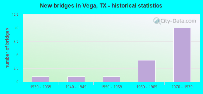
- New bridges - historical statistics
- 11930-1939
- 11940-1949
- 11950-1959
- 41960-1969
- 101970-1979

- Reconstructed bridges - Historical Statistics
- 21970-1979
- 11980-1989


- Bridge Condition - Deck
- 16.7%Very good
- 16.7%Good
- 66.7%Satisfactory

- Bridge Condition - Superstructure
- 33.3%Good
- 66.7%Satisfactory

- Bridge Condition - Substructure
- 16.7%Very good
- 66.7%Satisfactory
- 16.7%Fair

- Bridge Condition - Channel
- 20.0%Very good
- 60.0%Good
- 20.0%Satisfactory

- Bridge Condition - Culverts
- 80.0%Good
- 20.0%Satisfactory
Find on map >> Show street view
Structure Number: 41800009003016, Location: 0.27 MI E OF FM 3319 (Lat: 35.254511, Lng: -102.481325), Route carried "on" structure: Interstate 40, Year Built: 1937, Year Reconstructed: 1980, Status: Open, Structure Length: 1.01m (3.31ft), Average Daily Traffic: 13,595 (year 2020), Truck Traffic: 49%, Average Future Daily Traffic: 15,880 (year 2033), Design Load: H 15, Features Intersected: Drain
Minimum Vertical Clearance: 30+ m (98+ ft), Kilometerpoint: 26.371, Lanes on structure: 8, Owner: State Highway Agency, Approaching Roadway Width: 37.8m (124.0ft), Material/Design: Concrete, Design/Construction: Culvert, Number Of Spans In Main Unit: 5, Length of Maximum Span: 1.8m (5.9ft)
Condition: Channel: Good, Culverts: Good, Operating Rating: 39.9 metric tons, Method Used To Determine Operating Rating: Load Factor (LF), Inventory Rating: 23.6 metric tons, Method Used To Determine Inventory Rating: Load Factor (LF), Structural Evaluation: Somewhat better than minimum adequacy, Waterway Adequacy: Equal to present minimum criteria, Approach Roadway Alignment: Equal to present desirable criteria, Designated Inspection Frequency: Every 24 months, Inspection Date: September 2021
Find on map >> Show street view
Structure Number: 4180000900305, Location: 0.3 Mi W of FM 3319 (Lat: 35.255850, Lng: -102.488497), Route carried "on" structure: Interstate 40, Year Built: 1969, Status: Open, Structure Length: 0.99m (3.25ft), Average Daily Traffic: 10,070 (year 2013), Truck Traffic: 49%, Average Future Daily Traffic: 14,100 (year 2033), Design Load: HS 20, Features Intersected: Drain
Minimum Vertical Clearance: 30+ m (98+ ft), Kilometerpoint: 25.827, Lanes on structure: 6, Owner: State Highway Agency, Approaching Roadway Width: 30.5m (100.1ft), Skew: 29 degrees, Material/Design: Concrete, Design/Construction: Culvert, Number Of Spans In Main Unit: 4, Length of Maximum Span: 1.5m (4.9ft)
Condition: Channel: Very good, Culverts: Good, Operating Rating: 39.9 metric tons, Method Used To Determine Operating Rating: Load Factor (LF), Inventory Rating: 23.6 metric tons, Method Used To Determine Inventory Rating: Load Factor (LF), Structural Evaluation: Somewhat better than minimum adequacy, Waterway Adequacy: Superior to present desirable criteria, Approach Roadway Alignment: Equal to present desirable criteria, Designated Inspection Frequency: Every 24 months, Inspection Date: September 2021
Find on map >> Show street view
Structure Number: 41800009003051, Location: 0.05 Mi E of FM 3319 (Lat: 35.255797, Lng: -102.486128), Route carried "on" structure: ServiceCounty highway 40, Year Built: 1969, Status: Open, Structure Length: 0.67m (2.20ft), Average Daily Traffic: 260 (year 2013), Truck Traffic: 35%, Average Future Daily Traffic: 360 (year 2033), Design Load: HS 20, Features Intersected: Drain
Minimum Vertical Clearance: 30+ m (98+ ft), Kilometerpoint: 26.030, Lanes on structure: 2, Owner: State Highway Agency, Approaching Roadway Width: 7.3m (24.0ft), Material/Design: Concrete, Design/Construction: Culvert, Number Of Spans In Main Unit: 4, Length of Maximum Span: 1.5m (4.9ft), Curb-To-Curb Width: 8.5m (27.9ft), Out-to-Out Width: 16.1m (52.8ft)
Condition: Channel: Good, Culverts: Good, Operating Rating: 39.9 metric tons, Method Used To Determine Operating Rating: Load Factor (LF), Inventory Rating: 23.6 metric tons, Method Used To Determine Inventory Rating: Load Factor (LF), Structural Evaluation: Equal to present minimum criteria, Deck Geometry: Equal to present minimum criteria, Waterway Adequacy: Equal to present minimum criteria, Approach Roadway Alignment: Equal to present desirable criteria, Designated Inspection Frequency: Every 24 months, Inspection Date: September 2021, Deck Structure Type: Concrete Cast-file-Place, Wearing Surface/Protective System: Wearing Surface: Bituminous
Find on map >> Show street view
Structure Number: 41800009003052, Location: 3.65 MI W OF US 385 (Lat: 35.255139, Lng: -102.487533), Route carried "on" structure: State highway 3319, Year Built: 1969, Status: Posted for load, Structure Length: 15.09m (49.51ft), Average Daily Traffic: 40 (year 2013), Truck Traffic: 40%, Average Future Daily Traffic: 50 (year 2033), Design Load: H 15, Features Intersected: IH 40
Minimum Vertical Clearance: 30+ m (98+ ft), Kilometerpoint: 16.093, Lanes on structure: 2, Lanes under structure: 8, Owner: State Highway Agency, Approaching Roadway Width: 7.3m (24.0ft), Skew: 9 degrees, Material/Design: Steel continuous, Design/Construction: Stringer/Multi-beam, Number Of Spans In Main Unit: 4, Number Of Approach Spans: 4, Length of Maximum Span: 22.9m (75.1ft), Curb-To-Curb Width: 8.0m (26.2ft), Out-to-Out Width: 8.6m (28.2ft)
Condition: Deck: Satisfactory, Superstructure: Satisfactory, Substructure: Satisfactory, Operating Rating: 36.3 metric tons, Method Used To Determine Operating Rating: Load Factor (LF), Inventory Rating: 21.8 metric tons, Method Used To Determine Inventory Rating: Load Factor (LF), Structural Evaluation: Equal to present minimum criteria, Deck Geometry: Equal to present minimum criteria, Underclear: Better than present minimum criteria, Approach Roadway Alignment: Equal to present desirable criteria, Bridge Posting: Required (Relationship of Operating Rating to Maximum Legal Load: 0.1 - 9.9% below), Designated Inspection Frequency: Every 24 months, Inspection Date: September 2021, Deck Structure Type: Concrete Cast-file-Place, Wearing Surface/Protective System: Wearing Surface: Bituminous
Find on map >> Show street view
Structure Number: 41800009003056, Location: 1.2 Mi W of US 385 (Lat: 35.246994, Lng: -102.448217), Route carried "on" structure: Business State highway 40, Year Built: 1973, Status: Open, Structure Length: 8.38m (27.49ft), Average Daily Traffic: 500 (year 2013), Truck Traffic: 8%, Average Future Daily Traffic: 700 (year 2033), Design Load: HS 20, Features Intersected: IH 40
Minimum Vertical Clearance: 30+ m (98+ ft), Kilometerpoint: 1.157, Lanes on structure: 2, Lanes under structure: 4, Owner: State Highway Agency, Approaching Roadway Width: 11.6m (38.1ft), Skew: 3 degrees, Material/Design: Prestressed concrete, Design/Construction: Stringer/Multi-beam, Number Of Spans In Main Unit: 2, Number Of Approach Spans: 2, Length of Maximum Span: 30.5m (100.1ft), Curb-To-Curb Width: 11.9m (39.0ft), Out-to-Out Width: 12.9m (42.3ft)
Condition: Deck: Satisfactory, Superstructure: Satisfactory, Substructure: Fair, Operating Rating: 44.4 metric tons, Method Used To Determine Operating Rating: Assigned ratings based on Allowable Stress Design (ASD) reported in metric tons, Inventory Rating: 32.7 metric tons, Method Used To Determine Inventory Rating: Assigned ratings based on Allowable Stress Design (ASD) reported in metric tons, Structural Evaluation: Somewhat better than minimum adequacy, Deck Geometry: Better than present minimum criteria, Underclear: Somewhat better than minimum adequacy, Approach Roadway Alignment: Equal to present desirable criteria, Length Of Structure Improvement: 8.38m (27.49ft), Designated Inspection Frequency: Every 24 months, Inspection Date: September 2021, Bridge Improvement Cost: $220,000, Roadway Improvement Cost: $55,000, Total Project Cost: $275,000, Deck Structure Type: Concrete Cast-file-Place
Find on map >> Show street view
Structure Number: 41800009004057, Location: JCT US 385 in Vega (Lat: 35.237044, Lng: -102.427906), Route carried "on" structure: Interstate 40, Year Built: 1973, Status: Open, Structure Length: 5.49m (18.01ft), Average Daily Traffic: 6,944 (year 2019), Truck Traffic: 49%, Average Future Daily Traffic: 7,460 (year 2033), Design Load: HS 20, Features Intersected: US 385
Minimum Vertical Clearance: 30+ m (98+ ft), Kilometerpoint: 54.900, Lanes on structure: 2, Lanes under structure: 2, Owner: State Highway Agency, Approaching Roadway Width: 12.2m (40.0ft), Skew: 2 degrees, Material/Design: Prestressed concrete, Design/Construction: Stringer/Multi-beam, Number Of Spans In Main Unit: 1, Number Of Approach Spans: 2, Length of Maximum Span: 22.9m (75.1ft), Curb-To-Curb Width: 12.4m (40.7ft), Out-to-Out Width: 12.9m (42.3ft)
Condition: Deck: Satisfactory, Superstructure: Satisfactory, Substructure: Satisfactory, Operating Rating: 44.4 metric tons, Method Used To Determine Operating Rating: Assigned ratings based on Allowable Stress Design (ASD) reported in metric tons, Inventory Rating: 32.7 metric tons, Method Used To Determine Inventory Rating: Assigned ratings based on Allowable Stress Design (ASD) reported in metric tons, Structural Evaluation: Equal to present minimum criteria, Deck Geometry: Better than present minimum criteria, Underclear: Meets minimum limits, Approach Roadway Alignment: Equal to present desirable criteria, Designated Inspection Frequency: Every 24 months, Inspection Date: September 2021, Deck Structure Type: Concrete Cast-file-Place, Wearing Surface/Protective System: Wearing Surface: Bituminous
Find on map >> Show street view
Structure Number: 41800009004058, Location: JCT US 385 in Vega (Lat: 35.236853, Lng: -102.428383), Route carried "on" structure: Interstate 40, Year Built: 1973, Status: Open, Structure Length: 5.49m (18.01ft), Average Daily Traffic: 5,330 (year 2013), Truck Traffic: 49%, Average Future Daily Traffic: 7,460 (year 2033), Design Load: HS 20, Features Intersected: US 385
Minimum Vertical Clearance: 30+ m (98+ ft), Kilometerpoint: 54.875, Lanes on structure: 2, Lanes under structure: 2, Owner: State Highway Agency, Approaching Roadway Width: 12.2m (40.0ft), Skew: 2 degrees, Material/Design: Prestressed concrete, Design/Construction: Stringer/Multi-beam, Number Of Spans In Main Unit: 1, Number Of Approach Spans: 2, Length of Maximum Span: 22.9m (75.1ft), Curb-To-Curb Width: 12.5m (41.0ft), Out-to-Out Width: 12.9m (42.3ft)
Condition: Deck: Satisfactory, Superstructure: Satisfactory, Substructure: Satisfactory, Operating Rating: 44.4 metric tons, Method Used To Determine Operating Rating: Assigned ratings based on Allowable Stress Design (ASD) reported in metric tons, Inventory Rating: 32.7 metric tons, Method Used To Determine Inventory Rating: Assigned ratings based on Allowable Stress Design (ASD) reported in metric tons, Structural Evaluation: Equal to present minimum criteria, Deck Geometry: Better than present minimum criteria, Underclear: Meets minimum limits, Approach Roadway Alignment: Equal to present desirable criteria, Designated Inspection Frequency: Every 24 months, Inspection Date: September 2021, Deck Structure Type: Concrete Cast-file-Place, Wearing Surface/Protective System: Wearing Surface: Integral Concrete
Find on map >> Show street view
Structure Number: 41800009004059, Location: 1.2 Mi E of US 385 (Lat: 35.238683, Lng: -102.406044), Route carried "on" structure: Business State highway 40, Year Built: 1973, Status: Open, Structure Length: 9.54m (31.30ft), Average Daily Traffic: 1,050 (year 2013), Truck Traffic: 11%, Average Future Daily Traffic: 1,470 (year 2033), Design Load: HS 20, Features Intersected: IH 40
Minimum Vertical Clearance: 30+ m (98+ ft), Kilometerpoint: 5.300, Lanes on structure: 2, Lanes under structure: 4, Owner: State Highway Agency, Approaching Roadway Width: 11.0m (36.1ft), Skew: 9 degrees, Material/Design: Prestressed concrete, Design/Construction: Stringer/Multi-beam, Number Of Spans In Main Unit: 2, Number Of Approach Spans: 2, Length of Maximum Span: 32.3m (106.0ft), Curb-To-Curb Width: 12.2m (40.0ft), Out-to-Out Width: 12.9m (42.3ft)
Condition: Deck: Very good, Superstructure: Good, Substructure: Very good, Operating Rating: 44.4 metric tons, Method Used To Determine Operating Rating: Assigned rating based on Load Factor Design (LFD) reported in metric tons, Inventory Rating: 32.7 metric tons, Method Used To Determine Inventory Rating: Assigned rating based on Load Factor Design (LFD) reported in metric tons, Structural Evaluation: Better than present minimum criteria, Deck Geometry: Better than present minimum criteria, Underclear: Equal to present minimum criteria, Approach Roadway Alignment: Better than present minimum criteria, Designated Inspection Frequency: Every 24 months, Inspection Date: September 2021, Deck Structure Type: Concrete Cast-file-Place
Find on map >> Show street view
Structure Number: 4180000900406, Location: 3.7 Mi E of US 385 (Lat: 35.232525, Lng: -102.364014), Route carried "on" structure: County highway 40, Year Built: 1971, Status: Open, Structure Length: 15.54m (50.98ft), Average Daily Traffic: 50 (year 2012), Average Future Daily Traffic: 90 (year 2032), Design Load: H 15, Features Intersected: IH 40
Minimum Vertical Clearance: 30+ m (98+ ft), Kilometerpoint: 0.016, Lanes on structure: 2, Lanes under structure: 8, Owner: State Highway Agency, Approaching Roadway Width: 6.1m (20.0ft), Skew: 1 degrees, Material/Design: Prestressed concrete, Design/Construction: Stringer/Multi-beam, Number Of Spans In Main Unit: 3, Number Of Approach Spans: 5, Length of Maximum Span: 25.9m (85.0ft), Curb-To-Curb Width: 8.0m (26.2ft), Out-to-Out Width: 8.6m (28.2ft)
Condition: Deck: Good, Superstructure: Good, Substructure: Satisfactory, Operating Rating: 49.0 metric tons, Method Used To Determine Operating Rating: Load Factor (LF), Inventory Rating: 21.8 metric tons, Method Used To Determine Inventory Rating: Load Factor (LF), Structural Evaluation: Equal to present minimum criteria, Deck Geometry: Equal to present minimum criteria, Underclear: Better than present minimum criteria, Approach Roadway Alignment: Equal to present desirable criteria, Designated Inspection Frequency: Every 24 months, Inspection Date: September 2021, Deck Structure Type: Concrete Cast-file-Place, Wearing Surface/Protective System: Wearing Surface: Epoxy Overlay
Find on map >> Show street view
Structure Number: 41800022603009, Location: 1.8 Mi S of IH 40 (Lat: 35.211833, Lng: -102.416511), Route carried "on" structure: US 385, Year Built: 1947, Year Reconstructed: 1970, Status: Open, Structure Length: 0.82m (2.69ft), Average Daily Traffic: 5,576 (year 2020), Truck Traffic: 52%, Average Future Daily Traffic: 3,660 (year 2033), Design Load: H 15, Features Intersected: Drain
Minimum Vertical Clearance: 30+ m (98+ ft), Kilometerpoint: 54.840, Lanes on structure: 2, Owner: State Highway Agency, Approaching Roadway Width: 13.4m (44.0ft), Material/Design: Concrete, Design/Construction: Culvert, Number Of Spans In Main Unit: 4, Length of Maximum Span: 1.8m (5.9ft), Curb-To-Curb Width: 13.4m (44.0ft), Out-to-Out Width: 17.7m (58.1ft)
Condition: Channel: Good, Culverts: Good, Operating Rating: 32.7 metric tons, Method Used To Determine Operating Rating: Field evaluation and documented engineering judgment, Inventory Rating: 24.5 metric tons, Method Used To Determine Inventory Rating: Field evaluation and documented engineering judgment, Structural Evaluation: Equal to present minimum criteria, Deck Geometry: Equal to present minimum criteria, Waterway Adequacy: Equal to present minimum criteria, Approach Roadway Alignment: Equal to present desirable criteria, Designated Inspection Frequency: Every 24 months, Inspection Date: September 2021, Deck Structure Type: Concrete Cast-file-Place, Wearing Surface/Protective System: Wearing Surface: Bituminous
Find on map >> Show street view
Structure Number: 41800022603012, Location: 4.1 MI N OF IH 40 (Lat: 35.288567, Lng: -102.398383), Route carried "on" structure: US 385, Year Built: 1951, Year Reconstructed: 1970, Status: Open, Structure Length: 0.79m (2.59ft), Average Daily Traffic: 2,664 (year 2020), Truck Traffic: 52%, Average Future Daily Traffic: 3,150 (year 2033), Features Intersected: Drain
Minimum Vertical Clearance: 30+ m (98+ ft), Kilometerpoint: 45.234, Lanes on structure: 2, Owner: State Highway Agency, Approaching Roadway Width: 15.2m (49.9ft), Material/Design: Concrete, Design/Construction: Culvert, Number Of Spans In Main Unit: 4, Length of Maximum Span: 1.8m (5.9ft)
Condition: Channel: Satisfactory, Culverts: Satisfactory, Operating Rating: 39.9 metric tons, Method Used To Determine Operating Rating: Load Factor (LF), Inventory Rating: 23.6 metric tons, Method Used To Determine Inventory Rating: Load Factor (LF), Structural Evaluation: Equal to present minimum criteria, Waterway Adequacy: Superior to present desirable criteria, Approach Roadway Alignment: Equal to present desirable criteria, Designated Inspection Frequency: Every 24 months, Inspection Date: September 2021
Find on map >> Show street view
Structure Number: 41800009003052, Location: 3.65 MI W OF US 385 (Lat: 35.255139, Lng: -102.487533), Route carried "under" structure: Interstate 40, Year Built: 1969, Structure Length: 0. m, Average Daily Traffic: 11,340 (year 2013), Truck Traffic: 49%, Features Intersected: IH 40, Facility Carried by Structure: FM 3319
Minimum Vertical Clearance: 6.91m (22.67ft), Kilometerpoint: 25.914, Lanes on structure: 2, Lanes under structure: 8, Material/Design: Steel continuous, Design/Construction: Stringer/Multi-beam, Length of Maximum Span: 22.9m (75.1ft)
Find on map >> Show street view
Structure Number: 41800009003056, Location: 1.2 Mi W of US 385 (Lat: 35.246994, Lng: -102.448217), Route carried "under" structure: Interstate 40, Year Built: 1973, Structure Length: 0. m, Average Daily Traffic: 10,650 (year 2013), Truck Traffic: 49%, Features Intersected: IH 40
Minimum Vertical Clearance: 5.08m (16.67ft), Kilometerpoint: 29.638, Lanes on structure: 2, Lanes under structure: 4, Material/Design: Prestressed concrete, Design/Construction: Stringer/Multi-beam, Length of Maximum Span: 30.5m (100.1ft)
Find on map >> Show street view
Structure Number: 41800009004057, Location: JCT US 385 in Vega (Lat: 35.237044, Lng: -102.427906), Route carried "under" structure: US 385, Year Built: 1973, Structure Length: 0. m, Average Daily Traffic: 2,610 (year 2013), Truck Traffic: 52%, Features Intersected: US 385, Facility Carried by Structure: IH 40 WB
Minimum Vertical Clearance: 5.18m (16.99ft), Kilometerpoint: 51.872, Lanes on structure: 2, Lanes under structure: 2, Material/Design: Prestressed concrete, Design/Construction: Stringer/Multi-beam, Length of Maximum Span: 22.9m (75.1ft)
Find on map >> Show street view
Structure Number: 41800009004058, Location: JCT US 385 in Vega (Lat: 35.236853, Lng: -102.428383), Route carried "under" structure: US 385, Year Built: 1973, Structure Length: 0. m, Average Daily Traffic: 3,630 (year 2013), Truck Traffic: 52%, Features Intersected: US 385, Facility Carried by Structure: IH 40 EB
Minimum Vertical Clearance: 5.18m (16.99ft), Kilometerpoint: 51.850, Lanes on structure: 2, Lanes under structure: 2, Material/Design: Prestressed concrete, Design/Construction: Stringer/Multi-beam, Length of Maximum Span: 22.9m (75.1ft)
Find on map >> Show street view
Structure Number: 41800009004059, Location: 1.2 Mi E of US 385 (Lat: 35.238683, Lng: -102.406125), Route carried "under" structure: Interstate 40, Year Built: 1973, Structure Length: 0. m, Average Daily Traffic: 10,970 (year 2013), Truck Traffic: 49%, Features Intersected: IH 40
Minimum Vertical Clearance: 5.64m (18.50ft), Kilometerpoint: 56.942, Lanes on structure: 2, Lanes under structure: 4, Material/Design: Prestressed concrete, Design/Construction: Stringer/Multi-beam, Length of Maximum Span: 32.3m (106.0ft)
Find on map >> Show street view
Structure Number: 4180000900406, Location: 3.7 Mi E of US 385 (Lat: 35.232525, Lng: -102.364014), Route carried "under" structure: Interstate 40, Year Built: 1971, Structure Length: 0. m, Average Daily Traffic: 10,980 (year 2013), Truck Traffic: 49%, Features Intersected: IH 40
Minimum Vertical Clearance: 7.77m (25.49ft), Kilometerpoint: 60.849, Lanes on structure: 2, Lanes under structure: 8, Material/Design: Prestressed concrete, Design/Construction: Stringer/Multi-beam, Length of Maximum Span: 25.9m (85.0ft)