Bridge Statistics for Verona, Missouri (MO)
Condition, Traffic, Stress, Structural Evaluation, Project Costs
- National Bridge Inventory (NBI) Statistics
- 11Number of bridges
- 69ft / 20.8mTotal length
- $344,000Total costs
- 10,158Total average daily traffic
- 974Total average daily truck traffic
- National Bridge Inventory (NBI) Registered Bridges for Verona
- No street view available for this location
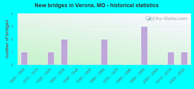
- New bridges - historical statistics
- 11900-1909
- 11920-1929
- 21930-1939
- 21960-1969
- 31990-1999
- 12010-2019
- 12020-2022


- Bridge Condition - Deck
- 16.7%Excellent
- 33.3%Good
- 50.0%Satisfactory

- Bridge Condition - Superstructure
- 16.7%Very good
- 33.3%Good
- 50.0%Satisfactory

- Bridge Condition - Substructure
- 16.7%Excellent
- 33.3%Good
- 33.3%Satisfactory
- 16.7%Poor

- Bridge Condition - Channel
- 20.0%Good
- 20.0%Satisfactory
- 40.0%Fair
- 20.0%Poor

- Bridge Condition - Culverts
- 25.0%Very good
- 50.0%Satisfactory
- 25.0%Fair
Find on map >> Show street view
Structure Number: 23859, Location: S 17 T 26 N R 26 W (Lat: 36.959133, Lng: -93.800311), Route carried "on" structure: City street , Year Built: 1990, Status: Open, Structure Length: 3.51m (11.52ft), Average Daily Traffic: 300 (year 2021), Truck Traffic: 10%, Average Future Daily Traffic: 420 (year 2041), Design Load: HS 20, Features Intersected: SPRING RVR, Facility Carried by Structure: MAIN ST
Minimum Vertical Clearance: 30+ m (98+ ft), Kilometerpoint: 0.161, Lanes on structure: 2, Owner: County Highway Agency, Maintenance Responsibility: City or Municipal Highway Agency, Approaching Roadway Width: 7.0m (23.0ft), Skew: 2 degrees, Material/Design: Prestressed concrete, Design/Construction: Tee Beam, Number Of Spans In Main Unit: 3, Length of Maximum Span: 11.8m (38.7ft), Curb-To-Curb Width: 7.3m (24.0ft), Out-to-Out Width: 8.2m (26.9ft)
Condition: Deck: Good, Superstructure: Good, Substructure: Good, Channel: Good, Operating Rating: 49.5 metric tons, Method Used To Determine Operating Rating: Allowable Stress (AS), Inventory Rating: 29.7 metric tons, Method Used To Determine Inventory Rating: Allowable Stress (AS), Structural Evaluation: Better than present minimum criteria, Deck Geometry: Somewhat better than minimum adequacy, Waterway Adequacy: Equal to present desirable criteria, Approach Roadway Alignment: Equal to present desirable criteria, Designated Inspection Frequency: Every 24 months, Inspection Date: March 2021, Deck Structure Type: Concrete Cast-file-Place, Wearing Surface/Protective System: Wearing Surface: Monolithic Concrete
Find on map >> Show street view
Structure Number: 25209, Location: S 31 T 27 N R 26 W (Lat: 37.003994, Lng: -93.825169), Route carried "on" structure: County highway 684, Year Built: 1930, Status: Posted for load, Structure Length: 1.52m (4.99ft), Average Daily Traffic: 75 (year 2021), Truck Traffic: 10%, Average Future Daily Traffic: 105 (year 2041), Design Load: H 10, Features Intersected: SPRING RVR, Facility Carried by Structure: COUNTY RD 2187
Minimum Vertical Clearance: 30+ m (98+ ft), Kilometerpoint: 0.161, Lanes on structure: 1, Owner: County Highway Agency, Approaching Roadway Width: 5.2m (17.1ft), Material/Design: Concrete, Design/Construction: Slab, Number Of Spans In Main Unit: 2, Length of Maximum Span: 6.7m (22.0ft), Curb-To-Curb Width: 4.9m (16.1ft), Out-to-Out Width: 4.9m (16.1ft)
Condition: Deck: Satisfactory, Superstructure: Satisfactory, Substructure: Poor, Channel: Poor, Operating Rating: 13.5 metric tons, Method Used To Determine Operating Rating: Allowable Stress (AS), Inventory Rating: 7.2 metric tons, Method Used To Determine Inventory Rating: Allowable Stress (AS), Structural Evaluation: High priority of replacement, Deck Geometry: High priority of corrective action, Waterway Adequacy: High priority of corrective action, Approach Roadway Alignment: Somewhat better than minimum adequacy, Bridge Posting: Required (Relationship of Operating Rating to Maximum Legal Load: > 39.9% below), Length Of Structure Improvement: 0.22m (0.72ft), Designated Inspection Frequency: Every 24 months, Inspection Date: March 2021, Bridge Improvement Cost: $160,000, Roadway Improvement Cost: $16,000, Total Project Cost: $240,000 ( Estimate for 2022), Deck Structure Type: Concrete Cast-file-Place, Wearing Surface/Protective System: Wearing Surface: Monolithic Concrete
Find on map >> Show street view
Structure Number: 25218, Location: S 28 T 26 N R 26 W (Lat: 36.935125, Lng: -93.791631), Route carried "on" structure: County highway 692, Year Built: 1900, Year Reconstructed: 1930, Status: Posted for load, Structure Length: 0.76m (2.49ft), Average Daily Traffic: 200 (year 2021), Truck Traffic: 10%, Average Future Daily Traffic: 280 (year 2041), Design Load: H 10, Features Intersected: TRIB SPRING RVR, Facility Carried by Structure: COUNTY RD 1150
Minimum Vertical Clearance: 30+ m (98+ ft), Kilometerpoint: 1.287, Lanes on structure: 2, Owner: County Highway Agency, Approaching Roadway Width: 5.5m (18.0ft), Material/Design: Concrete, Design/Construction: Slab, Number Of Spans In Main Unit: 2, Length of Maximum Span: 3.0m (9.8ft), Curb-To-Curb Width: 7.4m (24.3ft), Out-to-Out Width: 7.4m (24.3ft)
Condition: Deck: Satisfactory, Superstructure: Satisfactory, Substructure: Satisfactory, Channel: Fair, Operating Rating: 13.5 metric tons, Method Used To Determine Operating Rating: Allowable Stress (AS), Inventory Rating: 8.1 metric tons, Method Used To Determine Inventory Rating: Allowable Stress (AS), Structural Evaluation: High priority of corrective action, Deck Geometry: Somewhat better than minimum adequacy, Waterway Adequacy: Better than present minimum criteria, Approach Roadway Alignment: Equal to present desirable criteria, Bridge Posting: Required (Relationship of Operating Rating to Maximum Legal Load: > 39.9% below), Length Of Structure Improvement: 0.14m (0.46ft), Designated Inspection Frequency: Every 24 months, Inspection Date: March 2021, Bridge Improvement Cost: $69,000, Roadway Improvement Cost: $7,000, Total Project Cost: $104,000 ( Estimate for 2022), Deck Structure Type: Concrete Cast-file-Place, Wearing Surface/Protective System: Wearing Surface: Bituminous
Find on map >> Show street view
Structure Number: 25272, Location: S 8 T 26 N R 26 W (Lat: 36.973922, Lng: -93.798072), Route carried "on" structure: County highway 812, Year Built: 1999, Status: Open, Structure Length: 1.34m (4.40ft), Average Daily Traffic: 100 (year 2021), Truck Traffic: 10%, Average Future Daily Traffic: 140 (year 2041), Design Load: HS 20, Features Intersected: SPRING RVR, Facility Carried by Structure: COUNTY RD 2210
Minimum Vertical Clearance: 30+ m (98+ ft), Kilometerpoint: 2.736, Lanes on structure: 2, Owner: County Highway Agency, Approaching Roadway Width: 6.1m (20.0ft), Material/Design: Concrete continuous, Design/Construction: Culvert, Number Of Spans In Main Unit: 3, Length of Maximum Span: 4.3m (14.1ft), Curb-To-Curb Width: 7.3m (24.0ft), Out-to-Out Width: 8.2m (26.9ft)
Condition: Channel: Satisfactory, Culverts: Very good, Operating Rating: 36.0 metric tons, Method Used To Determine Operating Rating: Load Factor (LF), Inventory Rating: 32.4 metric tons, Method Used To Determine Inventory Rating: Load Factor (LF), Structural Evaluation: Equal to present desirable criteria, Deck Geometry: Equal to present minimum criteria, Waterway Adequacy: Better than present minimum criteria, Approach Roadway Alignment: Equal to present desirable criteria, Designated Inspection Frequency: Every 24 months, Inspection Date: March 2021, Deck Structure Type: Concrete Cast-file-Place, Wearing Surface/Protective System: Wearing Surface: Bituminous
Find on map >> Show street view
Structure Number: 25275, Location: S 28 T 26 N R 26 W (Lat: 36.926633, Lng: -93.789719), Route carried "on" structure: County highway 883, Year Built: 1938, Status: Open, Structure Length: 0.76m (2.49ft), Average Daily Traffic: 100 (year 2021), Truck Traffic: 10%, Average Future Daily Traffic: 140 (year 2041), Design Load: H 15, Features Intersected: TRIB SPRING RVR, Facility Carried by Structure: COUNTY RD 2240
Minimum Vertical Clearance: 30+ m (98+ ft), Kilometerpoint: 0.161, Lanes on structure: 2, Owner: County Highway Agency, Approaching Roadway Width: 7.3m (24.0ft), Material/Design: Concrete, Design/Construction: Culvert, Number Of Spans In Main Unit: 2, Length of Maximum Span: 3.7m (12.1ft), Curb-To-Curb Width: 7.9m (25.9ft), Out-to-Out Width: 8.5m (27.9ft)
Condition: Channel: Poor, Culverts: Fair, Operating Rating: 35.1 metric tons, Method Used To Determine Operating Rating: Allowable Stress (AS), Inventory Rating: 18.9 metric tons, Method Used To Determine Inventory Rating: Allowable Stress (AS), Structural Evaluation: Somewhat better than minimum adequacy, Deck Geometry: Equal to present minimum criteria, Waterway Adequacy: Better than present minimum criteria, Approach Roadway Alignment: Equal to present desirable criteria, Designated Inspection Frequency: Every 24 months, Inspection Date: March 2021, Deck Structure Type: Concrete Cast-file-Place, Wearing Surface/Protective System: Wearing Surface: Bituminous
Find on map >> Show street view
Structure Number: 3327, Location: S 20 T 26 N R 26 W (Lat: 36.948703, Lng: -93.793594), Route carried "on" structure: Business State highway 60, Year Built: 2010, Status: Open, Structure Length: 5.51m (18.08ft), Average Daily Traffic: 1,303 (year 2021), Truck Traffic: 4%, Average Future Daily Traffic: 1,889 (year 2041), Design Load: HS 20, Features Intersected: SPRING RVR
Minimum Vertical Clearance: 30+ m (98+ ft), Kilometerpoint: 1.176, Lanes on structure: 2, Owner: State Highway Agency, Approaching Roadway Width: 9.8m (32.2ft), Skew: 3 degrees, Material/Design: Prestressed concrete, Design/Construction: Box Beam or Girders - Single/Spread, Number Of Spans In Main Unit: 3, Length of Maximum Span: 18.3m (60.0ft), Curb-To-Curb Width: 9.8m (32.2ft), Out-to-Out Width: 10.4m (34.1ft)
Condition: Deck: Satisfactory, Superstructure: Satisfactory, Substructure: Good, Channel: Fair, Operating Rating: 83.7 metric tons, Method Used To Determine Operating Rating: Load Factor (LF), Inventory Rating: 40.5 metric tons, Method Used To Determine Inventory Rating: Load Factor (LF), Structural Evaluation: Equal to present minimum criteria, Deck Geometry: Somewhat better than minimum adequacy, Waterway Adequacy: Superior to present desirable criteria, Approach Roadway Alignment: Equal to present desirable criteria, Designated Inspection Frequency: Every 24 months, Inspection Date: July 2020, Deck Structure Type: Concrete Cast-file-Place, Wearing Surface/Protective System: Wearing Surface: Monolithic Concrete, Deck Protection: Epoxy Coated Reinforcing
Find on map >> Show street view
Structure Number: 36313, Location: S 6 T 26 N R 26 W (Lat: 36.997731, Lng: -93.816694), Route carried "on" structure: County highway 774, Year Built: 2020, Status: Open, Structure Length: 2.42m (7.94ft), Average Daily Traffic: 50 (year 2021), Truck Traffic: 10%, Average Future Daily Traffic: 70 (year 2041), Design Load: HS 20, Features Intersected: SPRING RVR, Facility Carried by Structure: CRD 2193
Minimum Vertical Clearance: 30+ m (98+ ft), Kilometerpoint: 0.805, Lanes on structure: 2, Owner: County Highway Agency, Approaching Roadway Width: 5.5m (18.0ft), Skew: 1 degrees, Material/Design: Prestressed concrete, Design/Construction: Tee Beam, Number Of Spans In Main Unit: 1, Length of Maximum Span: 23.5m (77.1ft), Curb-To-Curb Width: 7.3m (24.0ft), Out-to-Out Width: 7.5m (24.6ft)
Condition: Deck: Excellent, Superstructure: Very good, Substructure: Excellent, Channel: Good, Operating Rating: 70.2 metric tons, Method Used To Determine Operating Rating: Load Factor (LF), Inventory Rating: 54.0 metric tons, Method Used To Determine Inventory Rating: Load Factor (LF), Structural Evaluation: Equal to present desirable criteria, Deck Geometry: Equal to present minimum criteria, Waterway Adequacy: Equal to present desirable criteria, Approach Roadway Alignment: Equal to present minimum criteria, Designated Inspection Frequency: Every 24 months, Inspection Date: March 2021, Deck Structure Type: Concrete Cast-file-Place, Wearing Surface/Protective System: Wearing Surface: Monolithic Concrete
Find on map >> Show street view
Structure Number: 4254, Location: S 8 T 26 N R 26 W (Lat: 36.975158, Lng: -93.794989), Route carried "on" structure: State highway P, Year Built: 1995, Status: Open, Structure Length: 3.51m (11.52ft), Average Daily Traffic: 781 (year 2021), Truck Traffic: 18%, Average Future Daily Traffic: 1,132 (year 2041), Design Load: HS 20, Features Intersected: DOUGER BR
Minimum Vertical Clearance: 30+ m (98+ ft), Kilometerpoint: 7.002, Lanes on structure: 2, Owner: State Highway Agency, Approaching Roadway Width: 10.4m (34.1ft), Material/Design: Prestressed concrete continuous, Design/Construction: Stringer/Multi-beam, Number Of Spans In Main Unit: 3, Length of Maximum Span: 11.7m (38.4ft), Curb or Sidewalk Widths: Left: 0.2m (0.7ft), Right: 0.2m (0.7ft), Curb-To-Curb Width: 10.0m (32.8ft), Out-to-Out Width: 10.8m (35.4ft)
Condition: Deck: Good, Superstructure: Good, Substructure: Satisfactory, Channel: Fair, Operating Rating: 73.8 metric tons, Method Used To Determine Operating Rating: Load Factor (LF), Inventory Rating: 44.1 metric tons, Method Used To Determine Inventory Rating: Load Factor (LF), Structural Evaluation: Equal to present minimum criteria, Deck Geometry: Equal to present minimum criteria, Waterway Adequacy: Equal to present desirable criteria, Approach Roadway Alignment: Equal to present desirable criteria, Designated Inspection Frequency: Every 24 months, Inspection Date: July 2020, Deck Structure Type: Concrete Cast-file-Place, Wearing Surface/Protective System: Wearing Surface: Monolithic Concrete, Deck Protection: Epoxy Coated Reinforcing
Find on map >> Show street view
Structure Number: 5071, Location: S 15 T 26 N R 26 W (Lat: 36.958558, Lng: -93.795136), Route carried "on" structure: Business State highway 60, Year Built: 1927, Status: Open, Structure Length: 0.73m (2.40ft), Average Daily Traffic: 1,303 (year 2021), Truck Traffic: 4%, Average Future Daily Traffic: 1,889 (year 2041), Design Load: H 15, Features Intersected: VERONE CR
Minimum Vertical Clearance: 30+ m (98+ ft), Kilometerpoint: 2.321, Lanes on structure: 2, Owner: State Highway Agency, Approaching Roadway Width: 10.1m (33.1ft), Skew: 4 degrees, Material/Design: Concrete continuous, Design/Construction: Culvert, Number Of Spans In Main Unit: 2, Length of Maximum Span: 2.4m (7.9ft), Curb-To-Curb Width: 11.0m (36.1ft), Out-to-Out Width: 11.6m (38.1ft)
Condition: Channel: Fair, Culverts: Satisfactory, Operating Rating: 61.2 metric tons, Method Used To Determine Operating Rating: Load Factor (LF), Inventory Rating: 36.9 metric tons, Method Used To Determine Inventory Rating: Load Factor (LF), Structural Evaluation: Equal to present minimum criteria, Deck Geometry: Equal to present minimum criteria, Waterway Adequacy: Equal to present desirable criteria, Approach Roadway Alignment: Equal to present minimum criteria, Designated Inspection Frequency: Every 24 months, Inspection Date: April 2021
Find on map >> Show street view
Structure Number: 632, Location: S 20 T 26 N R 26 W (Lat: 36.942344, Lng: -93.799333), Route carried "on" structure: US 60, Year Built: 1961, Status: Open, Structure Length: 0.70m (2.30ft), Average Daily Traffic: 5,498 (year 2021), Truck Traffic: 11%, Average Future Daily Traffic: 10,446 (year 2041), Design Load: H 20, Features Intersected: SPRING RVR
Minimum Vertical Clearance: 30+ m (98+ ft), Kilometerpoint: 79.788, Lanes on structure: 2, Base Highway Network: Yes, Owner: State Highway Agency, Approaching Roadway Width: 13.4m (44.0ft), Skew: 2 degrees, Material/Design: Concrete continuous, Design/Construction: Culvert, Number Of Spans In Main Unit: 2, Length of Maximum Span: 3.0m (9.8ft)
Condition: Channel: Satisfactory, Culverts: Satisfactory, Structural Evaluation: Equal to present minimum criteria, Waterway Adequacy: Equal to present desirable criteria, Approach Roadway Alignment: Equal to present desirable criteria, Designated Inspection Frequency: Every 24 months, Inspection Date: April 2021
Find on map >> Show street view
Structure Number: 633, Location: S 20 T 26 N R 26 W (Lat: 36.944992, Lng: -93.791431), Route carried "under" structure: County highway 1150, Year Built: 1961, Structure Length: 0. m, Average Daily Traffic: 448 (year 2021), Truck Traffic: 10%, Features Intersected: CRD 1150, Facility Carried by Structure: US 60 E
Minimum Vertical Clearance: 8.38m (27.49ft), Kilometerpoint: 0.320, Lanes on structure: 2, Lanes under structure: 2, Material/Design: Steel continuous, Design/Construction: Stringer/Multi-beam, Length of Maximum Span: 35.0m (114.8ft)