Bridge Statistics for Verona, Virginia (VA)
Condition, Traffic, Stress, Structural Evaluation, Project Costs
- National Bridge Inventory (NBI) Statistics
- 25Number of bridges
- 220ft / 67.1mTotal length
- $1,505,000Total costs
- 378,700Total average daily traffic
- 65,512Total average daily truck traffic
- National Bridge Inventory (NBI) Registered Bridges for Verona
- No street view available for this location
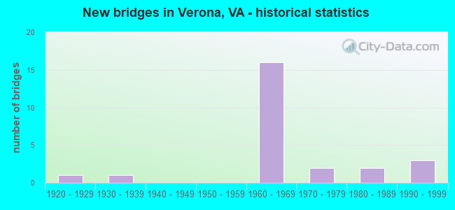
- New bridges - historical statistics
- 11920-1929
- 11930-1939
- 161960-1969
- 21970-1979
- 21980-1989
- 31990-1999


- Bridge Condition - Deck
- 7.1%Very good
- 35.7%Good
- 28.6%Satisfactory
- 28.6%Fair

- Bridge Condition - Superstructure
- 14.3%Very good
- 21.4%Good
- 57.1%Satisfactory
- 7.1%Fair

- Bridge Condition - Substructure
- 14.3%Very good
- 21.4%Good
- 28.6%Satisfactory
- 35.7%Fair

- Bridge Condition - Channel
- 42.9%Very good
- 21.4%Good
- 21.4%Satisfactory
- 14.3%Fair

- Bridge Condition - Culverts
- 80.0%Satisfactory
- 20.0%Fair
Find on map >> Show street view
Structure Number: 1683, Location: 0.06 RT 781 - 0.26 RT 854 (Lat: 38.207967, Lng: -79.002933), Route carried "on" structure: US 11, Year Built: 1934, Year Reconstructed: 1988, Status: Open, Structure Length: 4.39m (14.40ft), Average Daily Traffic: 6,610 (year 2020), Truck Traffic: 2%, Average Future Daily Traffic: 7,271 (year 2040), Design Load: HS 20+Mod, Features Intersected: MIDDLE RIVER, Facility Carried by Structure: Lee-Jackson Hwy
Minimum Vertical Clearance: 30+ m (98+ ft), Kilometerpoint: 391.808, Lanes on structure: 3, Owner: State Highway Agency, Approaching Roadway Width: 14.6m (47.9ft), Material/Design: Steel continuous, Design/Construction: Stringer/Multi-beam, Number Of Spans In Main Unit: 2, Length of Maximum Span: 20.7m (67.9ft), Curb or Sidewalk Widths: Left: 1.7m (5.6ft), Right: 1.7m (5.6ft), Curb-To-Curb Width: 18.0m (59.1ft), Out-to-Out Width: 21.9m (71.9ft)
Condition: Deck: Satisfactory, Superstructure: Satisfactory, Substructure: Satisfactory, Channel: Good, Operating Rating: 57.2 metric tons, Method Used To Determine Operating Rating: Load and Resistance Factor (LRFR), Inventory Rating: 44.5 metric tons, Method Used To Determine Inventory Rating: Load and Resistance Factor (LRFR), Structural Evaluation: Equal to present minimum criteria, Deck Geometry: Superior to present desirable criteria, Waterway Adequacy: Equal to present minimum criteria, Approach Roadway Alignment: Equal to present desirable criteria, Designated Inspection Frequency: Every 24 months, Inspection Date: August 2020, Deck Structure Type: Concrete Cast-file-Place, Wearing Surface/Protective System: Wearing Surface: Epoxy Overlay, Deck Protection: Epoxy Coated Reinforcing
Find on map >> Show street view
Structure Number: 1785, Location: 0.48 TO 612 & 7.17 TO 256 (Lat: 38.199439, Lng: -78.994769), Route carried "on" structure: Interstate 81, Year Built: 1967, Status: Open, Structure Length: 5.44m (17.85ft), Average Daily Traffic: 24,263 (year 2020), Truck Traffic: 24%, Average Future Daily Traffic: 33,968 (year 2040), Design Load: HS 20+Mod, Features Intersected: NS RAILWAY SPUR
Minimum Vertical Clearance: 30+ m (98+ ft), Kilometerpoint: 367.882, Lanes on structure: 2, Base Highway Network: Yes, Owner: State Highway Agency, Approaching Roadway Width: 17.7m (58.1ft), Skew: 4 degrees, Material/Design: Steel, Design/Construction: Stringer/Multi-beam, Number Of Spans In Main Unit: 3, Length of Maximum Span: 17.5m (57.4ft), Curb or Sidewalk Widths: Left: 0.2m (0.7ft), Right: 0.2m (0.7ft), Curb-To-Curb Width: 11.8m (38.7ft), Out-to-Out Width: 12.8m (42.0ft)
Condition: Deck: Satisfactory, Superstructure: Satisfactory, Substructure: Satisfactory, Operating Rating: 62.6 metric tons, Method Used To Determine Operating Rating: Load and Resistance Factor (LRFR), Inventory Rating: 48.1 metric tons, Method Used To Determine Inventory Rating: Load and Resistance Factor (LRFR), Structural Evaluation: Equal to present minimum criteria, Deck Geometry: Equal to present minimum criteria, Approach Roadway Alignment: Equal to present desirable criteria, Designated Inspection Frequency: Every 24 months, Inspection Date: July 2021, Bridge Improvement Cost: $427,000, Total Project Cost: $435,000, Deck Structure Type: Concrete Cast-file-Place, Wearing Surface/Protective System: Wearing Surface: Epoxy Overlay
Find on map >> Show street view
Structure Number: 1786, Location: 0.48 TO 612 & 7.17 TO 256 (Lat: 38.199811, Lng: -78.995086), Route carried "on" structure: Alternate Interstate 81, Year Built: 1967, Status: Open, Structure Length: 5.44m (17.85ft), Average Daily Traffic: 23,588 (year 2020), Truck Traffic: 24%, Average Future Daily Traffic: 33,023 (year 2040), Design Load: HS 20+Mod, Features Intersected: NS RAILWAY SPUR
Minimum Vertical Clearance: 30+ m (98+ ft), Kilometerpoint: 368.364, Lanes on structure: 2, Base Highway Network: Yes, Owner: State Highway Agency, Approaching Roadway Width: 17.7m (58.1ft), Skew: 4 degrees, Material/Design: Steel, Design/Construction: Stringer/Multi-beam, Number Of Spans In Main Unit: 3, Length of Maximum Span: 17.5m (57.4ft), Curb or Sidewalk Widths: Left: 0.2m (0.7ft), Right: 0.2m (0.7ft), Curb-To-Curb Width: 11.8m (38.7ft), Out-to-Out Width: 12.8m (42.0ft)
Condition: Deck: Satisfactory, Superstructure: Satisfactory, Substructure: Fair, Operating Rating: 62.6 metric tons, Method Used To Determine Operating Rating: Load and Resistance Factor (LRFR), Inventory Rating: 48.1 metric tons, Method Used To Determine Inventory Rating: Load and Resistance Factor (LRFR), Structural Evaluation: Somewhat better than minimum adequacy, Deck Geometry: Equal to present minimum criteria, Approach Roadway Alignment: Equal to present desirable criteria, Designated Inspection Frequency: Every 24 months, Inspection Date: July 2021, Bridge Improvement Cost: $427,000, Total Project Cost: $435,000, Deck Structure Type: Concrete Cast-file-Place, Wearing Surface/Protective System: Wearing Surface: Other
Find on map >> Show street view
Structure Number: 1833, Location: 1.91 RT 275 - 0.08 RT 612 (Lat: 38.191297, Lng: -78.996767), Route carried "on" structure: Interstate 81, Year Built: 1968, Status: Open, Structure Length: 0.64m (2.10ft), Average Daily Traffic: 24,263 (year 2020), Truck Traffic: 24%, Average Future Daily Traffic: 33,968 (year 2040), Design Load: HS 20, Features Intersected: STREAM
Minimum Vertical Clearance: 30+ m (98+ ft), Kilometerpoint: 367.367, Lanes on structure: 2, Base Highway Network: Yes, Owner: State Highway Agency, Approaching Roadway Width: 14.0m (45.9ft), Skew: 2 degrees, Material/Design: Concrete, Design/Construction: Culvert, Number Of Spans In Main Unit: 3, Length of Maximum Span: 1.8m (5.9ft)
Condition: Channel: Fair, Culverts: Satisfactory, Operating Rating: 89.8 metric tons, Method Used To Determine Operating Rating: Field evaluation and documented engineering judgment, Inventory Rating: 88.9 metric tons, Method Used To Determine Inventory Rating: Field evaluation and documented engineering judgment, Structural Evaluation: Equal to present minimum criteria, Waterway Adequacy: Superior to present desirable criteria, Approach Roadway Alignment: Equal to present desirable criteria, Designated Inspection Frequency: Every 24 months, Inspection Date: January 2022
Find on map >> Show street view
Structure Number: 1834, Location: 1.91 RT 275 - 0.08 RT 612 (Lat: 38.191486, Lng: -78.997214), Route carried "on" structure: Interstate 81, Year Built: 1966, Status: Open, Structure Length: 0.64m (2.10ft), Average Daily Traffic: 24,720 (year 2020), Truck Traffic: 24%, Average Future Daily Traffic: 34,608 (year 2040), Design Load: HS 20, Features Intersected: STREAM
Minimum Vertical Clearance: 30+ m (98+ ft), Kilometerpoint: 367.431, Lanes on structure: 2, Base Highway Network: Yes, Owner: State Highway Agency, Approaching Roadway Width: 17.7m (58.1ft), Skew: 2 degrees, Material/Design: Concrete, Design/Construction: Culvert, Number Of Spans In Main Unit: 3, Length of Maximum Span: 1.8m (5.9ft)
Condition: Channel: Satisfactory, Culverts: Satisfactory, Operating Rating: 89.8 metric tons, Method Used To Determine Operating Rating: Load Factor (LF), Inventory Rating: 88.9 metric tons, Method Used To Determine Inventory Rating: Load Factor (LF), Structural Evaluation: Equal to present minimum criteria, Waterway Adequacy: Superior to present desirable criteria, Approach Roadway Alignment: Equal to present desirable criteria, Designated Inspection Frequency: Every 24 months, Inspection Date: January 2022
Find on map >> Show street view
Structure Number: 1835, Location: 0.17 I-81 - 0.08 RT 612 (Lat: 38.191819, Lng: -78.998014), Route carried "on" structure: Ramp Interstate 81, Year Built: 1966, Status: Open, Structure Length: 0.67m (2.20ft), Average Daily Traffic: 1,594 (year 2020), Average Future Daily Traffic: 2,233 (year 2040), Design Load: HS 20, Features Intersected: STREAM
Minimum Vertical Clearance: 30+ m (98+ ft), Kilometerpoint: 0.338, Lanes on structure: 1, Base Highway Network: Yes, Owner: State Highway Agency, Approaching Roadway Width: 8.6m (28.2ft), Skew: 3 degrees, Material/Design: Concrete, Design/Construction: Culvert, Number Of Spans In Main Unit: 3, Length of Maximum Span: 1.8m (5.9ft)
Condition: Channel: Good, Culverts: Satisfactory, Operating Rating: 89.8 metric tons, Method Used To Determine Operating Rating: Field evaluation and documented engineering judgment, Inventory Rating: 88.9 metric tons, Method Used To Determine Inventory Rating: Field evaluation and documented engineering judgment, Structural Evaluation: Equal to present minimum criteria, Waterway Adequacy: Equal to present desirable criteria, Approach Roadway Alignment: Equal to present desirable criteria, Designated Inspection Frequency: Every 24 months, Inspection Date: March 2020
Find on map >> Show street view
Structure Number: 1849, Location: 3.11 RT 250 - 2.01 RT 612 (Lat: 38.166297, Lng: -79.010317), Route carried "on" structure: Interstate 81, Year Built: 1968, Status: Open, Structure Length: 4.61m (15.12ft), Average Daily Traffic: 25,517 (year 2020), Truck Traffic: 25%, Average Future Daily Traffic: 35,724 (year 2040), Design Load: HS 20+Mod, Features Intersected: RT 262
Minimum Vertical Clearance: 30+ m (98+ ft), Kilometerpoint: 363.859, Lanes on structure: 2, Lanes under structure: 5, Base Highway Network: Yes, Owner: State Highway Agency, Approaching Roadway Width: 11.8m (38.7ft), Material/Design: Steel continuous, Design/Construction: Stringer/Multi-beam, Number Of Spans In Main Unit: 2, Length of Maximum Span: 23.0m (75.5ft), Curb or Sidewalk Widths: Left: 0.2m (0.7ft), Right: 0.2m (0.7ft), Curb-To-Curb Width: 11.8m (38.7ft), Out-to-Out Width: 12.8m (42.0ft)
Condition: Deck: Satisfactory, Superstructure: Satisfactory, Substructure: Fair, Operating Rating: 42.5 metric tons, Method Used To Determine Operating Rating: Load and Resistance Factor (LRFR), Inventory Rating: 32.8 metric tons, Method Used To Determine Inventory Rating: Load and Resistance Factor (LRFR), Structural Evaluation: Somewhat better than minimum adequacy, Deck Geometry: Equal to present minimum criteria, Underclear: Equal to present minimum criteria, Approach Roadway Alignment: Equal to present desirable criteria, Length Of Structure Improvement: 4.60m (15.09ft), Designated Inspection Frequency: Every 24 months, Inspection Date: September 2021, Bridge Improvement Cost: $219,000, Total Project Cost: $224,000, Deck Structure Type: Concrete Cast-file-Place, Wearing Surface/Protective System: Wearing Surface: Epoxy Overlay
Find on map >> Show street view
Structure Number: 1851, Location: 3.11 RT 250 - 2.01 RT 612 (Lat: 38.166556, Lng: -79.010703), Route carried "on" structure: Interstate 81, Year Built: 1968, Status: Open, Structure Length: 4.61m (15.12ft), Average Daily Traffic: 25,172 (year 2020), Truck Traffic: 23%, Average Future Daily Traffic: 35,241 (year 2040), Design Load: HS 20+Mod, Features Intersected: RTE 262
Minimum Vertical Clearance: 30+ m (98+ ft), Kilometerpoint: 364.326, Lanes on structure: 2, Lanes under structure: 4, Base Highway Network: Yes, Owner: State Highway Agency, Approaching Roadway Width: 11.8m (38.7ft), Material/Design: Steel continuous, Design/Construction: Stringer/Multi-beam, Number Of Spans In Main Unit: 2, Length of Maximum Span: 23.0m (75.5ft), Curb or Sidewalk Widths: Left: 0.2m (0.7ft), Right: 0.2m (0.7ft), Curb-To-Curb Width: 11.8m (38.7ft), Out-to-Out Width: 12.8m (42.0ft)
Condition: Deck: Fair, Superstructure: Satisfactory, Substructure: Fair, Operating Rating: 53.5 metric tons, Method Used To Determine Operating Rating: Load and Resistance Factor (LRFR), Inventory Rating: 41.7 metric tons, Method Used To Determine Inventory Rating: Load and Resistance Factor (LRFR), Structural Evaluation: Somewhat better than minimum adequacy, Deck Geometry: Equal to present minimum criteria, Underclear: Equal to present minimum criteria, Approach Roadway Alignment: Equal to present desirable criteria, Length Of Structure Improvement: 4.60m (15.09ft), Designated Inspection Frequency: Every 24 months, Inspection Date: September 2021, Bridge Improvement Cost: $219,000, Total Project Cost: $224,000, Deck Structure Type: Concrete Cast-file-Place, Wearing Surface/Protective System: Wearing Surface: Epoxy Overlay
Find on map >> Show street view
Structure Number: 1891, Location: 0.20 RT 795 - 0.32 RT 839 (Lat: 38.160131, Lng: -78.965233), Route carried "on" structure: State highway 254, Year Built: 1972, Status: Open, Structure Length: 6.13m (20.11ft), Average Daily Traffic: 6,035 (year 2020), Truck Traffic: 4%, Average Future Daily Traffic: 6,638 (year 2040), Design Load: HS 20+Mod, Features Intersected: CHRISTIANS CREEK, Facility Carried by Structure: HERMITAGE RD
Minimum Vertical Clearance: 30+ m (98+ ft), Kilometerpoint: 26.391, Lanes on structure: 2, Base Highway Network: Yes, Owner: State Highway Agency, Approaching Roadway Width: 7.7m (25.3ft), Material/Design: Steel, Design/Construction: Stringer/Multi-beam, Number Of Spans In Main Unit: 3, Length of Maximum Span: 20.2m (66.3ft), Curb or Sidewalk Widths: Left: 0.2m (0.7ft), Right: 0.2m (0.7ft), Curb-To-Curb Width: 10.6m (34.8ft), Out-to-Out Width: 11.6m (38.1ft)
Condition: Deck: Good, Superstructure: Satisfactory, Substructure: Fair, Channel: Very good, Operating Rating: 64.4 metric tons, Method Used To Determine Operating Rating: Load and Resistance Factor (LRFR), Inventory Rating: 49.9 metric tons, Method Used To Determine Inventory Rating: Load and Resistance Factor (LRFR), Structural Evaluation: Somewhat better than minimum adequacy, Deck Geometry: Meets minimum limits, Waterway Adequacy: Better than present minimum criteria, Approach Roadway Alignment: Better than present minimum criteria, Designated Inspection Frequency: Every 24 months, Inspection Date: January 2022, Deck Structure Type: Concrete Cast-file-Place, Wearing Surface/Protective System: Wearing Surface: Epoxy Overlay
Find on map >> Show street view
Structure Number: 1912, Location: 0.17 TO 932 - 0.02 TO 790 (Lat: 38.163928, Lng: -79.004931), Route carried "on" structure: State highway 262, Year Built: 1968, Status: Open, Structure Length: 4.41m (14.47ft), Average Daily Traffic: 5,908 (year 2020), Truck Traffic: 3%, Average Future Daily Traffic: 6,800 (year 2040), Design Load: HS 20+Mod, Features Intersected: LEWIS CREEK, Facility Carried by Structure: WOODROW WILSON PKY
Minimum Vertical Clearance: 30+ m (98+ ft), Kilometerpoint: 9.144, Lanes on structure: 2, Base Highway Network: Yes, Owner: State Highway Agency, Approaching Roadway Width: 7.1m (23.3ft), Material/Design: Concrete, Design/Construction: Tee Beam, Number Of Spans In Main Unit: 3, Length of Maximum Span: 14.5m (47.6ft), Curb or Sidewalk Widths: Left: 0.2m (0.7ft), Right: 0.2m (0.7ft), Curb-To-Curb Width: 10.0m (32.8ft), Out-to-Out Width: 10.9m (35.8ft)
Condition: Deck: Good, Superstructure: Good, Substructure: Fair, Channel: Very good, Operating Rating: 49.9 metric tons, Method Used To Determine Operating Rating: Load and Resistance Factor (LRFR), Inventory Rating: 38.1 metric tons, Method Used To Determine Inventory Rating: Load and Resistance Factor (LRFR), Structural Evaluation: Somewhat better than minimum adequacy, Deck Geometry: Meets minimum limits, Waterway Adequacy: Equal to present minimum criteria, Approach Roadway Alignment: Equal to present desirable criteria, Designated Inspection Frequency: Every 24 months, Inspection Date: July 2020, Deck Structure Type: Concrete Cast-file-Place, Wearing Surface/Protective System: Wearing Surface: Epoxy Overlay
Find on map >> Show street view
Structure Number: 1999, Location: 1.08 RT 742 - 0.91 RT 612 (Lat: 38.221514, Lng: -79.058731), Route carried "on" structure: County highway 613, Year Built: 1971, Status: Open, Structure Length: 0.64m (2.10ft), Average Daily Traffic: 1,512 (year 2020), Truck Traffic: 1%, Average Future Daily Traffic: 1,880 (year 2040), Design Load: HS 20, Features Intersected: WET WEATHER STREAM, Facility Carried by Structure: Spring Hill Rd
Minimum Vertical Clearance: 30+ m (98+ ft), Kilometerpoint: 21.829, Lanes on structure: 2, Owner: State Highway Agency, Approaching Roadway Width: 6.7m (22.0ft), Skew: 4 degrees, Material/Design: Steel, Design/Construction: Culvert, Number Of Spans In Main Unit: 2, Length of Maximum Span: 1.8m (5.9ft)
Condition: Channel: Satisfactory, Culverts: Fair, Operating Rating: 41.7 metric tons, Method Used To Determine Operating Rating: Field evaluation and documented engineering judgment, Inventory Rating: 24.5 metric tons, Method Used To Determine Inventory Rating: Field evaluation and documented engineering judgment, Structural Evaluation: Somewhat better than minimum adequacy, Waterway Adequacy: Better than present minimum criteria, Approach Roadway Alignment: Better than present minimum criteria, Designated Inspection Frequency: Every 24 months, Inspection Date: November 2020
Find on map >> Show street view
Structure Number: 2269, Location: 0.06 RT 743 - 1.72 RT 745 (Lat: 38.243300, Lng: -79.035458), Route carried "on" structure: County highway 742, Year Built: 1987, Status: Open, Structure Length: 4.33m (14.21ft), Average Daily Traffic: 219 (year 2016), Average Future Daily Traffic: 280 (year 2040), Design Load: HS 20+Mod, Features Intersected: MIDDLE RIVER, Facility Carried by Structure: LEBANON CHURCH RD
Minimum Vertical Clearance: 30+ m (98+ ft), Kilometerpoint: 10.587, Lanes on structure: 2, Owner: State Highway Agency, Approaching Roadway Width: 5.5m (18.0ft), Skew: 1 degrees, Material/Design: Steel, Design/Construction: Stringer/Multi-beam, Number Of Spans In Main Unit: 2, Length of Maximum Span: 21.6m (70.9ft), Curb-To-Curb Width: 7.5m (24.6ft), Out-to-Out Width: 8.5m (27.9ft)
Condition: Deck: Good, Superstructure: Good, Substructure: Very good, Channel: Very good, Operating Rating: 66.2 metric tons, Method Used To Determine Operating Rating: Load and Resistance Factor (LRFR), Inventory Rating: 51.7 metric tons, Method Used To Determine Inventory Rating: Load and Resistance Factor (LRFR), Structural Evaluation: Better than present minimum criteria, Deck Geometry: Somewhat better than minimum adequacy, Waterway Adequacy: Better than present minimum criteria, Approach Roadway Alignment: Equal to present desirable criteria, Designated Inspection Frequency: Every 24 months, Inspection Date: May 2021, Deck Structure Type: Concrete Cast-file-Place, Wearing Surface/Protective System: Deck Protection: Epoxy Coated Reinforcing
Find on map >> Show street view
Structure Number: 2328, Location: 0.47 RT 11 - 0.11 RT 780 (Lat: 38.205400, Lng: -78.993025), Route carried "on" structure: County highway 781, Year Built: 1966, Status: Open, Structure Length: 9.58m (31.43ft), Average Daily Traffic: 514 (year 2016), Average Future Daily Traffic: 591 (year 2040), Design Load: HS 20+Mod, Features Intersected: RTE 81, Facility Carried by Structure: Mill Race Road
Minimum Vertical Clearance: 30+ m (98+ ft), Kilometerpoint: 4.459, Lanes on structure: 4, Lanes under structure: 4, Owner: State Highway Agency, Approaching Roadway Width: 7.3m (24.0ft), Skew: 2 degrees, Material/Design: Prestressed concrete, Design/Construction: Stringer/Multi-beam, Number Of Spans In Main Unit: 5, Length of Maximum Span: 21.0m (68.9ft), Curb or Sidewalk Widths: Left: 0.5m (1.6ft), Right: 0.5m (1.6ft), Curb-To-Curb Width: 7.3m (24.0ft), Out-to-Out Width: 8.8m (28.9ft)
Condition: Deck: Fair, Superstructure: Satisfactory, Substructure: Satisfactory, Operating Rating: 51.7 metric tons, Method Used To Determine Operating Rating: Load and Resistance Factor (LRFR), Inventory Rating: 32.7 metric tons, Method Used To Determine Inventory Rating: Load and Resistance Factor (LRFR), Structural Evaluation: Equal to present minimum criteria, Deck Geometry: High priority of replacement, Underclear: Somewhat better than minimum adequacy, Approach Roadway Alignment: Equal to present desirable criteria, Designated Inspection Frequency: Every 24 months, Inspection Date: Febuary 2021, Bridge Improvement Cost: $44,000, Total Project Cost: $46,000, Deck Structure Type: Concrete Cast-file-Place, Wearing Surface/Protective System: Wearing Surface: Bituminous
Find on map >> Show street view
Structure Number: 2338, Location: 0.70 TO 789 & 0.07 TO 790 (Lat: 38.174586, Lng: -78.990419), Route carried "on" structure: County highway 792, Year Built: 1966, Status: Open, Structure Length: 3.04m (9.97ft), Average Daily Traffic: 1,808 (year 2020), Truck Traffic: 2%, Average Future Daily Traffic: 1,989 (year 2040), Design Load: HS 20+Mod, Features Intersected: LEWIS CREEK, Facility Carried by Structure: INDIAN MOUND RD
Minimum Vertical Clearance: 30+ m (98+ ft), Kilometerpoint: 8.785, Lanes on structure: 2, Owner: State Highway Agency, Approaching Roadway Width: 6.4m (21.0ft), Material/Design: Concrete, Design/Construction: Tee Beam, Number Of Spans In Main Unit: 3, Length of Maximum Span: 9.8m (32.2ft), Curb or Sidewalk Widths: Left: 0.2m (0.7ft), Right: 0.2m (0.7ft), Curb-To-Curb Width: 8.8m (28.9ft), Out-to-Out Width: 9.8m (32.2ft)
Condition: Deck: Good, Superstructure: Good, Substructure: Good, Channel: Fair, Operating Rating: 48.1 metric tons, Method Used To Determine Operating Rating: Load and Resistance Factor (LRFR), Inventory Rating: 36.3 metric tons, Method Used To Determine Inventory Rating: Load and Resistance Factor (LRFR), Structural Evaluation: Better than present minimum criteria, Deck Geometry: Somewhat better than minimum adequacy, Waterway Adequacy: Better than present minimum criteria, Approach Roadway Alignment: Equal to present desirable criteria, Designated Inspection Frequency: Every 24 months, Inspection Date: June 2021, Deck Structure Type: Concrete Cast-file-Place, Wearing Surface/Protective System: Wearing Surface: Epoxy Overlay
Find on map >> Show street view
Structure Number: 2343, Location: 0.43 RT 254 - 1.28 RT 807 (Lat: 38.157517, Lng: -78.972536), Route carried "on" structure: County highway 795, Year Built: 1988, Status: Open, Structure Length: 3.35m (10.99ft), Average Daily Traffic: 688 (year 2013), Average Future Daily Traffic: 1,060 (year 2040), Design Load: HS 20+Mod, Features Intersected: CHRISTIANS CREEK, Facility Carried by Structure: St. James Road
Minimum Vertical Clearance: 30+ m (98+ ft), Kilometerpoint: 1.641, Lanes on structure: 2, Owner: State Highway Agency, Approaching Roadway Width: 6.1m (20.0ft), Skew: 2 degrees, Material/Design: Prestressed concrete, Design/Construction: Box Beam or Girders - Multiple, Number Of Spans In Main Unit: 2, Length of Maximum Span: 16.8m (55.1ft), Curb-To-Curb Width: 8.1m (26.6ft), Out-to-Out Width: 9.1m (29.9ft)
Condition: Deck: Fair, Superstructure: Fair, Substructure: Good, Channel: Satisfactory, Operating Rating: 73.5 metric tons, Method Used To Determine Operating Rating: Load and Resistance Factor (LRFR), Inventory Rating: 57.2 metric tons, Method Used To Determine Inventory Rating: Load and Resistance Factor (LRFR), Structural Evaluation: Somewhat better than minimum adequacy, Deck Geometry: Somewhat better than minimum adequacy, Waterway Adequacy: Somewhat better than minimum adequacy, Approach Roadway Alignment: Equal to present minimum criteria, Designated Inspection Frequency: Every 24 months, Inspection Date: October 2020, Deck Structure Type: Other, Wearing Surface/Protective System: Wearing Surface: Epoxy Overlay, Membrane: Preformed Fabric
Find on map >> Show street view
Structure Number: 2408, Location: 0.10DEADEND - 0.05 TO 790 (Lat: 38.166297, Lng: -79.003350), Route carried "on" structure: County highway 931, Year Built: 1923, Status: Posted for load, Structure Length: 0.93m (3.05ft), Average Daily Traffic: 8 (year 2013), Average Future Daily Traffic: 9 (year 2040), Features Intersected: LEWIS CREEK, Facility Carried by Structure: LEWIS CROSSING LN
Minimum Vertical Clearance: 30+ m (98+ ft), Kilometerpoint: 0.048, Lanes on structure: 1, Owner: State Highway Agency, Approaching Roadway Width: 2.7m (8.9ft), Material/Design: Steel, Design/Construction: Stringer/Multi-beam, Number Of Spans In Main Unit: 1, Length of Maximum Span: 8.5m (27.9ft), Curb or Sidewalk Widths: Left: 0.2m (0.7ft), Right: 0.2m (0.7ft), Curb-To-Curb Width: 4.7m (15.4ft), Out-to-Out Width: 4.9m (16.1ft)
Condition: Deck: Fair, Superstructure: Satisfactory, Substructure: Satisfactory, Channel: Very good, Operating Rating: 12.7 metric tons, Method Used To Determine Operating Rating: Load and Resistance Factor (LRFR), Inventory Rating: 10.0 metric tons, Method Used To Determine Inventory Rating: Load and Resistance Factor (LRFR), Structural Evaluation: High priority of corrective action, Deck Geometry: Better than present minimum criteria, Waterway Adequacy: Better than present minimum criteria, Approach Roadway Alignment: Better than present minimum criteria, Bridge Posting: Required (Relationship of Operating Rating to Maximum Legal Load: > 39.9% below), Length Of Structure Improvement: 0.94m (3.08ft), Designated Inspection Frequency: Every 12 months, Inspection Date: July 2021, Bridge Improvement Cost: $128,000, Roadway Improvement Cost: $13,000, Total Project Cost: $141,000, Deck Structure Type: Wood or Timber, Wearing Surface/Protective System: Wearing Surface: Bituminous
Find on map >> Show street view
Structure Number: 24966, Location: 0.40 RT 612 - 0.97 RT 787 (Lat: 38.183142, Lng: -78.962850), Route carried "on" structure: County highway 642, Year Built: 1997, Status: Open, Structure Length: 3.08m (10.10ft), Average Daily Traffic: 376 (year 2013), Average Future Daily Traffic: 427 (year 2040), Design Load: HS 20+Mod, Features Intersected: CHRISTIANS CREEK, Facility Carried by Structure: BARREN RIDGE RD
Minimum Vertical Clearance: 30+ m (98+ ft), Kilometerpoint: 12.277, Lanes on structure: 2, Owner: State Highway Agency, Approaching Roadway Width: 7.2m (23.6ft), Skew: 3 degrees, Material/Design: Prestressed concrete, Design/Construction: Box Beam or Girders - Multiple, Number Of Spans In Main Unit: 2, Length of Maximum Span: 14.3m (46.9ft), Curb-To-Curb Width: 9.2m (30.2ft), Out-to-Out Width: 9.8m (32.2ft)
Condition: Deck: Very good, Superstructure: Very good, Substructure: Good, Channel: Good, Operating Rating: 74.4 metric tons, Method Used To Determine Operating Rating: Load and Resistance Factor (LRFR), Inventory Rating: 57.2 metric tons, Method Used To Determine Inventory Rating: Load and Resistance Factor (LRFR), Structural Evaluation: Better than present minimum criteria, Deck Geometry: Equal to present minimum criteria, Waterway Adequacy: Equal to present minimum criteria, Approach Roadway Alignment: Equal to present minimum criteria, Designated Inspection Frequency: Every 24 months, Inspection Date: May 2021, Deck Structure Type: Other, Wearing Surface/Protective System: Wearing Surface: Bituminous, Membrane: Preformed Fabric
Find on map >> Show street view
Structure Number: 24968, Location: 0.57 RT 1916- 0.17 RT 906 (Lat: 38.209794, Lng: -78.977467), Route carried "on" structure: County highway 780, Year Built: 1997, Status: Open, Structure Length: 4.40m (14.44ft), Average Daily Traffic: 251 (year 2013), Average Future Daily Traffic: 310 (year 2040), Features Intersected: MIDDLE RIVER, Facility Carried by Structure: WINDSWEPT RD
Minimum Vertical Clearance: 30+ m (98+ ft), Kilometerpoint: 1.377, Lanes on structure: 2, Owner: State Highway Agency, Approaching Roadway Width: 6.5m (21.3ft), Material/Design: Steel continuous, Design/Construction: Stringer/Multi-beam, Number Of Spans In Main Unit: 2, Length of Maximum Span: 20.8m (68.2ft), Curb-To-Curb Width: 8.6m (28.2ft), Out-to-Out Width: 9.2m (30.2ft)
Condition: Deck: Good, Superstructure: Very good, Substructure: Very good, Channel: Very good, Operating Rating: 78.0 metric tons, Method Used To Determine Operating Rating: Load and Resistance Factor (LRFR), Inventory Rating: 59.9 metric tons, Method Used To Determine Inventory Rating: Load and Resistance Factor (LRFR), Structural Evaluation: Equal to present desirable criteria, Deck Geometry: Equal to present minimum criteria, Waterway Adequacy: Better than present minimum criteria, Approach Roadway Alignment: Equal to present desirable criteria, Designated Inspection Frequency: Every 24 months, Inspection Date: July 2021, Deck Structure Type: Concrete Cast-file-Place, Wearing Surface/Protective System: Deck Protection: Epoxy Coated Reinforcing
Find on map >> Show street view
Structure Number: 26726, Location: 0.12 RT 612 - 0.60 END (Lat: 38.192639, Lng: -79.001369), Route carried "on" structure: State highway 1943, Year Built: 1999, Status: Open, Structure Length: 0.81m (2.66ft), Average Daily Traffic: 808 (year 2020), Average Future Daily Traffic: 889 (year 2040), Design Load: HS 20, Features Intersected: STREAM, Facility Carried by Structure: MILL PLACE PKWY
Minimum Vertical Clearance: 30+ m (98+ ft), Kilometerpoint: 0.177, Lanes on structure: 2, Owner: State Highway Agency, Approaching Roadway Width: 11.3m (37.1ft), Skew: 3 degrees, Material/Design: Concrete, Design/Construction: Culvert, Number Of Spans In Main Unit: 2, Length of Maximum Span: 3.3m (10.8ft)
Condition: Channel: Very good, Culverts: Satisfactory, Operating Rating: 44.5 metric tons, Method Used To Determine Operating Rating: Field evaluation and documented engineering judgment, Inventory Rating: 32.7 metric tons, Method Used To Determine Inventory Rating: Field evaluation and documented engineering judgment, Structural Evaluation: Equal to present minimum criteria, Waterway Adequacy: Superior to present desirable criteria, Approach Roadway Alignment: Equal to present desirable criteria, Designated Inspection Frequency: Every 24 months, Inspection Date: April 2021
Find on map >> Show street view
Structure Number: 1849, Location: 3.11 RT 250 - 2.01 RT 612 (Lat: 38.166297, Lng: -79.010317), Route carried "under" structure: State highway 262, Year Built: 1968, Structure Length: 0. m, Average Daily Traffic: 12,000 (year 2018), Truck Traffic: 3%, Features Intersected: RT 262, Facility Carried by Structure: NBL ROUTE 0081
Minimum Vertical Clearance: 5.21m (17.09ft), Kilometerpoint: 8.608, Lanes on structure: 2, Lanes under structure: 5, Material/Design: Steel continuous, Design/Construction: Stringer/Multi-beam, Length of Maximum Span: 23.0m (75.5ft)
Find on map >> Show street view
Structure Number: 1851, Location: 3.11 RT 250 - 2.01 RT 612 (Lat: 38.166556, Lng: -79.010703), Route carried "under" structure: State highway 262, Year Built: 1968, Structure Length: 0. m, Average Daily Traffic: 5,500 (year 2018), Truck Traffic: 3%, Features Intersected: RTE 262, Facility Carried by Structure: SBL ROUTE 0081
Minimum Vertical Clearance: 5.13m (16.83ft), Kilometerpoint: 8.576, Lanes on structure: 2, Lanes under structure: 4, Material/Design: Steel continuous, Design/Construction: Stringer/Multi-beam, Length of Maximum Span: 23.0m (75.5ft)
Find on map >> Show street view
Structure Number: 1989, Location: 0.74 TO 818 & 0.30 TO 792 (Lat: 38.192817, Lng: -78.997189), Route carried "under" structure: Interstate 81, Year Built: 1968, Structure Length: 0. m, Average Daily Traffic: 50,000 (year 2014), Truck Traffic: 25%, Features Intersected: I-81, Facility Carried by Structure: LAUREL HILL RD
Minimum Vertical Clearance: 5.16m (16.93ft), Kilometerpoint: 365.627, Lanes on structure: 2, Lanes under structure: 4, Material/Design: Prestressed concrete, Design/Construction: Stringer/Multi-beam, Length of Maximum Span: 20.7m (67.9ft)
Find on map >> Show street view
Structure Number: 1991, Location: 0.74 TO 818 & 0.30 TO 792 (Lat: 38.192983, Lng: -78.997142), Route carried "under" structure: Interstate 81, Year Built: 1968, Structure Length: 0. m, Average Daily Traffic: 45,782 (year 2008), Truck Traffic: 12%, Features Intersected: I-81, Facility Carried by Structure: LAUREL HILL RD
Minimum Vertical Clearance: 5.13m (16.83ft), Kilometerpoint: 367.126, Lanes on structure: 2, Lanes under structure: 4, Material/Design: Prestressed concrete, Design/Construction: Stringer/Multi-beam, Length of Maximum Span: 20.7m (67.9ft)
Find on map >> Show street view
Structure Number: 2273, Location: 0.25 RT 11 - 0.25 RT 816 (Lat: 38.228781, Lng: -78.977025), Route carried "under" structure: Interstate 81, Year Built: 1966, Structure Length: 0. m, Average Daily Traffic: 45,782 (year 2008), Truck Traffic: 12%, Features Intersected: RTE 81, Facility Carried by Structure: Toll Gate Road
Minimum Vertical Clearance: 5.30m (17.39ft), Kilometerpoint: 371.582, Lanes on structure: 2, Lanes under structure: 4, Material/Design: Prestressed concrete, Design/Construction: Stringer/Multi-beam, Length of Maximum Span: 20.1m (65.9ft)
Find on map >> Show street view
Structure Number: 2328, Location: 0.47 RT 11 - 0.11 RT 780 (Lat: 38.205400, Lng: -78.993025), Route carried "under" structure: Interstate 81, Year Built: 1966, Structure Length: 0. m, Average Daily Traffic: 45,782 (year 2008), Truck Traffic: 12%, Features Intersected: RTE 81, Facility Carried by Structure: Mill Race Road
Minimum Vertical Clearance: 5.41m (17.75ft), Kilometerpoint: 368.574, Lanes on structure: 4, Lanes under structure: 4, Material/Design: Prestressed concrete, Design/Construction: Stringer/Multi-beam, Length of Maximum Span: 21.0m (68.9ft)