Bridge Statistics for Vian, Oklahoma (OK)
Condition, Traffic, Stress, Structural Evaluation, Project Costs
- National Bridge Inventory (NBI) Statistics
- 18Number of bridges
- 197ft / 59.6mTotal length
- $17,838,000Total costs
- 126,155Total average daily traffic
- 40,356Total average daily truck traffic
- National Bridge Inventory (NBI) Registered Bridges for Vian
- No street view available for this location
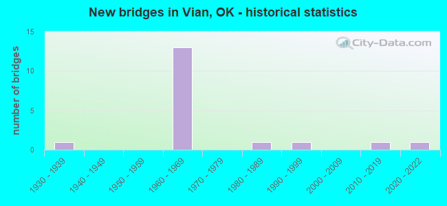
- New bridges - historical statistics
- 11930-1939
- 131960-1969
- 11980-1989
- 11990-1999
- 12010-2019
- 12020-2022


- Bridge Condition - Deck
- 22.2%Very good
- 11.1%Good
- 33.3%Satisfactory
- 33.3%Fair

- Bridge Condition - Superstructure
- 33.3%Very good
- 33.3%Good
- 11.1%Satisfactory
- 22.2%Fair

- Bridge Condition - Substructure
- 22.2%Very good
- 22.2%Good
- 44.4%Satisfactory
- 11.1%Fair

- Bridge Condition - Channel
- 22.2%Very good
- 66.7%Satisfactory
- 11.1%Fair
Find on map >> Show street view
Structure Number: 6939, Location: 10.05 E JCT SH-10 (Lat: 35.463617, Lng: -94.922883), Route carried "on" structure: US 64, Year Built: 1939, Status: Open, Structure Length: 0.70m (2.30ft), Average Daily Traffic: 3,000 (year 2020), Truck Traffic: 15%, Average Future Daily Traffic: 4,800 (year 2040), Design Load: H 20, Features Intersected: W BRANCH W NEGRO CREEK
Minimum Vertical Clearance: 30+ m (98+ ft), Kilometerpoint: 16.171, Lanes on structure: 2, Owner: State Highway Agency, Approaching Roadway Width: 11.0m (36.1ft), Material/Design: Concrete, Design/Construction: Culvert, Number Of Spans In Main Unit: 2, Length of Maximum Span: 3.0m (9.8ft)
Condition: Channel: Satisfactory, Culverts: Satisfactory, Operating Rating: 32.7 metric tons, Method Used To Determine Operating Rating: Load Factor (LF), Inventory Rating: 19.6 metric tons, Method Used To Determine Inventory Rating: Load Factor (LF), Structural Evaluation: Somewhat better than minimum adequacy, Waterway Adequacy: Equal to present desirable criteria, Approach Roadway Alignment: Better than present minimum criteria, Length Of Structure Improvement: 0.70m (2.30ft), Designated Inspection Frequency: Every 24 months, Inspection Date: October 2021, Bridge Improvement Cost: $230,000, Roadway Improvement Cost: $380,000, Total Project Cost: $644,000 ( Estimate for 2015)
Find on map >> Show street view
Structure Number: 15268, Location: 8.36 E JCT SH-10 (Lat: 35.480592, Lng: -94.941211), Route carried "on" structure: US 64, Year Built: 1961, Status: Open, Structure Length: 1.04m (3.41ft), Average Daily Traffic: 3,100 (year 2020), Truck Traffic: 15%, Average Future Daily Traffic: 4,960 (year 2040), Design Load: HS 20, Features Intersected: BOGGY HOLLOW CREEK
Minimum Vertical Clearance: 30+ m (98+ ft), Kilometerpoint: 13.451, Lanes on structure: 2, Owner: State Highway Agency, Approaching Roadway Width: 9.8m (32.2ft), Material/Design: Concrete, Design/Construction: Culvert, Number Of Spans In Main Unit: 3, Length of Maximum Span: 3.0m (9.8ft)
Condition: Channel: Satisfactory, Culverts: Satisfactory, Operating Rating: 52.9 metric tons, Method Used To Determine Operating Rating: Load Factor (LF), Inventory Rating: 31.8 metric tons, Method Used To Determine Inventory Rating: Load Factor (LF), Structural Evaluation: Equal to present minimum criteria, Waterway Adequacy: Equal to present minimum criteria, Approach Roadway Alignment: Equal to present desirable criteria, Length Of Structure Improvement: 1.01m (3.31ft), Designated Inspection Frequency: Every 24 months, Inspection Date: October 2021, Bridge Improvement Cost: $230,000, Roadway Improvement Cost: $380,000, Total Project Cost: $644,000 ( Estimate for 2015)
Find on map >> Show street view
Structure Number: 15367, Location: 7.46 E JCT SH-10 (Lat: 35.490486, Lng: -94.951689), Route carried "on" structure: US 64, Year Built: 1961, Status: Open, Structure Length: 5.52m (18.11ft), Average Daily Traffic: 3,100 (year 2020), Truck Traffic: 15%, Average Future Daily Traffic: 4,960 (year 2040), Design Load: H 20, Features Intersected: LITTLE VIAN CREEK
Minimum Vertical Clearance: 30+ m (98+ ft), Kilometerpoint: 19.317, Lanes on structure: 2, Owner: State Highway Agency, Approaching Roadway Width: 9.8m (32.2ft), Material/Design: Steel, Design/Construction: Stringer/Multi-beam, Number Of Spans In Main Unit: 3, Length of Maximum Span: 18.3m (60.0ft), Curb or Sidewalk Widths: Left: 0.5m (1.6ft), Right: 0.5m (1.6ft), Curb-To-Curb Width: 8.5m (27.9ft), Out-to-Out Width: 9.4m (30.8ft)
Condition: Deck: Fair, Superstructure: Good, Substructure: Fair, Channel: Satisfactory, Operating Rating: 45.1 metric tons, Method Used To Determine Operating Rating: Load Factor (LF), Inventory Rating: 27.0 metric tons, Method Used To Determine Inventory Rating: Load Factor (LF), Structural Evaluation: Somewhat better than minimum adequacy, Deck Geometry: Meets minimum limits, Waterway Adequacy: Better than present minimum criteria, Approach Roadway Alignment: Better than present minimum criteria, Length Of Structure Improvement: 8.53m (27.99ft), Designated Inspection Frequency: Every 24 months, Inspection Date: October 2021, Bridge Improvement Cost: $698,000, Roadway Improvement Cost: $1,152,000, Total Project Cost: $1,955,000 ( Estimate for 2015), Deck Structure Type: Concrete Cast-file-Place, Wearing Surface/Protective System: Wearing Surface: Monolithic Concrete
Find on map >> Show street view
Structure Number: 16876, Location: 9.28 E MUSKOGEE C/L (Lat: 35.473161, Lng: -94.945150), Route carried "on" structure: Interstate 40, Year Built: 1967, Status: Open, Structure Length: 1.04m (3.41ft), Average Daily Traffic: 17,300 (year 2020), Truck Traffic: 36%, Average Future Daily Traffic: 27,680 (year 2040), Design Load: HS 20, Features Intersected: HARAWAY CREEK
Minimum Vertical Clearance: 30+ m (98+ ft), Kilometerpoint: 14.931, Lanes on structure: 4, Base Highway Network: Yes, Owner: State Highway Agency, Approaching Roadway Width: 25.6m (84.0ft), Skew: 20 degrees, Material/Design: Concrete, Design/Construction: Culvert, Number Of Spans In Main Unit: 3, Length of Maximum Span: 3.0m (9.8ft)
Condition: Channel: Satisfactory, Culverts: Satisfactory, Operating Rating: 90.7 metric tons, Method Used To Determine Operating Rating: Load Factor (LF), Inventory Rating: 90.4 metric tons, Method Used To Determine Inventory Rating: Load Factor (LF), Structural Evaluation: Equal to present minimum criteria, Waterway Adequacy: Equal to present desirable criteria, Approach Roadway Alignment: Equal to present desirable criteria, Length Of Structure Improvement: 1.04m (3.41ft), Designated Inspection Frequency: Every 24 months, Inspection Date: October 2021, Bridge Improvement Cost: $375,000, Roadway Improvement Cost: $619,000, Total Project Cost: $1,050,000 ( Estimate for 2015)
Find on map >> Show street view
Structure Number: 16878, Location: 10.94 E MUSKOGEE C/L (Lat: 35.459386, Lng: -94.921219), Route carried "on" structure: Interstate 40, Year Built: 1967, Status: Open, Structure Length: 1.04m (3.41ft), Average Daily Traffic: 17,300 (year 2020), Truck Traffic: 36%, Average Future Daily Traffic: 27,680 (year 2040), Design Load: HS 20, Features Intersected: NEGRO CREEK
Minimum Vertical Clearance: 30+ m (98+ ft), Kilometerpoint: 17.601, Lanes on structure: 4, Base Highway Network: Yes, Owner: State Highway Agency, Approaching Roadway Width: 11.6m (38.1ft), Skew: 20 degrees, Material/Design: Concrete, Design/Construction: Culvert, Number Of Spans In Main Unit: 3, Length of Maximum Span: 3.0m (9.8ft)
Condition: Channel: Fair, Culverts: Satisfactory, Operating Rating: 90.7 metric tons, Method Used To Determine Operating Rating: Load Factor (LF), Inventory Rating: 90.4 metric tons, Method Used To Determine Inventory Rating: Load Factor (LF), Structural Evaluation: Equal to present minimum criteria, Waterway Adequacy: Equal to present minimum criteria, Approach Roadway Alignment: Equal to present desirable criteria, Length Of Structure Improvement: 1.04m (3.41ft), Designated Inspection Frequency: Every 24 months, Inspection Date: October 2021, Bridge Improvement Cost: $395,000, Roadway Improvement Cost: $651,000, Total Project Cost: $1,105,000 ( Estimate for 2015)
Find on map >> Show street view
Structure Number: 16946, Location: 7.35 E MUSKOGEE C/L (Lat: 35.488636, Lng: -94.973067), Route carried "on" structure: Interstate 40, Year Built: 1967, Year Reconstructed: 2021, Status: Open, Structure Length: 3.51m (11.52ft), Average Daily Traffic: 8,200 (year 2020), Truck Traffic: 36%, Average Future Daily Traffic: 13,120 (year 2040), Design Load: HS 20, Features Intersected: S.H. 82 UNDER
Minimum Vertical Clearance: 30+ m (98+ ft), Kilometerpoint: 19.032, Lanes on structure: 2, Lanes under structure: 2, Base Highway Network: Yes, Owner: State Highway Agency, Approaching Roadway Width: 11.6m (38.1ft), Skew: 10 degrees, Material/Design: Steel, Design/Construction: Stringer/Multi-beam, Number Of Spans In Main Unit: 3, Length of Maximum Span: 14.3m (46.9ft), Curb or Sidewalk Widths: Left: 0.4m (1.3ft), Right: 0.4m (1.3ft), Curb-To-Curb Width: 11.3m (37.1ft), Out-to-Out Width: 12.1m (39.7ft)
Condition: Deck: Very good, Superstructure: Fair, Substructure: Satisfactory, Operating Rating: 51.1 metric tons, Method Used To Determine Operating Rating: Load Factor (LF), Inventory Rating: 30.6 metric tons, Method Used To Determine Inventory Rating: Load Factor (LF), Structural Evaluation: Somewhat better than minimum adequacy, Deck Geometry: Somewhat better than minimum adequacy, Underclear: Somewhat better than minimum adequacy, Approach Roadway Alignment: Equal to present desirable criteria, Length Of Structure Improvement: 5.61m (18.41ft), Designated Inspection Frequency: Every 24 months, Inspection Date: October 2021, Bridge Improvement Cost: $487,000, Roadway Improvement Cost: $804,000, Total Project Cost: $1,364,000 ( Estimate for 2015), Deck Structure Type: Concrete Cast-file-Place, Wearing Surface/Protective System: Wearing Surface: Monolithic Concrete
Find on map >> Show street view
Structure Number: 16947, Location: 7.35 E MUSKOGEE C/L (Lat: 35.488942, Lng: -94.972567), Route carried "on" structure: Interstate 40, Year Built: 1967, Status: Closed, Structure Length: 3.51m (11.52ft), Average Daily Traffic: 8,300 (year 2020), Truck Traffic: 36%, Average Future Daily Traffic: 13,280 (year 2040), Design Load: HS 20, Features Intersected: S.H. 82 UNDER
Minimum Vertical Clearance: 30+ m (98+ ft), Kilometerpoint: 19.032, Lanes on structure: 2, Lanes under structure: 2, Base Highway Network: Yes, Owner: State Highway Agency, Approaching Roadway Width: 11.6m (38.1ft), Skew: 10 degrees, Material/Design: Steel, Design/Construction: Stringer/Multi-beam, Number Of Spans In Main Unit: 3, Length of Maximum Span: 14.3m (46.9ft), Curb or Sidewalk Widths: Left: 0.4m (1.3ft), Right: 0.4m (1.3ft), Curb-To-Curb Width: 11.3m (37.1ft), Out-to-Out Width: 12.1m (39.7ft)
Condition: Deck: Fair, Superstructure: Fair, Substructure: Satisfactory, Deck Geometry: Somewhat better than minimum adequacy, Underclear: Meets minimum limits, Approach Roadway Alignment: Equal to present desirable criteria, Length Of Structure Improvement: 5.61m (18.41ft), Designated Inspection Frequency: Every 24 months, Inspection Date: October 2021, Bridge Improvement Cost: $487,000, Roadway Improvement Cost: $804,000, Total Project Cost: $1,364,000 ( Estimate for 2015), Deck Structure Type: Concrete Cast-file-Place, Wearing Surface/Protective System: Wearing Surface: Monolithic Concrete
Find on map >> Show street view
Structure Number: 16964, Location: 11.00 E MUSKOGEE C/L (Lat: 35.459181, Lng: -94.920297), Route carried "on" structure: County highway N4550, Year Built: 1967, Status: Open, Structure Length: 7.01m (23.00ft), Average Daily Traffic: 125 (year 2020), Truck Traffic: 15%, Average Future Daily Traffic: 200 (year 2040), Design Load: H 15, Features Intersected: I-40 UNDER
Minimum Vertical Clearance: 30+ m (98+ ft), Kilometerpoint: 17.700, Lanes on structure: 2, Lanes under structure: 4, Owner: State Highway Agency, Approaching Roadway Width: 7.3m (24.0ft), Skew: 2 degrees, Material/Design: Steel continuous, Design/Construction: Stringer/Multi-beam, Number Of Spans In Main Unit: 2, Number Of Approach Spans: 2, Length of Maximum Span: 24.4m (80.1ft), Curb or Sidewalk Widths: Left: 0.6m (2.0ft), Right: 0.6m (2.0ft), Curb-To-Curb Width: 7.3m (24.0ft), Out-to-Out Width: 8.5m (27.9ft)
Condition: Deck: Satisfactory, Superstructure: Very good, Substructure: Good, Operating Rating: 38.6 metric tons, Method Used To Determine Operating Rating: Load Factor (LF), Inventory Rating: 23.0 metric tons, Method Used To Determine Inventory Rating: Load Factor (LF), Structural Evaluation: Equal to present minimum criteria, Deck Geometry: Somewhat better than minimum adequacy, Underclear: Meets minimum limits, Approach Roadway Alignment: Better than present minimum criteria, Length Of Structure Improvement: 9.19m (30.15ft), Designated Inspection Frequency: Every 24 months, Inspection Date: October 2021, Bridge Improvement Cost: $745,000, Roadway Improvement Cost: $1,229,000, Total Project Cost: $2,085,000 ( Estimate for 2015), Deck Structure Type: Concrete Cast-file-Place, Wearing Surface/Protective System: Wearing Surface: Monolithic Concrete
Find on map >> Show street view
Structure Number: 17007, Location: 10.01 E MUSKOGEE C/L (Lat: 35.466531, Lng: -94.935317), Route carried "on" structure: County highway N4540, Year Built: 1967, Status: Open, Structure Length: 6.43m (21.10ft), Average Daily Traffic: 250 (year 2020), Truck Traffic: 19%, Average Future Daily Traffic: 400 (year 2040), Design Load: H 15, Features Intersected: I-40 UNDER
Minimum Vertical Clearance: 30+ m (98+ ft), Kilometerpoint: 16.106, Lanes on structure: 2, Lanes under structure: 4, Owner: State Highway Agency, Approaching Roadway Width: 7.3m (24.0ft), Material/Design: Steel continuous, Design/Construction: Stringer/Multi-beam, Number Of Spans In Main Unit: 2, Number Of Approach Spans: 2, Length of Maximum Span: 22.3m (73.2ft), Curb or Sidewalk Widths: Left: 0.6m (2.0ft), Right: 0.6m (2.0ft), Curb-To-Curb Width: 7.3m (24.0ft), Out-to-Out Width: 8.5m (27.9ft)
Condition: Deck: Satisfactory, Superstructure: Good, Substructure: Good, Operating Rating: 33.9 metric tons, Method Used To Determine Operating Rating: Load Factor (LF), Inventory Rating: 20.3 metric tons, Method Used To Determine Inventory Rating: Load Factor (LF), Structural Evaluation: Somewhat better than minimum adequacy, Deck Geometry: Somewhat better than minimum adequacy, Underclear: High priority of replacement, Approach Roadway Alignment: Better than present minimum criteria, Length Of Structure Improvement: 8.40m (27.56ft), Designated Inspection Frequency: Every 24 months, Inspection Date: October 2021, Bridge Improvement Cost: $1,196,000, Roadway Improvement Cost: $1,974,000, Total Project Cost: $3,350,000 ( Estimate for 2015), Deck Structure Type: Concrete Cast-file-Place, Wearing Surface/Protective System: Wearing Surface: Monolithic Concrete
Find on map >> Show street view
Structure Number: 17011, Location: 8.44 E MUSKOGEE C/L (Lat: 35.481242, Lng: -94.955792), Route carried "on" structure: Interstate 40, Year Built: 1967, Status: Closed, Structure Length: 6.40m (21.00ft), Average Daily Traffic: 8,950 (year 2020), Truck Traffic: 36%, Average Future Daily Traffic: 14,320 (year 2040), Design Load: HS 20, Features Intersected: LITTLE VIAN CREEK
Minimum Vertical Clearance: 30+ m (98+ ft), Kilometerpoint: 21.855, Lanes on structure: 2, Base Highway Network: Yes, Owner: State Highway Agency, Approaching Roadway Width: 11.6m (38.1ft), Skew: 13 degrees, Material/Design: Steel continuous, Design/Construction: Stringer/Multi-beam, Number Of Spans In Main Unit: 4, Length of Maximum Span: 24.4m (80.1ft), Curb or Sidewalk Widths: Left: 0.4m (1.3ft), Right: 0.4m (1.3ft), Curb-To-Curb Width: 11.6m (38.1ft), Out-to-Out Width: 12.4m (40.7ft)
Condition: Deck: Fair, Superstructure: Satisfactory, Substructure: Satisfactory, Channel: Satisfactory, Deck Geometry: Equal to present minimum criteria, Waterway Adequacy: Equal to present desirable criteria, Approach Roadway Alignment: Equal to present desirable criteria, Length Of Structure Improvement: 9.23m (30.28ft), Designated Inspection Frequency: Every 24 months, Inspection Date: October 2021, Bridge Improvement Cost: $747,000, Roadway Improvement Cost: $1,233,000, Total Project Cost: $2,092,000 ( Estimate for 2015), Deck Structure Type: Concrete Cast-file-Place, Wearing Surface/Protective System: Wearing Surface: Monolithic Concrete
Find on map >> Show street view
Structure Number: 20013, Location: .5 E 1.1 S BEARDEN (Lat: 35.332781, Lng: -96.370597), Route carried "on" structure: County highway 5446C, Year Built: 1982, Status: Open, Structure Length: 0.85m (2.79ft), Average Daily Traffic: 100 (year 2020), Truck Traffic: 15%, Average Future Daily Traffic: 160 (year 2040), Design Load: HS 20, Features Intersected: CREEK
Minimum Vertical Clearance: 30+ m (98+ ft), Kilometerpoint: 4.665, Lanes on structure: 2, Owner: County Highway Agency, Approaching Roadway Width: 6.1m (20.0ft), Skew: 6 degrees, Material/Design: Concrete, Design/Construction: Culvert, Number Of Spans In Main Unit: 3, Length of Maximum Span: 2.4m (7.9ft), Curb-To-Curb Width: 8.5m (27.9ft), Out-to-Out Width: 9.1m (29.9ft)
Condition: Channel: Satisfactory, Culverts: Satisfactory, Operating Rating: 54.4 metric tons, Method Used To Determine Operating Rating: Load Factor (LF), Inventory Rating: 32.7 metric tons, Method Used To Determine Inventory Rating: Load Factor (LF), Structural Evaluation: Equal to present minimum criteria, Deck Geometry: Better than present minimum criteria, Waterway Adequacy: Better than present minimum criteria, Approach Roadway Alignment: Equal to present desirable criteria, Length Of Structure Improvement: 3.17m (10.40ft), Designated Inspection Frequency: Every 24 months, Inspection Date: July 2020, Bridge Improvement Cost: $100,000, Roadway Improvement Cost: $75,000, Total Project Cost: $225,000 ( Estimate for 2015), Wearing Surface/Protective System: Wearing Surface: Gravel
Find on map >> Show street view
Structure Number: 22878, Location: 2.78 N JCT US-64 (Lat: 35.537022, Lng: -94.970172), Route carried "on" structure: State highway 82, Year Built: 1991, Status: Open, Structure Length: 5.55m (18.21ft), Average Daily Traffic: 2,800 (year 2020), Truck Traffic: 15%, Average Future Daily Traffic: 4,480 (year 2040), Design Load: HS 20, Features Intersected: VIAN CREEK
Minimum Vertical Clearance: 30+ m (98+ ft), Kilometerpoint: 4.472, Lanes on structure: 2, Owner: State Highway Agency, Approaching Roadway Width: 12.2m (40.0ft), Material/Design: Prestressed concrete, Design/Construction: Stringer/Multi-beam, Number Of Spans In Main Unit: 3, Length of Maximum Span: 18.3m (60.0ft), Curb or Sidewalk Widths: Left: 0.2m (0.7ft), Right: 0.2m (0.7ft), Curb-To-Curb Width: 12.3m (40.4ft), Out-to-Out Width: 12.9m (42.3ft)
Condition: Deck: Satisfactory, Superstructure: Good, Substructure: Satisfactory, Channel: Very good, Operating Rating: 74.9 metric tons, Method Used To Determine Operating Rating: Load and Resistance Factor (LRFR), Inventory Rating: 37.6 metric tons, Method Used To Determine Inventory Rating: Load and Resistance Factor (LRFR), Structural Evaluation: Equal to present minimum criteria, Deck Geometry: Equal to present minimum criteria, Waterway Adequacy: Equal to present desirable criteria, Approach Roadway Alignment: Equal to present desirable criteria, Length Of Structure Improvement: 8.56m (28.08ft), Designated Inspection Frequency: Every 24 months, Inspection Date: October 2021, Bridge Improvement Cost: $700,000, Roadway Improvement Cost: $1,155,000, Total Project Cost: $1,960,000 ( Estimate for 2015), Deck Structure Type: Concrete Cast-file-Place, Wearing Surface/Protective System: Wearing Surface: Monolithic Concrete, Deck Protection: Epoxy Coated Reinforcing
Find on map >> Show street view
Structure Number: 29813, Location: 11.6E MUSKOGEE C/L (Lat: 35.473236, Lng: -94.935936), Route carried "on" structure: US 64, Year Built: 2015, Status: Open, Structure Length: 7.79m (25.56ft), Average Daily Traffic: 3,680 (year 2020), Truck Traffic: 6%, Average Future Daily Traffic: 5,469 (year 2040), Design Load: HL 93, Features Intersected: UP R.R. UNDER
Minimum Vertical Clearance: 30+ m (98+ ft), Kilometerpoint: 23.176, Lanes on structure: 4, Owner: State Highway Agency, Approaching Roadway Width: 12.3m (40.4ft), Skew: 2 degrees, Material/Design: Prestressed concrete, Design/Construction: Stringer/Multi-beam, Number Of Spans In Main Unit: 3, Length of Maximum Span: 36.0m (118.1ft), Curb-To-Curb Width: 12.2m (40.0ft), Out-to-Out Width: 12.9m (42.3ft)
Condition: Deck: Good, Superstructure: Very good, Substructure: Very good, Operating Rating: 60.1 metric tons, Method Used To Determine Operating Rating: Load and Resistance Factor (LRFR), Inventory Rating: 45.4 metric tons, Method Used To Determine Inventory Rating: Load and Resistance Factor (LRFR), Structural Evaluation: Equal to present desirable criteria, Deck Geometry: High priority of replacement, Underclear: Meets minimum limits, Approach Roadway Alignment: Equal to present desirable criteria, Designated Inspection Frequency: Every 24 months, Inspection Date: October 2021, Deck Structure Type: Concrete Cast-file-Place, Wearing Surface/Protective System: Wearing Surface: Monolithic Concrete, Deck Protection: Epoxy Coated Reinforcing
Find on map >> Show street view
Structure Number: 31733, Location: 8.44 E MUSKOGEE C/L (Lat: 35.481111, Lng: -94.956389), Route carried "on" structure: Interstate 40, Year Built: 2021, Status: Open, Structure Length: 9.25m (30.35ft), Average Daily Traffic: 8,950 (year 2020), Truck Traffic: 36%, Average Future Daily Traffic: 24,800 (year 2040), Design Load: HL 93, Features Intersected: LITTLE VIAN CREEK
Minimum Vertical Clearance: 30+ m (98+ ft), Kilometerpoint: 21.855, Lanes on structure: 2, Base Highway Network: Yes, Owner: State Highway Agency, Approaching Roadway Width: 11.6m (38.1ft), Skew: 3 degrees, Material/Design: Prestressed concrete, Design/Construction: Stringer/Multi-beam, Number Of Spans In Main Unit: 3, Length of Maximum Span: 33.5m (109.9ft), Curb-To-Curb Width: 11.6m (38.1ft), Out-to-Out Width: 12.5m (41.0ft)
Condition: Deck: Very good, Superstructure: Very good, Substructure: Very good, Channel: Very good, Operating Rating: 65.0 metric tons, Method Used To Determine Operating Rating: Load and Resistance Factor (LRFR), Inventory Rating: 50.2 metric tons, Method Used To Determine Inventory Rating: Load and Resistance Factor (LRFR), Structural Evaluation: Equal to present desirable criteria, Deck Geometry: Equal to present minimum criteria, Waterway Adequacy: Equal to present desirable criteria, Approach Roadway Alignment: Equal to present desirable criteria, Designated Inspection Frequency: Every 24 months, Inspection Date: October 2021, Deck Structure Type: Concrete Cast-file-Place, Wearing Surface/Protective System: Wearing Surface: Monolithic Concrete
Find on map >> Show street view
Structure Number: 16946, Location: 7.35 E MUSKOGEE C/L (Lat: 35.488636, Lng: -94.973067), Route carried "under" structure: State highway 82, Year Built: 1967, Structure Length: 0. m, Average Daily Traffic: 3,200 (year 2020), Truck Traffic: 15%, Features Intersected: S.H. 82 UNDER, Facility Carried by Structure: I-40
Minimum Vertical Clearance: 5.03m (16.50ft), Kilometerpoint: 0.000, Lanes on structure: 2, Lanes under structure: 2, Material/Design: Steel, Design/Construction: Stringer/Multi-beam, Length of Maximum Span: 14.3m (46.9ft)
Find on map >> Show street view
Structure Number: 16947, Location: 7.35 E MUSKOGEE C/L (Lat: 35.488942, Lng: -94.972567), Route carried "under" structure: State highway 82, Year Built: 1967, Structure Length: 0. m, Average Daily Traffic: 3,200 (year 2020), Truck Traffic: 15%, Features Intersected: S.H. 82 UNDER, Facility Carried by Structure: I-40
Minimum Vertical Clearance: 5.18m (16.99ft), Kilometerpoint: 0.032, Lanes on structure: 2, Lanes under structure: 2, Material/Design: Steel, Design/Construction: Stringer/Multi-beam, Length of Maximum Span: 14.3m (46.9ft)
Find on map >> Show street view
Structure Number: 16964, Location: 11.00 E MUSKOGEE C/L (Lat: 35.459181, Lng: -94.920297), Route carried "under" structure: Interstate 40, Year Built: 1967, Structure Length: 0. m, Average Daily Traffic: 17,300 (year 2020), Truck Traffic: 36%, Features Intersected: I-40 UNDER, Facility Carried by Structure: N4550 RD
Minimum Vertical Clearance: 5.15m (16.90ft), Kilometerpoint: 17.700, Lanes on structure: 2, Lanes under structure: 4, Material/Design: Steel continuous, Design/Construction: Stringer/Multi-beam, Length of Maximum Span: 24.4m (80.1ft)
Find on map >> Show street view
Structure Number: 17007, Location: 10.01 E MUSKOGEE C/L (Lat: 35.466531, Lng: -94.935317), Route carried "under" structure: Interstate 40, Year Built: 1967, Structure Length: 0. m, Average Daily Traffic: 17,300 (year 2020), Truck Traffic: 36%, Features Intersected: I-40 UNDER
Minimum Vertical Clearance: 5.09m (16.70ft), Kilometerpoint: 16.106, Lanes on structure: 2, Lanes under structure: 4, Material/Design: Steel continuous, Design/Construction: Stringer/Multi-beam, Length of Maximum Span: 22.3m (73.2ft)