Bridge Statistics for Vienna, Missouri (MO)
Condition, Traffic, Stress, Structural Evaluation, Project Costs
- National Bridge Inventory (NBI) Statistics
- 11Number of bridges
- 180ft / 55.2mTotal length
- $2,596,000Total costs
- 5,046Total average daily traffic
- 285Total average daily truck traffic
- 7,168Total future (year 2041) average daily traffic
- National Bridge Inventory (NBI) Registered Bridges for Vienna
- No street view available for this location
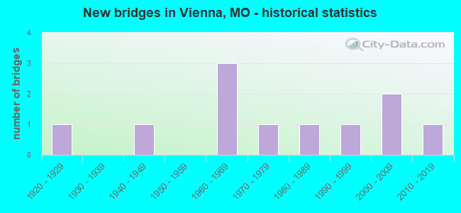
- New bridges - historical statistics
- 11920-1929
- 11940-1949
- 31960-1969
- 11970-1979
- 11980-1989
- 11990-1999
- 22000-2009
- 12010-2019

- Bridge Condition - Deck
- 14.3%Excellent
- 14.3%Good
- 28.6%Satisfactory
- 14.3%Fair
- 28.6%Poor

- Bridge Condition - Superstructure
- 28.6%Very good
- 42.9%Satisfactory
- 28.6%Fair

- Bridge Condition - Substructure
- 14.3%Excellent
- 14.3%Very good
- 28.6%Good
- 28.6%Satisfactory
- 14.3%Poor

- Bridge Condition - Channel
- 9.1%Very good
- 9.1%Good
- 36.4%Satisfactory
- 45.5%Fair

- Bridge Condition - Culverts
- 25.0%Good
- 50.0%Satisfactory
- 25.0%Fair
Find on map >> Show street view
Structure Number: 12092, Location: S 1 T 40 N R 10 W (Lat: 38.236967, Lng: -91.975289), Route carried "on" structure: State highway AA, Year Built: 2001, Status: Open, Structure Length: 0.94m (3.08ft), Average Daily Traffic: 313 (year 2021), Truck Traffic: 6%, Average Future Daily Traffic: 438 (year 2041), Design Load: HS 20+Mod, Features Intersected: TRIB MARIES RVR
Minimum Vertical Clearance: 30+ m (98+ ft), Kilometerpoint: 7.723, Lanes on structure: 2, Owner: State Highway Agency, Approaching Roadway Width: 11.0m (36.1ft), Material/Design: Concrete continuous, Design/Construction: Culvert, Number Of Spans In Main Unit: 2, Length of Maximum Span: 4.6m (15.1ft)
Condition: Channel: Very good, Culverts: Good, Inventory Rating: 86.4 metric tons, Method Used To Determine Inventory Rating: Load Factor (LF), Structural Evaluation: Better than present minimum criteria, Waterway Adequacy: Superior to present desirable criteria, Approach Roadway Alignment: Equal to present desirable criteria, Designated Inspection Frequency: Every 24 months, Inspection Date: August 2020
Find on map >> Show street view
Structure Number: 13126, Location: S 24 T 40 N R 10 W (Lat: 38.201278, Lng: -91.977556), Route carried "on" structure: County highway 29, Year Built: 1993, Status: Open, Structure Length: 7.38m (24.21ft), Average Daily Traffic: 75 (year 2021), Truck Traffic: 10%, Average Future Daily Traffic: 90 (year 2041), Design Load: HS 20, Features Intersected: MARIES RVR, Facility Carried by Structure: COUNTY RD 213
Minimum Vertical Clearance: 3.48m (11.42ft), Kilometerpoint: 4.828, Lanes on structure: 2, Owner: County Highway Agency, Approaching Roadway Width: 7.3m (24.0ft), Material/Design: Prestressed concrete, Design/Construction: Stringer/Multi-beam, Number Of Spans In Main Unit: 3, Length of Maximum Span: 27.4m (89.9ft), Curb-To-Curb Width: 7.3m (24.0ft), Out-to-Out Width: 8.1m (26.6ft)
Condition: Deck: Good, Superstructure: Very good, Substructure: Very good, Channel: Satisfactory, Operating Rating: 73.8 metric tons, Method Used To Determine Operating Rating: Allowable Stress (AS), Inventory Rating: 34.2 metric tons, Method Used To Determine Inventory Rating: Allowable Stress (AS), Structural Evaluation: Equal to present desirable criteria, Deck Geometry: High priority of corrective action, Waterway Adequacy: Better than present minimum criteria, Approach Roadway Alignment: Equal to present minimum criteria, Designated Inspection Frequency: Every 24 months, Inspection Date: April 2021, Deck Structure Type: Concrete Cast-file-Place, Wearing Surface/Protective System: Wearing Surface: Monolithic Concrete
Find on map >> Show street view
Structure Number: 13165, Location: S 26 T 40 N R 10 W (Lat: 38.177822, Lng: -92.002794), Route carried "on" structure: County highway 30, Year Built: 1940, Status: Posted for load, Structure Length: 4.30m (14.11ft), Average Daily Traffic: 40 (year 2021), Truck Traffic: 10%, Average Future Daily Traffic: 48 (year 2041), Features Intersected: MARIES RVR, Facility Carried by Structure: COUNTY RD 614
Minimum Vertical Clearance: 30+ m (98+ ft), Kilometerpoint: 3.219, Lanes on structure: 1, Owner: County Highway Agency, Approaching Roadway Width: 6.1m (20.0ft), Material/Design: Concrete, Design/Construction: Tee Beam, Number Of Spans In Main Unit: 4, Length of Maximum Span: 11.0m (36.1ft), Curb-To-Curb Width: 5.3m (17.4ft), Out-to-Out Width: 6.2m (20.3ft)
Condition: Deck: Satisfactory, Superstructure: Satisfactory, Substructure: Poor, Channel: Fair, Operating Rating: 20.7 metric tons, Method Used To Determine Operating Rating: Allowable Stress (AS), Inventory Rating: 7.2 metric tons, Method Used To Determine Inventory Rating: Allowable Stress (AS), Structural Evaluation: High priority of replacement, Deck Geometry: High priority of corrective action, Waterway Adequacy: Better than present minimum criteria, Approach Roadway Alignment: High priority of corrective action, Bridge Posting: Required (Relationship of Operating Rating to Maximum Legal Load: 10.0 - 19.9% below), Length Of Structure Improvement: 0.53m (1.74ft), Designated Inspection Frequency: Every 24 months, Inspection Date: April 2021, Bridge Improvement Cost: $386,000, Roadway Improvement Cost: $39,000, Total Project Cost: $579,000 ( Estimate for 2022), Deck Structure Type: Concrete Cast-file-Place
Find on map >> Show street view
Structure Number: 2206, Location: S 22 T 40 N R 9 W (Lat: 38.188733, Lng: -91.908275), Route carried "on" structure: State highway 42, Year Built: 1970, Status: Open, Structure Length: 24.63m (80.81ft), Average Daily Traffic: 497 (year 2021), Truck Traffic: 6%, Average Future Daily Traffic: 696 (year 2041), Design Load: H 15, Features Intersected: GASCONADE RVR
Minimum Vertical Clearance: 30+ m (98+ ft), Kilometerpoint: 74.786, Lanes on structure: 2, Owner: State Highway Agency, Approaching Roadway Width: 6.7m (22.0ft), Material/Design: Steel continuous, Design/Construction: Stringer/Multi-beam, Number Of Spans In Main Unit: 6, Number Of Approach Spans: 1, Length of Maximum Span: 48.8m (160.1ft), Curb-To-Curb Width: 8.5m (27.9ft), Out-to-Out Width: 9.4m (30.8ft)
Condition: Deck: Fair, Superstructure: Fair, Substructure: Satisfactory, Channel: Fair, Operating Rating: 33.3 metric tons, Method Used To Determine Operating Rating: Allowable Stress (AS), Inventory Rating: 18.0 metric tons, Method Used To Determine Inventory Rating: Allowable Stress (AS), Structural Evaluation: Somewhat better than minimum adequacy, Deck Geometry: Somewhat better than minimum adequacy, Waterway Adequacy: Equal to present minimum criteria, Approach Roadway Alignment: Equal to present desirable criteria, Designated Inspection Frequency: Every 24 months, Inspection Date: July 2020, Deck Structure Type: Concrete Cast-file-Place, Wearing Surface/Protective System: Wearing Surface: Epoxy Overlay
Find on map >> Show street view
Structure Number: 28787, Location: S 11 T 40 N R 10 W (Lat: 38.222389, Lng: -91.993250), Route carried "on" structure: County highway 28, Year Built: 2001, Status: Posted for load, Structure Length: 1.13m (3.71ft), Average Daily Traffic: 50 (year 2021), Truck Traffic: 10%, Average Future Daily Traffic: 60 (year 2041), Features Intersected: BR OF MARIES RVR, Facility Carried by Structure: COUNTY RD 211
Minimum Vertical Clearance: 30+ m (98+ ft), Kilometerpoint: 1.287, Lanes on structure: 1, Owner: County Highway Agency, Approaching Roadway Width: 3.7m (12.1ft), Material/Design: Steel, Design/Construction: Stringer/Multi-beam, Number Of Spans In Main Unit: 1, Length of Maximum Span: 11.3m (37.1ft), Curb-To-Curb Width: 3.4m (11.2ft), Out-to-Out Width: 3.4m (11.2ft)
Condition: Deck: Satisfactory, Superstructure: Satisfactory, Substructure: Satisfactory, Channel: Satisfactory, Operating Rating: 20.7 metric tons, Method Used To Determine Operating Rating: Allowable Stress (AS), Inventory Rating: 14.4 metric tons, Method Used To Determine Inventory Rating: Allowable Stress (AS), Structural Evaluation: Meets minimum limits, Deck Geometry: High priority of corrective action, Waterway Adequacy: Better than present minimum criteria, Approach Roadway Alignment: Equal to present minimum criteria, Bridge Posting: Required (Relationship of Operating Rating to Maximum Legal Load: 20.0 - 29.9% below), Length Of Structure Improvement: 0.18m (0.59ft), Designated Inspection Frequency: Every 24 months, Inspection Date: April 2021, Bridge Improvement Cost: $89,000, Roadway Improvement Cost: $9,000, Total Project Cost: $134,000 ( Estimate for 2022), Deck Structure Type: Steel plate
Find on map >> Show street view
Structure Number: 33282, Location: S 31 T 40 N R 9 W (Lat: 38.167733, Lng: -91.962261), Route carried "on" structure: State highway V, Year Built: 2012, Status: Open, Structure Length: 2.74m (8.99ft), Average Daily Traffic: 511 (year 2021), Truck Traffic: 4%, Average Future Daily Traffic: 715 (year 2041), Design Load: HS 20, Features Intersected: LIT FLY CR
Minimum Vertical Clearance: 30+ m (98+ ft), Kilometerpoint: 2.345, Lanes on structure: 2, Owner: State Highway Agency, Approaching Roadway Width: 7.3m (24.0ft), Skew: 1 degrees, Material/Design: Prestressed concrete, Design/Construction: Box Beam or Girders - Multiple, Number Of Spans In Main Unit: 1, Length of Maximum Span: 27.4m (89.9ft), Curb-To-Curb Width: 7.3m (24.0ft), Out-to-Out Width: 7.9m (25.9ft)
Condition: Deck: Excellent, Superstructure: Very good, Substructure: Excellent, Channel: Good, Operating Rating: 65.7 metric tons, Method Used To Determine Operating Rating: Load Factor (LF), Inventory Rating: 35.1 metric tons, Method Used To Determine Inventory Rating: Load Factor (LF), Structural Evaluation: Equal to present desirable criteria, Deck Geometry: Meets minimum limits, Waterway Adequacy: Superior to present desirable criteria, Approach Roadway Alignment: Equal to present desirable criteria, Designated Inspection Frequency: Every 24 months, Inspection Date: August 2020, Deck Structure Type: Concrete Precast Panels, Wearing Surface/Protective System: Wearing Surface: Bituminous
Find on map >> Show street view
Structure Number: 3928, Location: S 6 T 40 N R 9 W (Lat: 38.229042, Lng: -91.961911), Route carried "on" structure: State highway AA, Year Built: 1989, Status: Open, Structure Length: 0.99m (3.25ft), Average Daily Traffic: 313 (year 2021), Truck Traffic: 6%, Average Future Daily Traffic: 438 (year 2041), Design Load: HS 20, Features Intersected: KOEBER BR
Minimum Vertical Clearance: 30+ m (98+ ft), Kilometerpoint: 9.234, Lanes on structure: 2, Owner: State Highway Agency, Approaching Roadway Width: 9.1m (29.9ft), Skew: 4 degrees, Material/Design: Concrete continuous, Design/Construction: Culvert, Number Of Spans In Main Unit: 2, Length of Maximum Span: 3.7m (12.1ft)
Condition: Channel: Satisfactory, Culverts: Satisfactory, Inventory Rating: 66.6 metric tons, Method Used To Determine Inventory Rating: Load Factor (LF), Structural Evaluation: Equal to present minimum criteria, Waterway Adequacy: Equal to present desirable criteria, Approach Roadway Alignment: Equal to present desirable criteria, Designated Inspection Frequency: Every 24 months, Inspection Date: August 2020
Find on map >> Show street view
Structure Number: 5021, Location: S 6 T 39 N R 9 W (Lat: 38.132956, Lng: -91.953558), Route carried "on" structure: State highway 28, Year Built: 1926, Status: Open, Structure Length: 0.64m (2.10ft), Average Daily Traffic: 978 (year 2021), Truck Traffic: 8%, Average Future Daily Traffic: 1,418 (year 2041), Design Load: H 15, Features Intersected: CR
Minimum Vertical Clearance: 30+ m (98+ ft), Kilometerpoint: 45.622, Lanes on structure: 2, Base Highway Network: Yes, Owner: State Highway Agency, Approaching Roadway Width: 9.1m (29.9ft), Material/Design: Concrete continuous, Design/Construction: Culvert, Number Of Spans In Main Unit: 2, Length of Maximum Span: 3.0m (9.8ft)
Condition: Channel: Satisfactory, Culverts: Satisfactory, Operating Rating: 72.0 metric tons, Method Used To Determine Operating Rating: Load Factor (LF), Inventory Rating: 43.2 metric tons, Method Used To Determine Inventory Rating: Load Factor (LF), Structural Evaluation: Equal to present minimum criteria, Waterway Adequacy: Equal to present minimum criteria, Approach Roadway Alignment: Equal to present desirable criteria, Designated Inspection Frequency: Every 24 months, Inspection Date: August 2020
Find on map >> Show street view
Structure Number: 611, Location: S 30 T 40 N R 9 W (Lat: 38.185211, Lng: -91.967497), Route carried "on" structure: State highway 42, Year Built: 1962, Status: Open, Structure Length: 4.48m (14.70ft), Average Daily Traffic: 879 (year 2021), Truck Traffic: 5%, Average Future Daily Traffic: 1,275 (year 2041), Design Load: H 15, Features Intersected: FLY CR
Minimum Vertical Clearance: 30+ m (98+ ft), Kilometerpoint: 69.616, Lanes on structure: 2, Base Highway Network: Yes, Owner: State Highway Agency, Approaching Roadway Width: 6.1m (20.0ft), Skew: 1 degrees, Material/Design: Steel continuous, Design/Construction: Stringer/Multi-beam, Number Of Spans In Main Unit: 3, Length of Maximum Span: 16.5m (54.1ft), Curb-To-Curb Width: 7.3m (24.0ft), Out-to-Out Width: 8.1m (26.6ft)
Condition: Deck: Poor, Superstructure: Fair, Substructure: Good, Channel: Fair, Operating Rating: 30.6 metric tons, Method Used To Determine Operating Rating: Load Factor (LF), Inventory Rating: 18.0 metric tons, Method Used To Determine Inventory Rating: Load Factor (LF), Structural Evaluation: Somewhat better than minimum adequacy, Deck Geometry: Meets minimum limits, Waterway Adequacy: Equal to present desirable criteria, Approach Roadway Alignment: Equal to present desirable criteria, Length Of Structure Improvement: 0.55m (1.80ft), Designated Inspection Frequency: Every 24 months, Inspection Date: August 2020, Bridge Improvement Cost: $626,000, Roadway Improvement Cost: $63,000, Total Project Cost: $939,000 ( Estimate for 2022), Deck Structure Type: Concrete Cast-file-Place, Wearing Surface/Protective System: Wearing Surface: Bituminous
Find on map >> Show street view
Structure Number: 8097, Location: S 31 T 40 N R 9 W (Lat: 38.167361, Lng: -91.963400), Route carried "on" structure: State highway V, Year Built: 1960, Status: Open, Structure Length: 0.83m (2.72ft), Average Daily Traffic: 511 (year 2021), Truck Traffic: 4%, Average Future Daily Traffic: 715 (year 2041), Design Load: H 15, Features Intersected: LIT FLY CR
Minimum Vertical Clearance: 30+ m (98+ ft), Kilometerpoint: 2.462, Lanes on structure: 2, Owner: State Highway Agency, Approaching Roadway Width: 7.3m (24.0ft), Skew: 2 degrees, Material/Design: Concrete continuous, Design/Construction: Culvert, Number Of Spans In Main Unit: 2, Length of Maximum Span: 3.7m (12.1ft), Curb-To-Curb Width: 7.3m (24.0ft), Out-to-Out Width: 7.9m (25.9ft)
Condition: Channel: Fair, Culverts: Fair, Operating Rating: 55.8 metric tons, Method Used To Determine Operating Rating: Load Factor (LF), Inventory Rating: 33.3 metric tons, Method Used To Determine Inventory Rating: Load Factor (LF), Structural Evaluation: Somewhat better than minimum adequacy, Deck Geometry: Meets minimum limits, Waterway Adequacy: Equal to present minimum criteria, Approach Roadway Alignment: Equal to present minimum criteria, Designated Inspection Frequency: Every 24 months, Inspection Date: August 2020
Find on map >> Show street view
Structure Number: 968, Location: S 25 T 40 N R 10 W (Lat: 38.186142, Lng: -91.985956), Route carried "on" structure: State highway 42, Year Built: 1963, Status: Open, Structure Length: 7.10m (23.29ft), Average Daily Traffic: 879 (year 2021), Truck Traffic: 5%, Average Future Daily Traffic: 1,275 (year 2041), Design Load: H 15, Features Intersected: MARIES RVR
Minimum Vertical Clearance: 30+ m (98+ ft), Kilometerpoint: 67.937, Lanes on structure: 2, Base Highway Network: Yes, Owner: State Highway Agency, Approaching Roadway Width: 6.1m (20.0ft), Skew: 1 degrees, Material/Design: Steel continuous, Design/Construction: Stringer/Multi-beam, Number Of Spans In Main Unit: 3, Length of Maximum Span: 27.4m (89.9ft), Curb-To-Curb Width: 7.3m (24.0ft), Out-to-Out Width: 8.4m (27.6ft)
Condition: Deck: Poor, Superstructure: Satisfactory, Substructure: Good, Channel: Fair, Operating Rating: 30.6 metric tons, Method Used To Determine Operating Rating: Load Factor (LF), Inventory Rating: 18.9 metric tons, Method Used To Determine Inventory Rating: Load Factor (LF), Structural Evaluation: Somewhat better than minimum adequacy, Deck Geometry: Meets minimum limits, Waterway Adequacy: Equal to present minimum criteria, Approach Roadway Alignment: Equal to present desirable criteria, Length Of Structure Improvement: 0.81m (2.66ft), Designated Inspection Frequency: Every 24 months, Inspection Date: August 2020, Bridge Improvement Cost: $629,000, Roadway Improvement Cost: $63,000, Total Project Cost: $944,000 ( Estimate for 2022), Deck Structure Type: Concrete Cast-file-Place, Wearing Surface/Protective System: Wearing Surface: Bituminous