Bridge Statistics for Viera West, Florida (FL)
Condition, Traffic, Stress, Structural Evaluation, Project Costs
- National Bridge Inventory (NBI) Statistics
- 12Number of bridges
- 89ft / 27.2mTotal length
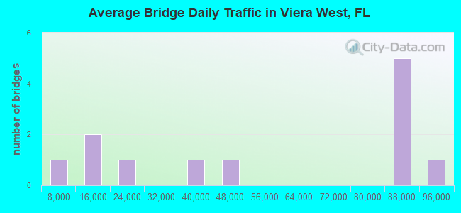
- 625,900Total average daily traffic
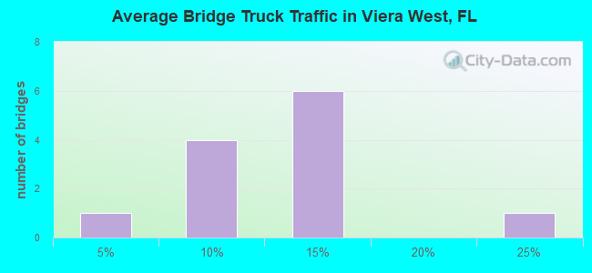
- 65,159Total average daily truck traffic
- National Bridge Inventory (NBI) Registered Bridges for Viera West
- No street view available for this location
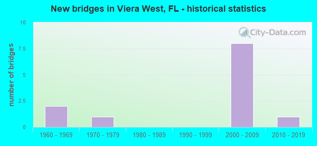
- New bridges - historical statistics
- 21960-1969
- 11970-1979
- 82000-2009
- 12010-2019
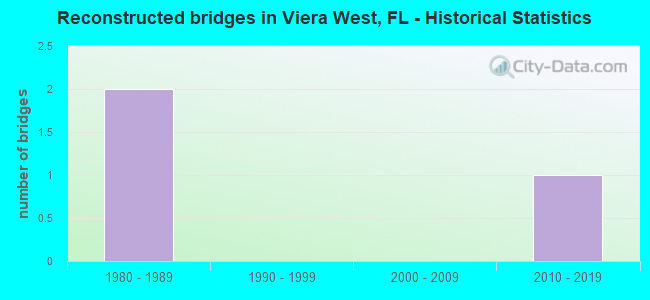
- Reconstructed bridges - Historical Statistics
- 21980-1989
- 01990-1999
- 02000-2009
- 12010-2019
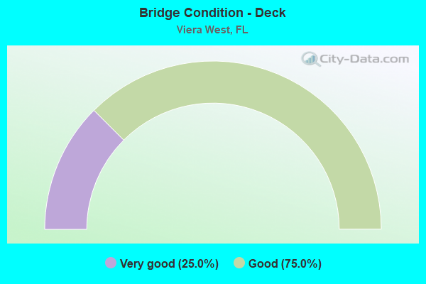
- Bridge Condition - Deck
- 25.0%Very good
- 75.0%Good

- Bridge Condition - Superstructure
- 75.0%Very good
- 25.0%Good
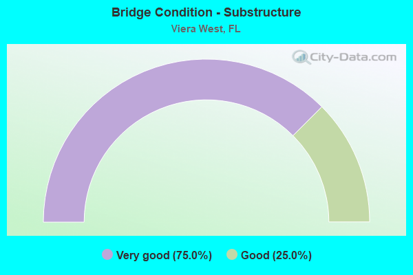
- Bridge Condition - Substructure
- 75.0%Very good
- 25.0%Good
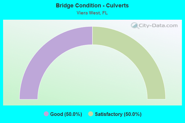
- Bridge Condition - Culverts
- 50.0%Good
- 50.0%Satisfactory
Find on map >> Show street view
Structure Number: 700163, Location: 1.5 MI S of Wickham Rd (Lat: 28.209081, Lng: -80.712353), Route carried "on" structure: Interstate 95, Year Built: 1965, Year Reconstructed: 1980, Status: Open, Structure Length: 0.63m (2.07ft), Average Daily Traffic: 83,000 (year 2020), Truck Traffic: 10%, Average Future Daily Traffic: 144,005 (year 2042), Design Load: HS 20+Mod, Features Intersected: Brushy Canal
Minimum Vertical Clearance: 30+ m (98+ ft), Kilometerpoint: 47.810, Lanes on structure: 6, Base Highway Network: Yes, Owner: State Highway Agency, Approaching Roadway Width: 34.1m (111.9ft), Skew: 10 degrees, Material/Design: Concrete, Design/Construction: Culvert, Number Of Spans In Main Unit: 2, Length of Maximum Span: 3.0m (9.8ft)
Condition: Channel: Good, Culverts: Satisfactory, Operating Rating: 83.5 metric tons, Method Used To Determine Operating Rating: Load Factor (LF), Inventory Rating: 50.1 metric tons, Method Used To Determine Inventory Rating: Load Factor (LF), Structural Evaluation: Equal to present minimum criteria, Waterway Adequacy: Equal to present desirable criteria, Approach Roadway Alignment: Equal to present desirable criteria, Designated Inspection Frequency: Every 24 months, Inspection Date: January 2021
Find on map >> Show street view
Structure Number: 700164, Location: 1.2 Mi S of Wickham R. (Lat: 28.212294, Lng: -80.713292), Route carried "on" structure: Interstate 95, Year Built: 1965, Year Reconstructed: 1980, Status: Open, Structure Length: 0.63m (2.07ft), Average Daily Traffic: 83,000 (year 2020), Truck Traffic: 10%, Average Future Daily Traffic: 144,005 (year 2042), Design Load: HS 20+Mod, Features Intersected: Palm Canal
Minimum Vertical Clearance: 30+ m (98+ ft), Kilometerpoint: 48.181, Lanes on structure: 6, Base Highway Network: Yes, Owner: State Highway Agency, Approaching Roadway Width: 34.1m (111.9ft), Skew: 10 degrees, Material/Design: Concrete, Design/Construction: Culvert, Number Of Spans In Main Unit: 2, Length of Maximum Span: 3.0m (9.8ft)
Condition: Channel: Good, Culverts: Satisfactory, Operating Rating: 83.5 metric tons, Method Used To Determine Operating Rating: Load Factor (LF), Inventory Rating: 50.1 metric tons, Method Used To Determine Inventory Rating: Load Factor (LF), Structural Evaluation: Equal to present minimum criteria, Waterway Adequacy: Equal to present desirable criteria, Approach Roadway Alignment: Equal to present desirable criteria, Designated Inspection Frequency: Every 24 months, Inspection Date: January 2021
Find on map >> Show street view
Structure Number: 70018, Location: I-95 SB Fiske Blvd Ramp (Lat: 28.289250, Lng: -80.742008), Route carried "on" structure: Ramp Interstate 95, Year Built: 1971, Status: Open, Structure Length: 0.70m (2.30ft), Average Daily Traffic: 7,500 (year 2020), Truck Traffic: 10%, Average Future Daily Traffic: 13,012 (year 2042), Design Load: HS 20+Mod, Features Intersected: Canal, Facility Carried by Structure: Fiske Blvd Ramps
Minimum Vertical Clearance: 30+ m (98+ ft), Kilometerpoint: 0.058, Lanes on structure: 2, Base Highway Network: Yes, Owner: State Highway Agency, Approaching Roadway Width: 8.5m (27.9ft), Skew: 10 degrees, Material/Design: Concrete, Design/Construction: Culvert, Number Of Spans In Main Unit: 2, Length of Maximum Span: 3.4m (11.2ft)
Condition: Channel: Good, Culverts: Good, Operating Rating: 67.7 metric tons, Method Used To Determine Operating Rating: Load Factor (LF), Inventory Rating: 40.6 metric tons, Method Used To Determine Inventory Rating: Load Factor (LF), Structural Evaluation: Better than present minimum criteria, Waterway Adequacy: Equal to present desirable criteria, Approach Roadway Alignment: Equal to present desirable criteria, Designated Inspection Frequency: Every 24 months, Underwater Inspection Frequency: Every 24 months, Inspection Date: April 2021, Underwater Inspection Date: April 2021
Find on map >> Show street view
Structure Number: 700222, Location: I-95 over Wickham Road (Lat: 28.230278, Lng: -80.718611), Route carried "on" structure: Interstate 95, Year Built: 2009, Status: Open, Structure Length: 5.43m (17.81ft), Average Daily Traffic: 83,000 (year 2020), Truck Traffic: 10%, Average Future Daily Traffic: 144,005 (year 2042), Design Load: HL 93, Features Intersected: Wickham Road
Minimum Vertical Clearance: 30+ m (98+ ft), Kilometerpoint: 50.192, Lanes on structure: 6, Lanes under structure: 6, Base Highway Network: Yes, Owner: State Highway Agency, Approaching Roadway Width: 39.6m (129.9ft), Skew: 31 degrees, Material/Design: Prestressed concrete, Design/Construction: Stringer/Multi-beam, Number Of Spans In Main Unit: 2, Length of Maximum Span: 26.8m (87.9ft), Curb-To-Curb Width: 39.6m (129.9ft), Out-to-Out Width: 41.2m (135.2ft)
Condition: Deck: Very good, Superstructure: Very good, Substructure: Very good, Operating Rating: 39.5 metric tons, Method Used To Determine Operating Rating: Load and Resistance Factor (LRFR), Inventory Rating: 35.9 metric tons, Method Used To Determine Inventory Rating: Load and Resistance Factor (LRFR), Structural Evaluation: Equal to present desirable criteria, Deck Geometry: Superior to present desirable criteria, Underclear: Equal to present minimum criteria, Approach Roadway Alignment: Equal to present desirable criteria, Designated Inspection Frequency: Every 24 months, Inspection Date: October 2021, Deck Structure Type: Concrete Cast-file-Place
Find on map >> Show street view
Structure Number: 700225, Location: 2.6 MI S of Wickham Rd. (Lat: 28.192439, Lng: -80.707564), Route carried "on" structure: State highway 404, Year Built: 2009, Status: Open, Structure Length: 6.34m (20.80ft), Average Daily Traffic: 32,500 (year 2020), Truck Traffic: 5%, Average Future Daily Traffic: 56,388 (year 2042), Design Load: HL 93, Features Intersected: I-95, Facility Carried by Structure: Pineda Causeway
Minimum Vertical Clearance: 30+ m (98+ ft), Kilometerpoint: 0.341, Lanes on structure: 6, Lanes under structure: 6, Owner: State Highway Agency, Approaching Roadway Width: 28.7m (94.2ft), Skew: 20 degrees, Material/Design: Prestressed concrete, Design/Construction: Stringer/Multi-beam, Number Of Spans In Main Unit: 2, Length of Maximum Span: 31.7m (104.0ft), Curb or Sidewalk Widths: Left: 1.8m (5.9ft), Right: 1.8m (5.9ft), Curb-To-Curb Width: 28.7m (94.2ft), Out-to-Out Width: 34.7m (113.8ft)
Condition: Deck: Good, Superstructure: Good, Substructure: Good, Operating Rating: 36.8 metric tons, Method Used To Determine Operating Rating: Load and Resistance Factor (LRFR), Inventory Rating: 33.3 metric tons, Method Used To Determine Inventory Rating: Load and Resistance Factor (LRFR), Structural Evaluation: Better than present minimum criteria, Deck Geometry: Superior to present desirable criteria, Underclear: Equal to present minimum criteria, Approach Roadway Alignment: Better than present minimum criteria, Designated Inspection Frequency: Every 24 months, Inspection Date: June 2021, Deck Structure Type: Concrete Cast-file-Place
Find on map >> Show street view
Structure Number: 700226, Location: .1 Mi E of I-95 (Lat: 28.192778, Lng: -80.706108), Route carried "on" structure: State highway 404, Year Built: 2011, Status: Open, Structure Length: 0.98m (3.22ft), Average Daily Traffic: 18,500 (year 2015), Truck Traffic: 2%, Average Future Daily Traffic: 27,884 (year 2035), Design Load: HL 93, Features Intersected: Zoo Trail, Facility Carried by Structure: Pineda Causeway
Minimum Vertical Clearance: 30+ m (98+ ft), Kilometerpoint: 0.161, Lanes on structure: 5, Owner: State Highway Agency, Maintenance Responsibility: County Highway Agency, Approaching Roadway Width: 25.1m (82.3ft), Skew: 10 degrees, Material/Design: Concrete, Design/Construction: Culvert, Number Of Spans In Main Unit: 1, Length of Maximum Span: 9.8m (32.2ft), Curb or Sidewalk Widths: Left: 1.5m (4.9ft), Right: 1.5m (4.9ft)
Condition: Culverts: Good, Operating Rating: 52.3 metric tons, Method Used To Determine Operating Rating: Load and Resistance Factor (LRFR), Inventory Rating: 39.2 metric tons, Method Used To Determine Inventory Rating: Load and Resistance Factor (LRFR), Structural Evaluation: Better than present minimum criteria, Approach Roadway Alignment: Equal to present desirable criteria, Designated Inspection Frequency: Every 24 months, Inspection Date: October 2021
Find on map >> Show street view
Structure Number: 704097, Location: Viera Blvd WB over I-95 (Lat: 28.266667, Lng: -80.729056), Route carried "on" structure: County highway , Year Built: 2007, Status: Open, Structure Length: 6.23m (20.44ft), Average Daily Traffic: 8,450 (year 2020), Truck Traffic: 5%, Average Future Daily Traffic: 14,661 (year 2042), Design Load: HS 20, Features Intersected: I-95, Facility Carried by Structure: Viera Blvd EB
Minimum Vertical Clearance: 30+ m (98+ ft), Kilometerpoint: 0.711, Lanes on structure: 2, Lanes under structure: 6, Owner: County Highway Agency, Approaching Roadway Width: 11.2m (36.7ft), Skew: 1 degrees, Material/Design: Prestressed concrete, Design/Construction: Stringer/Multi-beam, Number Of Spans In Main Unit: 2, Length of Maximum Span: 30.8m (101.0ft), Curb or Sidewalk Widths: Left: 2.4m (7.9ft), Right: 0.0m, Curb-To-Curb Width: 11.2m (36.7ft), Out-to-Out Width: 14.8m (48.6ft)
Condition: Deck: Good, Superstructure: Very good, Substructure: Very good, Operating Rating: 50.6 metric tons, Method Used To Determine Operating Rating: Load and Resistance Factor (LRFR), Inventory Rating: 38.8 metric tons, Method Used To Determine Inventory Rating: Load and Resistance Factor (LRFR), Structural Evaluation: Equal to present desirable criteria, Deck Geometry: Equal to present minimum criteria, Underclear: Somewhat better than minimum adequacy, Approach Roadway Alignment: Equal to present desirable criteria, Designated Inspection Frequency: Every 24 months, Inspection Date: October 2021, Deck Structure Type: Concrete Cast-file-Place
Find on map >> Show street view
Structure Number: 704098, Location: Viera Blvd WB over I-95 (Lat: 28.266500, Lng: -80.729000), Route carried "on" structure: County highway , Year Built: 2007, Year Reconstructed: 2019, Status: Open, Structure Length: 6.23m (20.44ft), Average Daily Traffic: 8,450 (year 2020), Truck Traffic: 5%, Average Future Daily Traffic: 14,661 (year 2042), Design Load: HS 20, Features Intersected: I-95, Facility Carried by Structure: Viera Blvd WB
Minimum Vertical Clearance: 30+ m (98+ ft), Kilometerpoint: 0.711, Lanes on structure: 2, Lanes under structure: 6, Owner: County Highway Agency, Approaching Roadway Width: 11.2m (36.7ft), Skew: 1 degrees, Material/Design: Prestressed concrete, Design/Construction: Stringer/Multi-beam, Number Of Spans In Main Unit: 2, Length of Maximum Span: 30.8m (101.0ft), Curb or Sidewalk Widths: Left: 0.0m, Right: 2.4m (7.9ft), Curb-To-Curb Width: 11.2m (36.7ft), Out-to-Out Width: 14.8m (48.6ft)
Condition: Deck: Good, Superstructure: Very good, Substructure: Very good, Operating Rating: 50.6 metric tons, Method Used To Determine Operating Rating: Load and Resistance Factor (LRFR), Inventory Rating: 38.8 metric tons, Method Used To Determine Inventory Rating: Load and Resistance Factor (LRFR), Structural Evaluation: Equal to present desirable criteria, Deck Geometry: Equal to present minimum criteria, Underclear: Equal to present minimum criteria, Approach Roadway Alignment: Equal to present desirable criteria, Designated Inspection Frequency: Every 24 months, Inspection Date: October 2021, Deck Structure Type: Concrete Cast-file-Place
Find on map >> Show street view
Structure Number: 700222, Location: I-95 over Wickham Road (Lat: 28.230278, Lng: -80.718611), Route carried "under" structure: County highway 509, Year Built: 2009, Structure Length: 0. m, Average Daily Traffic: 44,500 (year 2020), Truck Traffic: 6%, Features Intersected: Wickham Road, Facility Carried by Structure: I-95
Minimum Vertical Clearance: 5.61m (18.41ft), Kilometerpoint: 0.246, Lanes on structure: 6, Lanes under structure: 6, Material/Design: Prestressed concrete, Design/Construction: Stringer/Multi-beam, Length of Maximum Span: 26.8m (87.9ft)
Find on map >> Show street view
Structure Number: 700225, Location: 2.6 MI S of Wickham Rd. (Lat: 28.192439, Lng: -80.707564), Route carried "under" structure: Interstate 95, Year Built: 2009, Structure Length: 0. m, Average Daily Traffic: 91,000 (year 2020), Truck Traffic: 10%, Features Intersected: I-95, Facility Carried by Structure: Pineda Causeway
Minimum Vertical Clearance: 5.27m (17.29ft), Kilometerpoint: 46.032, Lanes on structure: 6, Lanes under structure: 6, Material/Design: Prestressed concrete, Design/Construction: Stringer/Multi-beam, Length of Maximum Span: 31.7m (104.0ft)
Find on map >> Show street view
Structure Number: 704097, Location: Viera Blvd WB over I-95 (Lat: 28.266667, Lng: -80.729056), Route carried "under" structure: Interstate 95, Year Built: 2007, Structure Length: 0. m, Average Daily Traffic: 83,000 (year 2020), Truck Traffic: 20%, Features Intersected: I-95, Facility Carried by Structure: Viera Blvd EB
Minimum Vertical Clearance: 5.09m (16.70ft), Kilometerpoint: 54.388, Lanes on structure: 2, Lanes under structure: 6, Material/Design: Prestressed concrete, Design/Construction: Stringer/Multi-beam, Length of Maximum Span: 30.8m (101.0ft)
Find on map >> Show street view
Structure Number: 704098, Location: Viera Blvd WB over I-95 (Lat: 28.266500, Lng: -80.729000), Route carried "under" structure: Interstate 95, Year Built: 2007, Structure Length: 0. m, Average Daily Traffic: 83,000 (year 2020), Truck Traffic: 10%, Features Intersected: I-95, Facility Carried by Structure: Viera Blvd WB
Minimum Vertical Clearance: 5.09m (16.70ft), Kilometerpoint: 54.364, Lanes on structure: 2, Lanes under structure: 6, Material/Design: Prestressed concrete, Design/Construction: Stringer/Multi-beam, Length of Maximum Span: 30.8m (101.0ft)