Bridge Statistics for Village of Clarkston, Michigan (MI)
Condition, Traffic, Stress, Structural Evaluation, Project Costs
- National Bridge Inventory (NBI) Statistics
- 20Number of bridges
- 167ft / 51.3mTotal length
- $1,306,000Total costs
- 616,528Total average daily traffic
- 33,910Total average daily truck traffic
- National Bridge Inventory (NBI) Registered Bridges for Village of Clarkston
- No street view available for this location
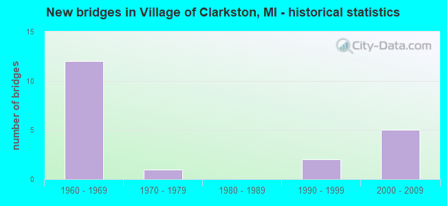
- New bridges - historical statistics
- 121960-1969
- 11970-1979
- 21990-1999
- 52000-2009


- Bridge Condition - Deck
- 22.2%Good
- 55.6%Satisfactory
- 22.2%Fair

- Bridge Condition - Superstructure
- 22.2%Very good
- 44.4%Good
- 33.3%Satisfactory

- Bridge Condition - Substructure
- 11.1%Very good
- 44.4%Good
- 33.3%Satisfactory
- 11.1%Fair

- Bridge Condition - Channel
- 60.0%Good
- 20.0%Satisfactory
- 20.0%Poor

- Bridge Condition - Culverts
- 33.3%Very good
- 33.3%Satisfactory
- 33.3%Poor
Find on map >> Show street view
Structure Number: 8019, Location: 2.2 MI SE OF M-15 (Lat: 42.736158, Lng: -83.379631), Route carried "on" structure: County highway 2059, Year Built: 1962, Status: Open, Structure Length: 11.18m (36.68ft), Average Daily Traffic: 13,460 (year 1987), Truck Traffic: 3%, Design Load: H 20, Features Intersected: I-75, Facility Carried by Structure: SASHABAW RD
Minimum Vertical Clearance: 30.48m (100.00ft), Kilometerpoint: 6.487, Lanes on structure: 4, Lanes under structure: 4, Owner: State Highway Agency, Approaching Roadway Width: 18.2m (59.7ft), Skew: 4 degrees, Material/Design: Steel, Design/Construction: Stringer/Multi-beam, Number Of Spans In Main Unit: 4, Length of Maximum Span: 33.8m (110.9ft), Curb or Sidewalk Widths: Left: 2.4m (7.9ft), Right: 0.0m, Curb-To-Curb Width: 16.0m (52.5ft), Out-to-Out Width: 19.7m (64.6ft)
Condition: Deck: Satisfactory, Superstructure: Good, Substructure: Satisfactory, Operating Rating: 72.3 metric tons, Method Used To Determine Operating Rating: Load Factor (LF), Inventory Rating: 43.3 metric tons, Method Used To Determine Inventory Rating: Load Factor (LF), Structural Evaluation: Equal to present minimum criteria, Deck Geometry: Meets minimum limits, Underclear: High priority of corrective action, Approach Roadway Alignment: Equal to present desirable criteria, Designated Inspection Frequency: Every 24 months, Inspection Date: March 2021, Bridge Improvement Cost: $384,000, Deck Structure Type: Concrete Cast-file-Place, Wearing Surface/Protective System: Wearing Surface: Latex Concrete
Find on map >> Show street view
Structure Number: 802, Location: 1.1 MI SE OF M-15 (Lat: 42.745222, Lng: -83.399769), Route carried "on" structure: Interstate 75, Year Built: 1962, Year Reconstructed: 1988, Status: Open, Structure Length: 3.44m (11.29ft), Average Daily Traffic: 35,763 (year 2007), Truck Traffic: 5%, Average Future Daily Traffic: 55,750 (year 2029), Design Load: HS 20+Mod, Features Intersected: CLARKSTON RD
Minimum Vertical Clearance: 30.48m (100.00ft), Kilometerpoint: 49.917, Lanes on structure: 3, Lanes under structure: 2, Base Highway Network: Yes (Inventory Route: 64, Subroute: 6), Owner: State Highway Agency, Approaching Roadway Width: 17.0m (55.8ft), Skew: 1 degrees, Material/Design: Steel, Design/Construction: Stringer/Multi-beam, Number Of Spans In Main Unit: 3, Length of Maximum Span: 12.7m (41.7ft), Curb-To-Curb Width: 18.0m (59.1ft), Out-to-Out Width: 18.9m (62.0ft)
Condition: Deck: Fair, Superstructure: Satisfactory, Substructure: Good, Operating Rating: 78.8 metric tons, Method Used To Determine Operating Rating: Load Factor (LF), Inventory Rating: 47.2 metric tons, Method Used To Determine Inventory Rating: Load Factor (LF), Structural Evaluation: Equal to present minimum criteria, Deck Geometry: Better than present minimum criteria, Underclear: High priority of corrective action, Approach Roadway Alignment: Equal to present desirable criteria, Designated Inspection Frequency: Every 24 months, Inspection Date: March 2021, Deck Structure Type: Concrete Cast-file-Place, Wearing Surface/Protective System: Wearing Surface: Epoxy Overlay, Deck Protection: Epoxy Coated Reinforcing
Find on map >> Show street view
Structure Number: 8021, Location: 1.1 MI SE OF M-15 (Lat: 42.745681, Lng: -83.399797), Route carried "on" structure: Interstate 75, Year Built: 1962, Year Reconstructed: 1988, Status: Open, Structure Length: 3.33m (10.93ft), Average Daily Traffic: 35,763 (year 2007), Truck Traffic: 5%, Average Future Daily Traffic: 48,200 (year 2029), Design Load: HS 20+Mod, Features Intersected: CLARKSTON RD
Minimum Vertical Clearance: 30.48m (100.00ft), Kilometerpoint: 49.883, Lanes on structure: 3, Lanes under structure: 2, Base Highway Network: Yes (Inventory Route: 64, Subroute: 8), Owner: State Highway Agency, Approaching Roadway Width: 17.0m (55.8ft), Material/Design: Steel, Design/Construction: Stringer/Multi-beam, Number Of Spans In Main Unit: 3, Length of Maximum Span: 12.4m (40.7ft), Curb-To-Curb Width: 18.0m (59.1ft), Out-to-Out Width: 18.9m (62.0ft)
Condition: Deck: Fair, Superstructure: Satisfactory, Substructure: Satisfactory, Operating Rating: 78.7 metric tons, Method Used To Determine Operating Rating: Load Factor (LF), Inventory Rating: 47.1 metric tons, Method Used To Determine Inventory Rating: Load Factor (LF), Structural Evaluation: Equal to present minimum criteria, Deck Geometry: Better than present minimum criteria, Underclear: High priority of corrective action, Approach Roadway Alignment: Equal to present desirable criteria, Designated Inspection Frequency: Every 24 months, Inspection Date: March 2021, Deck Structure Type: Concrete Cast-file-Place, Wearing Surface/Protective System: Wearing Surface: Epoxy Overlay, Deck Protection: Epoxy Coated Reinforcing
Find on map >> Show street view
Structure Number: 8022, Location: @ M-15 (Lat: 42.746400, Lng: -83.419517), Route carried "on" structure: State highway 15, Year Built: 2005, Status: Open, Structure Length: 6.00m (19.69ft), Average Daily Traffic: 22,892 (year 2007), Truck Traffic: 2%, Average Future Daily Traffic: 32,720 (year 2018), Design Load: HS 25 or greater, Features Intersected: I-75
Minimum Vertical Clearance: 30.48m (100.00ft), Kilometerpoint: 2.903, Lanes on structure: 4, Lanes under structure: 8, Base Highway Network: Yes (Inventory Route: 62, Subroute: 9), Owner: State Highway Agency, Approaching Roadway Width: 21.9m (71.9ft), Skew: 20 degrees, Material/Design: Prestressed concrete, Design/Construction: Box Beam or Girders - Multiple, Number Of Spans In Main Unit: 2, Length of Maximum Span: 29.9m (98.1ft), Curb or Sidewalk Widths: Left: 0.0m, Right: 4.4m (14.4ft), Curb-To-Curb Width: 21.9m (71.9ft), Out-to-Out Width: 27.7m (90.9ft)
Condition: Deck: Good, Superstructure: Very good, Substructure: Satisfactory, Operating Rating: 95.9 metric tons, Method Used To Determine Operating Rating: Load Factor (LF) rating reported by rating factor (RF) method using MS18 loading, Inventory Rating: 50.2 metric tons, Method Used To Determine Inventory Rating: Load Factor (LF) rating reported by rating factor (RF) method using MS18 loading, Structural Evaluation: Equal to present minimum criteria, Deck Geometry: Superior to present desirable criteria, Underclear: Somewhat better than minimum adequacy, Approach Roadway Alignment: Equal to present desirable criteria, Designated Inspection Frequency: Every 24 months, Inspection Date: March 2021, Deck Structure Type: Concrete Cast-file-Place, Wearing Surface/Protective System: Wearing Surface: Monolithic Concrete, Deck Protection: Epoxy Coated Reinforcing
Find on map >> Show street view
Structure Number: 803, Location: 1.4 MI W OF M-15 (Lat: 42.742006, Lng: -83.445869), Route carried "on" structure: Interstate 75, Year Built: 1962, Status: Open, Structure Length: 0.76m (2.49ft), Average Daily Traffic: 56,522 (year 2007), Truck Traffic: 7%, Average Future Daily Traffic: 71,851 (year 2018), Design Load: HS 20+Mod, Features Intersected: DEERLAKE CREEK
Minimum Vertical Clearance: 30.48m (100.00ft), Kilometerpoint: 53.812, Lanes on structure: 6, Base Highway Network: Yes (Inventory Route: 64, Subroute: 8), Owner: State Highway Agency, Approaching Roadway Width: 16.4m (53.8ft), Material/Design: Concrete, Design/Construction: Culvert, Number Of Spans In Main Unit: 2, Length of Maximum Span: 3.6m (11.8ft), Curb-To-Curb Width: 47.4m (155.5ft), Out-to-Out Width: 96.3m (315.9ft)
Condition: Channel: Good, Culverts: Satisfactory, Operating Rating: 97.2 metric tons, Method Used To Determine Operating Rating: Load Factor (LF) rating reported by rating factor (RF) method using MS18 loading, Inventory Rating: 97.2 metric tons, Method Used To Determine Inventory Rating: Load Factor (LF) rating reported by rating factor (RF) method using MS18 loading, Structural Evaluation: Equal to present minimum criteria, Deck Geometry: Superior to present desirable criteria, Waterway Adequacy: Better than present minimum criteria, Approach Roadway Alignment: Equal to present desirable criteria, Designated Inspection Frequency: Every 24 months, Inspection Date: December 2020, Deck Structure Type: Concrete Cast-file-Place, Wearing Surface/Protective System: Wearing Surface: Bituminous, Membrane: Other
Find on map >> Show street view
Structure Number: 8031, Location: 0.7 MI W OF M-15 (Lat: 42.746842, Lng: -83.432558), Route carried "on" structure: County highway 2059, Year Built: 1962, Status: Open, Structure Length: 11.47m (37.63ft), Average Daily Traffic: 1,680 (year 1974), Average Future Daily Traffic: 1,680 (year 1977), Design Load: H 15, Features Intersected: I-75, Facility Carried by Structure: HOLCOMB RD
Minimum Vertical Clearance: 30.48m (100.00ft), Kilometerpoint: 2.686, Lanes on structure: 2, Lanes under structure: 6, Owner: State Highway Agency, Approaching Roadway Width: 9.7m (31.8ft), Skew: 4 degrees, Material/Design: Steel, Design/Construction: Stringer/Multi-beam, Number Of Spans In Main Unit: 4, Length of Maximum Span: 33.1m (108.6ft), Curb-To-Curb Width: 8.4m (27.6ft), Out-to-Out Width: 9.4m (30.8ft)
Condition: Deck: Satisfactory, Superstructure: Satisfactory, Substructure: Good, Operating Rating: 64.2 metric tons, Method Used To Determine Operating Rating: Load Factor (LF) rating reported by rating factor (RF) method using MS18 loading, Inventory Rating: 38.2 metric tons, Method Used To Determine Inventory Rating: Load Factor (LF) rating reported by rating factor (RF) method using MS18 loading, Structural Evaluation: Equal to present minimum criteria, Deck Geometry: Meets minimum limits, Underclear: High priority of corrective action, Approach Roadway Alignment: Equal to present desirable criteria, Length Of Structure Improvement: 11.46m (37.60ft), Designated Inspection Frequency: Every 24 months, Inspection Date: July 2021, Bridge Improvement Cost: $1,106,000, Roadway Improvement Cost: $97,000, Total Project Cost: $1,145,000, Deck Structure Type: Concrete Cast-file-Place, Wearing Surface/Protective System: Wearing Surface: Latex Concrete
Find on map >> Show street view
Structure Number: 8032, Location: @ US-24 (Lat: 42.738961, Lng: -83.451606), Route carried "on" structure: US 24, Year Built: 2004, Status: Open, Structure Length: 5.61m (18.41ft), Average Daily Traffic: 26,557 (year 2007), Truck Traffic: 4%, Average Future Daily Traffic: 39,813 (year 2018), Design Load: HS 25 or greater, Features Intersected: I-75 SB
Minimum Vertical Clearance: 30.48m (100.00ft), Kilometerpoint: 0.552, Lanes on structure: 5, Lanes under structure: 4, Base Highway Network: Yes (Inventory Route: 68, Subroute: 3), Owner: State Highway Agency, Approaching Roadway Width: 24.4m (80.1ft), Material/Design: Prestressed concrete, Design/Construction: Box Beam or Girders - Multiple, Number Of Spans In Main Unit: 3, Length of Maximum Span: 21.6m (70.9ft), Curb-To-Curb Width: 25.6m (84.0ft), Out-to-Out Width: 26.6m (87.3ft)
Condition: Deck: Good, Superstructure: Very good, Substructure: Good, Operating Rating: 97.2 metric tons, Method Used To Determine Operating Rating: Load Factor (LF) rating reported by rating factor (RF) method using MS18 loading, Inventory Rating: 59.0 metric tons, Method Used To Determine Inventory Rating: Load Factor (LF) rating reported by rating factor (RF) method using MS18 loading, Structural Evaluation: Better than present minimum criteria, Deck Geometry: Superior to present desirable criteria, Underclear: Meets minimum limits, Approach Roadway Alignment: Equal to present desirable criteria, Designated Inspection Frequency: Every 24 months, Inspection Date: December 2020, Deck Structure Type: Concrete Cast-file-Place, Wearing Surface/Protective System: Wearing Surface: Monolithic Concrete, Deck Protection: Epoxy Coated Reinforcing
Find on map >> Show street view
Structure Number: 8033, Location: @ US-24 (Lat: 42.740514, Lng: -83.453636), Route carried "on" structure: Interstate 75, Year Built: 1962, Status: Open, Structure Length: 6.00m (19.69ft), Average Daily Traffic: 28,261 (year 2007), Truck Traffic: 10%, Average Future Daily Traffic: 27,609 (year 2018), Design Load: HS 20+Mod, Features Intersected: US-24
Minimum Vertical Clearance: 30.48m (100.00ft), Kilometerpoint: 54.465, Lanes on structure: 4, Lanes under structure: 5, Base Highway Network: Yes (Inventory Route: 64, Subroute: 8), Owner: State Highway Agency, Approaching Roadway Width: 20.1m (65.9ft), Skew: 3 degrees, Material/Design: Steel, Design/Construction: Stringer/Multi-beam, Number Of Spans In Main Unit: 3, Length of Maximum Span: 32.6m (107.0ft), Curb or Sidewalk Widths: Left: 0.4m (1.3ft), Right: 0.4m (1.3ft), Curb-To-Curb Width: 18.2m (59.7ft), Out-to-Out Width: 19.8m (65.0ft)
Condition: Deck: Satisfactory, Superstructure: Good, Substructure: Fair, Operating Rating: 55.1 metric tons, Method Used To Determine Operating Rating: Load Factor (LF) rating reported by rating factor (RF) method using MS18 loading, Inventory Rating: 33.0 metric tons, Method Used To Determine Inventory Rating: Load Factor (LF) rating reported by rating factor (RF) method using MS18 loading, Structural Evaluation: Somewhat better than minimum adequacy, Deck Geometry: Meets minimum limits, Underclear: Meets minimum limits, Approach Roadway Alignment: Equal to present desirable criteria, Length Of Structure Improvement: 6.01m (19.72ft), Designated Inspection Frequency: Every 24 months, Other Special Inspection Frequency: Every 3 months, Inspection Date: December 2020, Other Special Inspection Date: January 2022, Bridge Improvement Cost: $267,000, Roadway Improvement Cost: $14,000, Total Project Cost: $161,000, Deck Structure Type: Concrete Cast-file-Place, Wearing Surface/Protective System: Wearing Surface: Latex Concrete
Find on map >> Show street view
Structure Number: 8185, Location: BET AIRPORT AND CLEMENT R (Lat: 42.706656, Lng: -83.427703), Route carried "on" structure: County highway 2059, Year Built: 1990, Status: Open, Structure Length: 0.85m (2.79ft), Average Daily Traffic: 6,250 (year 2015), Average Future Daily Traffic: 6,500 (year 2035), Design Load: HS 20, Features Intersected: CLINTON RIVER, Facility Carried by Structure: ANDERSONVILLE RD
Minimum Vertical Clearance: 30.48m (100.00ft), Kilometerpoint: 1.410, Lanes on structure: 2, Owner: County Highway Agency, Approaching Roadway Width: 11.0m (36.1ft), Material/Design: Prestressed concrete, Design/Construction: Box Beam or Girders - Multiple, Number Of Spans In Main Unit: 1, Length of Maximum Span: 7.3m (24.0ft), Curb-To-Curb Width: 14.0m (45.9ft), Out-to-Out Width: 15.2m (49.9ft)
Condition: Deck: Satisfactory, Superstructure: Good, Substructure: Very good, Channel: Good, Operating Rating: 97.2 metric tons, Method Used To Determine Operating Rating: Load Factor (LF) rating reported by rating factor (RF) method using MS18 loading, Inventory Rating: 70.0 metric tons, Method Used To Determine Inventory Rating: Load Factor (LF) rating reported by rating factor (RF) method using MS18 loading, Structural Evaluation: Better than present minimum criteria, Deck Geometry: Superior to present desirable criteria, Waterway Adequacy: Equal to present desirable criteria, Approach Roadway Alignment: Equal to present minimum criteria, Designated Inspection Frequency: Every 24 months, Inspection Date: July 2020, Deck Structure Type: Concrete Cast-file-Place, Wearing Surface/Protective System: Wearing Surface: Monolithic Concrete, Deck Protection: Epoxy Coated Reinforcing
Find on map >> Show street view
Structure Number: 8186, Location: BET AIRPORT AND CLEMENT R (Lat: 42.704308, Lng: -83.419664), Route carried "on" structure: County highway 2059, Year Built: 1990, Status: Open, Structure Length: 0.85m (2.79ft), Average Daily Traffic: 6,250 (year 2015), Average Future Daily Traffic: 6,500 (year 2035), Design Load: HS 20, Features Intersected: CLINTON RIVER, Facility Carried by Structure: ANDERSONVILLE RD
Minimum Vertical Clearance: 30.48m (100.00ft), Kilometerpoint: 2.120, Lanes on structure: 2, Owner: County Highway Agency, Approaching Roadway Width: 11.0m (36.1ft), Material/Design: Prestressed concrete, Design/Construction: Box Beam or Girders - Multiple, Number Of Spans In Main Unit: 1, Length of Maximum Span: 7.3m (24.0ft), Curb-To-Curb Width: 14.0m (45.9ft), Out-to-Out Width: 15.2m (49.9ft)
Condition: Deck: Satisfactory, Superstructure: Good, Substructure: Good, Channel: Satisfactory, Operating Rating: 97.2 metric tons, Method Used To Determine Operating Rating: Load Factor (LF) rating reported by rating factor (RF) method using MS18 loading, Inventory Rating: 70.0 metric tons, Method Used To Determine Inventory Rating: Load Factor (LF) rating reported by rating factor (RF) method using MS18 loading, Structural Evaluation: Better than present minimum criteria, Deck Geometry: Superior to present desirable criteria, Waterway Adequacy: Superior to present desirable criteria, Approach Roadway Alignment: Equal to present minimum criteria, Designated Inspection Frequency: Every 24 months, Inspection Date: July 2020, Deck Structure Type: Concrete Cast-file-Place, Wearing Surface/Protective System: Wearing Surface: Monolithic Concrete, Deck Protection: Epoxy Coated Reinforcing
Find on map >> Show street view
Structure Number: 1325, Location: INDEPENDENCE TWP SEC 20 (Lat: 42.744319, Lng: -83.419442), Route carried "on" structure: State highway 15, Year Built: 2005, Status: Open, Structure Length: 0.66m (2.17ft), Average Daily Traffic: 16,486 (year 2007), Truck Traffic: 3%, Average Future Daily Traffic: 23,460 (year 2024), Design Load: HS 25 or greater, Features Intersected: CLINTON RIVER
Minimum Vertical Clearance: 30.48m (100.00ft), Kilometerpoint: 2.649, Lanes on structure: 5, Base Highway Network: Yes (Inventory Route: 62, Subroute: 9), Owner: State Highway Agency, Approaching Roadway Width: 26.5m (86.9ft), Material/Design: Concrete, Design/Construction: Culvert, Number Of Spans In Main Unit: 1, Length of Maximum Span: 6.1m (20.0ft), Curb-To-Curb Width: 27.9m (91.5ft), Out-to-Out Width: 34.1m (111.9ft)
Condition: Channel: Good, Culverts: Very good, Operating Rating: 69.3 metric tons, Method Used To Determine Operating Rating: Load Factor (LF) rating reported by rating factor (RF) method using MS18 loading, Inventory Rating: 41.5 metric tons, Method Used To Determine Inventory Rating: Load Factor (LF) rating reported by rating factor (RF) method using MS18 loading, Structural Evaluation: Equal to present desirable criteria, Deck Geometry: Superior to present desirable criteria, Waterway Adequacy: Equal to present minimum criteria, Approach Roadway Alignment: Equal to present minimum criteria, Designated Inspection Frequency: Every 24 months, Inspection Date: July 2021, Deck Structure Type: Concrete Cast-file-Place, Wearing Surface/Protective System: Wearing Surface: Latex Concrete
Find on map >> Show street view
Structure Number: 14031, Location: 0.2 MI SE I-75&DIXIE HWY (Lat: 42.741389, Lng: -83.445444), Route carried "on" structure: County highway , Year Built: 1977, Status: Posted for load, Structure Length: 1.10m (3.61ft), Average Daily Traffic: 200 (year 2017), Average Future Daily Traffic: 328 (year 2042), Design Load: HS 20, Features Intersected: DEER LAKE CREEK, Facility Carried by Structure: DEER HILL DRIVE
Minimum Vertical Clearance: 30.48m (100.00ft), Kilometerpoint: 0.808, Lanes on structure: 2, Owner: County Highway Agency, Approaching Roadway Width: 7.0m (23.0ft), Material/Design: Steel, Design/Construction: Culvert, Number Of Spans In Main Unit: 3, Length of Maximum Span: 3.2m (10.5ft), Curb-To-Curb Width: 7.0m (23.0ft), Out-to-Out Width: 30.9m (101.4ft)
Condition: Channel: Poor, Culverts: Poor, Operating Rating: 21.1 metric tons, Method Used To Determine Operating Rating: Load Factor (LF) rating reported by rating factor (RF) method using MS18 loading, Inventory Rating: 12.6 metric tons, Method Used To Determine Inventory Rating: Load Factor (LF) rating reported by rating factor (RF) method using MS18 loading, Structural Evaluation: Meets minimum limits, Deck Geometry: Meets minimum limits, Waterway Adequacy: Better than present minimum criteria, Approach Roadway Alignment: Somewhat better than minimum adequacy, Bridge Posting: Required (Relationship of Operating Rating to Maximum Legal Load: 20.0 - 29.9% below), Designated Inspection Frequency: Every 12 months, Inspection Date: July 2021, Wearing Surface/Protective System: Wearing Surface: Bituminous
Find on map >> Show street view
Structure Number: 8018, Location: 2.5 MI SE OF M-15 (Lat: 42.733786, Lng: -83.375856), Route carried "under" structure: Interstate 75, Year Built: 1962, Structure Length: 0. m, Average Daily Traffic: 85,740 (year 2007), Truck Traffic: 5%, Features Intersected: I-75, Facility Carried by Structure: WALDON RD
Minimum Vertical Clearance: 5.08m (16.67ft), Kilometerpoint: 47.460, Lanes on structure: 2, Lanes under structure: 6, Material/Design: Steel, Design/Construction: Stringer/Multi-beam, Length of Maximum Span: 36.2m (118.8ft)
Find on map >> Show street view
Structure Number: 8019, Location: 2.2 MI SE OF M-15 (Lat: 42.736158, Lng: -83.379631), Route carried "under" structure: Interstate 75, Year Built: 1962, Structure Length: 0. m, Average Daily Traffic: 85,740 (year 2007), Truck Traffic: 5%, Features Intersected: I-75, Facility Carried by Structure: SASHABAW RD
Minimum Vertical Clearance: 4.95m (16.24ft), Kilometerpoint: 47.865, Lanes on structure: 4, Lanes under structure: 4, Material/Design: Steel, Design/Construction: Stringer/Multi-beam, Length of Maximum Span: 33.8m (110.9ft)
Find on map >> Show street view
Structure Number: 802, Location: 1.1 MI SE OF M-15 (Lat: 42.745222, Lng: -83.399769), Route carried "under" structure: County highway 2059, Year Built: 1962, Structure Length: 0. m, Average Daily Traffic: 3,740 (year 1974), Features Intersected: CLARKSTON RD, Facility Carried by Structure: I-75 SB
Minimum Vertical Clearance: 4.44m (14.57ft), Kilometerpoint: 2.120, Lanes on structure: 3, Lanes under structure: 2, Material/Design: Steel, Design/Construction: Stringer/Multi-beam, Length of Maximum Span: 12.7m (41.7ft)
Find on map >> Show street view
Structure Number: 8021, Location: 1.1 MI SE OF M-15 (Lat: 42.745681, Lng: -83.399797), Route carried "under" structure: County highway 2059, Year Built: 1962, Structure Length: 0. m, Average Daily Traffic: 3,740 (year 1974), Features Intersected: CLARKSTON RD, Facility Carried by Structure: I-75 NB
Minimum Vertical Clearance: 4.37m (14.34ft), Kilometerpoint: 2.169, Lanes on structure: 3, Lanes under structure: 2, Material/Design: Steel, Design/Construction: Stringer/Multi-beam, Length of Maximum Span: 12.4m (40.7ft)
Find on map >> Show street view
Structure Number: 8022, Location: @ M-15 (Lat: 42.746400, Lng: -83.419517), Route carried "under" structure: Interstate 75, Year Built: 2005, Structure Length: 0. m, Average Daily Traffic: 71,526 (year 2007), Truck Traffic: 7%, Features Intersected: I-75, Facility Carried by Structure: M-15
Minimum Vertical Clearance: 5.41m (17.75ft), Kilometerpoint: 51.502, Lanes on structure: 4, Lanes under structure: 8, Material/Design: Prestressed concrete, Design/Construction: Box Beam or Girders - Multiple, Length of Maximum Span: 29.9m (98.1ft)
Find on map >> Show street view
Structure Number: 8031, Location: 0.7 MI W OF M-15 (Lat: 42.746842, Lng: -83.432558), Route carried "under" structure: Interstate 75, Year Built: 1962, Structure Length: 0. m, Average Daily Traffic: 61,140 (year 2013), Truck Traffic: 6%, Features Intersected: I-75, Facility Carried by Structure: HOLCOMB RD
Minimum Vertical Clearance: 5.08m (16.67ft), Kilometerpoint: 52.605, Lanes on structure: 2, Lanes under structure: 6, Material/Design: Steel, Design/Construction: Stringer/Multi-beam, Length of Maximum Span: 33.1m (108.6ft)
Find on map >> Show street view
Structure Number: 8032, Location: @ US-24 (Lat: 42.738961, Lng: -83.451606), Route carried "under" structure: Interstate 75, Year Built: 2004, Structure Length: 0. m, Average Daily Traffic: 28,261 (year 2007), Truck Traffic: 10%, Features Intersected: I-75 SB, Facility Carried by Structure: US-24
Minimum Vertical Clearance: 5.16m (16.93ft), Kilometerpoint: 54.412, Lanes on structure: 5, Lanes under structure: 4, Material/Design: Prestressed concrete, Design/Construction: Box Beam or Girders - Multiple, Length of Maximum Span: 21.6m (70.9ft)
Find on map >> Show street view
Structure Number: 8033, Location: @ US-24 (Lat: 42.740514, Lng: -83.453636), Route carried "under" structure: US 24, Year Built: 1962, Structure Length: 0. m, Average Daily Traffic: 26,557 (year 2007), Truck Traffic: 4%, Features Intersected: US-24, Facility Carried by Structure: I-75 NB
Minimum Vertical Clearance: 4.55m (14.93ft), Kilometerpoint: 0.312, Lanes on structure: 4, Lanes under structure: 5, Material/Design: Steel, Design/Construction: Stringer/Multi-beam, Length of Maximum Span: 32.6m (107.0ft)