Bridge Statistics for Virginia, Minnesota (MN)
Condition, Traffic, Stress, Structural Evaluation, Project Costs
- National Bridge Inventory (NBI) Statistics
- 10Number of bridges
- 167ft / 50.6mTotal length
- $633,000,000Total costs
- 90,324Total average daily traffic
- 3,285Total average daily truck traffic
- National Bridge Inventory (NBI) Registered Bridges for Virginia
- No street view available for this location
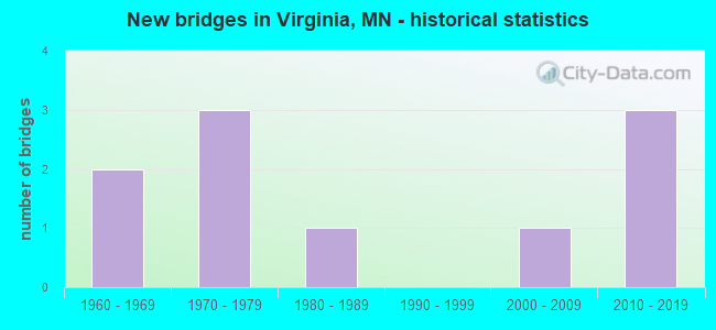
- New bridges - historical statistics
- 21960-1969
- 31970-1979
- 11980-1989
- 12000-2009
- 32010-2019
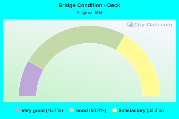
- Bridge Condition - Deck
- 16.7%Very good
- 50.0%Good
- 33.3%Satisfactory
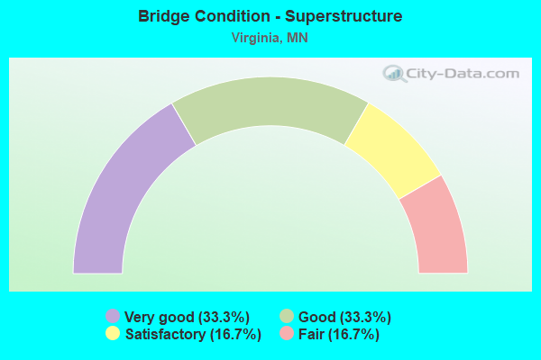
- Bridge Condition - Superstructure
- 33.3%Very good
- 33.3%Good
- 16.7%Satisfactory
- 16.7%Fair
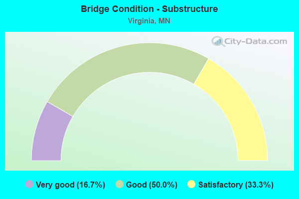
- Bridge Condition - Substructure
- 16.7%Very good
- 50.0%Good
- 33.3%Satisfactory
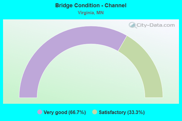
- Bridge Condition - Channel
- 66.7%Very good
- 33.3%Satisfactory
Find on map >> Show street view
Structure Number: 69009, Location: 1.3 MI SE OF JCT TH 169 (Lat: 47.509850, Lng: -92.541258), Route carried "on" structure: US 53, Year Built: 1962, Status: Open, Structure Length: 3.83m (12.57ft), Average Daily Traffic: 8,700 (year 2013), Truck Traffic: 4%, Average Future Daily Traffic: 8,700 (year 2039), Design Load: HS 20, Features Intersected: 6TH AVE W
Minimum Vertical Clearance: 30+ m (98+ ft), Kilometerpoint: 0.000, Lanes on structure: 2, Lanes under structure: 2, Base Highway Network: Yes, Owner: State Highway Agency, Approaching Roadway Width: 10.7m (35.1ft), Material/Design: Steel, Design/Construction: Stringer/Multi-beam, Number Of Spans In Main Unit: 3, Length of Maximum Span: 15.7m (51.5ft), Curb-To-Curb Width: 9.1m (29.9ft), Out-to-Out Width: 10.8m (35.4ft)
Condition: Deck: Good, Superstructure: Fair, Substructure: Satisfactory, Operating Rating: 70.7 metric tons, Method Used To Determine Operating Rating: Load Factor (LF), Inventory Rating: 42.3 metric tons, Method Used To Determine Inventory Rating: Load Factor (LF), Structural Evaluation: Somewhat better than minimum adequacy, Deck Geometry: Meets minimum limits, Underclear: Better than present minimum criteria, Approach Roadway Alignment: Better than present minimum criteria, Length Of Structure Improvement: 1.40m (4.59ft), Designated Inspection Frequency: Every 24 months, Inspection Date: August 2020, Bridge Improvement Cost: $569,000,000, Roadway Improvement Cost: $42,000,000, Total Project Cost: $633,000,000, Deck Structure Type: Concrete Cast-file-Place, Wearing Surface/Protective System: Wearing Surface: Low Slump Concrete
Find on map >> Show street view
Structure Number: 6901, Location: 1.3 MI SE OF JCT TH 169 (Lat: 47.510061, Lng: -92.541192), Route carried "on" structure: US 53, Year Built: 1970, Status: Open, Structure Length: 3.84m (12.60ft), Average Daily Traffic: 8,474 (year 2019), Truck Traffic: 5%, Average Future Daily Traffic: 8,700 (year 2039), Design Load: HS 20, Features Intersected: 6TH AVE W
Minimum Vertical Clearance: 30+ m (98+ ft), Kilometerpoint: 0.000, Lanes on structure: 2, Lanes under structure: 2, Base Highway Network: Yes, Owner: State Highway Agency, Approaching Roadway Width: 11.3m (37.1ft), Material/Design: Steel continuous, Design/Construction: Stringer/Multi-beam, Number Of Spans In Main Unit: 3, Length of Maximum Span: 15.9m (52.2ft), Curb-To-Curb Width: 12.3m (40.4ft), Out-to-Out Width: 13.6m (44.6ft)
Condition: Deck: Satisfactory, Superstructure: Satisfactory, Substructure: Good, Operating Rating: 49.0 metric tons, Method Used To Determine Operating Rating: Load Factor (LF), Inventory Rating: 31.7 metric tons, Method Used To Determine Inventory Rating: Load Factor (LF), Structural Evaluation: Equal to present minimum criteria, Deck Geometry: Better than present minimum criteria, Underclear: Better than present minimum criteria, Approach Roadway Alignment: Equal to present desirable criteria, Designated Inspection Frequency: Every 24 months, Inspection Date: August 2020, Deck Structure Type: Concrete Cast-file-Place, Wearing Surface/Protective System: Wearing Surface: Low Slump Concrete
Find on map >> Show street view
Structure Number: 69129, Location: 1.0 MI N OF JCT TH 135 (Lat: 47.515853, Lng: -92.522597), Route carried "on" structure: US 53, Year Built: 2017, Status: Open, Structure Length: 34.51m (113.22ft), Average Daily Traffic: 22,200 (year 2019), Truck Traffic: 4%, Average Future Daily Traffic: 23,400 (year 2039), Design Load: HL 93, Features Intersected: ROUCHLEAU PIT
Minimum Vertical Clearance: 30+ m (98+ ft), Kilometerpoint: 0.000, Lanes on structure: 4, Base Highway Network: Yes, Owner: State Highway Agency, Approaching Roadway Width: 21.9m (71.9ft), Skew: 30 degrees, Material/Design: Steel continuous, Design/Construction: Stringer/Multi-beam, Number Of Spans In Main Unit: 3, Length of Maximum Span: 146.3m (480.0ft), Curb or Sidewalk Widths: Left: 4.3m (14.1ft), Right: 0.0m, Curb-To-Curb Width: 21.9m (71.9ft), Out-to-Out Width: 28.0m (91.9ft)
Condition: Deck: Satisfactory, Superstructure: Very good, Substructure: Good, Operating Rating: 47.0 metric tons, Method Used To Determine Operating Rating: Load and Resistance Factor Rating (LRFR) rating reported by rating factor(RF) method using HL-93 loadings, Inventory Rating: 36.3 metric tons, Method Used To Determine Inventory Rating: Load and Resistance Factor Rating (LRFR) rating reported by rating factor(RF) method using HL-93 loadings, Structural Evaluation: Better than present minimum criteria, Deck Geometry: Superior to present desirable criteria, Waterway Adequacy: Equal to present desirable criteria, Approach Roadway Alignment: Better than present minimum criteria, Designated Inspection Frequency: Every 24 months, Inspection Date: October 2020, Deck Structure Type: Concrete Cast-file-Place, Wearing Surface/Protective System: Wearing Surface: Monolithic Concrete, Deck Protection: Other
Find on map >> Show street view
Structure Number: 6913, Location: 0.1 MI N OF JCT US 53 (Lat: 47.502011, Lng: -92.518258), Route carried "on" structure: State highway 135, Year Built: 2016, Status: Open, Structure Length: 5.12m (16.80ft), Average Daily Traffic: 8,200 (year 2019), Truck Traffic: 9%, Average Future Daily Traffic: 8,800 (year 2039), Design Load: HL 93, Features Intersected: US 53
Minimum Vertical Clearance: 30+ m (98+ ft), Kilometerpoint: 0.000, Lanes on structure: 2, Lanes under structure: 4, Owner: State Highway Agency, Approaching Roadway Width: 13.4m (44.0ft), Material/Design: Prestressed concrete, Design/Construction: Stringer/Multi-beam, Number Of Spans In Main Unit: 2, Length of Maximum Span: 25.1m (82.3ft), Curb-To-Curb Width: 13.4m (44.0ft), Out-to-Out Width: 13.4m (44.0ft)
Condition: Deck: Very good, Superstructure: Very good, Substructure: Very good, Operating Rating: 60.6 metric tons, Method Used To Determine Operating Rating: Load and Resistance Factor Rating (LRFR) rating reported by rating factor(RF) method using HL-93 loadings, Inventory Rating: 37.6 metric tons, Method Used To Determine Inventory Rating: Load and Resistance Factor Rating (LRFR) rating reported by rating factor(RF) method using HL-93 loadings, Structural Evaluation: Equal to present desirable criteria, Deck Geometry: Equal to present minimum criteria, Underclear: Equal to present desirable criteria, Approach Roadway Alignment: Equal to present desirable criteria, Designated Inspection Frequency: Every 24 months, Inspection Date: August 2021, Deck Structure Type: Concrete Cast-file-Place, Wearing Surface/Protective System: Wearing Surface: Low Slump Concrete, Deck Protection: Epoxy Coated Reinforcing
Find on map >> Show street view
Structure Number: 69528, Location: 0.3 MI S OF JCT TH 135 (Lat: 47.526150, Lng: -92.541008), Route carried "on" structure: City street 220, Year Built: 1980, Status: Open, Structure Length: 1.45m (4.76ft), Average Daily Traffic: 5,000 (year 2015), Average Future Daily Traffic: 5,000 (year 2039), Design Load: HS 20, Features Intersected: SILVER CREEK
Minimum Vertical Clearance: 30+ m (98+ ft), Kilometerpoint: 0.000, Lanes on structure: 2, Owner: City or Municipal Highway Agency, Approaching Roadway Width: 14.6m (47.9ft), Material/Design: Prestressed concrete, Design/Construction: Tee Beam, Number Of Spans In Main Unit: 1, Length of Maximum Span: 13.7m (44.9ft), Curb or Sidewalk Widths: Left: 2.8m (9.2ft), Right: 2.8m (9.2ft), Curb-To-Curb Width: 14.3m (46.9ft), Out-to-Out Width: 20.6m (67.6ft)
Condition: Deck: Good, Superstructure: Good, Substructure: Satisfactory, Channel: Very good, Operating Rating: 54.5 metric tons, Method Used To Determine Operating Rating: Field evaluation and documented engineering judgment, Inventory Rating: 32.7 metric tons, Method Used To Determine Inventory Rating: Field evaluation and documented engineering judgment, Structural Evaluation: Equal to present minimum criteria, Deck Geometry: Superior to present desirable criteria, Waterway Adequacy: Equal to present desirable criteria, Approach Roadway Alignment: Equal to present desirable criteria, Designated Inspection Frequency: Every 24 months, Inspection Date: August 2020, Deck Structure Type: Concrete Cast-file-Place, Wearing Surface/Protective System: Wearing Surface: Bituminous
Find on map >> Show street view
Structure Number: 69642, Location: 0.04 MI S OF JCT 1ST ST (Lat: 47.521531, Lng: -92.546806), Route carried "on" structure: City street 219, Year Built: 2003, Status: Open, Structure Length: 0.73m (2.40ft), Average Daily Traffic: 6,300 (year 2011), Average Future Daily Traffic: 6,300 (year 2030), Design Load: HS 25 or greater, Features Intersected: SILVER CREEK
Minimum Vertical Clearance: 30+ m (98+ ft), Kilometerpoint: 0.000, Lanes on structure: 2, Owner: City or Municipal Highway Agency, Approaching Roadway Width: 13.4m (44.0ft), Material/Design: Concrete, Design/Construction: Slab, Number Of Spans In Main Unit: 1, Length of Maximum Span: 6.4m (21.0ft), Curb or Sidewalk Widths: Left: 2.4m (7.9ft), Right: 2.4m (7.9ft), Curb-To-Curb Width: 13.4m (44.0ft), Out-to-Out Width: 19.9m (65.3ft)
Condition: Deck: Good, Superstructure: Good, Substructure: Good, Channel: Very good, Operating Rating: 70.8 metric tons, Method Used To Determine Operating Rating: Load Factor (LF), Inventory Rating: 42.4 metric tons, Method Used To Determine Inventory Rating: Load Factor (LF), Structural Evaluation: Better than present minimum criteria, Deck Geometry: Equal to present minimum criteria, Waterway Adequacy: Superior to present desirable criteria, Approach Roadway Alignment: Equal to present desirable criteria, Designated Inspection Frequency: Every 24 months, Inspection Date: August 2020, Deck Structure Type: Concrete Cast-file-Place, Wearing Surface/Protective System: Wearing Surface: Low Slump Concrete, Deck Protection: Epoxy Coated Reinforcing
Find on map >> Show street view
Structure Number: 91261, Location: 0.4 MI E OF JCT 9 AVE (Lat: 47.530542, Lng: -92.538519), Route carried "on" structure: City street 225, Year Built: 1972, Status: Open, Structure Length: 1.10m (3.61ft), Average Daily Traffic: 5,650 (year 2015), Average Future Daily Traffic: 5,650 (year 2039), Design Load: HS 20, Features Intersected: SILVER CREEK
Minimum Vertical Clearance: 30+ m (98+ ft), Kilometerpoint: 0.000, Lanes on structure: 4, Owner: City or Municipal Highway Agency, Approaching Roadway Width: 14.6m (47.9ft), Skew: 1 degrees, Material/Design: Concrete, Design/Construction: Culvert, Number Of Spans In Main Unit: 3, Length of Maximum Span: 2.6m (8.5ft)
Condition: Channel: Satisfactory, Culverts: Satisfactory, Operating Rating: 39.2 metric tons, Method Used To Determine Operating Rating: Assigned ratings based on Allowable Stress Design (ASD) reported in metric tons, Inventory Rating: 29.4 metric tons, Method Used To Determine Inventory Rating: Assigned ratings based on Allowable Stress Design (ASD) reported in metric tons, Structural Evaluation: Equal to present minimum criteria, Waterway Adequacy: Equal to present desirable criteria, Approach Roadway Alignment: Equal to present desirable criteria, Designated Inspection Frequency: Every 24 months, Inspection Date: August 2020
Find on map >> Show street view
Structure Number: 69009, Location: 1.3 MI SE OF JCT TH 169 (Lat: 47.509850, Lng: -92.541258), Route carried "under" structure: City street 50, Year Built: 1962, Structure Length: 0. m, Average Daily Traffic: 1,800 (year 2011), Features Intersected: 6TH AVE W, Facility Carried by Structure: US 53
Minimum Vertical Clearance: 4.79m (15.72ft), Kilometerpoint: 0.000, Lanes on structure: 2, Lanes under structure: 2, Material/Design: Steel, Design/Construction: Stringer/Multi-beam, Length of Maximum Span: 15.7m (51.5ft)
Find on map >> Show street view
Structure Number: 6901, Location: 1.3 MI SE OF JCT TH 169 (Lat: 47.510061, Lng: -92.541192), Route carried "under" structure: City street 223, Year Built: 1970, Structure Length: 0. m, Average Daily Traffic: 1,800 (year 2011), Features Intersected: 6TH AVE W, Facility Carried by Structure: US 53
Minimum Vertical Clearance: 4.94m (16.21ft), Kilometerpoint: 0.000, Lanes on structure: 2, Lanes under structure: 2, Material/Design: Steel continuous, Design/Construction: Stringer/Multi-beam, Length of Maximum Span: 15.9m (52.2ft)
Find on map >> Show street view
Structure Number: 6913, Location: 0.1 MI N OF JCT US 53 (Lat: 47.502011, Lng: -92.518258), Route carried "under" structure: US 53, Year Built: 2016, Structure Length: 0. m, Average Daily Traffic: 22,200 (year 2019), Truck Traffic: 4%, Features Intersected: US 53, Facility Carried by Structure: MN 135
Minimum Vertical Clearance: 5.55m (18.21ft), Kilometerpoint: 0.000, Lanes under structure: 4, Material/Design: Prestressed concrete, Design/Construction: Stringer/Multi-beam, Length of Maximum Span: 25.1m (82.3ft)