Bridge Statistics for Volney, New York (NY)
Condition, Traffic, Stress, Structural Evaluation, Project Costs
- National Bridge Inventory (NBI) Statistics
- 13Number of bridges
- 69ft / 21.4mTotal length
- $13,971,000Total costs
- 41,349Total average daily traffic
- 1,504Total average daily truck traffic
- National Bridge Inventory (NBI) Registered Bridges for Volney
- No street view available for this location
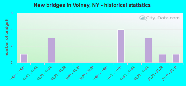
- New bridges - historical statistics
- 11900-1909
- 31920-1929
- 41970-1979
- 31990-1999
- 12000-2009
- 12010-2019

- Reconstructed bridges - Historical Statistics
- 11970-1979
- 01980-1989
- 11990-1999


- Bridge Condition - Deck
- 14.3%Very good
- 42.9%Good
- 28.6%Satisfactory
- 14.3%Fair

- Bridge Condition - Superstructure
- 28.6%Very good
- 28.6%Good
- 14.3%Satisfactory
- 28.6%Fair

- Bridge Condition - Substructure
- 14.3%Excellent
- 28.6%Good
- 28.6%Satisfactory
- 28.6%Fair

- Bridge Condition - Channel
- 16.7%Very good
- 33.3%Satisfactory
- 33.3%Fair
- 16.7%Poor
Find on map >> Show street view
Structure Number: 102744, Location: 2 MI N JCT RT 57 & FULTON (Lat: 43.364539, Lng: -76.429717), Route carried "on" structure: State highway 481, Year Built: 1994, Status: Open, Structure Length: 1.86m (6.10ft), Average Daily Traffic: 7,674 (year 2020), Truck Traffic: 6%, Average Future Daily Traffic: 7,710 (year 2040), Design Load: HS 25 or greater, Features Intersected: BLACK CREEK
Minimum Vertical Clearance: 30+ m (98+ ft), Kilometerpoint: 23.411, Lanes on structure: 4, Base Highway Network: Yes, Owner: State Highway Agency, Approaching Roadway Width: 24.4m (80.1ft), Skew: 20 degrees, Material/Design: Prestressed concrete, Design/Construction: Box Beam or Girders - Multiple, Number Of Spans In Main Unit: 1, Length of Maximum Span: 18.2m (59.7ft), Curb-To-Curb Width: 24.4m (80.1ft), Out-to-Out Width: 25.0m (82.0ft)
Condition: Deck: Satisfactory, Superstructure: Good, Substructure: Good, Channel: Very good, Operating Rating: 78.0 metric tons, Method Used To Determine Operating Rating: Load Factor (LF), Inventory Rating: 46.3 metric tons, Method Used To Determine Inventory Rating: Load Factor (LF), Structural Evaluation: Better than present minimum criteria, Deck Geometry: Superior to present desirable criteria, Waterway Adequacy: Equal to present minimum criteria, Approach Roadway Alignment: Equal to present desirable criteria, Length Of Structure Improvement: 1.85m (6.07ft), Designated Inspection Frequency: Every 24 months, Inspection Date: April 2020, Bridge Improvement Cost: $1,727,000, Roadway Improvement Cost: $1,011,000, Total Project Cost: $2,738,000 ( Estimate for 2021), Wearing Surface/Protective System: Wearing Surface: Monolithic Concrete
Find on map >> Show street view
Structure Number: 103933, Location: 6.2 MI NORTH OF FULTON (Lat: 43.405306, Lng: -76.400878), Route carried "on" structure: County highway , Year Built: 1929, Year Reconstructed: 2004, Status: Open, Structure Length: 0.79m (2.59ft), Average Daily Traffic: 1,314 (year 2020), Truck Traffic: 7%, Average Future Daily Traffic: 1,840 (year 2040), Features Intersected: BLACK CREEK, Facility Carried by Structure: WHITAKER ROAD
Minimum Vertical Clearance: 30+ m (98+ ft), Kilometerpoint: 8.319, Lanes on structure: 2, Owner: County Highway Agency, Approaching Roadway Width: 7.6m (24.9ft), Skew: 3 degrees, Material/Design: Concrete, Design/Construction: Slab, Number Of Spans In Main Unit: 1, Length of Maximum Span: 6.7m (22.0ft), Curb-To-Curb Width: 8.1m (26.6ft), Out-to-Out Width: 8.7m (28.5ft)
Condition: Deck: Fair, Superstructure: Fair, Substructure: Fair, Channel: Satisfactory, Operating Rating: 68.0 metric tons, Method Used To Determine Operating Rating: Load Factor (LF), Inventory Rating: 40.8 metric tons, Method Used To Determine Inventory Rating: Load Factor (LF), Structural Evaluation: Somewhat better than minimum adequacy, Deck Geometry: Meets minimum limits, Waterway Adequacy: Somewhat better than minimum adequacy, Approach Roadway Alignment: Equal to present desirable criteria, Length Of Structure Improvement: 0.79m (2.59ft), Designated Inspection Frequency: Every 24 months, Inspection Date: August 2020, Bridge Improvement Cost: $633,000, Roadway Improvement Cost: $371,000, Total Project Cost: $1,004,000 ( Estimate for 2021), Deck Structure Type: Concrete Cast-file-Place, Wearing Surface/Protective System: Wearing Surface: Bituminous
Find on map >> Show street view
Structure Number: 106474, Location: 3.9 MI NW JCT RTS 481+264 (Lat: 43.298086, Lng: -76.350372), Route carried "on" structure: Other road , Year Built: 1970, Status: Open, Structure Length: 6.34m (20.80ft), Average Daily Traffic: 277 (year 2019), Truck Traffic: 8%, Average Future Daily Traffic: 388 (year 2039), Design Load: H 20, Features Intersected: 481 481 34021075, RTE 48, Facility Carried by Structure: OWEN ROAD
Minimum Vertical Clearance: 30+ m (98+ ft), Kilometerpoint: 2.993, Lanes on structure: 2, Lanes under structure: 4, Owner: State Highway Agency, Approaching Roadway Width: 9.1m (29.9ft), Skew: 2 degrees, Material/Design: Steel, Design/Construction: Stringer/Multi-beam, Number Of Spans In Main Unit: 2, Length of Maximum Span: 33.2m (108.9ft), Curb-To-Curb Width: 10.7m (35.1ft), Out-to-Out Width: 11.6m (38.1ft)
Condition: Deck: Satisfactory, Superstructure: Very good, Substructure: Good, Operating Rating: 68.9 metric tons, Method Used To Determine Operating Rating: Load Factor (LF), Inventory Rating: 40.8 metric tons, Method Used To Determine Inventory Rating: Load Factor (LF), Structural Evaluation: Better than present minimum criteria, Deck Geometry: Better than present minimum criteria, Underclear: Somewhat better than minimum adequacy, Approach Roadway Alignment: Equal to present desirable criteria, Length Of Structure Improvement: 6.33m (20.77ft), Designated Inspection Frequency: Every 24 months, Inspection Date: April 2020, Bridge Improvement Cost: $1,681,000, Roadway Improvement Cost: $985,000, Total Project Cost: $2,666,000 ( Estimate for 2021), Deck Structure Type: Concrete Cast-file-Place, Wearing Surface/Protective System: Wearing Surface: Monolithic Concrete
Find on map >> Show street view
Structure Number: 1064751, Location: .2 MI E JCT SH481 & CR57 (Lat: 43.306300, Lng: -76.382033), Route carried "on" structure: State highway 481, Year Built: 1970, Status: Open, Structure Length: 3.93m (12.89ft), Average Daily Traffic: 4,664 (year 2020), Truck Traffic: 7%, Average Future Daily Traffic: 6,812 (year 2040), Design Load: H 20, Features Intersected: CSX TRANSPRTATION
Minimum Vertical Clearance: 30+ m (98+ ft), Kilometerpoint: 14.851, Lanes on structure: 2, Base Highway Network: Yes, Owner: State Highway Agency, Approaching Roadway Width: 10.4m (34.1ft), Skew: 3 degrees, Material/Design: Steel, Design/Construction: Stringer/Multi-beam, Number Of Spans In Main Unit: 1, Length of Maximum Span: 37.7m (123.7ft), Curb-To-Curb Width: 11.9m (39.0ft), Out-to-Out Width: 12.8m (42.0ft)
Condition: Deck: Good, Superstructure: Good, Substructure: Satisfactory, Operating Rating: 82.6 metric tons, Method Used To Determine Operating Rating: Load Factor (LF), Inventory Rating: 49.0 metric tons, Method Used To Determine Inventory Rating: Load Factor (LF), Structural Evaluation: Equal to present minimum criteria, Deck Geometry: Better than present minimum criteria, Underclear: Better than present minimum criteria, Approach Roadway Alignment: Equal to present desirable criteria, Length Of Structure Improvement: 3.93m (12.89ft), Designated Inspection Frequency: Every 24 months, Inspection Date: August 2020, Bridge Improvement Cost: $1,625,000, Roadway Improvement Cost: $952,000, Total Project Cost: $2,577,000 ( Estimate for 2021), Deck Structure Type: Concrete Cast-file-Place, Wearing Surface/Protective System: Wearing Surface: Monolithic Concrete
Find on map >> Show street view
Structure Number: 1064752, Location: .2 MI E JCT SH481 & CR57 (Lat: 43.306489, Lng: -76.382222), Route carried "on" structure: State highway 481, Year Built: 1970, Year Reconstructed: 1981, Status: Open, Structure Length: 3.93m (12.89ft), Average Daily Traffic: 4,664 (year 2020), Truck Traffic: 7%, Average Future Daily Traffic: 6,812 (year 2040), Design Load: H 20, Features Intersected: CSX TRANSPRTATION
Minimum Vertical Clearance: 30+ m (98+ ft), Kilometerpoint: 14.851, Lanes on structure: 2, Base Highway Network: Yes, Owner: State Highway Agency, Approaching Roadway Width: 10.4m (34.1ft), Skew: 3 degrees, Material/Design: Steel, Design/Construction: Stringer/Multi-beam, Number Of Spans In Main Unit: 1, Length of Maximum Span: 37.7m (123.7ft), Curb-To-Curb Width: 11.9m (39.0ft), Out-to-Out Width: 12.8m (42.0ft)
Condition: Deck: Good, Superstructure: Satisfactory, Substructure: Satisfactory, Operating Rating: 82.6 metric tons, Method Used To Determine Operating Rating: Load Factor (LF), Inventory Rating: 49.0 metric tons, Method Used To Determine Inventory Rating: Load Factor (LF), Structural Evaluation: Equal to present minimum criteria, Deck Geometry: Better than present minimum criteria, Underclear: Meets minimum limits, Approach Roadway Alignment: Equal to present desirable criteria, Length Of Structure Improvement: 3.93m (12.89ft), Designated Inspection Frequency: Every 24 months, Inspection Date: August 2020, Bridge Improvement Cost: $1,625,000, Roadway Improvement Cost: $952,000, Total Project Cost: $2,577,000 ( Estimate for 2021), Deck Structure Type: Concrete Cast-file-Place, Wearing Surface/Protective System: Wearing Surface: Monolithic Concrete
Find on map >> Show street view
Structure Number: 320934, Location: 4.0 MI E OF MINETTO (Lat: 43.406081, Lng: -76.407553), Route carried "on" structure: Other road , Year Built: 2013, Status: Open, Structure Length: 1.25m (4.10ft), Average Daily Traffic: 215 (year 2018), Truck Traffic: 2%, Average Future Daily Traffic: 301 (year 2038), Design Load: HS 20, Features Intersected: BLACK CREEK, Facility Carried by Structure: BLACK CREEK ROAD
Minimum Vertical Clearance: 30+ m (98+ ft), Kilometerpoint: 0.628, Lanes on structure: 2, Owner: County Highway Agency, Approaching Roadway Width: 6.7m (22.0ft), Material/Design: Steel, Design/Construction: Stringer/Multi-beam, Number Of Spans In Main Unit: 1, Length of Maximum Span: 12.2m (40.0ft), Curb-To-Curb Width: 8.8m (28.9ft), Out-to-Out Width: 9.0m (29.5ft)
Condition: Deck: Very good, Superstructure: Very good, Substructure: Excellent, Channel: Satisfactory, Operating Rating: 88.0 metric tons, Method Used To Determine Operating Rating: Allowable Stress (AS), Inventory Rating: 60.8 metric tons, Method Used To Determine Inventory Rating: Allowable Stress (AS), Structural Evaluation: Equal to present desirable criteria, Deck Geometry: Equal to present minimum criteria, Waterway Adequacy: Somewhat better than minimum adequacy, Approach Roadway Alignment: Equal to present minimum criteria, Length Of Structure Improvement: 1.24m (4.07ft), Designated Inspection Frequency: Every 24 months, Inspection Date: July 2021, Bridge Improvement Cost: $322,000, Roadway Improvement Cost: $189,000, Total Project Cost: $511,000 ( Estimate for 2021), Deck Structure Type: Corrugated Steel, Wearing Surface/Protective System: Wearing Surface: Bituminous
Find on map >> Show street view
Structure Number: 331334, Location: 3.7 MI N OF FULTON (Lat: 43.368847, Lng: -76.426181), Route carried "on" structure: County highway , Year Built: 1996, Status: Open, Structure Length: 1.37m (4.49ft), Average Daily Traffic: 1,097 (year 2020), Truck Traffic: 7%, Average Future Daily Traffic: 1,357 (year 2040), Features Intersected: BLACK CREEK, Facility Carried by Structure: COUNTY ROAD 57
Minimum Vertical Clearance: 30+ m (98+ ft), Kilometerpoint: 3.572, Lanes on structure: 2, Owner: County Highway Agency, Approaching Roadway Width: 12.5m (41.0ft), Material/Design: Steel, Design/Construction: Culvert, Number Of Spans In Main Unit: 2, Length of Maximum Span: 6.4m (21.0ft)
Condition: Channel: Fair, Culverts: Fair, Operating Rating: 75.3 metric tons, Method Used To Determine Operating Rating: Field evaluation and documented engineering judgment, Inventory Rating: 24.5 metric tons, Method Used To Determine Inventory Rating: Field evaluation and documented engineering judgment, Structural Evaluation: Somewhat better than minimum adequacy, Waterway Adequacy: Meets minimum limits, Approach Roadway Alignment: Equal to present minimum criteria, Length Of Structure Improvement: 1.37m (4.49ft), Designated Inspection Frequency: Every 24 months, Inspection Date: August 2020, Bridge Improvement Cost: $397,000, Roadway Improvement Cost: $233,000, Total Project Cost: $630,000 ( Estimate for 2021), Wearing Surface/Protective System: Wearing Surface: Bituminous
Find on map >> Show street view
Structure Number: 331357, Location: 2.5 MI E OF MINETTO (Lat: 43.401928, Lng: -76.429656), Route carried "on" structure: County highway , Year Built: 1991, Status: Open, Structure Length: 1.13m (3.71ft), Average Daily Traffic: 296 (year 2017), Truck Traffic: 8%, Average Future Daily Traffic: 414 (year 2037), Features Intersected: BLACK CREEK, Facility Carried by Structure: SUCKERVILLE ROAD
Minimum Vertical Clearance: 30+ m (98+ ft), Kilometerpoint: 3.492, Lanes on structure: 2, Owner: County Highway Agency, Approaching Roadway Width: 7.3m (24.0ft), Material/Design: Steel, Design/Construction: Culvert, Number Of Spans In Main Unit: 2, Length of Maximum Span: 5.1m (16.7ft)
Condition: Channel: Fair, Culverts: Fair, Operating Rating: 74.8 metric tons, Method Used To Determine Operating Rating: Field evaluation and documented engineering judgment, Inventory Rating: 19.6 metric tons, Method Used To Determine Inventory Rating: Field evaluation and documented engineering judgment, Structural Evaluation: Somewhat better than minimum adequacy, Waterway Adequacy: Meets minimum limits, Approach Roadway Alignment: Better than present minimum criteria, Length Of Structure Improvement: 1.12m (3.67ft), Designated Inspection Frequency: Every 24 months, Inspection Date: September 2020, Bridge Improvement Cost: $191,000, Roadway Improvement Cost: $112,000, Total Project Cost: $303,000 ( Estimate for 2021)
Find on map >> Show street view
Structure Number: 33668, Location: 6.5 MILES SW OF MEXICO (Lat: 43.423294, Lng: -76.361456), Route carried "on" structure: County highway , Year Built: 2005, Status: Open, Structure Length: 0.82m (2.69ft), Average Daily Traffic: 1,761 (year 2017), Truck Traffic: 10%, Average Future Daily Traffic: 2,465 (year 2037), Features Intersected: SWAMP CREEK, Facility Carried by Structure: COUNTY ROAD 4
Minimum Vertical Clearance: 30+ m (98+ ft), Kilometerpoint: 9.944, Lanes on structure: 2, Owner: County Highway Agency, Approaching Roadway Width: 8.8m (28.9ft), Skew: 1 degrees, Material/Design: Steel, Design/Construction: Stringer/Multi-beam, Number Of Spans In Main Unit: 1, Length of Maximum Span: 7.9m (25.9ft), Curb-To-Curb Width: 9.1m (29.9ft), Out-to-Out Width: 9.7m (31.8ft)
Condition: Deck: Good, Superstructure: Fair, Substructure: Fair, Channel: Poor, Operating Rating: 88.9 metric tons, Method Used To Determine Operating Rating: Load Factor (LF), Inventory Rating: 53.5 metric tons, Method Used To Determine Inventory Rating: Load Factor (LF), Structural Evaluation: Somewhat better than minimum adequacy, Deck Geometry: Somewhat better than minimum adequacy, Waterway Adequacy: Somewhat better than minimum adequacy, Approach Roadway Alignment: Better than present minimum criteria, Length Of Structure Improvement: 0.82m (2.69ft), Designated Inspection Frequency: Every 24 months, Inspection Date: August 2021, Bridge Improvement Cost: $609,000, Roadway Improvement Cost: $357,000, Total Project Cost: $965,000 ( Estimate for 2021), Deck Structure Type: Corrugated Steel, Wearing Surface/Protective System: Wearing Surface: Bituminous
Find on map >> Show street view
Structure Number: 106474, Location: 3.9 MI NW JCT RTS 481+264 (Lat: 43.298086, Lng: -76.350372), Route carried "under" structure: State highway 481, Year Built: 1970, Structure Length: 0. m, Average Daily Traffic: 14,887 (year 2002), Features Intersected: 481 481 34021075, RTE 48, Facility Carried by Structure: OWEN ROAD
Minimum Vertical Clearance: 6.07m (19.91ft), Kilometerpoint: 12.068, Lanes on structure: 2, Lanes under structure: 2, Material/Design: Steel, Design/Construction: Stringer/Multi-beam, Length of Maximum Span: 33.2m (108.9ft)
Find on map >> Show street view
Structure Number: 700031, Location: .6 MI NE JCT SH 3 & CR 9 (Lat: 43.330322, Lng: -76.399500), Route carried "under" structure: State highway 3, Year Built: 1928, Structure Length: 0. m, Average Daily Traffic: 3,800 (year 1972), Features Intersected: RTE 3, Facility Carried by Structure: CSX TRANSPRTATION
Minimum Vertical Clearance: 4.36m (14.30ft), Kilometerpoint: 0.161, Lanes under structure: 2, Material/Design: Steel, Design/Construction: Stringer/Multi-beam, Length of Maximum Span: 17.0m (55.8ft)
Find on map >> Show street view
Structure Number: 703932, Location: 1.1 MI NE BARGE CNL & SH3 (Lat: 43.333014, Lng: -76.403814), Route carried "under" structure: County highway , Year Built: 1928, Structure Length: 0. m, Average Daily Traffic: 500 (year 1972), Features Intersected: COUNTY ROAD 176, Facility Carried by Structure: CSX TRANSPRTATION
Minimum Vertical Clearance: 4.49m (14.73ft), Kilometerpoint: 0.000, Lanes under structure: 2, Material/Design: Steel, Design/Construction: Girder and Floorbeam System, Length of Maximum Span: 18.2m (59.7ft)
Find on map >> Show street view
Structure Number: 770229, Location: 1.0 MI E OF FULTON (Lat: 43.326206, Lng: -76.394097), Route carried "under" structure: Other road , Year Built: 1900, Structure Length: 0. m, Average Daily Traffic: 200 (year 2021), Features Intersected: EMERY STREET-CR 9, Facility Carried by Structure: CSX TRANSPRTATION
Minimum Vertical Clearance: 3.93m (12.89ft), Kilometerpoint: 0.000, Lanes under structure: 2, Material/Design: Steel, Design/Construction: Girder and Floorbeam System, Length of Maximum Span: 18.2m (59.7ft)