Bridge Statistics for Waddington, New York (NY)
Condition, Traffic, Stress, Structural Evaluation, Project Costs
- National Bridge Inventory (NBI) Statistics
- 13Number of bridges
- 105ft / 31.9mTotal length
- $14,161,000Total costs
- 12,479Total average daily traffic
- 1,844Total average daily truck traffic
- 14,009Total future (year 2037) average daily traffic
- National Bridge Inventory (NBI) Registered Bridges for Waddington
- No street view available for this location
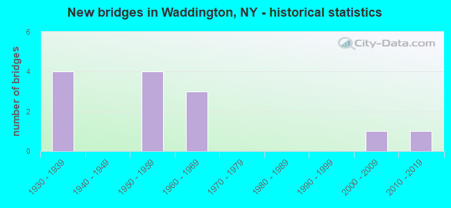
- New bridges - historical statistics
- 41930-1939
- 41950-1959
- 31960-1969
- 12000-2009
- 12010-2019

- Reconstructed bridges - Historical Statistics
- 11970-1979
- 01980-1989
- 01990-1999
- 02000-2009
- 22010-2019

- Bridge Condition - Deck
- 16.7%Excellent
- 8.3%Very good
- 41.7%Good
- 25.0%Satisfactory
- 8.3%Fair

- Bridge Condition - Superstructure
- 33.3%Excellent
- 41.7%Good
- 8.3%Satisfactory
- 16.7%Fair

- Bridge Condition - Substructure
- 16.7%Excellent
- 8.3%Very good
- 58.3%Good
- 16.7%Fair

- Bridge Condition - Channel
- 7.7%Excellent
- 23.1%Very good
- 38.5%Good
- 23.1%Satisfactory
- 7.7%Fair
Find on map >> Show street view
Structure Number: 102386, Location: 0.3 MI NE JCT 37 + 345 (Lat: 44.867297, Lng: -75.192286), Route carried "on" structure: State highway 37, Year Built: 1957, Status: Open, Structure Length: 2.35m (7.71ft), Average Daily Traffic: 2,754 (year 2020), Truck Traffic: 18%, Average Future Daily Traffic: 2,780 (year 2040), Design Load: H 20, Features Intersected: BIG SUCKER BROOK
Minimum Vertical Clearance: 30+ m (98+ ft), Kilometerpoint: 76.492, Lanes on structure: 2, Base Highway Network: Yes, Owner: State Highway Agency, Approaching Roadway Width: 13.4m (44.0ft), Material/Design: Steel, Design/Construction: Stringer/Multi-beam, Number Of Spans In Main Unit: 1, Length of Maximum Span: 22.8m (74.8ft), Curb-To-Curb Width: 11.0m (36.1ft), Out-to-Out Width: 12.5m (41.0ft)
Condition: Deck: Good, Superstructure: Good, Substructure: Fair, Channel: Satisfactory, Operating Rating: 58.1 metric tons, Method Used To Determine Operating Rating: Load Factor (LF), Inventory Rating: 34.5 metric tons, Method Used To Determine Inventory Rating: Load Factor (LF), Structural Evaluation: Somewhat better than minimum adequacy, Deck Geometry: Somewhat better than minimum adequacy, Waterway Adequacy: Equal to present minimum criteria, Approach Roadway Alignment: Equal to present desirable criteria, Length Of Structure Improvement: 2.34m (7.68ft), Designated Inspection Frequency: Every 24 months, Underwater Inspection Frequency: Every 60 months, Inspection Date: August 2021, Underwater Inspection Date: August 2017, Bridge Improvement Cost: $1,285,000, Roadway Improvement Cost: $752,000, Total Project Cost: $2,037,000 ( Estimate for 2021), Deck Structure Type: Concrete Cast-file-Place, Wearing Surface/Protective System: Wearing Surface: Bituminous, Membrane: Other
Find on map >> Show street view
Structure Number: 102387, Location: 1.8 MI NE JCT SH37 &SH345 (Lat: 44.873069, Lng: -75.162408), Route carried "on" structure: State highway 37, Year Built: 1957, Year Reconstructed: 2017, Status: Open, Structure Length: 9.72m (31.89ft), Average Daily Traffic: 2,754 (year 2020), Truck Traffic: 18%, Average Future Daily Traffic: 2,780 (year 2040), Design Load: HS 20, Features Intersected: BRANDY BROOK
Minimum Vertical Clearance: 30+ m (98+ ft), Kilometerpoint: 79.195, Lanes on structure: 2, Base Highway Network: Yes, Owner: State Highway Agency, Approaching Roadway Width: 13.4m (44.0ft), Material/Design: Steel, Design/Construction: Stringer/Multi-beam, Number Of Spans In Main Unit: 4, Length of Maximum Span: 24.0m (78.7ft), Curb-To-Curb Width: 12.2m (40.0ft), Out-to-Out Width: 13.2m (43.3ft)
Condition: Deck: Very good, Superstructure: Good, Substructure: Good, Channel: Good, Operating Rating: 80.7 metric tons, Method Used To Determine Operating Rating: Load Factor (LF), Inventory Rating: 48.1 metric tons, Method Used To Determine Inventory Rating: Load Factor (LF), Structural Evaluation: Better than present minimum criteria, Deck Geometry: Equal to present minimum criteria, Waterway Adequacy: Equal to present desirable criteria, Approach Roadway Alignment: Equal to present desirable criteria, Length Of Structure Improvement: 9.72m (31.89ft), Designated Inspection Frequency: Every 24 months, Underwater Inspection Frequency: Every 60 months, Inspection Date: August 2021, Underwater Inspection Date: August 2017, Bridge Improvement Cost: $2,923,000, Roadway Improvement Cost: $1,711,000, Total Project Cost: $4,634,000 ( Estimate for 2021), Deck Structure Type: Concrete Cast-file-Place, Wearing Surface/Protective System: Wearing Surface: Integral Concrete, Deck Protection: Epoxy Coated Reinforcing
Find on map >> Show street view
Structure Number: 104622, Location: 1.6 MI SE JCT SH345 &SH37 (Lat: 44.841011, Lng: -75.190875), Route carried "on" structure: State highway 345, Year Built: 1935, Status: Open, Structure Length: 1.16m (3.81ft), Average Daily Traffic: 1,221 (year 2020), Truck Traffic: 16%, Average Future Daily Traffic: 1,273 (year 2040), Design Load: H 20, Features Intersected: LITTLE SUCKER BRK
Minimum Vertical Clearance: 30+ m (98+ ft), Kilometerpoint: 26.098, Lanes on structure: 2, Base Highway Network: Yes, Owner: State Highway Agency, Approaching Roadway Width: 11.0m (36.1ft), Material/Design: Steel, Design/Construction: Stringer/Multi-beam, Number Of Spans In Main Unit: 1, Length of Maximum Span: 10.6m (34.8ft), Curb-To-Curb Width: 7.9m (25.9ft), Out-to-Out Width: 8.7m (28.5ft)
Condition: Deck: Fair, Superstructure: Fair, Substructure: Good, Channel: Very good, Operating Rating: 67.1 metric tons, Method Used To Determine Operating Rating: Load Factor (LF), Inventory Rating: 39.9 metric tons, Method Used To Determine Inventory Rating: Load Factor (LF), Structural Evaluation: Somewhat better than minimum adequacy, Deck Geometry: Meets minimum limits, Waterway Adequacy: Somewhat better than minimum adequacy, Approach Roadway Alignment: Meets minimum limits, Length Of Structure Improvement: 1.15m (3.77ft), Designated Inspection Frequency: Every 24 months, Inspection Date: July 2021, Bridge Improvement Cost: $349,000, Roadway Improvement Cost: $204,000, Total Project Cost: $553,000 ( Estimate for 2021), Deck Structure Type: Concrete Cast-file-Place, Wearing Surface/Protective System: Wearing Surface: Bituminous
Find on map >> Show street view
Structure Number: 104623, Location: 0.4 MI SE JCT RTS 345+ 37 (Lat: 44.856733, Lng: -75.198594), Route carried "on" structure: State highway 345, Year Built: 2008, Status: Open, Structure Length: 3.84m (12.60ft), Average Daily Traffic: 1,221 (year 2020), Truck Traffic: 16%, Average Future Daily Traffic: 1,273 (year 2040), Design Load: HL 93, Features Intersected: BIG SUCKER BROOK
Minimum Vertical Clearance: 30+ m (98+ ft), Kilometerpoint: 27.948, Lanes on structure: 2, Base Highway Network: Yes, Owner: State Highway Agency, Approaching Roadway Width: 10.7m (35.1ft), Material/Design: Steel, Design/Construction: Stringer/Multi-beam, Number Of Spans In Main Unit: 1, Length of Maximum Span: 38.0m (124.7ft), Curb-To-Curb Width: 10.8m (35.4ft), Out-to-Out Width: 11.7m (38.4ft)
Condition: Deck: Good, Superstructure: Excellent, Substructure: Excellent, Channel: Excellent, Inventory Rating: 64.4 metric tons, Method Used To Determine Inventory Rating: Load Factor (LF), Structural Evaluation: Superior to present desirable criteria, Deck Geometry: Equal to present minimum criteria, Waterway Adequacy: Equal to present minimum criteria, Approach Roadway Alignment: Equal to present minimum criteria, Length Of Structure Improvement: 3.84m (12.60ft), Designated Inspection Frequency: Every 24 months, Inspection Date: November 2020, Bridge Improvement Cost: $922,000, Roadway Improvement Cost: $540,000, Total Project Cost: $1,462,000 ( Estimate for 2021), Deck Structure Type: Concrete Cast-file-Place, Wearing Surface/Protective System: Wearing Surface: Integral Concrete, Deck Protection: Epoxy Coated Reinforcing
Find on map >> Show street view
Structure Number: 109472, Location: 3.4 MI SE JCT RTS 345+ 37 (Lat: 44.805336, Lng: -75.169714), Route carried "on" structure: State highway 345, Year Built: 1961, Year Reconstructed: 2021, Status: Open, Structure Length: 1.19m (3.90ft), Average Daily Traffic: 1,221 (year 2020), Truck Traffic: 16%, Average Future Daily Traffic: 1,273 (year 2040), Design Load: HS 20+Mod, Features Intersected: BRANDY BROOK
Minimum Vertical Clearance: 30+ m (98+ ft), Kilometerpoint: 21.770, Lanes on structure: 2, Base Highway Network: Yes, Owner: State Highway Agency, Approaching Roadway Width: 11.0m (36.1ft), Skew: 3 degrees, Material/Design: Steel, Design/Construction: Culvert, Number Of Spans In Main Unit: 2, Length of Maximum Span: 5.7m (18.7ft)
Condition: Channel: Good, Culverts: Very good, Operating Rating: 76.7 metric tons, Method Used To Determine Operating Rating: Field evaluation and documented engineering judgment, Inventory Rating: 32.7 metric tons, Method Used To Determine Inventory Rating: Field evaluation and documented engineering judgment, Structural Evaluation: Equal to present desirable criteria, Waterway Adequacy: Meets minimum limits, Approach Roadway Alignment: Meets minimum limits, Length Of Structure Improvement: 1.18m (3.87ft), Designated Inspection Frequency: Every 24 months, Inspection Date: September 2021, Bridge Improvement Cost: $261,000, Roadway Improvement Cost: $153,000, Total Project Cost: $414,000 ( Estimate for 2021)
Find on map >> Show street view
Structure Number: 322185, Location: 3.0 MI NE OF CHIPMAN (Lat: 44.812569, Lng: -75.163336), Route carried "on" structure: County highway , Year Built: 2015, Status: Open, Structure Length: 1.62m (5.31ft), Average Daily Traffic: 42 (year 2018), Truck Traffic: 13%, Average Future Daily Traffic: 59 (year 2038), Design Load: HL 93, Features Intersected: BRANDY BROOK, Facility Carried by Structure: WAYNE HUNTER ROAD
Minimum Vertical Clearance: 30+ m (98+ ft), Kilometerpoint: 0.225, Lanes on structure: 2, Owner: County Highway Agency, Approaching Roadway Width: 4.9m (16.1ft), Material/Design: Steel, Design/Construction: Stringer/Multi-beam, Number Of Spans In Main Unit: 1, Length of Maximum Span: 14.9m (48.9ft), Curb-To-Curb Width: 5.9m (19.4ft), Out-to-Out Width: 6.2m (20.3ft)
Condition: Deck: Excellent, Superstructure: Excellent, Substructure: Excellent, Channel: Very good, Inventory Rating: 68.0 metric tons, Method Used To Determine Inventory Rating: Load Factor (LF), Structural Evaluation: Superior to present desirable criteria, Deck Geometry: Meets minimum limits, Waterway Adequacy: Equal to present minimum criteria, Approach Roadway Alignment: Equal to present desirable criteria, Length Of Structure Improvement: 1.61m (5.28ft), Designated Inspection Frequency: Every 24 months, Inspection Date: November 2021, Bridge Improvement Cost: $167,000, Roadway Improvement Cost: $98,000, Total Project Cost: $265,000 ( Estimate for 2021), Deck Structure Type: Other, Wearing Surface/Protective System: Wearing Surface: Bituminous, Membrane: Other
Find on map >> Show street view
Structure Number: 334201, Location: 3.0 MI N OF CHIPMAN (Lat: 44.823658, Lng: -75.207083), Route carried "on" structure: County highway , Year Built: 1931, Year Reconstructed: 1981, Status: Open, Structure Length: 1.22m (4.00ft), Average Daily Traffic: 231 (year 2018), Truck Traffic: 9%, Average Future Daily Traffic: 323 (year 2038), Features Intersected: LITTLE SUCKER BRK, Facility Carried by Structure: CR 33, Chip-Wadd
Minimum Vertical Clearance: 30+ m (98+ ft), Kilometerpoint: 4.875, Lanes on structure: 2, Owner: County Highway Agency, Approaching Roadway Width: 5.8m (19.0ft), Material/Design: Steel, Design/Construction: Stringer/Multi-beam, Number Of Spans In Main Unit: 1, Length of Maximum Span: 11.5m (37.7ft), Curb-To-Curb Width: 11.2m (36.7ft), Out-to-Out Width: 11.5m (37.7ft)
Condition: Deck: Good, Superstructure: Good, Substructure: Fair, Channel: Fair, Inventory Rating: 77.1 metric tons, Method Used To Determine Inventory Rating: Load Factor (LF), Structural Evaluation: Somewhat better than minimum adequacy, Deck Geometry: Superior to present desirable criteria, Waterway Adequacy: Meets minimum limits, Approach Roadway Alignment: Equal to present minimum criteria, Length Of Structure Improvement: 1.21m (3.97ft), Designated Inspection Frequency: Every 24 months, Inspection Date: May 2021, Bridge Improvement Cost: $352,000, Roadway Improvement Cost: $206,000, Total Project Cost: $558,000 ( Estimate for 2021), Deck Structure Type: Concrete Cast-file-Place, Wearing Surface/Protective System: Wearing Surface: Bituminous
Find on map >> Show street view
Structure Number: 334202, Location: .75 MI SE OF WADDINGTON (Lat: 44.854219, Lng: -75.176506), Route carried "on" structure: County highway , Year Built: 1936, Status: Open, Structure Length: 1.37m (4.49ft), Average Daily Traffic: 698 (year 2017), Truck Traffic: 8%, Average Future Daily Traffic: 977 (year 2037), Features Intersected: LITT SUCKER BROOK, Facility Carried by Structure: CR44 NRFK-WADD RD
Minimum Vertical Clearance: 30+ m (98+ ft), Kilometerpoint: 13.596, Lanes on structure: 2, Owner: County Highway Agency, Approaching Roadway Width: 6.4m (21.0ft), Material/Design: Steel, Design/Construction: Stringer/Multi-beam, Number Of Spans In Main Unit: 1, Length of Maximum Span: 12.8m (42.0ft), Curb-To-Curb Width: 11.4m (37.4ft), Out-to-Out Width: 11.9m (39.0ft)
Condition: Deck: Satisfactory, Superstructure: Good, Substructure: Good, Channel: Satisfactory, Operating Rating: 68.0 metric tons, Method Used To Determine Operating Rating: Load Factor (LF), Inventory Rating: 39.9 metric tons, Method Used To Determine Inventory Rating: Load Factor (LF), Structural Evaluation: Better than present minimum criteria, Deck Geometry: Better than present minimum criteria, Waterway Adequacy: Meets minimum limits, Approach Roadway Alignment: Equal to present desirable criteria, Length Of Structure Improvement: 1.37m (4.49ft), Designated Inspection Frequency: Every 24 months, Inspection Date: November 2021, Bridge Improvement Cost: $419,000, Roadway Improvement Cost: $246,000, Total Project Cost: $665,000 ( Estimate for 2021), Deck Structure Type: Concrete Cast-file-Place, Wearing Surface/Protective System: Wearing Surface: Bituminous, Membrane: Other
Find on map >> Show street view
Structure Number: 334203, Location: 2.5 MI SE OF WADDINGTON (Lat: 44.849561, Lng: -75.164256), Route carried "on" structure: County highway , Year Built: 1936, Status: Open, Structure Length: 1.10m (3.61ft), Average Daily Traffic: 698 (year 2017), Truck Traffic: 8%, Average Future Daily Traffic: 977 (year 2037), Features Intersected: BRANDY BROOK, Facility Carried by Structure: NORFOLK-WADDNG RD
Minimum Vertical Clearance: 30+ m (98+ ft), Kilometerpoint: 12.502, Lanes on structure: 2, Owner: County Highway Agency, Approaching Roadway Width: 6.4m (21.0ft), Material/Design: Steel, Design/Construction: Stringer/Multi-beam, Number Of Spans In Main Unit: 1, Length of Maximum Span: 10.6m (34.8ft), Curb-To-Curb Width: 11.4m (37.4ft), Out-to-Out Width: 11.9m (39.0ft)
Condition: Deck: Satisfactory, Superstructure: Satisfactory, Substructure: Good, Channel: Good, Operating Rating: 91.6 metric tons, Method Used To Determine Operating Rating: Load Factor (LF), Inventory Rating: 54.4 metric tons, Method Used To Determine Inventory Rating: Load Factor (LF), Structural Evaluation: Equal to present minimum criteria, Deck Geometry: Better than present minimum criteria, Waterway Adequacy: Somewhat better than minimum adequacy, Approach Roadway Alignment: Better than present minimum criteria, Length Of Structure Improvement: 1.09m (3.58ft), Designated Inspection Frequency: Every 24 months, Inspection Date: September 2021, Bridge Improvement Cost: $377,000, Roadway Improvement Cost: $221,000, Total Project Cost: $598,000 ( Estimate for 2021), Deck Structure Type: Concrete Cast-file-Place, Wearing Surface/Protective System: Wearing Surface: Bituminous
Find on map >> Show street view
Structure Number: 334205, Location: 3.5 MI NE OF PINE GROVE (Lat: 44.811497, Lng: -75.253550), Route carried "on" structure: County highway , Year Built: 1960, Status: Open, Structure Length: 1.22m (4.00ft), Average Daily Traffic: 178 (year 2018), Truck Traffic: 14%, Average Future Daily Traffic: 249 (year 2038), Features Intersected: BIG SUCKER BROOK, Facility Carried by Structure: COUNTY ROAD 31A
Minimum Vertical Clearance: 30+ m (98+ ft), Kilometerpoint: 4.055, Lanes on structure: 2, Owner: County Highway Agency, Approaching Roadway Width: 5.5m (18.0ft), Material/Design: Steel, Design/Construction: Stringer/Multi-beam, Number Of Spans In Main Unit: 1, Length of Maximum Span: 10.9m (35.8ft), Curb-To-Curb Width: 7.5m (24.6ft), Out-to-Out Width: 8.1m (26.6ft)
Condition: Deck: Satisfactory, Superstructure: Fair, Substructure: Good, Channel: Good, Operating Rating: 50.8 metric tons, Method Used To Determine Operating Rating: Load Factor (LF), Inventory Rating: 29.9 metric tons, Method Used To Determine Inventory Rating: Load Factor (LF), Structural Evaluation: Somewhat better than minimum adequacy, Deck Geometry: Somewhat better than minimum adequacy, Waterway Adequacy: Somewhat better than minimum adequacy, Approach Roadway Alignment: Better than present minimum criteria, Length Of Structure Improvement: 1.21m (3.97ft), Designated Inspection Frequency: Every 24 months, Inspection Date: September 2021, Bridge Improvement Cost: $349,000, Roadway Improvement Cost: $205,000, Total Project Cost: $554,000 ( Estimate for 2021), Deck Structure Type: Concrete Cast-file-Place, Wearing Surface/Protective System: Wearing Surface: Bituminous
Find on map >> Show street view
Structure Number: 334207, Location: 3.0 MI SW OF WADDINGTON (Lat: 44.837725, Lng: -75.222303), Route carried "on" structure: Other road , Year Built: 1958, Status: Open, Structure Length: 1.10m (3.61ft), Average Daily Traffic: 271 (year 2018), Truck Traffic: 8%, Average Future Daily Traffic: 379 (year 2038), Features Intersected: BIG SUCKER BROOK, Facility Carried by Structure: BUCK ROAD
Minimum Vertical Clearance: 30+ m (98+ ft), Kilometerpoint: 0.981, Lanes on structure: 2, Owner: County Highway Agency, Approaching Roadway Width: 5.8m (19.0ft), Material/Design: Steel, Design/Construction: Stringer/Multi-beam, Number Of Spans In Main Unit: 1, Length of Maximum Span: 10.0m (32.8ft), Curb-To-Curb Width: 6.7m (22.0ft), Out-to-Out Width: 7.5m (24.6ft)
Condition: Deck: Good, Superstructure: Good, Substructure: Good, Channel: Satisfactory, Operating Rating: 31.1 metric tons, Method Used To Determine Operating Rating: Load and Resistance Factor Rating (LRFR) rating reported by rating factor(RF) method using HL-93 loadings, Inventory Rating: 24.0 metric tons, Method Used To Determine Inventory Rating: Load and Resistance Factor Rating (LRFR) rating reported by rating factor(RF) method using HL-93 loadings, Structural Evaluation: Equal to present minimum criteria, Deck Geometry: Meets minimum limits, Waterway Adequacy: Somewhat better than minimum adequacy, Approach Roadway Alignment: Somewhat better than minimum adequacy, Length Of Structure Improvement: 1.09m (3.58ft), Designated Inspection Frequency: Every 24 months, Inspection Date: June 2021, Bridge Improvement Cost: $336,000, Roadway Improvement Cost: $197,000, Total Project Cost: $533,000 ( Estimate for 2021), Deck Structure Type: Concrete Cast-file-Place, Wearing Surface/Protective System: Wearing Surface: Bituminous
Find on map >> Show street view
Structure Number: 334208, Location: 5.0 MI SE OF WADDINGTON. (Lat: 44.828394, Lng: -75.158775), Route carried "on" structure: Other road , Year Built: 1963, Year Reconstructed: 2021, Status: Open, Structure Length: 1.68m (5.51ft), Average Daily Traffic: 88 (year 2018), Truck Traffic: 14%, Average Future Daily Traffic: 123 (year 2038), Design Load: HS 25 or greater, Features Intersected: BRANDY BROOK, Facility Carried by Structure: HALFWAY HOUSE RD.
Minimum Vertical Clearance: 30+ m (98+ ft), Kilometerpoint: 2.767, Lanes on structure: 2, Owner: County Highway Agency, Approaching Roadway Width: 6.1m (20.0ft), Material/Design: Prestressed concrete, Design/Construction: Box Beam or Girders - Multiple, Number Of Spans In Main Unit: 1, Length of Maximum Span: 15.5m (50.9ft), Curb-To-Curb Width: 7.6m (24.9ft), Out-to-Out Width: 8.7m (28.5ft)
Condition: Deck: Excellent, Superstructure: Excellent, Substructure: Good, Channel: Good, Operating Rating: 93.4 metric tons, Method Used To Determine Operating Rating: Load Factor (LF), Inventory Rating: 56.2 metric tons, Method Used To Determine Inventory Rating: Load Factor (LF), Structural Evaluation: Better than present minimum criteria, Deck Geometry: Equal to present minimum criteria, Waterway Adequacy: Better than present minimum criteria, Approach Roadway Alignment: Equal to present minimum criteria, Length Of Structure Improvement: 1.21m (3.97ft), Designated Inspection Frequency: Every 24 months, Inspection Date: October 2021, Bridge Improvement Cost: $337,000, Roadway Improvement Cost: $197,000, Total Project Cost: $534,000 ( Estimate for 2021), Wearing Surface/Protective System: Wearing Surface: Bituminous, Membrane: Other
Find on map >> Show street view
Structure Number: 334209, Location: LOCATED IN WADDINGTON (Lat: 44.860356, Lng: -75.192053), Route carried "on" structure: County highway , Year Built: 1956, Year Reconstructed: 2018, Status: Open, Structure Length: 4.36m (14.30ft), Average Daily Traffic: 1,102 (year 2017), Truck Traffic: 7%, Average Future Daily Traffic: 1,543 (year 2037), Features Intersected: BIG SUCKER BROOK, Facility Carried by Structure: CR 44, FRANKLIN R
Minimum Vertical Clearance: 30+ m (98+ ft), Kilometerpoint: 0.611, Lanes on structure: 2, Owner: County Highway Agency, Approaching Roadway Width: 6.4m (21.0ft), Material/Design: Steel, Design/Construction: Stringer/Multi-beam, Number Of Spans In Main Unit: 3, Length of Maximum Span: 14.3m (46.9ft), Curb-To-Curb Width: 8.5m (27.9ft), Out-to-Out Width: 9.5m (31.2ft)
Condition: Deck: Good, Superstructure: Excellent, Substructure: Very good, Channel: Very good, Operating Rating: 97.2 metric tons, Method Used To Determine Operating Rating: Load and Resistance Factor Rating (LRFR) rating reported by rating factor(RF) method using HL-93 loadings, Inventory Rating: 84.6 metric tons, Method Used To Determine Inventory Rating: Load and Resistance Factor Rating (LRFR) rating reported by rating factor(RF) method using HL-93 loadings, Structural Evaluation: Equal to present desirable criteria, Deck Geometry: Somewhat better than minimum adequacy, Waterway Adequacy: Equal to present minimum criteria, Approach Roadway Alignment: Equal to present minimum criteria, Length Of Structure Improvement: 4.35m (14.27ft), Designated Inspection Frequency: Every 24 months, Underwater Inspection Frequency: Every 60 months, Inspection Date: November 2020, Underwater Inspection Date: August 2017, Bridge Improvement Cost: $854,000, Roadway Improvement Cost: $500,000, Total Project Cost: $1,354,000 ( Estimate for 2021), Deck Structure Type: Concrete Cast-file-Place, Wearing Surface/Protective System: Wearing Surface: Integral Concrete, Deck Protection: Epoxy Coated Reinforcing