Bridge Statistics for Wall, South Dakota (SD)
Condition, Traffic, Stress, Structural Evaluation, Project Costs
- National Bridge Inventory (NBI) Statistics
- 14Number of bridges
- 217ft / 65.7mTotal length
- 49,292Total average daily traffic
- 11,060Total average daily truck traffic
- National Bridge Inventory (NBI) Registered Bridges for Wall
- No street view available for this location
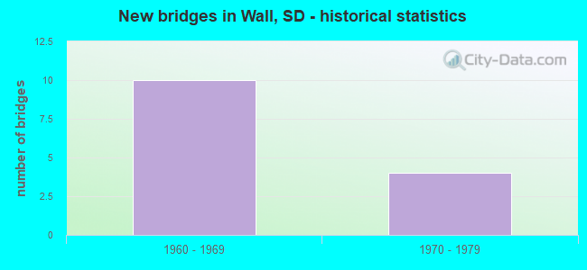
- New bridges - historical statistics
- 101960-1969
- 41970-1979


- Bridge Condition - Deck
- 25.0%Good
- 62.5%Satisfactory
- 12.5%Fair

- Bridge Condition - Superstructure
- 75.0%Satisfactory
- 25.0%Fair

- Bridge Condition - Substructure
- 50.0%Good
- 50.0%Satisfactory
Find on map >> Show street view
Structure Number: 52880346, Location: 1.9 NW W WALL INTERCHANGE (Lat: 44.015703, Lng: -102.287872), Route carried "on" structure: County highway , Year Built: 1968, Status: Open, Structure Length: 12.37m (40.58ft), Average Daily Traffic: 104 (year 2020), Truck Traffic: 3%, Average Future Daily Traffic: 181 (year 2040), Design Load: HS 20, Features Intersected: I090, Facility Carried by Structure: CEDAR BUTTE RD
Minimum Vertical Clearance: 30+ m (98+ ft), Kilometerpoint: 0.000, Lanes on structure: 2, Lanes under structure: 4, Owner: State Highway Agency, Approaching Roadway Width: 9.1m (29.9ft), Skew: 4 degrees, Material/Design: Steel continuous, Design/Construction: Stringer/Multi-beam, Number Of Spans In Main Unit: 4, Length of Maximum Span: 33.8m (110.9ft), Curb-To-Curb Width: 9.1m (29.9ft), Out-to-Out Width: 10.0m (32.8ft)
Condition: Deck: Satisfactory, Superstructure: Satisfactory, Substructure: Satisfactory, Operating Rating: 50.7 metric tons, Method Used To Determine Operating Rating: Load Factor (LF), Inventory Rating: 30.4 metric tons, Method Used To Determine Inventory Rating: Load Factor (LF), Structural Evaluation: Equal to present minimum criteria, Deck Geometry: Equal to present minimum criteria, Underclear: Equal to present minimum criteria, Approach Roadway Alignment: Equal to present minimum criteria, Designated Inspection Frequency: Every 24 months, Inspection Date: October 2021, Deck Structure Type: Concrete Cast-file-Place, Wearing Surface/Protective System: Wearing Surface: Low Slump Concrete
Find on map >> Show street view
Structure Number: 5290036, Location: WEST WALL INTERCHANGE (Lat: 43.994561, Lng: -102.258075), Route carried "on" structure: State highway 240, Year Built: 1968, Status: Open, Structure Length: 12.52m (41.08ft), Average Daily Traffic: 516 (year 2021), Truck Traffic: 3%, Average Future Daily Traffic: 814 (year 2041), Design Load: HS 20, Features Intersected: I090
Minimum Vertical Clearance: 30+ m (98+ ft), Kilometerpoint: 203.292, Lanes on structure: 2, Lanes under structure: 4, Owner: State Highway Agency, Approaching Roadway Width: 13.4m (44.0ft), Skew: 4 degrees, Material/Design: Steel continuous, Design/Construction: Stringer/Multi-beam, Number Of Spans In Main Unit: 4, Length of Maximum Span: 34.3m (112.5ft), Curb-To-Curb Width: 13.4m (44.0ft), Out-to-Out Width: 14.2m (46.6ft)
Condition: Deck: Satisfactory, Superstructure: Satisfactory, Substructure: Satisfactory, Operating Rating: 39.7 metric tons, Method Used To Determine Operating Rating: Load Factor (LF), Inventory Rating: 23.8 metric tons, Method Used To Determine Inventory Rating: Load Factor (LF), Structural Evaluation: Equal to present minimum criteria, Deck Geometry: Superior to present desirable criteria, Underclear: Somewhat better than minimum adequacy, Approach Roadway Alignment: Equal to present minimum criteria, Designated Inspection Frequency: Every 24 months, Inspection Date: October 2021, Deck Structure Type: Concrete Cast-file-Place, Wearing Surface/Protective System: Wearing Surface: Low Slump Concrete
Find on map >> Show street view
Structure Number: 52905364, Location: 0.5 W SD 240 INTERCH (Lat: 43.988014, Lng: -102.247650), Route carried "on" structure: Interstate 90, Year Built: 1968, Status: Open, Structure Length: 5.52m (18.11ft), Average Daily Traffic: 3,825 (year 2021), Truck Traffic: 25%, Average Future Daily Traffic: 5,366 (year 2041), Design Load: HS 20+Mod, Features Intersected: CP/DM&E RR
Minimum Vertical Clearance: 30+ m (98+ ft), Kilometerpoint: 177.913, Lanes on structure: 2, Base Highway Network: Yes, Owner: State Highway Agency, Approaching Roadway Width: 11.6m (38.1ft), Skew: 3 degrees, Material/Design: Steel continuous, Design/Construction: Stringer/Multi-beam, Number Of Spans In Main Unit: 3, Length of Maximum Span: 20.7m (67.9ft), Curb-To-Curb Width: 11.6m (38.1ft), Out-to-Out Width: 12.4m (40.7ft)
Condition: Deck: Good, Superstructure: Satisfactory, Substructure: Satisfactory, Operating Rating: 58.7 metric tons, Method Used To Determine Operating Rating: Load Factor (LF), Inventory Rating: 35.1 metric tons, Method Used To Determine Inventory Rating: Load Factor (LF), Structural Evaluation: Equal to present minimum criteria, Deck Geometry: Equal to present minimum criteria, Underclear: Superior to present desirable criteria, Approach Roadway Alignment: Equal to present desirable criteria, Designated Inspection Frequency: Every 24 months, Inspection Date: July 2021, Deck Structure Type: Concrete Cast-file-Place, Wearing Surface/Protective System: Wearing Surface: Epoxy Overlay, Membrane: Epoxy
Find on map >> Show street view
Structure Number: 52905365, Location: 0.5 W SD 240 INTERCH (Lat: 43.987900, Lng: -102.248067), Route carried "on" structure: Interstate 90, Year Built: 1968, Status: Open, Structure Length: 5.52m (18.11ft), Average Daily Traffic: 3,825 (year 2021), Truck Traffic: 25%, Average Future Daily Traffic: 5,366 (year 2041), Design Load: HS 20+Mod, Features Intersected: CP/DM&E RR
Minimum Vertical Clearance: 30+ m (98+ ft), Kilometerpoint: 177.913, Lanes on structure: 2, Base Highway Network: Yes, Owner: State Highway Agency, Approaching Roadway Width: 11.6m (38.1ft), Skew: 3 degrees, Material/Design: Steel continuous, Design/Construction: Stringer/Multi-beam, Number Of Spans In Main Unit: 3, Length of Maximum Span: 20.7m (67.9ft), Curb-To-Curb Width: 11.6m (38.1ft), Out-to-Out Width: 12.4m (40.7ft)
Condition: Deck: Good, Superstructure: Satisfactory, Substructure: Satisfactory, Operating Rating: 58.7 metric tons, Method Used To Determine Operating Rating: Load Factor (LF), Inventory Rating: 35.1 metric tons, Method Used To Determine Inventory Rating: Load Factor (LF), Structural Evaluation: Equal to present minimum criteria, Deck Geometry: Equal to present minimum criteria, Underclear: Equal to present desirable criteria, Approach Roadway Alignment: Equal to present desirable criteria, Designated Inspection Frequency: Every 24 months, Inspection Date: July 2021, Deck Structure Type: Concrete Cast-file-Place, Wearing Surface/Protective System: Wearing Surface: Epoxy Overlay, Membrane: Epoxy
Find on map >> Show street view
Structure Number: 52910365, Location: SD240 & WALL INTERCHANGE (Lat: 43.986558, Lng: -102.238908), Route carried "on" structure: Interstate 90, Year Built: 1968, Status: Open, Structure Length: 3.84m (12.60ft), Average Daily Traffic: 3,830 (year 2021), Truck Traffic: 24%, Average Future Daily Traffic: 5,373 (year 2041), Design Load: HS 20+Mod, Features Intersected: SD240
Minimum Vertical Clearance: 30+ m (98+ ft), Kilometerpoint: 178.605, Lanes on structure: 2, Lanes under structure: 2, Base Highway Network: Yes, Owner: State Highway Agency, Approaching Roadway Width: 11.6m (38.1ft), Material/Design: Concrete continuous, Design/Construction: Slab, Number Of Spans In Main Unit: 3, Length of Maximum Span: 14.0m (45.9ft), Curb-To-Curb Width: 11.6m (38.1ft), Out-to-Out Width: 12.4m (40.7ft)
Condition: Deck: Satisfactory, Superstructure: Fair, Substructure: Good, Operating Rating: 59.5 metric tons, Method Used To Determine Operating Rating: Load Factor (LF), Inventory Rating: 35.7 metric tons, Method Used To Determine Inventory Rating: Load Factor (LF), Structural Evaluation: Somewhat better than minimum adequacy, Deck Geometry: Equal to present minimum criteria, Underclear: Somewhat better than minimum adequacy, Approach Roadway Alignment: Equal to present desirable criteria, Designated Inspection Frequency: Every 24 months, Inspection Date: July 2021, Deck Structure Type: Concrete Cast-file-Place, Wearing Surface/Protective System: Wearing Surface: Latex Concrete
Find on map >> Show street view
Structure Number: 52910366, Location: SD240 & WALL INTERCHANGE (Lat: 43.986311, Lng: -102.238925), Route carried "on" structure: Interstate 90, Year Built: 1968, Status: Open, Structure Length: 3.84m (12.60ft), Average Daily Traffic: 3,830 (year 2021), Truck Traffic: 24%, Average Future Daily Traffic: 5,373 (year 2041), Design Load: HS 20+Mod, Features Intersected: SD240
Minimum Vertical Clearance: 30+ m (98+ ft), Kilometerpoint: 178.605, Lanes on structure: 2, Lanes under structure: 2, Base Highway Network: Yes, Owner: State Highway Agency, Approaching Roadway Width: 11.6m (38.1ft), Material/Design: Concrete continuous, Design/Construction: Slab, Number Of Spans In Main Unit: 3, Length of Maximum Span: 14.0m (45.9ft), Curb-To-Curb Width: 11.6m (38.1ft), Out-to-Out Width: 12.4m (40.7ft)
Condition: Deck: Satisfactory, Superstructure: Fair, Substructure: Good, Operating Rating: 59.9 metric tons, Method Used To Determine Operating Rating: Load Factor (LF), Inventory Rating: 35.8 metric tons, Method Used To Determine Inventory Rating: Load Factor (LF), Structural Evaluation: Somewhat better than minimum adequacy, Deck Geometry: Equal to present minimum criteria, Underclear: Somewhat better than minimum adequacy, Approach Roadway Alignment: Better than present minimum criteria, Designated Inspection Frequency: Every 24 months, Inspection Date: July 2021, Deck Structure Type: Concrete Cast-file-Place, Wearing Surface/Protective System: Wearing Surface: Latex Concrete
Find on map >> Show street view
Structure Number: 52925365, Location: US 14 & I 90 INTERCHANGE (Lat: 43.985411, Lng: -102.206819), Route carried "on" structure: Ramp Interstate 90, Year Built: 1974, Status: Open, Structure Length: 10.99m (36.06ft), Average Daily Traffic: 6 (year 2020), Truck Traffic: 10%, Average Future Daily Traffic: 8 (year 2040), Design Load: HS 20+Mod, Features Intersected: I090
Minimum Vertical Clearance: 30+ m (98+ ft), Kilometerpoint: 180.584, Lanes on structure: 1, Lanes under structure: 4, Base Highway Network: Yes, Owner: State Highway Agency, Approaching Roadway Width: 11.6m (38.1ft), Skew: 2 degrees, Material/Design: Steel continuous, Design/Construction: Stringer/Multi-beam, Number Of Spans In Main Unit: 4, Length of Maximum Span: 31.1m (102.0ft), Curb-To-Curb Width: 7.3m (24.0ft), Out-to-Out Width: 8.1m (26.6ft)
Condition: Deck: Fair, Superstructure: Satisfactory, Substructure: Good, Operating Rating: 33.1 metric tons, Method Used To Determine Operating Rating: Load Factor (LF), Inventory Rating: 19.9 metric tons, Method Used To Determine Inventory Rating: Load Factor (LF), Structural Evaluation: Somewhat better than minimum adequacy, Deck Geometry: Better than present minimum criteria, Underclear: Somewhat better than minimum adequacy, Approach Roadway Alignment: Somewhat better than minimum adequacy, Designated Inspection Frequency: Every 24 months, Inspection Date: July 2021, Deck Structure Type: Concrete Cast-file-Place, Wearing Surface/Protective System: Wearing Surface: Epoxy Overlay
Find on map >> Show street view
Structure Number: 52926366, Location: US 14 & I 90 INTERCHANGE (Lat: 43.985231, Lng: -102.206553), Route carried "on" structure: US 14, Year Built: 1974, Status: Open, Structure Length: 11.05m (36.25ft), Average Daily Traffic: 516 (year 2021), Truck Traffic: 13%, Average Future Daily Traffic: 814 (year 2041), Design Load: HS 20+Mod, Features Intersected: I090
Minimum Vertical Clearance: 30+ m (98+ ft), Kilometerpoint: 181.791, Lanes on structure: 2, Lanes under structure: 4, Owner: State Highway Agency, Approaching Roadway Width: 11.6m (38.1ft), Skew: 2 degrees, Material/Design: Steel continuous, Design/Construction: Stringer/Multi-beam, Number Of Spans In Main Unit: 4, Length of Maximum Span: 30.2m (99.1ft), Curb-To-Curb Width: 12.2m (40.0ft), Out-to-Out Width: 13.0m (42.7ft)
Condition: Deck: Satisfactory, Superstructure: Satisfactory, Substructure: Good, Operating Rating: 58.1 metric tons, Method Used To Determine Operating Rating: Load Factor (LF), Inventory Rating: 34.8 metric tons, Method Used To Determine Inventory Rating: Load Factor (LF), Structural Evaluation: Equal to present minimum criteria, Deck Geometry: Better than present minimum criteria, Underclear: Superior to present desirable criteria, Approach Roadway Alignment: Equal to present minimum criteria, Designated Inspection Frequency: Every 24 months, Inspection Date: July 2021, Deck Structure Type: Concrete Cast-file-Place, Wearing Surface/Protective System: Wearing Surface: Epoxy Overlay, Membrane: Epoxy
Find on map >> Show street view
Structure Number: 52880346, Location: 1.9 NW W WALL INTERCHANGE (Lat: 44.015703, Lng: -102.287872), Route carried "under" structure: Interstate 90, Year Built: 1968, Structure Length: 0. m, Average Daily Traffic: 7,370 (year 2020), Truck Traffic: 22%, Features Intersected: I090, Facility Carried by Structure: CEDAR BUTTE RD
Minimum Vertical Clearance: 5.26m (17.26ft), Kilometerpoint: 173.568, Lanes on structure: 2, Lanes under structure: 4, Material/Design: Steel continuous, Design/Construction: Stringer/Multi-beam, Length of Maximum Span: 33.8m (110.9ft)
Find on map >> Show street view
Structure Number: 5290036, Location: WEST WALL INTERCHANGE (Lat: 43.994561, Lng: -102.258075), Route carried "under" structure: Interstate 90, Year Built: 1968, Structure Length: 0. m, Average Daily Traffic: 7,350 (year 2020), Truck Traffic: 22%, Features Intersected: I090, Facility Carried by Structure: SD240
Minimum Vertical Clearance: 5.11m (16.77ft), Kilometerpoint: 176.738, Lanes on structure: 2, Lanes under structure: 4, Material/Design: Steel continuous, Design/Construction: Stringer/Multi-beam, Length of Maximum Span: 34.3m (112.5ft)
Find on map >> Show street view
Structure Number: 52910365, Location: SD240 & WALL INTERCHANGE (Lat: 43.986558, Lng: -102.238908), Route carried "under" structure: State highway 240, Year Built: 1968, Structure Length: 0. m, Average Daily Traffic: 4,287 (year 2021), Truck Traffic: 7%, Features Intersected: SD240, Facility Carried by Structure: I090 W
Minimum Vertical Clearance: 4.55m (14.93ft), Kilometerpoint: 205.143, Lanes on structure: 2, Lanes under structure: 2, Material/Design: Concrete continuous, Design/Construction: Slab, Length of Maximum Span: 14.0m (45.9ft)
Find on map >> Show street view
Structure Number: 52910366, Location: SD240 & WALL INTERCHANGE (Lat: 43.986311, Lng: -102.238925), Route carried "under" structure: State highway 240, Year Built: 1968, Structure Length: 0. m, Average Daily Traffic: 1,293 (year 2021), Truck Traffic: 4%, Features Intersected: SD240, Facility Carried by Structure: I090 E
Minimum Vertical Clearance: 4.55m (14.93ft), Kilometerpoint: 205.191, Lanes on structure: 2, Lanes under structure: 2, Material/Design: Concrete continuous, Design/Construction: Slab, Length of Maximum Span: 14.0m (45.9ft)
Find on map >> Show street view
Structure Number: 52925365, Location: US 14 & I 90 INTERCHANGE (Lat: 43.985411, Lng: -102.206819), Route carried "under" structure: Interstate 90, Year Built: 1974, Structure Length: 0. m, Average Daily Traffic: 6,270 (year 2020), Truck Traffic: 29%, Features Intersected: I090
Minimum Vertical Clearance: 5.76m (18.90ft), Kilometerpoint: 181.228, Lanes on structure: 1, Lanes under structure: 4, Material/Design: Steel continuous, Design/Construction: Stringer/Multi-beam, Length of Maximum Span: 31.1m (102.0ft)
Find on map >> Show street view
Structure Number: 52926366, Location: US 14 & I 90 INTERCHANGE (Lat: 43.985231, Lng: -102.206553), Route carried "under" structure: Interstate 90, Year Built: 1974, Structure Length: 0. m, Average Daily Traffic: 6,270 (year 2020), Truck Traffic: 29%, Features Intersected: I090, Facility Carried by Structure: US014 E
Minimum Vertical Clearance: 6.38m (20.93ft), Kilometerpoint: 181.277, Lanes on structure: 2, Lanes under structure: 4, Material/Design: Steel continuous, Design/Construction: Stringer/Multi-beam, Length of Maximum Span: 30.2m (99.1ft)