Bridge Statistics for Walnut Creek, North Carolina (NC)
Condition, Traffic, Stress, Structural Evaluation, Project Costs
- National Bridge Inventory (NBI) Statistics
- 12Number of bridges
- 138ft / 41.8mTotal length
- 124,930Total average daily traffic
- 15,355Total average daily truck traffic
- National Bridge Inventory (NBI) Registered Bridges for Walnut Creek
- No street view available for this location
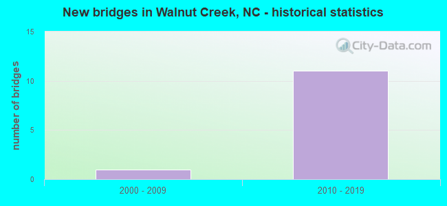
- New bridges - historical statistics
- 12000-2009
- 112010-2019


- Bridge Condition - Deck
- 16.7%Excellent
- 33.3%Very good
- 50.0%Good

- Bridge Condition - Superstructure
- 16.7%Excellent
- 33.3%Very good
- 50.0%Good

- Bridge Condition - Substructure
- 16.7%Excellent
- 33.3%Very good
- 33.3%Good
- 16.7%Satisfactory
Find on map >> Show street view
Structure Number: 1070207, Location: 0.7 MI. E. OF JCT. SR1731 (Lat: 35.303961, Lng: -77.836369), Route carried "on" structure: US 70, Year Built: 2015, Status: Open, Structure Length: 7.19m (23.59ft), Average Daily Traffic: 57,500 (year 2018), Truck Traffic: 14%, Average Future Daily Traffic: 115,000 (year 2025), Design Load: HL 93, Features Intersected: US70BYP.
Minimum Vertical Clearance: 30+ m (98+ ft), Kilometerpoint: 0.000, Lanes on structure: 3, Lanes under structure: 5, Base Highway Network: Yes (Inventory Route: 2, Subroute: 70), Owner: State Highway Agency, Approaching Roadway Width: 19.2m (63.0ft), Skew: 39 degrees, Material/Design: Prestressed concrete continuous, Design/Construction: Stringer/Multi-beam, Number Of Spans In Main Unit: 2, Number Of Approach Spans: 1, Length of Maximum Span: 37.7m (123.7ft), Curb-To-Curb Width: 19.5m (64.0ft), Out-to-Out Width: 21.2m (69.6ft)
Condition: Deck: Very good, Superstructure: Very good, Substructure: Very good, Operating Rating: 70.7 metric tons, Method Used To Determine Operating Rating: Load and Resistance Factor (LRFR), Inventory Rating: 48.0 metric tons, Method Used To Determine Inventory Rating: Load and Resistance Factor (LRFR), Structural Evaluation: Equal to present desirable criteria, Deck Geometry: Superior to present desirable criteria, Underclear: Somewhat better than minimum adequacy, Approach Roadway Alignment: Equal to present desirable criteria, Designated Inspection Frequency: Every 24 months, Inspection Date: June 2021, Deck Structure Type: Concrete Cast-file-Place, Wearing Surface/Protective System: Wearing Surface: Monolithic Concrete
Find on map >> Show street view
Structure Number: 1910004, Location: 0.7MI.W.JCT.SR1731 (Lat: 35.281714, Lng: -77.868489), Route carried "on" structure: State highway 1730, Year Built: 2000, Status: Open, Structure Length: 4.93m (16.17ft), Average Daily Traffic: 1,500 (year 2016), Truck Traffic: 6%, Average Future Daily Traffic: 3,000 (year 2040), Design Load: HS 20+Mod, Features Intersected: WALNUT CREEK
Minimum Vertical Clearance: 30+ m (98+ ft), Kilometerpoint: 0.000, Lanes on structure: 2, Owner: State Highway Agency, Approaching Roadway Width: 6.7m (22.0ft), Material/Design: Prestressed concrete, Design/Construction: Slab, Number Of Spans In Main Unit: 3, Length of Maximum Span: 17.9m (58.7ft), Curb-To-Curb Width: 8.2m (26.9ft), Out-to-Out Width: 9.1m (29.9ft)
Condition: Deck: Good, Superstructure: Good, Substructure: Satisfactory, Channel: Good, Operating Rating: 70.7 metric tons, Method Used To Determine Operating Rating: Load Factor (LF), Inventory Rating: 41.7 metric tons, Method Used To Determine Inventory Rating: Load Factor (LF), Structural Evaluation: Equal to present minimum criteria, Deck Geometry: Meets minimum limits, Waterway Adequacy: Better than present minimum criteria, Approach Roadway Alignment: Equal to present desirable criteria, Designated Inspection Frequency: Every 24 months, Underwater Inspection Frequency: Every 60 months, Inspection Date: October 2021, Underwater Inspection Date: October 2020, Deck Structure Type: Concrete Precast Panels, Wearing Surface/Protective System: Wearing Surface: Bituminous
Find on map >> Show street view
Structure Number: 1910015, Location: 1.0 MI N JCT SR1003 (Lat: 35.358931, Lng: -77.846211), Route carried "on" structure: State highway 1719, Year Built: 2019, Status: Open, Structure Length: 2.65m (8.69ft), Average Daily Traffic: 630 (year 2016), Truck Traffic: 6%, Average Future Daily Traffic: 1,260 (year 2040), Design Load: HL 93, Features Intersected: BEAR CREEK
Minimum Vertical Clearance: 30+ m (98+ ft), Kilometerpoint: 0.000, Lanes on structure: 2, Owner: State Highway Agency, Approaching Roadway Width: 9.4m (30.8ft), Material/Design: Prestressed concrete, Design/Construction: Slab, Number Of Spans In Main Unit: 2, Length of Maximum Span: 16.4m (53.8ft), Curb-To-Curb Width: 9.1m (29.9ft), Out-to-Out Width: 10.0m (32.8ft)
Condition: Deck: Excellent, Superstructure: Excellent, Substructure: Excellent, Channel: Good, Operating Rating: 49.8 metric tons, Method Used To Determine Operating Rating: Load and Resistance Factor (LRFR), Inventory Rating: 38.1 metric tons, Method Used To Determine Inventory Rating: Load and Resistance Factor (LRFR), Structural Evaluation: Superior to present desirable criteria, Deck Geometry: Equal to present minimum criteria, Waterway Adequacy: Better than present minimum criteria, Approach Roadway Alignment: Equal to present desirable criteria, Designated Inspection Frequency: Every 24 months, Inspection Date: March 2020, Deck Structure Type: Concrete Precast Panels, Wearing Surface/Protective System: Wearing Surface: Bituminous, Deck Protection: Epoxy Coated Reinforcing
Find on map >> Show street view
Structure Number: 191012, Location: 1.0 MI S. JCT US70 (Lat: 35.316181, Lng: -77.883308), Route carried "on" structure: State highway 1728, Year Built: 2012, Status: Open, Structure Length: 3.96m (12.99ft), Average Daily Traffic: 1,700 (year 2016), Truck Traffic: 6%, Average Future Daily Traffic: 3,400 (year 2040), Design Load: HL 93, Features Intersected: WALNUT CREEK
Minimum Vertical Clearance: 30+ m (98+ ft), Kilometerpoint: 0.000, Lanes on structure: 2, Owner: State Highway Agency, Approaching Roadway Width: 9.7m (31.8ft), Material/Design: Prestressed concrete, Design/Construction: Slab, Number Of Spans In Main Unit: 3, Length of Maximum Span: 14.9m (48.9ft), Curb-To-Curb Width: 9.0m (29.5ft), Out-to-Out Width: 10.0m (32.8ft)
Condition: Deck: Very good, Superstructure: Very good, Substructure: Very good, Channel: Good, Operating Rating: 69.8 metric tons, Method Used To Determine Operating Rating: Load and Resistance Factor (LRFR), Inventory Rating: 52.6 metric tons, Method Used To Determine Inventory Rating: Load and Resistance Factor (LRFR), Structural Evaluation: Equal to present desirable criteria, Deck Geometry: Somewhat better than minimum adequacy, Waterway Adequacy: Better than present minimum criteria, Approach Roadway Alignment: Equal to present desirable criteria, Designated Inspection Frequency: Every 24 months, Underwater Inspection Frequency: Every 60 months, Inspection Date: July 2020, Underwater Inspection Date: September 2019, Deck Structure Type: Concrete Precast Panels, Wearing Surface/Protective System: Wearing Surface: Bituminous, Deck Protection: Epoxy Coated Reinforcing
Find on map >> Show street view
Structure Number: 1910383, Location: 0.9 MI. E. JCT. SR1719 (Lat: 35.342214, Lng: -77.845236), Route carried "on" structure: Bypass US 70, Year Built: 2016, Status: Open, Structure Length: 11.52m (37.80ft), Average Daily Traffic: 6,500 (year 2018), Truck Traffic: 14%, Average Future Daily Traffic: 13,000 (year 2040), Design Load: HL 93, Features Intersected: SR1003, NSRR
Minimum Vertical Clearance: 30+ m (98+ ft), Kilometerpoint: 111.832, Lanes on structure: 2, Lanes under structure: 2, Base Highway Network: Yes (Inventory Route: 2, Subroute: 70), Owner: State Highway Agency, Approaching Roadway Width: 12.1m (39.7ft), Skew: 14 degrees, Material/Design: Prestressed concrete continuous, Design/Construction: Stringer/Multi-beam, Number Of Spans In Main Unit: 4, Number Of Approach Spans: 2, Length of Maximum Span: 31.0m (101.7ft), Curb-To-Curb Width: 12.1m (39.7ft), Out-to-Out Width: 13.1m (43.0ft)
Condition: Deck: Good, Superstructure: Good, Substructure: Good, Operating Rating: 58.9 metric tons, Method Used To Determine Operating Rating: Load and Resistance Factor (LRFR), Inventory Rating: 45.3 metric tons, Method Used To Determine Inventory Rating: Load and Resistance Factor (LRFR), Structural Evaluation: Better than present minimum criteria, Deck Geometry: Better than present minimum criteria, Underclear: Equal to present minimum criteria, Approach Roadway Alignment: Equal to present desirable criteria, Designated Inspection Frequency: Every 24 months, Inspection Date: August 2020, Deck Structure Type: Concrete Cast-file-Place, Wearing Surface/Protective System: Wearing Surface: Monolithic Concrete, Deck Protection: Epoxy Coated Reinforcing
Find on map >> Show street view
Structure Number: 1910384, Location: 0.9 MI. E. JCT SR1719 (Lat: 35.342375, Lng: -77.845522), Route carried "on" structure: Bypass US 70, Year Built: 2016, Status: Open, Structure Length: 11.52m (37.80ft), Average Daily Traffic: 6,500 (year 2018), Truck Traffic: 14%, Average Future Daily Traffic: 13,000 (year 2040), Design Load: HL 93, Features Intersected: SR1003, RR
Minimum Vertical Clearance: 30+ m (98+ ft), Kilometerpoint: 111.832, Lanes on structure: 2, Lanes under structure: 2, Base Highway Network: Yes (Inventory Route: 2, Subroute: 70), Owner: State Highway Agency, Approaching Roadway Width: 12.8m (42.0ft), Skew: 14 degrees, Material/Design: Prestressed concrete continuous, Design/Construction: Stringer/Multi-beam, Number Of Spans In Main Unit: 4, Number Of Approach Spans: 2, Length of Maximum Span: 31.0m (101.7ft), Curb-To-Curb Width: 12.1m (39.7ft), Out-to-Out Width: 13.1m (43.0ft)
Condition: Deck: Good, Superstructure: Good, Substructure: Good, Operating Rating: 58.9 metric tons, Method Used To Determine Operating Rating: Load and Resistance Factor (LRFR), Inventory Rating: 45.3 metric tons, Method Used To Determine Inventory Rating: Load and Resistance Factor (LRFR), Structural Evaluation: Better than present minimum criteria, Deck Geometry: Better than present minimum criteria, Underclear: Superior to present desirable criteria, Approach Roadway Alignment: Equal to present desirable criteria, Designated Inspection Frequency: Every 24 months, Inspection Date: August 2020, Deck Structure Type: Concrete Cast-file-Place, Wearing Surface/Protective System: Wearing Surface: Monolithic Concrete, Deck Protection: Epoxy Coated Reinforcing
Find on map >> Show street view
Structure Number: 1070191, Location: 3.8 MI. W. JCT. US258 (Lat: 35.303961, Lng: -77.888689), Route carried "under" structure: US 70, Year Built: 2012, Structure Length: 0. m, Average Daily Traffic: 12,250 (year 2019), Truck Traffic: 14%, Features Intersected: NC148W.RAMP
Minimum Vertical Clearance: 6.78m (22.24ft), Kilometerpoint: 0.000, Lanes on structure: 1, Lanes under structure: 3, Material/Design: Prestressed concrete continuous, Design/Construction: Stringer/Multi-beam, Length of Maximum Span: 33.8m (110.9ft)
Find on map >> Show street view
Structure Number: 1070191, Location: 3.8 MI. W. JCT. US258 (Lat: 35.303961, Lng: -77.888689), Route carried "under" structure: US 70, Year Built: 2012, Structure Length: 0. m, Average Daily Traffic: 12,250 (year 2019), Truck Traffic: 14%, Features Intersected: NC148W.RAMP
Minimum Vertical Clearance: 6.01m (19.72ft), Kilometerpoint: 0.000, Lanes on structure: 1, Lanes under structure: 2, Material/Design: Prestressed concrete continuous, Design/Construction: Stringer/Multi-beam, Length of Maximum Span: 33.8m (110.9ft)
Find on map >> Show street view
Structure Number: 1070207, Location: 0.7 MI. E. OF JCT. SR1731 (Lat: 35.303961, Lng: -77.836369), Route carried "under" structure: Bypass US 70, Year Built: 2015, Structure Length: 0. m, Average Daily Traffic: 11,750 (year 2019), Truck Traffic: 7%, Features Intersected: US70
Minimum Vertical Clearance: 5.91m (19.39ft), Kilometerpoint: 0.000, Lanes on structure: 3, Lanes under structure: 2, Material/Design: Prestressed concrete continuous, Design/Construction: Stringer/Multi-beam, Length of Maximum Span: 37.7m (123.7ft)
Find on map >> Show street view
Structure Number: 1070207, Location: 0.7 MI. E. OF JCT. SR1731 (Lat: 35.303961, Lng: -77.836369), Route carried "under" structure: Bypass US 70, Year Built: 2015, Structure Length: 0. m, Average Daily Traffic: 11,750 (year 2019), Truck Traffic: 7%, Features Intersected: US70
Minimum Vertical Clearance: 6.65m (21.82ft), Kilometerpoint: 0.000, Lanes on structure: 3, Lanes under structure: 3, Material/Design: Prestressed concrete continuous, Design/Construction: Stringer/Multi-beam, Length of Maximum Span: 37.7m (123.7ft)
Find on map >> Show street view
Structure Number: 1910383, Location: 0.9 MI. E. JCT. SR1719 (Lat: 35.342214, Lng: -77.845236), Route carried "under" structure: State highway 1003, Year Built: 2016, Structure Length: 0. m, Average Daily Traffic: 1,300 (year 2018), Truck Traffic: 7%, Features Intersected: US70W.BYP
Minimum Vertical Clearance: 7.42m (24.34ft), Kilometerpoint: 111.832, Lanes on structure: 2, Lanes under structure: 2, Material/Design: Prestressed concrete continuous, Design/Construction: Stringer/Multi-beam, Length of Maximum Span: 31.0m (101.7ft)
Find on map >> Show street view
Structure Number: 1910384, Location: 0.9 MI. E. JCT SR1719 (Lat: 35.342375, Lng: -77.845522), Route carried "under" structure: State highway 1003, Year Built: 2016, Structure Length: 0. m, Average Daily Traffic: 1,300 (year 2018), Truck Traffic: 7%, Features Intersected: US70E.BYP
Minimum Vertical Clearance: 7.61m (24.97ft), Kilometerpoint: 111.832, Lanes on structure: 2, Lanes under structure: 2, Material/Design: Prestressed concrete continuous, Design/Construction: Stringer/Multi-beam, Length of Maximum Span: 31.0m (101.7ft)