Bridge Statistics for Wampum, Pennsylvania (PA)
Condition, Traffic, Stress, Structural Evaluation, Project Costs
- National Bridge Inventory (NBI) Statistics
- 19Number of bridges
- 138ft / 42.4mTotal length
- $1,480,000Total costs
- 84,513Total average daily traffic
- 8,753Total average daily truck traffic
- National Bridge Inventory (NBI) Registered Bridges for Wampum
- No street view available for this location
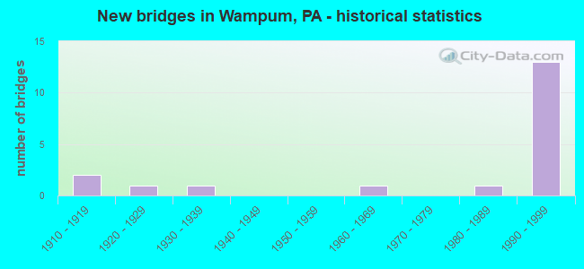
- New bridges - historical statistics
- 21910-1919
- 11920-1929
- 11930-1939
- 11960-1969
- 11980-1989
- 131990-1999


- Bridge Condition - Deck
- 80.0%Good
- 10.0%Fair
- 10.0%Poor

- Bridge Condition - Superstructure
- 66.7%Good
- 25.0%Fair
- 8.3%Poor

- Bridge Condition - Substructure
- 58.3%Good
- 8.3%Satisfactory
- 25.0%Fair
- 8.3%Poor

- Bridge Condition - Channel
- 14.3%Satisfactory
- 28.6%Fair
- 57.1%Poor
Find on map >> Show street view
Structure Number: 1507, Location: 564'NORTH OF SR 0136 (Lat: 40.207900, Lng: -79.857953), Route carried "on" structure: State highway , Year Built: 1926, Status: Open, Structure Length: 0.64m (2.10ft), Average Daily Traffic: 236 (year 2020), Truck Traffic: 6%, Average Future Daily Traffic: 989 (year 2032), Design Load: HS 20, Features Intersected: BR.BECKETS RUN, Facility Carried by Structure: ELLA HOLLOW RD
Minimum Vertical Clearance: 30+ m (98+ ft), Kilometerpoint: 0.000, Lanes on structure: 2, Owner: State Highway Agency, Approaching Roadway Width: 7.0m (23.0ft), Skew: 4 degrees, Material/Design: Steel, Design/Construction: Stringer/Multi-beam, Number Of Spans In Main Unit: 1, Length of Maximum Span: 5.8m (19.0ft), Curb-To-Curb Width: 4.9m (16.1ft), Out-to-Out Width: 6.9m (22.6ft)
Condition: Deck: Poor, Superstructure: Poor, Substructure: Poor, Channel: Poor, Operating Rating: 49.0 metric tons, Method Used To Determine Operating Rating: Field evaluation and documented engineering judgment, Inventory Rating: 32.7 metric tons, Method Used To Determine Inventory Rating: Field evaluation and documented engineering judgment, Structural Evaluation: Meets minimum limits, Deck Geometry: High priority of replacement, Waterway Adequacy: Better than present minimum criteria, Approach Roadway Alignment: Meets minimum limits, Length Of Structure Improvement: 0.60m (1.97ft), Designated Inspection Frequency: Every 24 months, Inspection Date: January 2020, Bridge Improvement Cost: $14,000, Roadway Improvement Cost: $40,000, Total Project Cost: $184,000, Deck Structure Type: Concrete Cast-file-Place, Wearing Surface/Protective System: Wearing Surface: Bituminous
Find on map >> Show street view
Structure Number: 1511, Location: .2 MI SW OF SR 2017 (Lat: 40.269969, Lng: -79.800011), Route carried "on" structure: State highway , Year Built: 1936, Status: Open, Structure Length: 0.76m (2.49ft), Average Daily Traffic: 558 (year 2022), Truck Traffic: 9%, Average Future Daily Traffic: 1,078 (year 2032), Design Load: HS 20, Features Intersected: BOYDS HOLLOW RUN, Facility Carried by Structure: BOYDS HOLLOW ROAD
Minimum Vertical Clearance: 30+ m (98+ ft), Kilometerpoint: 0.000, Lanes on structure: 2, Owner: State Highway Agency, Approaching Roadway Width: 5.8m (19.0ft), Skew: 6 degrees, Material/Design: Steel, Design/Construction: Stringer/Multi-beam, Number Of Spans In Main Unit: 1, Length of Maximum Span: 6.1m (20.0ft), Curb-To-Curb Width: 7.6m (24.9ft), Out-to-Out Width: 8.2m (26.9ft)
Condition: Deck: Fair, Superstructure: Fair, Substructure: Fair, Channel: Poor, Operating Rating: 49.0 metric tons, Method Used To Determine Operating Rating: Field evaluation and documented engineering judgment, Inventory Rating: 32.7 metric tons, Method Used To Determine Inventory Rating: Field evaluation and documented engineering judgment, Structural Evaluation: Somewhat better than minimum adequacy, Deck Geometry: Meets minimum limits, Waterway Adequacy: Better than present minimum criteria, Approach Roadway Alignment: Equal to present minimum criteria, Length Of Structure Improvement: 0.70m (2.30ft), Designated Inspection Frequency: Every 24 months, Inspection Date: January 2020, Bridge Improvement Cost: $17,000, Roadway Improvement Cost: $50,000, Total Project Cost: $231,000, Deck Structure Type: Concrete Cast-file-Place, Wearing Surface/Protective System: Wearing Surface: Bituminous
Find on map >> Show street view
Structure Number: 3806, Location: NEW BEAVER BOROUGH (Lat: 40.862303, Lng: -80.368711), Route carried "on" structure: Other road 376, Year Built: 1992, Status: Open, Structure Length: 4.08m (13.39ft), Average Daily Traffic: 183 (year 1995), Truck Traffic: 10%, Average Future Daily Traffic: 12,000 (year 2030), Design Load: HS 25 or greater, Features Intersected: T-303 (Edwards Rd)
Minimum Vertical Clearance: 30+ m (98+ ft), Kilometerpoint: 0.000, Lanes on structure: 2, Lanes under structure: 2, Base Highway Network: Yes, Toll: On toll road, Owner: State Toll Authority, Approaching Roadway Width: 12.8m (42.0ft), Skew: 14 degrees, Material/Design: Steel, Design/Construction: Stringer/Multi-beam, Number Of Spans In Main Unit: 1, Length of Maximum Span: 39.0m (128.0ft), Curb or Sidewalk Widths: Left: 0.2m (0.7ft), Right: 0.2m (0.7ft), Curb-To-Curb Width: 12.8m (42.0ft), Out-to-Out Width: 13.9m (45.6ft)
Condition: Deck: Good, Superstructure: Good, Substructure: Good, Inventory Rating: 67.1 metric tons, Method Used To Determine Inventory Rating: Load Factor (LF), Structural Evaluation: Better than present minimum criteria, Deck Geometry: Equal to present desirable criteria, Underclear: Equal to present minimum criteria, Approach Roadway Alignment: Equal to present desirable criteria, Designated Inspection Frequency: Every 48 months, Inspection Date: September 2019, Deck Structure Type: Concrete Cast-file-Place, Wearing Surface/Protective System: Wearing Surface: Monolithic Concrete, Deck Protection: Epoxy Coated Reinforcing
Find on map >> Show street view
Structure Number: 3807, Location: NEW BEAVER BORO (Lat: 40.862464, Lng: -80.368372), Route carried "on" structure: Other road 376, Year Built: 1992, Status: Open, Structure Length: 3.35m (10.99ft), Average Daily Traffic: 171 (year 1995), Truck Traffic: 9%, Average Future Daily Traffic: 260 (year 2030), Design Load: HS 25 or greater, Features Intersected: T-303 (Edwards Rd)
Minimum Vertical Clearance: 30+ m (98+ ft), Kilometerpoint: 0.000, Lanes on structure: 2, Lanes under structure: 2, Base Highway Network: Yes, Toll: On toll road, Owner: State Toll Authority, Approaching Roadway Width: 12.8m (42.0ft), Skew: 13 degrees, Material/Design: Steel, Design/Construction: Stringer/Multi-beam, Number Of Spans In Main Unit: 1, Length of Maximum Span: 31.7m (104.0ft), Curb or Sidewalk Widths: Left: 0.2m (0.7ft), Right: 0.2m (0.7ft), Curb-To-Curb Width: 12.8m (42.0ft), Out-to-Out Width: 13.9m (45.6ft)
Condition: Deck: Good, Superstructure: Good, Substructure: Good, Operating Rating: 86.2 metric tons, Method Used To Determine Operating Rating: Load Factor (LF), Inventory Rating: 51.7 metric tons, Method Used To Determine Inventory Rating: Load Factor (LF), Structural Evaluation: Better than present minimum criteria, Deck Geometry: Equal to present desirable criteria, Underclear: Somewhat better than minimum adequacy, Approach Roadway Alignment: Equal to present desirable criteria, Designated Inspection Frequency: Every 48 months, Inspection Date: September 2019, Deck Structure Type: Concrete Cast-file-Place, Wearing Surface/Protective System: Wearing Surface: Monolithic Concrete, Deck Protection: Epoxy Coated Reinforcing
Find on map >> Show street view
Structure Number: 1505, Location: SPRINGFIELD MALL 34G06 (Lat: 39.916239, Lng: -75.362161), Route carried "on" structure: Interstate 476, Year Built: 1990, Status: Open, Structure Length: 12.68m (41.60ft), Average Daily Traffic: 43,318 (year 2021), Truck Traffic: 9%, Average Future Daily Traffic: 59,107 (year 2032), Design Load: HS 25 or greater, Features Intersected: SEPTA(P&W);TRIB.CRUM CK., Facility Carried by Structure: MID-COUNTY EXWY.NB
Minimum Vertical Clearance: 30+ m (98+ ft), Kilometerpoint: 4.738, Lanes on structure: 3, Base Highway Network: Yes, Owner: State Highway Agency, Approaching Roadway Width: 20.7m (67.9ft), Skew: 12 degrees, Material/Design: Prestressed concrete, Design/Construction: Stringer/Multi-beam, Number Of Spans In Main Unit: 4, Length of Maximum Span: 38.1m (125.0ft), Curb or Sidewalk Widths: Left: 0.2m (0.7ft), Right: 0.2m (0.7ft), Curb-To-Curb Width: 20.6m (67.6ft), Out-to-Out Width: 21.9m (71.9ft)
Condition: Deck: Good, Superstructure: Good, Substructure: Good, Channel: Fair, Operating Rating: 69.9 metric tons, Method Used To Determine Operating Rating: Load Factor (LF), Inventory Rating: 26.3 metric tons, Method Used To Determine Inventory Rating: Load Factor (LF), Structural Evaluation: Equal to present minimum criteria, Deck Geometry: Superior to present desirable criteria, Underclear: High priority of corrective action, Waterway Adequacy: Superior to present desirable criteria, Approach Roadway Alignment: Equal to present desirable criteria, Length Of Structure Improvement: 13.60m (44.62ft), Designated Inspection Frequency: Every 24 months, Inspection Date: December 2019, Deck Structure Type: Concrete Cast-file-Place, Wearing Surface/Protective System: Wearing Surface: Monolithic Concrete, Deck Protection: Epoxy Coated Reinforcing
Find on map >> Show street view
Structure Number: 22446, Location: 0.75 MI.S.W.OF INTER W/18 (Lat: 40.874353, Lng: -80.351194), Route carried "on" structure: State highway , Year Built: 1911, Status: Open, Structure Length: 0.64m (2.10ft), Average Daily Traffic: 81 (year 2020), Truck Traffic: 5%, Average Future Daily Traffic: 85 (year 2038), Design Load: HS 20, Features Intersected: WAMPUM RUN, Facility Carried by Structure: DARLINGTON RD
Minimum Vertical Clearance: 30+ m (98+ ft), Kilometerpoint: 1.839, Lanes on structure: 1, Owner: State Highway Agency, Approaching Roadway Width: 4.3m (14.1ft), Skew: 2 degrees, Material/Design: Concrete, Design/Construction: Arch - Deck, Number Of Spans In Main Unit: 1, Length of Maximum Span: 5.5m (18.0ft), Curb or Sidewalk Widths: Left: 0.2m (0.7ft), Right: 0.1m (0.3ft), Curb-To-Curb Width: 4.7m (15.4ft), Out-to-Out Width: 5.3m (17.4ft)
Condition: Superstructure: Fair, Substructure: Fair, Channel: Satisfactory, Operating Rating: 49.0 metric tons, Method Used To Determine Operating Rating: Field evaluation and documented engineering judgment, Inventory Rating: 32.7 metric tons, Method Used To Determine Inventory Rating: Field evaluation and documented engineering judgment, Structural Evaluation: Somewhat better than minimum adequacy, Deck Geometry: Better than present minimum criteria, Waterway Adequacy: Better than present minimum criteria, Approach Roadway Alignment: Equal to present desirable criteria, Length Of Structure Improvement: 0.80m (2.62ft), Designated Inspection Frequency: Every 24 months, Inspection Date: January 2020, Bridge Improvement Cost: $3,000, Roadway Improvement Cost: $12,000, Total Project Cost: $42,000
Find on map >> Show street view
Structure Number: 22447, Location: 0.5 MI.S.W.OF INTER W/18 (Lat: 40.877361, Lng: -80.345497), Route carried "on" structure: State highway , Year Built: 1912, Status: Open, Structure Length: 1.46m (4.79ft), Average Daily Traffic: 81 (year 2020), Truck Traffic: 5%, Average Future Daily Traffic: 85 (year 2038), Design Load: HS 20, Features Intersected: WAMPUM RUN, Facility Carried by Structure: DARLINGTON RD
Minimum Vertical Clearance: 30+ m (98+ ft), Kilometerpoint: 2.519, Lanes on structure: 2, Owner: State Highway Agency, Approaching Roadway Width: 4.9m (16.1ft), Skew: 4 degrees, Material/Design: Concrete, Design/Construction: Arch - Deck, Number Of Spans In Main Unit: 1, Length of Maximum Span: 9.4m (30.8ft), Curb-To-Curb Width: 5.2m (17.1ft), Out-to-Out Width: 5.8m (19.0ft)
Condition: Superstructure: Fair, Substructure: Fair, Channel: Poor, Operating Rating: 49.0 metric tons, Method Used To Determine Operating Rating: Field evaluation and documented engineering judgment, Inventory Rating: 32.7 metric tons, Method Used To Determine Inventory Rating: Field evaluation and documented engineering judgment, Structural Evaluation: Somewhat better than minimum adequacy, Deck Geometry: High priority of corrective action, Waterway Adequacy: Equal to present desirable criteria, Approach Roadway Alignment: Equal to present desirable criteria, Length Of Structure Improvement: 1.50m (4.92ft), Designated Inspection Frequency: Every 24 months, Inspection Date: January 2020, Bridge Improvement Cost: $28,000, Roadway Improvement Cost: $81,000, Total Project Cost: $372,000
Find on map >> Show street view
Structure Number: 22448, Location: 0.5 MI.S.W.OF INTER W/18 (Lat: 40.878494, Lng: -80.341942), Route carried "on" structure: State highway , Year Built: 1988, Status: Open, Structure Length: 0.73m (2.40ft), Average Daily Traffic: 81 (year 2020), Truck Traffic: 5%, Average Future Daily Traffic: 85 (year 2032), Design Load: HS 20, Features Intersected: WAMPUM RUN, Facility Carried by Structure: DARLINGTON ROAD
Minimum Vertical Clearance: 30+ m (98+ ft), Kilometerpoint: 2.519, Lanes on structure: 2, Owner: State Highway Agency, Approaching Roadway Width: 7.3m (24.0ft), Skew: 2 degrees, Material/Design: Steel, Design/Construction: Culvert, Number Of Spans In Main Unit: 1, Length of Maximum Span: 4.6m (15.1ft)
Condition: Channel: Fair, Culverts: Good, Operating Rating: 49.0 metric tons, Method Used To Determine Operating Rating: Field evaluation and documented engineering judgment, Inventory Rating: 32.7 metric tons, Method Used To Determine Inventory Rating: Field evaluation and documented engineering judgment, Structural Evaluation: Better than present minimum criteria, Waterway Adequacy: Superior to present desirable criteria, Approach Roadway Alignment: Equal to present desirable criteria, Length Of Structure Improvement: 1.40m (4.59ft), Designated Inspection Frequency: Every 24 months, Inspection Date: January 2020
Find on map >> Show street view
Structure Number: 22486, Location: NEW BEAVER BOROUGH (Lat: 40.873333, Lng: -80.368333), Route carried "on" structure: Other road 60, Year Built: 1992, Status: Open, Structure Length: 4.11m (13.48ft), Average Daily Traffic: 9,871 (year 1998), Truck Traffic: 12%, Average Future Daily Traffic: 14,459 (year 2030), Design Load: HS 25 or greater, Features Intersected: T-319, Facility Carried by Structure: PA TPK (I-376) WB
Minimum Vertical Clearance: 30+ m (98+ ft), Kilometerpoint: 0.000, Lanes on structure: 2, Lanes under structure: 2, Base Highway Network: Yes, Toll: On toll road, Owner: State Toll Authority, Approaching Roadway Width: 12.8m (42.0ft), Skew: 10 degrees, Material/Design: Steel, Design/Construction: Stringer/Multi-beam, Number Of Spans In Main Unit: 1, Length of Maximum Span: 39.6m (129.9ft), Curb or Sidewalk Widths: Left: 0.2m (0.7ft), Right: 0.2m (0.7ft), Curb-To-Curb Width: 12.8m (42.0ft), Out-to-Out Width: 13.9m (45.6ft)
Condition: Deck: Good, Superstructure: Good, Substructure: Good, Operating Rating: 92.5 metric tons, Method Used To Determine Operating Rating: Load Factor (LF), Inventory Rating: 55.3 metric tons, Method Used To Determine Inventory Rating: Load Factor (LF), Structural Evaluation: Better than present minimum criteria, Deck Geometry: Equal to present desirable criteria, Underclear: Meets minimum limits, Approach Roadway Alignment: Equal to present desirable criteria, Designated Inspection Frequency: Every 48 months, Inspection Date: October 2019, Deck Structure Type: Concrete Cast-file-Place, Wearing Surface/Protective System: Wearing Surface: Latex Concrete, Deck Protection: Epoxy Coated Reinforcing
Find on map >> Show street view
Structure Number: 22487, Location: NEW BEAVER BOROUGH (Lat: 40.873333, Lng: -80.370000), Route carried "on" structure: Other road 60, Year Built: 1992, Status: Open, Structure Length: 3.29m (10.79ft), Average Daily Traffic: 9,871 (year 1998), Truck Traffic: 12%, Average Future Daily Traffic: 14,459 (year 2030), Design Load: HS 25 or greater, Features Intersected: T-319, Facility Carried by Structure: PA TPK (I-376) EB
Minimum Vertical Clearance: 30+ m (98+ ft), Kilometerpoint: 0.000, Lanes on structure: 2, Lanes under structure: 2, Base Highway Network: Yes, Toll: On toll road, Owner: State Toll Authority, Approaching Roadway Width: 12.8m (42.0ft), Skew: 10 degrees, Material/Design: Steel, Design/Construction: Stringer/Multi-beam, Number Of Spans In Main Unit: 1, Length of Maximum Span: 31.4m (103.0ft), Curb or Sidewalk Widths: Left: 0.2m (0.7ft), Right: 0.2m (0.7ft), Curb-To-Curb Width: 12.8m (42.0ft), Out-to-Out Width: 13.9m (45.6ft)
Condition: Deck: Good, Superstructure: Good, Substructure: Good, Operating Rating: 84.4 metric tons, Method Used To Determine Operating Rating: Load Factor (LF), Inventory Rating: 50.8 metric tons, Method Used To Determine Inventory Rating: Load Factor (LF), Structural Evaluation: Better than present minimum criteria, Deck Geometry: Equal to present desirable criteria, Underclear: Meets minimum limits, Approach Roadway Alignment: Equal to present desirable criteria, Designated Inspection Frequency: Every 48 months, Inspection Date: October 2019, Deck Structure Type: Concrete Cast-file-Place, Wearing Surface/Protective System: Wearing Surface: Latex Concrete, Deck Protection: Epoxy Coated Reinforcing
Find on map >> Show street view
Structure Number: 22488, Location: NEW BEAVER BOROUGH (Lat: 40.890378, Lng: -80.373025), Route carried "on" structure: State highway 60, Year Built: 1992, Status: Open, Structure Length: 3.93m (12.89ft), Average Daily Traffic: 9,871 (year 1998), Truck Traffic: 12%, Average Future Daily Traffic: 14,459 (year 2030), Design Load: HS 25 or greater, Features Intersected: T-343, Facility Carried by Structure: PA TPK (I-376)
Minimum Vertical Clearance: 30+ m (98+ ft), Kilometerpoint: 0.000, Lanes on structure: 2, Lanes under structure: 2, Base Highway Network: Yes, Toll: On toll road, Owner: State Toll Authority, Approaching Roadway Width: 12.8m (42.0ft), Skew: 10 degrees, Material/Design: Steel, Design/Construction: Stringer/Multi-beam, Number Of Spans In Main Unit: 1, Length of Maximum Span: 37.8m (124.0ft), Curb or Sidewalk Widths: Left: 0.2m (0.7ft), Right: 0.2m (0.7ft), Curb-To-Curb Width: 12.8m (42.0ft), Out-to-Out Width: 13.9m (45.6ft)
Condition: Deck: Good, Superstructure: Good, Substructure: Good, Operating Rating: 91.6 metric tons, Method Used To Determine Operating Rating: Load Factor (LF), Inventory Rating: 55.3 metric tons, Method Used To Determine Inventory Rating: Load Factor (LF), Structural Evaluation: Better than present minimum criteria, Deck Geometry: Equal to present desirable criteria, Underclear: High priority of corrective action, Approach Roadway Alignment: Equal to present desirable criteria, Designated Inspection Frequency: Every 48 months, Inspection Date: October 2019, Deck Structure Type: Concrete Cast-file-Place, Wearing Surface/Protective System: Wearing Surface: Latex Concrete, Deck Protection: Epoxy Coated Reinforcing
Find on map >> Show street view
Structure Number: 22489, Location: NEW BEAVER BOROUGH (Lat: 40.891667, Lng: -80.375000), Route carried "on" structure: State highway 60, Year Built: 1992, Status: Open, Structure Length: 4.11m (13.48ft), Average Daily Traffic: 9,871 (year 1998), Truck Traffic: 12%, Average Future Daily Traffic: 14,459 (year 2030), Design Load: HS 25 or greater, Features Intersected: T-343, Facility Carried by Structure: PA TPK (I-376)
Minimum Vertical Clearance: 30+ m (98+ ft), Kilometerpoint: 0.000, Lanes on structure: 2, Lanes under structure: 2, Base Highway Network: Yes, Toll: On toll road, Owner: State Toll Authority, Approaching Roadway Width: 12.8m (42.0ft), Skew: 10 degrees, Material/Design: Steel, Design/Construction: Stringer/Multi-beam, Number Of Spans In Main Unit: 1, Length of Maximum Span: 39.6m (129.9ft), Curb or Sidewalk Widths: Left: 0.2m (0.7ft), Right: 0.2m (0.7ft), Curb-To-Curb Width: 12.9m (42.3ft), Out-to-Out Width: 13.9m (45.6ft)
Condition: Deck: Good, Superstructure: Good, Substructure: Good, Operating Rating: 92.5 metric tons, Method Used To Determine Operating Rating: Load Factor (LF), Inventory Rating: 55.3 metric tons, Method Used To Determine Inventory Rating: Load Factor (LF), Structural Evaluation: Better than present minimum criteria, Deck Geometry: Superior to present desirable criteria, Underclear: Meets minimum limits, Approach Roadway Alignment: Equal to present desirable criteria, Designated Inspection Frequency: Every 48 months, Inspection Date: October 2019, Deck Structure Type: Concrete Cast-file-Place, Wearing Surface/Protective System: Wearing Surface: Latex Concrete, Deck Protection: Epoxy Coated Reinforcing
Find on map >> Show street view
Structure Number: 22588, Location: 037007 NEW BEAVER BOROUGH (Lat: 40.861514, Lng: -80.403053), Route carried "on" structure: City street , Year Built: 1961, Status: Open, Structure Length: 2.62m (8.60ft), Average Daily Traffic: 200 (year 2005), Truck Traffic: 5%, Average Future Daily Traffic: 220 (year 2025), Design Load: HS 20, Features Intersected: LITTLE BEAVER CREEK, Facility Carried by Structure: HAGGERTY ROAD
Minimum Vertical Clearance: 30+ m (98+ ft), Kilometerpoint: 0.000, Lanes on structure: 2, Owner: County Highway Agency, Approaching Roadway Width: 5.2m (17.1ft), Skew: 2 degrees, Material/Design: Prestressed concrete, Design/Construction: Box Beam or Girders - Multiple, Number Of Spans In Main Unit: 1, Length of Maximum Span: 25.6m (84.0ft), Curb or Sidewalk Widths: Left: 0.5m (1.6ft), Right: 0.5m (1.6ft), Curb-To-Curb Width: 8.5m (27.9ft), Out-to-Out Width: 10.2m (33.5ft)
Condition: Deck: Good, Superstructure: Good, Substructure: Satisfactory, Channel: Poor, Operating Rating: 72.6 metric tons, Method Used To Determine Operating Rating: Load Factor (LF), Inventory Rating: 9.1 metric tons, Method Used To Determine Inventory Rating: Load Factor (LF), Structural Evaluation: High priority of corrective action, Deck Geometry: Equal to present minimum criteria, Waterway Adequacy: Equal to present minimum criteria, Approach Roadway Alignment: Equal to present desirable criteria, Length Of Structure Improvement: 2.60m (8.53ft), Designated Inspection Frequency: Every 24 months, Inspection Date: July 2021, Bridge Improvement Cost: $48,000, Roadway Improvement Cost: $142,000, Total Project Cost: $651,000, Deck Structure Type: Concrete Cast-file-Place, Wearing Surface/Protective System: Wearing Surface: Bituminous
Find on map >> Show street view
Structure Number: 3806, Location: NEW BEAVER BOROUGH (Lat: 40.862303, Lng: -80.368711), Route carried "under" structure: City street , Year Built: 1992, Structure Length: 0. m, Features Intersected: T-303 (Edwards Rd), Facility Carried by Structure: PA TPK (I-376)
Minimum Vertical Clearance: 4.95m (16.24ft), Kilometerpoint: 0.000, Lanes on structure: 2, Lanes under structure: 2, Toll: On toll road, Material/Design: Steel, Design/Construction: Stringer/Multi-beam, Length of Maximum Span: 39.0m (128.0ft)
Find on map >> Show street view
Structure Number: 3807, Location: NEW BEAVER BORO (Lat: 40.862464, Lng: -80.368372), Route carried "under" structure: City street , Year Built: 1992, Structure Length: 0. m, Features Intersected: T-303 (Edwards Rd), Facility Carried by Structure: PA TPK (I-376)
Minimum Vertical Clearance: 4.72m (15.49ft), Kilometerpoint: 0.000, Lanes on structure: 2, Lanes under structure: 2, Toll: On toll road, Material/Design: Steel, Design/Construction: Stringer/Multi-beam, Length of Maximum Span: 31.7m (104.0ft)
Find on map >> Show street view
Structure Number: 22486, Location: NEW BEAVER BOROUGH (Lat: 40.873333, Lng: -80.368333), Route carried "under" structure: City street , Year Built: 1992, Structure Length: 0. m, Average Daily Traffic: 30 (year 2009), Features Intersected: T-319, Facility Carried by Structure: PA TPK (I-376) WB
Minimum Vertical Clearance: 7.39m (24.25ft), Kilometerpoint: 0.000, Lanes on structure: 2, Lanes under structure: 2, Toll: On toll road, Material/Design: Steel, Design/Construction: Stringer/Multi-beam, Length of Maximum Span: 39.6m (129.9ft)
Find on map >> Show street view
Structure Number: 22487, Location: NEW BEAVER BOROUGH (Lat: 40.873333, Lng: -80.370000), Route carried "under" structure: City street , Year Built: 1992, Structure Length: 0. m, Average Daily Traffic: 30 (year 2009), Truck Traffic: 1%, Features Intersected: T-319, Facility Carried by Structure: PA TPK (I-376) EB
Minimum Vertical Clearance: 4.53m (14.86ft), Kilometerpoint: 0.000, Lanes on structure: 2, Lanes under structure: 2, Toll: On toll road, Material/Design: Steel, Design/Construction: Stringer/Multi-beam, Length of Maximum Span: 31.4m (103.0ft)
Find on map >> Show street view
Structure Number: 22488, Location: NEW BEAVER BOROUGH (Lat: 40.890378, Lng: -80.373025), Route carried "under" structure: City street , Year Built: 1992, Structure Length: 0. m, Average Daily Traffic: 30 (year 2009), Truck Traffic: 1%, Features Intersected: T-343, Facility Carried by Structure: PA TPK (I-376)
Minimum Vertical Clearance: 8.92m (29.27ft), Kilometerpoint: 0.000, Lanes on structure: 2, Lanes under structure: 2, Toll: On toll road, Material/Design: Steel, Design/Construction: Stringer/Multi-beam, Length of Maximum Span: 37.8m (124.0ft)
Find on map >> Show street view
Structure Number: 22489, Location: NEW BEAVER BOROUGH (Lat: 40.891667, Lng: -80.375000), Route carried "under" structure: City street , Year Built: 1992, Structure Length: 0. m, Average Daily Traffic: 30 (year 2009), Truck Traffic: 1%, Features Intersected: T-343, Facility Carried by Structure: PA TPK (I-376)
Minimum Vertical Clearance: 9.87m (32.38ft), Kilometerpoint: 0.000, Lanes on structure: 2, Lanes under structure: 2, Toll: On toll road, Material/Design: Steel, Design/Construction: Stringer/Multi-beam, Length of Maximum Span: 39.6m (129.9ft)