Bridge Statistics for Wanakah, New York (NY)
Condition, Traffic, Stress, Structural Evaluation, Project Costs
- National Bridge Inventory (NBI) Statistics
- 20Number of bridges
- 125ft / 37.7mTotal length
- $33,409,000Total costs
- 115,267Total average daily traffic
- 1,106Total average daily truck traffic
- National Bridge Inventory (NBI) Registered Bridges for Wanakah
- No street view available for this location
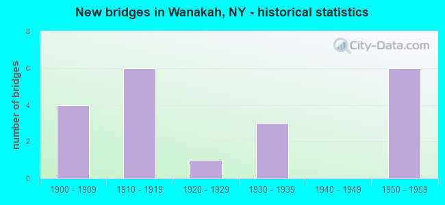
- New bridges - historical statistics
- 41900-1909
- 61910-1919
- 11920-1929
- 31930-1939
- 61950-1959


- Bridge Condition - Deck
- 20.0%Very good
- 20.0%Satisfactory
- 60.0%Poor

- Bridge Condition - Superstructure
- 20.0%Very good
- 60.0%Satisfactory
- 20.0%Fair

- Bridge Condition - Substructure
- 20.0%Satisfactory
- 80.0%Fair

- Bridge Condition - Channel
- 50.0%Good
- 50.0%Satisfactory
Find on map >> Show street view
Structure Number: 101545, Location: 5.6 MI SW JCT RTS 20 + 75 (Lat: 42.696094, Lng: -78.935994), Route carried "on" structure: US 20, Year Built: 1929, Year Reconstructed: 2000, Status: Open, Structure Length: 12.68m (41.60ft), Average Daily Traffic: 9,449 (year 2018), Truck Traffic: 6%, Average Future Daily Traffic: 9,493 (year 2040), Design Load: HS 20, Features Intersected: EIGHTEENMILE CRK
Minimum Vertical Clearance: 30+ m (98+ ft), Kilometerpoint: 19.968, Lanes on structure: 2, Base Highway Network: Yes, Owner: State Highway Agency, Approaching Roadway Width: 17.1m (56.1ft), Skew: 20 degrees, Material/Design: Concrete continuous, Design/Construction: Arch - Deck, Number Of Spans In Main Unit: 5, Length of Maximum Span: 44.8m (147.0ft), Curb-To-Curb Width: 17.1m (56.1ft), Out-to-Out Width: 18.1m (59.4ft)
Condition: Deck: Very good, Superstructure: Very good, Substructure: Satisfactory, Channel: Good, Operating Rating: 79.9 metric tons, Method Used To Determine Operating Rating: Field evaluation and documented engineering judgment, Inventory Rating: 32.7 metric tons, Method Used To Determine Inventory Rating: Field evaluation and documented engineering judgment, Structural Evaluation: Equal to present minimum criteria, Deck Geometry: Superior to present desirable criteria, Waterway Adequacy: Equal to present minimum criteria, Approach Roadway Alignment: Equal to present desirable criteria, Length Of Structure Improvement: 12.67m (41.57ft), Designated Inspection Frequency: Every 24 months, Critical Feature Inspection Frequency: Every 24 months, Inspection Date: July 2020, Critical Feature Inspection Date: July 2020, Bridge Improvement Cost: $11,300,000, Roadway Improvement Cost: $6,618,000, Total Project Cost: $17,918,000 ( Estimate for 2021), Deck Structure Type: Concrete Cast-file-Place, Wearing Surface/Protective System: Wearing Surface: Monolithic Concrete, Deck Protection: Epoxy Coated Reinforcing
Find on map >> Show street view
Structure Number: 221321, Location: 1.3 MI. SW OF ATHOL SPRGS (Lat: 42.757150, Lng: -78.881917), Route carried "on" structure: Other road , Year Built: 1930, Status: Open, Structure Length: 0.82m (2.69ft), Average Daily Traffic: 940 (year 2020), Truck Traffic: 3%, Average Future Daily Traffic: 1,316 (year 2040), Features Intersected: BARRICKS CREEK, Facility Carried by Structure: MT VERNON BLVD.
Minimum Vertical Clearance: 30+ m (98+ ft), Kilometerpoint: 1.480, Lanes on structure: 2, Owner: Town or Township Highway Agency, Approaching Roadway Width: 7.3m (24.0ft), Material/Design: Steel, Design/Construction: Stringer/Multi-beam, Number Of Spans In Main Unit: 1, Length of Maximum Span: 7.6m (24.9ft), Curb-To-Curb Width: 10.0m (32.8ft), Out-to-Out Width: 10.7m (35.1ft)
Condition: Deck: Satisfactory, Superstructure: Satisfactory, Substructure: Fair, Channel: Satisfactory, Operating Rating: 72.4 metric tons, Method Used To Determine Operating Rating: Field evaluation and documented engineering judgment, Inventory Rating: 31.5 metric tons, Method Used To Determine Inventory Rating: Field evaluation and documented engineering judgment, Structural Evaluation: Somewhat better than minimum adequacy, Deck Geometry: Equal to present minimum criteria, Waterway Adequacy: Better than present minimum criteria, Approach Roadway Alignment: Equal to present desirable criteria, Length Of Structure Improvement: 0.82m (2.69ft), Designated Inspection Frequency: Every 24 months, Inspection Date: September 2020, Bridge Improvement Cost: $450,000, Roadway Improvement Cost: $263,000, Total Project Cost: $713,000 ( Estimate for 2021), Deck Structure Type: Concrete Cast-file-Place, Wearing Surface/Protective System: Wearing Surface: Bituminous
Find on map >> Show street view
Structure Number: 551242, Location: 3.0 MI.NE OF I-90 INT 57A (Lat: 42.696292, Lng: -78.926939), Route carried "on" structure: County highway , Year Built: 1956, Status: Open, Structure Length: 10.88m (35.70ft), Average Daily Traffic: 246 (year 2017), Truck Traffic: 5%, Average Future Daily Traffic: 344 (year 2037), Design Load: HS 20+Mod, Features Intersected: 90IX EB, RTE I90, Facility Carried by Structure: NORTH CREEK ROAD
Minimum Vertical Clearance: 30+ m (98+ ft), Kilometerpoint: 3.862, Lanes on structure: 2, Lanes under structure: 4, Owner: State Toll Authority, Approaching Roadway Width: 7.9m (25.9ft), Skew: 4 degrees, Material/Design: Steel, Design/Construction: Stringer/Multi-beam, Number Of Spans In Main Unit: 5, Length of Maximum Span: 25.6m (84.0ft), Curb or Sidewalk Widths: Left: 0.8m (2.6ft), Right: 0.8m (2.6ft), Curb-To-Curb Width: 7.9m (25.9ft), Out-to-Out Width: 10.1m (33.1ft)
Condition: Deck: Poor, Superstructure: Fair, Substructure: Fair, Operating Rating: 43.1 metric tons, Method Used To Determine Operating Rating: Load and Resistance Factor Rating (LRFR) rating reported by rating factor(RF) method using HL-93 loadings, Inventory Rating: 33.0 metric tons, Method Used To Determine Inventory Rating: Load and Resistance Factor Rating (LRFR) rating reported by rating factor(RF) method using HL-93 loadings, Structural Evaluation: Somewhat better than minimum adequacy, Deck Geometry: Somewhat better than minimum adequacy, Underclear: High priority of corrective action, Approach Roadway Alignment: Meets minimum limits, Length Of Structure Improvement: 10.88m (35.70ft), Designated Inspection Frequency: Every 24 months, Inspection Date: October 2021, Bridge Improvement Cost: $3,816,000, Roadway Improvement Cost: $2,235,000, Total Project Cost: $6,050,000 ( Estimate for 2021), Deck Structure Type: Concrete Cast-file-Place, Wearing Surface/Protective System: Wearing Surface: Monolithic Concrete
Find on map >> Show street view
Structure Number: 551243, Location: 4.1 MI.NE OF I-90 INT 57A (Lat: 42.707483, Lng: -78.913203), Route carried "on" structure: County highway , Year Built: 1956, Status: Open, Structure Length: 6.68m (21.92ft), Average Daily Traffic: 4,175 (year 2020), Truck Traffic: 6%, Average Future Daily Traffic: 5,165 (year 2040), Design Load: HS 20+Mod, Features Intersected: RTE I90, Facility Carried by Structure: LAKEVIEW RD
Minimum Vertical Clearance: 30+ m (98+ ft), Kilometerpoint: 4.055, Lanes on structure: 2, Lanes under structure: 2, Owner: State Toll Authority, Approaching Roadway Width: 10.7m (35.1ft), Skew: 4 degrees, Material/Design: Steel, Design/Construction: Stringer/Multi-beam, Number Of Spans In Main Unit: 3, Length of Maximum Span: 27.1m (88.9ft), Curb or Sidewalk Widths: Left: 0.8m (2.6ft), Right: 0.8m (2.6ft), Curb-To-Curb Width: 9.1m (29.9ft), Out-to-Out Width: 11.3m (37.1ft)
Condition: Deck: Poor, Superstructure: Satisfactory, Substructure: Fair, Operating Rating: 60.8 metric tons, Method Used To Determine Operating Rating: Load Factor (LF), Inventory Rating: 36.3 metric tons, Method Used To Determine Inventory Rating: Load Factor (LF), Structural Evaluation: Somewhat better than minimum adequacy, Deck Geometry: Meets minimum limits, Underclear: High priority of corrective action, Approach Roadway Alignment: Equal to present minimum criteria, Length Of Structure Improvement: 6.67m (21.88ft), Designated Inspection Frequency: Every 24 months, Inspection Date: August 2020, Bridge Improvement Cost: $2,752,000, Roadway Improvement Cost: $1,612,000, Total Project Cost: $4,364,000 ( Estimate for 2021), Deck Structure Type: Concrete Cast-file-Place, Wearing Surface/Protective System: Wearing Surface: Bituminous
Find on map >> Show street view
Structure Number: 551244, Location: 4.1 MI.NE OF I-90 INT 57A (Lat: 42.707500, Lng: -78.911839), Route carried "on" structure: County highway , Year Built: 1956, Status: Open, Structure Length: 6.68m (21.92ft), Average Daily Traffic: 4,175 (year 2020), Truck Traffic: 6%, Average Future Daily Traffic: 5,165 (year 2040), Design Load: HS 20+Mod, Features Intersected: RTE I90, Facility Carried by Structure: LAKEVIEW RD
Minimum Vertical Clearance: 30+ m (98+ ft), Kilometerpoint: 4.151, Lanes on structure: 2, Lanes under structure: 2, Owner: State Toll Authority, Approaching Roadway Width: 8.5m (27.9ft), Skew: 4 degrees, Material/Design: Steel, Design/Construction: Stringer/Multi-beam, Number Of Spans In Main Unit: 3, Length of Maximum Span: 27.1m (88.9ft), Curb or Sidewalk Widths: Left: 0.8m (2.6ft), Right: 0.8m (2.6ft), Curb-To-Curb Width: 9.1m (29.9ft), Out-to-Out Width: 11.3m (37.1ft)
Condition: Deck: Poor, Superstructure: Satisfactory, Substructure: Fair, Operating Rating: 50.5 metric tons, Method Used To Determine Operating Rating: Load and Resistance Factor Rating (LRFR) rating reported by rating factor(RF) method using HL-93 loadings, Inventory Rating: 39.2 metric tons, Method Used To Determine Inventory Rating: Load and Resistance Factor Rating (LRFR) rating reported by rating factor(RF) method using HL-93 loadings, Structural Evaluation: Somewhat better than minimum adequacy, Deck Geometry: Meets minimum limits, Underclear: High priority of corrective action, Approach Roadway Alignment: Equal to present minimum criteria, Length Of Structure Improvement: 6.67m (21.88ft), Designated Inspection Frequency: Every 24 months, Inspection Date: August 2020, Bridge Improvement Cost: $2,752,000, Roadway Improvement Cost: $1,612,000, Total Project Cost: $4,364,000 ( Estimate for 2021), Deck Structure Type: Concrete Cast-file-Place, Wearing Surface/Protective System: Wearing Surface: Bituminous
Find on map >> Show street view
Structure Number: 551242, Location: 3.0 MI.NE OF I-90 INT 57A (Lat: 42.696292, Lng: -78.926939), Route carried "under" structure: Interstate 90, Year Built: 1956, Structure Length: 0. m, Average Daily Traffic: 7,300 (year 1977), Features Intersected: 90IX EB, RTE I90, Facility Carried by Structure: NORTH CREEK ROAD
Minimum Vertical Clearance: 4.39m (14.40ft), Kilometerpoint: 710.872, Lanes on structure: 2, Lanes under structure: 2, Toll: On Interstate toll segment, Material/Design: Steel, Design/Construction: Stringer/Multi-beam, Length of Maximum Span: 25.6m (84.0ft)
Find on map >> Show street view
Structure Number: 551243, Location: 4.1 MI.NE OF I-90 INT 57A (Lat: 42.707483, Lng: -78.913203), Route carried "under" structure: Interstate 90, Year Built: 1956, Structure Length: 0. m, Average Daily Traffic: 17,919 (year 2013), Features Intersected: RTE I90, Facility Carried by Structure: LAKEVIEW RD
Minimum Vertical Clearance: 4.60m (15.09ft), Kilometerpoint: 709.183, Lanes on structure: 2, Lanes under structure: 2, Toll: On Interstate toll segment, Material/Design: Steel, Design/Construction: Stringer/Multi-beam, Length of Maximum Span: 27.1m (88.9ft)
Find on map >> Show street view
Structure Number: 551244, Location: 4.1 MI.NE OF I-90 INT 57A (Lat: 42.707500, Lng: -78.911839), Route carried "under" structure: Interstate 90, Year Built: 1956, Structure Length: 0. m, Average Daily Traffic: 17,983 (year 2013), Features Intersected: RTE I90, Facility Carried by Structure: LAKEVIEW RD
Minimum Vertical Clearance: 4.50m (14.76ft), Kilometerpoint: 709.167, Lanes on structure: 2, Lanes under structure: 2, Toll: On Interstate toll segment, Material/Design: Steel, Design/Construction: Stringer/Multi-beam, Length of Maximum Span: 27.1m (88.9ft)
Find on map >> Show street view
Structure Number: 702993, Location: 1.2 MI NW JCT RTS 75 + 20 (Lat: 42.764644, Lng: -78.864236), Route carried "under" structure: State highway 75, Year Built: 1931, Structure Length: 0. m, Average Daily Traffic: 19,828 (year 1998), Features Intersected: RTE 75, Facility Carried by Structure: NORFOLK SOUTHERN
Minimum Vertical Clearance: 4.34m (14.24ft), Kilometerpoint: 32.421, Lanes under structure: 4, Material/Design: Steel, Design/Construction: Stringer/Multi-beam, Length of Maximum Span: 19.2m (63.0ft)
Find on map >> Show street view
Structure Number: 702994, Location: 0.2 MI NW JCT RTS 75 + 20 (Lat: 42.765031, Lng: -78.864464), Route carried "under" structure: State highway 75, Year Built: 1931, Structure Length: 0. m, Average Daily Traffic: 19,828 (year 1998), Features Intersected: RTE 75, Facility Carried by Structure: CSX TRANSPRTATION
Minimum Vertical Clearance: 4.45m (14.60ft), Kilometerpoint: 32.470, Lanes under structure: 4, Material/Design: Steel, Design/Construction: Girder and Floorbeam System, Length of Maximum Span: 19.8m (65.0ft)
Find on map >> Show street view
Structure Number: 7327741, Location: .6 MILE SW OF LAKE VIEW (Lat: 42.705903, Lng: -78.946928), Route carried "under" structure: County highway , Year Built: 1911, Structure Length: 0. m, Average Daily Traffic: 473 (year 1978), Features Intersected: N CREEK RD- CR467, Facility Carried by Structure: CSX TRANS/ AMTRAK
Minimum Vertical Clearance: 3.71m (12.17ft), Kilometerpoint: 0.000, Lanes under structure: 2, Material/Design: Steel, Design/Construction: Girder and Floorbeam System, Length of Maximum Span: 8.2m (26.9ft)
Find on map >> Show street view
Structure Number: 7327742, Location: .6 MILE SW OF LAKE VIEW (Lat: 42.705889, Lng: -78.946892), Route carried "under" structure: County highway , Year Built: 1911, Structure Length: 0. m, Average Daily Traffic: 473 (year 1978), Features Intersected: N CREEK RD- CR467, Facility Carried by Structure: CSX TRANS/ AMTRAK
Minimum Vertical Clearance: 3.68m (12.07ft), Kilometerpoint: 0.000, Lanes under structure: 2, Material/Design: Steel, Design/Construction: Girder and Floorbeam System, Length of Maximum Span: 8.2m (26.9ft)
Find on map >> Show street view
Structure Number: 7327743, Location: 0.6 MI. SW OF LAKE VIEW (Lat: 42.705869, Lng: -78.946847), Route carried "under" structure: County highway , Year Built: 1911, Structure Length: 0. m, Average Daily Traffic: 473 (year 1978), Features Intersected: N CREEK RD -CR467, Facility Carried by Structure: CSX RR
Minimum Vertical Clearance: 3.66m (12.01ft), Kilometerpoint: 0.000, Lanes under structure: 2, Material/Design: Steel, Design/Construction: Girder and Floorbeam System, Length of Maximum Span: 8.2m (26.9ft)
Find on map >> Show street view
Structure Number: 7327744, Location: 0.6 MI. SW OF LAKE VIEW (Lat: 42.705850, Lng: -78.946817), Route carried "under" structure: County highway , Year Built: 1911, Structure Length: 0. m, Average Daily Traffic: 473 (year 1978), Features Intersected: N CREEK RD -CR467, Facility Carried by Structure: CSX SERVICE RD
Minimum Vertical Clearance: 3.58m (11.75ft), Kilometerpoint: 0.000, Lanes under structure: 2, Material/Design: Steel, Design/Construction: Stringer/Multi-beam, Length of Maximum Span: 8.2m (26.9ft)
Find on map >> Show street view
Structure Number: 7708671, Location: 0.4 MI. SE OF WANAKAH (Lat: 42.741100, Lng: -78.898772), Route carried "under" structure: County highway , Year Built: 1911, Structure Length: 0. m, Average Daily Traffic: 1,922 (year 1978), Features Intersected: AMSDELL ROAD, Facility Carried by Structure: NORFOLK WESTERN
Minimum Vertical Clearance: 3.73m (12.24ft), Kilometerpoint: 0.000, Lanes under structure: 2, Material/Design: Steel, Design/Construction: Girder and Floorbeam System, Length of Maximum Span: 12.4m (40.7ft)
Find on map >> Show street view
Structure Number: 7708672, Location: 0.4 MI. SE OF WANAKAH (Lat: 42.741078, Lng: -78.898747), Route carried "under" structure: County highway , Year Built: 1911, Structure Length: 0. m, Average Daily Traffic: 1,922 (year 1978), Features Intersected: AMSDELL ROAD, Facility Carried by Structure: NORFOLK WESTERN
Minimum Vertical Clearance: 3.75m (12.30ft), Kilometerpoint: 0.000, Lanes under structure: 2, Material/Design: Steel, Design/Construction: Girder and Floorbeam System, Length of Maximum Span: 12.4m (40.7ft)
Find on map >> Show street view
Structure Number: 7708701, Location: 0.4 MI SE OF WANAKAH (Lat: 42.741394, Lng: -78.899144), Route carried "under" structure: County highway , Year Built: 1908, Structure Length: 0. m, Average Daily Traffic: 1,922 (year 1978), Features Intersected: AMSDELL RD. CR122, Facility Carried by Structure: CSX TRANSPORT
Minimum Vertical Clearance: 3.81m (12.50ft), Kilometerpoint: 0.000, Lanes under structure: 2, Material/Design: Steel, Design/Construction: Stringer/Multi-beam, Length of Maximum Span: 10.3m (33.8ft)
Find on map >> Show street view
Structure Number: 7708702, Location: 0.4 MI SE OF WANAKAH (Lat: 42.741369, Lng: -78.899114), Route carried "under" structure: County highway , Year Built: 1908, Structure Length: 0. m, Average Daily Traffic: 1,922 (year 1978), Features Intersected: AMSDELL RD. CR122, Facility Carried by Structure: CSX TRANSPORT
Minimum Vertical Clearance: 4.06m (13.32ft), Kilometerpoint: 0.000, Lanes under structure: 2, Material/Design: Steel, Design/Construction: Stringer/Multi-beam, Length of Maximum Span: 10.3m (33.8ft)
Find on map >> Show street view
Structure Number: 7708703, Location: 0.4 MI SE OF WANAKAH (Lat: 42.741344, Lng: -78.899081), Route carried "under" structure: County highway , Year Built: 1908, Structure Length: 0. m, Average Daily Traffic: 1,922 (year 1978), Features Intersected: AMSDELL RD. CR122, Facility Carried by Structure: CSX TRANSPORT
Minimum Vertical Clearance: 3.98m (13.06ft), Kilometerpoint: 0.000, Lanes under structure: 2, Material/Design: Steel, Design/Construction: Stringer/Multi-beam, Length of Maximum Span: 10.3m (33.8ft)
Find on map >> Show street view
Structure Number: 7708704, Location: 0.4 MI SE OF WANAKAH (Lat: 42.741322, Lng: -78.899056), Route carried "under" structure: County highway , Year Built: 1908, Structure Length: 0. m, Average Daily Traffic: 1,922 (year 1978), Features Intersected: AMSDELL RD. CR122, Facility Carried by Structure: CSX TRANSPORT
Minimum Vertical Clearance: 3.93m (12.89ft), Kilometerpoint: 0.000, Lanes under structure: 2, Material/Design: Steel, Design/Construction: Stringer/Multi-beam, Length of Maximum Span: 10.3m (33.8ft)