Bridge Statistics for Wanaque, New Jersey (NJ)
Condition, Traffic, Stress, Structural Evaluation, Project Costs
- National Bridge Inventory (NBI) Statistics
- 14Number of bridges
- 253ft / 77.5mTotal length
- $2,277,000Total costs
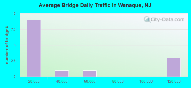
- 462,596Total average daily traffic
- 34,129Total average daily truck traffic
- National Bridge Inventory (NBI) Registered Bridges for Wanaque
- No street view available for this location
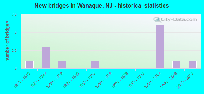
- New bridges - historical statistics
- 11910-1919
- 31920-1929
- 11930-1939
- 11950-1959
- 61990-1999
- 12000-2009
- 12010-2019
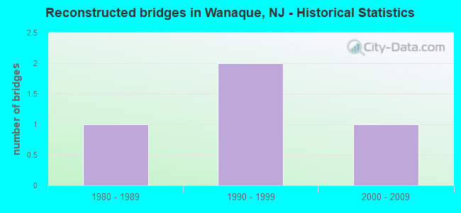
- Reconstructed bridges - Historical Statistics
- 11980-1989
- 21990-1999
- 12000-2009
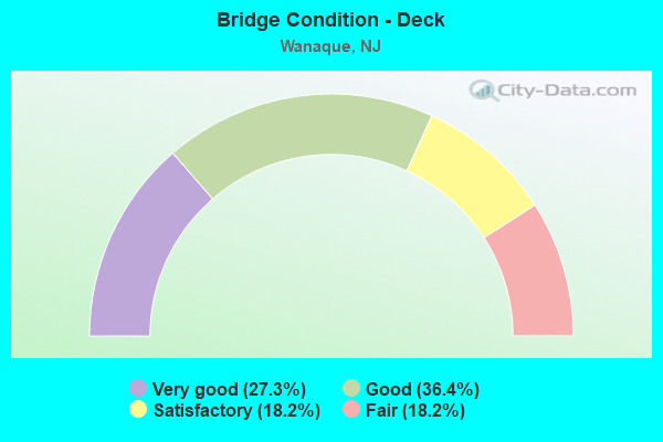
- Bridge Condition - Deck
- 27.3%Very good
- 36.4%Good
- 18.2%Satisfactory
- 18.2%Fair
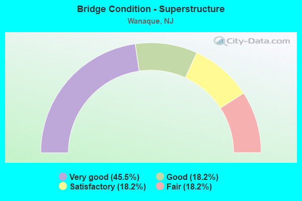
- Bridge Condition - Superstructure
- 45.5%Very good
- 18.2%Good
- 18.2%Satisfactory
- 18.2%Fair
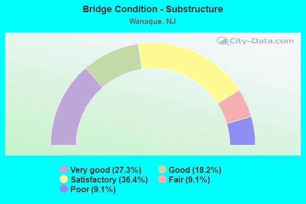
- Bridge Condition - Substructure
- 27.3%Very good
- 18.2%Good
- 36.4%Satisfactory
- 9.1%Fair
- 9.1%Poor
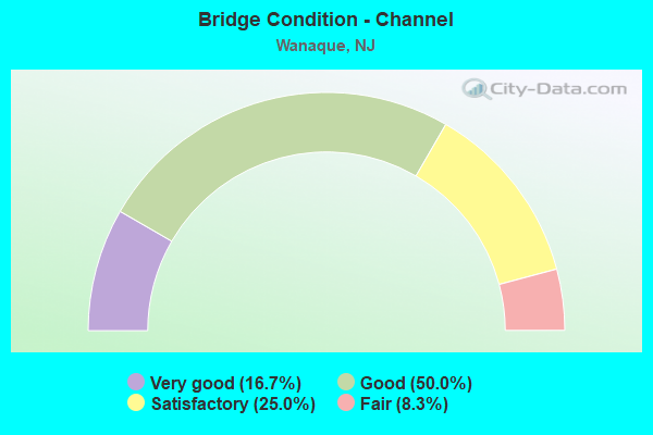
- Bridge Condition - Channel
- 16.7%Very good
- 50.0%Good
- 25.0%Satisfactory
- 8.3%Fair
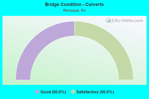
- Bridge Condition - Culverts
- 50.0%Good
- 50.0%Satisfactory
Find on map >> Show street view
Structure Number: 160004, Location: 3.5 MI N OF US202 & NJ23 (Lat: 40.992011, Lng: -74.280269), Route carried "on" structure: County highway 689, Year Built: 1929, Year Reconstructed: 1997, Status: Open, Structure Length: 4.02m (13.19ft), Average Daily Traffic: 46,760 (year 2021), Truck Traffic: 4%, Average Future Daily Traffic: 57,056 (year 2041), Design Load: HS 25 or greater, Features Intersected: RAMAPO RIVER
Minimum Vertical Clearance: 30+ m (98+ ft), Kilometerpoint: 4.538, Lanes on structure: 4, Base Highway Network: Yes, Owner: County Highway Agency, Approaching Roadway Width: 16.5m (54.1ft), Skew: 1 degrees, Material/Design: Steel continuous, Design/Construction: Stringer/Multi-beam, Number Of Spans In Main Unit: 3, Length of Maximum Span: 12.8m (42.0ft), Curb or Sidewalk Widths: Left: 1.8m (5.9ft), Right: 0.0m, Curb-To-Curb Width: 16.5m (54.1ft), Out-to-Out Width: 19.1m (62.7ft)
Condition: Deck: Good, Superstructure: Very good, Substructure: Satisfactory, Channel: Satisfactory, Operating Rating: 89.8 metric tons, Method Used To Determine Operating Rating: Load Factor (LF), Inventory Rating: 60.8 metric tons, Method Used To Determine Inventory Rating: Load Factor (LF), Structural Evaluation: Equal to present minimum criteria, Deck Geometry: Meets minimum limits, Waterway Adequacy: Superior to present desirable criteria, Approach Roadway Alignment: Equal to present desirable criteria, Length Of Structure Improvement: 4.02m (13.19ft), Designated Inspection Frequency: Every 24 months, Inspection Date: May 2021, Bridge Improvement Cost: $462,000, Roadway Improvement Cost: $46,000, Total Project Cost: $636,000 ( Estimate for 2015), Deck Structure Type: Concrete Cast-file-Place, Wearing Surface/Protective System: Wearing Surface: Monolithic Concrete, Deck Protection: Epoxy Coated Reinforcing
Find on map >> Show street view
Structure Number: 1600046, Location: 1.6 MI S OF BORO BNDRY (Lat: 41.043869, Lng: -74.292731), Route carried "on" structure: County highway 511, Year Built: 1924, Year Reconstructed: 1996, Status: Open, Structure Length: 3.20m (10.50ft), Average Daily Traffic: 18,700 (year 2021), Truck Traffic: 4%, Average Future Daily Traffic: 22,818 (year 2041), Design Load: HS 25 or greater, Features Intersected: WANAQUE RIVER
Minimum Vertical Clearance: 30+ m (98+ ft), Kilometerpoint: 36.983, Lanes on structure: 2, Base Highway Network: Yes, Owner: County Highway Agency, Approaching Roadway Width: 9.8m (32.2ft), Skew: 1 degrees, Material/Design: Steel, Design/Construction: Stringer/Multi-beam, Number Of Spans In Main Unit: 2, Length of Maximum Span: 16.2m (53.1ft), Curb or Sidewalk Widths: Left: 1.7m (5.6ft), Right: 1.7m (5.6ft), Curb-To-Curb Width: 9.8m (32.2ft), Out-to-Out Width: 13.7m (44.9ft)
Condition: Deck: Good, Superstructure: Satisfactory, Substructure: Satisfactory, Channel: Good, Operating Rating: 89.8 metric tons, Method Used To Determine Operating Rating: Load Factor (LF), Inventory Rating: 89.8 metric tons, Method Used To Determine Inventory Rating: Load Factor (LF), Structural Evaluation: Equal to present minimum criteria, Deck Geometry: Meets minimum limits, Waterway Adequacy: Superior to present desirable criteria, Approach Roadway Alignment: Equal to present minimum criteria, Length Of Structure Improvement: 3.20m (10.50ft), Designated Inspection Frequency: Every 24 months, Underwater Inspection Frequency: Every 48 months, Inspection Date: April 2021, Underwater Inspection Date: June 2021, Bridge Improvement Cost: $167,000, Total Project Cost: $167,000 ( Estimate for 2021), Deck Structure Type: Concrete Cast-file-Place, Wearing Surface/Protective System: Wearing Surface: Monolithic Concrete, Deck Protection: Epoxy Coated Reinforcing
Find on map >> Show street view
Structure Number: 160014, Location: EAST OF VALLEY RD(CR 681) (Lat: 40.958050, Lng: -74.224969), Route carried "on" structure: County highway 504, Year Built: 2015, Status: Open, Structure Length: 1.13m (3.71ft), Average Daily Traffic: 25,006 (year 2021), Truck Traffic: 4%, Average Future Daily Traffic: 30,512 (year 2041), Design Load: HS 20+Mod, Features Intersected: SINGAC BROOK
Minimum Vertical Clearance: 30+ m (98+ ft), Kilometerpoint: 16.303, Lanes on structure: 6, Base Highway Network: Yes, Owner: County Highway Agency, Approaching Roadway Width: 23.8m (78.1ft), Skew: 34 degrees, Material/Design: Steel, Design/Construction: Stringer/Multi-beam, Number Of Spans In Main Unit: 1, Length of Maximum Span: 8.8m (28.9ft), Curb or Sidewalk Widths: Left: 2.5m (8.2ft), Right: 2.1m (6.9ft), Curb-To-Curb Width: 23.8m (78.1ft), Out-to-Out Width: 30.0m (98.4ft)
Condition: Deck: Very good, Superstructure: Very good, Substructure: Very good, Channel: Very good, Operating Rating: 89.8 metric tons, Method Used To Determine Operating Rating: Load Factor (LF), Inventory Rating: 89.8 metric tons, Method Used To Determine Inventory Rating: Load Factor (LF), Structural Evaluation: Equal to present desirable criteria, Deck Geometry: Somewhat better than minimum adequacy, Waterway Adequacy: Equal to present desirable criteria, Approach Roadway Alignment: Equal to present desirable criteria, Designated Inspection Frequency: Every 24 months, Inspection Date: April 2021, Deck Structure Type: Concrete Cast-file-Place, Wearing Surface/Protective System: Wearing Surface: Monolithic Concrete, Deck Protection: Galvanized Reinforcing
Find on map >> Show street view
Structure Number: 1600146, Location: 0.1 MI W OF RINGWD AV/511 (Lat: 41.028961, Lng: -74.298869), Route carried "on" structure: City street , Year Built: 1920, Status: Open, Structure Length: 0.98m (3.22ft), Average Daily Traffic: 4,705 (year 2021), Truck Traffic: 1%, Average Future Daily Traffic: 6,340 (year 2041), Features Intersected: POST BROOK, Facility Carried by Structure: DOTY ROAD
Minimum Vertical Clearance: 30+ m (98+ ft), Kilometerpoint: 0.000, Lanes on structure: 2, Base Highway Network: Yes, Owner: County Highway Agency, Approaching Roadway Width: 6.1m (20.0ft), Skew: 1 degrees, Material/Design: Steel, Design/Construction: Stringer/Multi-beam, Number Of Spans In Main Unit: 1, Length of Maximum Span: 7.9m (25.9ft), Curb-To-Curb Width: 6.2m (20.3ft), Out-to-Out Width: 7.3m (24.0ft)
Condition: Deck: Satisfactory, Superstructure: Fair, Substructure: Fair, Channel: Good, Operating Rating: 34.5 metric tons, Method Used To Determine Operating Rating: Load Factor (LF), Inventory Rating: 20.9 metric tons, Method Used To Determine Inventory Rating: Load Factor (LF), Structural Evaluation: Somewhat better than minimum adequacy, Deck Geometry: High priority of replacement, Waterway Adequacy: Better than present minimum criteria, Approach Roadway Alignment: Equal to present desirable criteria, Length Of Structure Improvement: 0.98m (3.22ft), Designated Inspection Frequency: Every 24 months, Inspection Date: May 2021, Bridge Improvement Cost: $128,000, Roadway Improvement Cost: $50,000, Total Project Cost: $340,000 ( Estimate for 2021), Deck Structure Type: Concrete Cast-file-Place, Wearing Surface/Protective System: Wearing Surface: Bituminous
Find on map >> Show street view
Structure Number: 1600147, Location: 0.5 W OF RINGWOOD AV(511) (Lat: 41.030650, Lng: -74.308089), Route carried "on" structure: City street , Year Built: 1915, Year Reconstructed: 1986, Status: Open, Structure Length: 0.76m (2.49ft), Average Daily Traffic: 465 (year 2021), Truck Traffic: 1%, Average Future Daily Traffic: 630 (year 2041), Design Load: HS 20+Mod, Features Intersected: POST BROOK, Facility Carried by Structure: DOTY ROAD
Minimum Vertical Clearance: 30+ m (98+ ft), Kilometerpoint: 0.000, Lanes on structure: 2, Owner: County Highway Agency, Approaching Roadway Width: 7.6m (24.9ft), Material/Design: Prestressed concrete, Design/Construction: Slab, Number Of Spans In Main Unit: 1, Length of Maximum Span: 6.7m (22.0ft), Curb-To-Curb Width: 7.6m (24.9ft), Out-to-Out Width: 8.3m (27.2ft)
Condition: Deck: Fair, Superstructure: Fair, Substructure: Poor, Channel: Good, Operating Rating: 55.3 metric tons, Method Used To Determine Operating Rating: Load Factor (LF), Inventory Rating: 32.7 metric tons, Method Used To Determine Inventory Rating: Load Factor (LF), Structural Evaluation: Meets minimum limits, Deck Geometry: Meets minimum limits, Waterway Adequacy: Equal to present desirable criteria, Approach Roadway Alignment: Equal to present minimum criteria, Length Of Structure Improvement: 0.98m (3.22ft), Designated Inspection Frequency: Every 24 months, Inspection Date: May 2021, Bridge Improvement Cost: $544,000, Roadway Improvement Cost: $200,000, Total Project Cost: $1,120,000 ( Estimate for 2021), Deck Structure Type: Concrete Cast-file-Place, Wearing Surface/Protective System: Wearing Surface: Bituminous
Find on map >> Show street view
Structure Number: 160015, Location: 0.1 MI E.OF LAKESIDE ROAD (Lat: 41.152719, Lng: -74.349611), Route carried "on" structure: County highway 511, Year Built: 1993, Status: Open, Structure Length: 2.10m (6.89ft), Average Daily Traffic: 13,188 (year 2021), Truck Traffic: 4%, Average Future Daily Traffic: 16,092 (year 2041), Design Load: HS 25 or greater, Features Intersected: BELCHERS CREEK
Minimum Vertical Clearance: 30+ m (98+ ft), Kilometerpoint: 55.989, Lanes on structure: 2, Owner: County Highway Agency, Approaching Roadway Width: 10.4m (34.1ft), Skew: 1 degrees, Material/Design: Prestressed concrete, Design/Construction: Box Beam or Girders - Multiple, Number Of Spans In Main Unit: 1, Length of Maximum Span: 19.5m (64.0ft), Curb or Sidewalk Widths: Left: 1.8m (5.9ft), Right: 1.9m (6.2ft), Curb-To-Curb Width: 10.4m (34.1ft), Out-to-Out Width: 14.8m (48.6ft)
Condition: Deck: Fair, Superstructure: Good, Substructure: Good, Channel: Very good, Operating Rating: 61.7 metric tons, Method Used To Determine Operating Rating: Load Factor (LF), Inventory Rating: 36.3 metric tons, Method Used To Determine Inventory Rating: Load Factor (LF), Structural Evaluation: Better than present minimum criteria, Deck Geometry: Meets minimum limits, Waterway Adequacy: Equal to present desirable criteria, Approach Roadway Alignment: Equal to present desirable criteria, Designated Inspection Frequency: Every 24 months, Inspection Date: March 2021, Deck Structure Type: Concrete Cast-file-Place, Wearing Surface/Protective System: Wearing Surface: Monolithic Concrete, Deck Protection: Epoxy Coated Reinforcing
Find on map >> Show street view
Structure Number: 1600158, Location: 0.3 MI E OF CR511 JCT (Lat: 41.050350, Lng: -74.286450), Route carried "on" structure: City street , Year Built: 2009, Status: Open, Structure Length: 1.37m (4.49ft), Average Daily Traffic: 1,332 (year 2021), Truck Traffic: 1%, Average Future Daily Traffic: 1,626 (year 2041), Design Load: HS 25 or greater, Features Intersected: MEADOW BROOK, Facility Carried by Structure: BELMONT AVENUE
Minimum Vertical Clearance: 30+ m (98+ ft), Kilometerpoint: 0.000, Lanes on structure: 2, Owner: County Highway Agency, Approaching Roadway Width: 7.3m (24.0ft), Skew: 3 degrees, Material/Design: Steel, Design/Construction: Stringer/Multi-beam, Number Of Spans In Main Unit: 1, Length of Maximum Span: 12.2m (40.0ft), Curb or Sidewalk Widths: Left: 1.8m (5.9ft), Right: 1.8m (5.9ft), Curb-To-Curb Width: 7.3m (24.0ft), Out-to-Out Width: 11.9m (39.0ft)
Condition: Deck: Very good, Superstructure: Very good, Substructure: Very good, Channel: Good, Operating Rating: 89.8 metric tons, Method Used To Determine Operating Rating: Load Factor (LF), Inventory Rating: 89.8 metric tons, Method Used To Determine Inventory Rating: Load Factor (LF), Structural Evaluation: Equal to present desirable criteria, Deck Geometry: Meets minimum limits, Waterway Adequacy: Superior to present desirable criteria, Approach Roadway Alignment: Equal to present minimum criteria, Designated Inspection Frequency: Every 24 months, Inspection Date: March 2021, Deck Structure Type: Concrete Cast-file-Place, Wearing Surface/Protective System: Deck Protection: Epoxy Coated Reinforcing
Find on map >> Show street view
Structure Number: 1600363, Location: 0.3 MI E OF CR511 JCT (Lat: 41.052800, Lng: -74.284731), Route carried "on" structure: City street , Year Built: 1936, Year Reconstructed: 2009, Status: Open, Structure Length: 1.01m (3.31ft), Average Daily Traffic: 1,124 (year 2021), Truck Traffic: 1%, Average Future Daily Traffic: 1,372 (year 2041), Design Load: HS 25 or greater, Features Intersected: MEADOW BROOK, Facility Carried by Structure: PROSPECT STREET
Minimum Vertical Clearance: 30+ m (98+ ft), Kilometerpoint: 0.000, Lanes on structure: 2, Owner: County Highway Agency, Approaching Roadway Width: 6.7m (22.0ft), Material/Design: Steel, Design/Construction: Stringer/Multi-beam, Number Of Spans In Main Unit: 1, Length of Maximum Span: 9.1m (29.9ft), Curb or Sidewalk Widths: Left: 1.7m (5.6ft), Right: 1.7m (5.6ft), Curb-To-Curb Width: 6.8m (22.3ft), Out-to-Out Width: 11.0m (36.1ft)
Condition: Deck: Very good, Superstructure: Very good, Substructure: Very good, Channel: Satisfactory, Operating Rating: 89.8 metric tons, Method Used To Determine Operating Rating: Load Factor (LF), Inventory Rating: 89.8 metric tons, Method Used To Determine Inventory Rating: Load Factor (LF), Structural Evaluation: Equal to present desirable criteria, Deck Geometry: High priority of corrective action, Waterway Adequacy: Better than present minimum criteria, Approach Roadway Alignment: Equal to present desirable criteria, Designated Inspection Frequency: Every 24 months, Inspection Date: March 2021, Deck Structure Type: Concrete Cast-file-Place, Wearing Surface/Protective System: Deck Protection: Epoxy Coated Reinforcing
Find on map >> Show street view
Structure Number: 1613001, Location: 0.5 MILES E OF CO RT 511 (Lat: 41.056450, Lng: -74.281511), Route carried "on" structure: City street , Year Built: 1950, Status: Open, Structure Length: 0.70m (2.30ft), Average Daily Traffic: 407 (year 2021), Truck Traffic: 1%, Average Future Daily Traffic: 497 (year 2041), Design Load: HS 20, Features Intersected: HIGH MOUNTAIN BROOK, Facility Carried by Structure: MEADOWBROOK AVE
Minimum Vertical Clearance: 30+ m (98+ ft), Kilometerpoint: 0.000, Lanes on structure: 2, Owner: County Highway Agency, Approaching Roadway Width: 7.9m (25.9ft), Skew: 2 degrees, Material/Design: Concrete, Design/Construction: Culvert, Number Of Spans In Main Unit: 2, Length of Maximum Span: 3.0m (9.8ft), Curb or Sidewalk Widths: Left: 1.5m (4.9ft), Right: 1.5m (4.9ft), Curb-To-Curb Width: 9.1m (29.9ft), Out-to-Out Width: 15.2m (49.9ft)
Condition: Channel: Good, Culverts: Good, Operating Rating: 54.4 metric tons, Method Used To Determine Operating Rating: Field evaluation and documented engineering judgment, Inventory Rating: 32.7 metric tons, Method Used To Determine Inventory Rating: Field evaluation and documented engineering judgment, Structural Evaluation: Better than present minimum criteria, Deck Geometry: Equal to present minimum criteria, Waterway Adequacy: Equal to present desirable criteria, Approach Roadway Alignment: Better than present minimum criteria, Designated Inspection Frequency: Every 24 months, Inspection Date: March 2021, Deck Structure Type: Concrete Cast-file-Place, Wearing Surface/Protective System: Wearing Surface: Bituminous
Find on map >> Show street view
Structure Number: 1615151, Location: 0.04 MI SOUTH OF CR 511 (Lat: 41.016461, Lng: -74.297711), Route carried "on" structure: Interstate 287, Year Built: 1993, Status: Open, Structure Length: 1.10m (3.61ft), Average Daily Traffic: 105,791 (year 2021), Truck Traffic: 9%, Average Future Daily Traffic: 126,950 (year 2041), Design Load: HS 20, Features Intersected: MAIN BRNCH OF POST BROOK
Minimum Vertical Clearance: 30+ m (98+ ft), Kilometerpoint: 88.948, Lanes on structure: 8, Base Highway Network: Yes, Owner: State Highway Agency, Approaching Roadway Width: 41.1m (134.8ft), Skew: 33 degrees, Material/Design: Concrete, Design/Construction: Culvert, Number Of Spans In Main Unit: 3, Length of Maximum Span: 3.0m (9.8ft)
Condition: Channel: Good, Culverts: Satisfactory, Operating Rating: 54.4 metric tons, Method Used To Determine Operating Rating: Field evaluation and documented engineering judgment, Inventory Rating: 32.7 metric tons, Method Used To Determine Inventory Rating: Field evaluation and documented engineering judgment, Structural Evaluation: Equal to present minimum criteria, Waterway Adequacy: Equal to present desirable criteria, Approach Roadway Alignment: Equal to present desirable criteria, Designated Inspection Frequency: Every 24 months, Underwater Inspection Frequency: Every 48 months, Inspection Date: April 2021, Underwater Inspection Date: May 2021
Find on map >> Show street view
Structure Number: 1615155, Location: 2.17 MI. NORTH OF NJ 23 (Lat: 41.016881, Lng: -74.297150), Route carried "on" structure: Interstate 287, Year Built: 1993, Status: Open, Structure Length: 4.02m (13.19ft), Average Daily Traffic: 105,791 (year 2021), Truck Traffic: 9%, Average Future Daily Traffic: 126,950 (year 2041), Design Load: HS 20, Features Intersected: RINGWOOD AVENUE (CR511A)
Minimum Vertical Clearance: 30+ m (98+ ft), Kilometerpoint: 89.013, Lanes on structure: 8, Lanes under structure: 5, Base Highway Network: Yes, Owner: State Highway Agency, Approaching Roadway Width: 35.4m (116.1ft), Skew: 34 degrees, Material/Design: Steel, Design/Construction: Stringer/Multi-beam, Number Of Spans In Main Unit: 1, Length of Maximum Span: 37.5m (123.0ft), Curb-To-Curb Width: 41.3m (135.5ft), Out-to-Out Width: 43.1m (141.4ft)
Condition: Deck: Good, Superstructure: Good, Substructure: Satisfactory, Operating Rating: 86.2 metric tons, Method Used To Determine Operating Rating: Load Factor (LF), Inventory Rating: 51.7 metric tons, Method Used To Determine Inventory Rating: Load Factor (LF), Structural Evaluation: Equal to present minimum criteria, Deck Geometry: Superior to present desirable criteria, Underclear: High priority of corrective action, Approach Roadway Alignment: Equal to present desirable criteria, Length Of Structure Improvement: 4.31m (14.14ft), Designated Inspection Frequency: Every 24 months, Inspection Date: April 2021, Roadway Improvement Cost: $12,000, Total Project Cost: $14,000 ( Estimate for 2021), Deck Structure Type: Concrete Cast-file-Place, Wearing Surface/Protective System: Wearing Surface: Latex Concrete, Deck Protection: Epoxy Coated Reinforcing
Find on map >> Show street view
Structure Number: 1615156, Location: 0.9 miles N of I287&CR511 (Lat: 41.025089, Lng: -74.289019), Route carried "on" structure: Interstate 287, Year Built: 1993, Status: Open, Structure Length: 55.57m (182.32ft), Average Daily Traffic: 105,822 (year 2021), Truck Traffic: 9%, Average Future Daily Traffic: 129,122 (year 2041), Design Load: HS 20+Mod, Features Intersected: Wanaque River(Lake Inez)
Minimum Vertical Clearance: 30+ m (98+ ft), Kilometerpoint: 90.461, Lanes on structure: 6, Base Highway Network: Yes, Owner: State Highway Agency, Approaching Roadway Width: 35.4m (116.1ft), Skew: 31 degrees, Material/Design: Prestressed concrete continuous, Design/Construction: Stringer/Multi-beam, Number Of Spans In Main Unit: 14, Length of Maximum Span: 39.6m (129.9ft), Curb-To-Curb Width: 35.1m (115.2ft), Out-to-Out Width: 37.0m (121.4ft)
Condition: Deck: Good, Superstructure: Satisfactory, Substructure: Good, Channel: Satisfactory, Inventory Rating: 45.4 metric tons, Method Used To Determine Inventory Rating: Load Factor (LF), Structural Evaluation: Equal to present minimum criteria, Deck Geometry: Superior to present desirable criteria, Waterway Adequacy: Superior to present desirable criteria, Approach Roadway Alignment: Equal to present desirable criteria, Designated Inspection Frequency: Every 24 months, Inspection Date: May 2021, Deck Structure Type: Concrete Cast-file-Place, Wearing Surface/Protective System: Wearing Surface: Latex Concrete, Deck Protection: Epoxy Coated Reinforcing
Find on map >> Show street view
Structure Number: 1615157, Location: 0.05 MI S of RINGWOOD AVE (Lat: 41.017581, Lng: -74.297581), Route carried "on" structure: County highway 511, Year Built: 1995, Status: Open, Structure Length: 1.49m (4.89ft), Average Daily Traffic: 18,703 (year 2021), Truck Traffic: 4%, Average Future Daily Traffic: 22,821 (year 2041), Design Load: HS 25 or greater, Features Intersected: POST BROOK
Minimum Vertical Clearance: 30+ m (98+ ft), Kilometerpoint: 33.941, Lanes on structure: 3, Owner: State Highway Agency, Approaching Roadway Width: 16.5m (54.1ft), Material/Design: Prestressed concrete, Design/Construction: Slab, Number Of Spans In Main Unit: 1, Length of Maximum Span: 14.0m (45.9ft), Curb or Sidewalk Widths: Left: 1.8m (5.9ft), Right: 0.0m, Curb-To-Curb Width: 16.5m (54.1ft), Out-to-Out Width: 19.1m (62.7ft)
Condition: Deck: Satisfactory, Superstructure: Very good, Substructure: Satisfactory, Channel: Fair, Operating Rating: 78.9 metric tons, Method Used To Determine Operating Rating: Load Factor (LF), Inventory Rating: 47.2 metric tons, Method Used To Determine Inventory Rating: Load Factor (LF), Structural Evaluation: Equal to present minimum criteria, Deck Geometry: Better than present minimum criteria, Waterway Adequacy: Equal to present desirable criteria, Approach Roadway Alignment: Equal to present desirable criteria, Designated Inspection Frequency: Every 24 months, Inspection Date: April 2021, Deck Structure Type: Concrete Cast-file-Place, Wearing Surface/Protective System: Wearing Surface: Monolithic Concrete, Deck Protection: Epoxy Coated Reinforcing
Find on map >> Show street view
Structure Number: 1615155, Location: 2.17 MI. NORTH OF NJ 23 (Lat: 41.016881, Lng: -74.297150), Route carried "under" structure: Alternate County highway 511, Year Built: 1993, Structure Length: 0. m, Average Daily Traffic: 14,802 (year 2021), Truck Traffic: 4%, Features Intersected: RINGWOOD AVENUE (CR511A), Facility Carried by Structure: I-287
Minimum Vertical Clearance: 4.82m (15.81ft), Kilometerpoint: 15.675, Lanes on structure: 8, Lanes under structure: 5, Material/Design: Steel, Design/Construction: Stringer/Multi-beam, Length of Maximum Span: 37.5m (123.0ft)