Bridge Statistics for Wantagh, New York (NY)
Condition, Traffic, Stress, Structural Evaluation, Project Costs
- National Bridge Inventory (NBI) Statistics
- 22Number of bridges
- 180ft / 55.3mTotal length
- $164,723,000Total costs
- 361,027Total average daily traffic
- 8,513Total average daily truck traffic
- National Bridge Inventory (NBI) Registered Bridges for Wantagh
- No street view available for this location
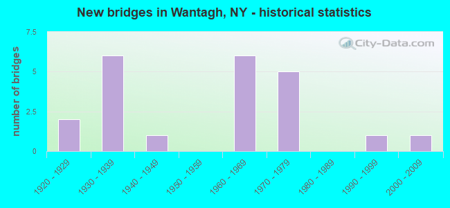
- New bridges - historical statistics
- 21920-1929
- 61930-1939
- 11940-1949
- 61960-1969
- 51970-1979
- 11990-1999
- 12000-2009
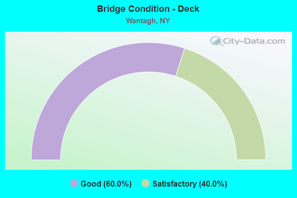
- Bridge Condition - Deck
- 60.0%Good
- 40.0%Satisfactory
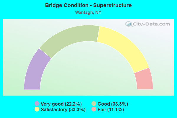
- Bridge Condition - Superstructure
- 22.2%Very good
- 33.3%Good
- 33.3%Satisfactory
- 11.1%Fair
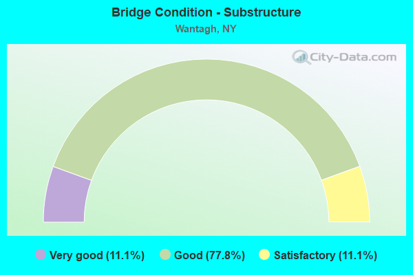
- Bridge Condition - Substructure
- 11.1%Very good
- 77.8%Good
- 11.1%Satisfactory
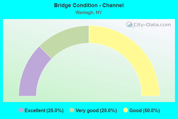
- Bridge Condition - Channel
- 25.0%Excellent
- 25.0%Very good
- 50.0%Good
Find on map >> Show street view
Structure Number: 1053249, Location: .7 MI S JCT RTS 105+135 (Lat: 40.680472, Lng: -73.495228), Route carried "on" structure: State highway 135, Year Built: 1970, Status: Open, Structure Length: 1.92m (6.30ft), Average Daily Traffic: 47,069 (year 2019), Truck Traffic: 6%, Average Future Daily Traffic: 55,988 (year 2040), Design Load: HS 20, Features Intersected: DEMOTT AVE
Minimum Vertical Clearance: 30+ m (98+ ft), Kilometerpoint: 1.722, Lanes on structure: 6, Lanes under structure: 2, Base Highway Network: Yes, Owner: State Highway Agency, Approaching Roadway Width: 29.6m (97.1ft), Skew: 20 degrees, Material/Design: Steel, Design/Construction: Stringer/Multi-beam, Number Of Spans In Main Unit: 1, Length of Maximum Span: 17.6m (57.7ft), Curb or Sidewalk Widths: Left: 0.5m (1.6ft), Right: 0.5m (1.6ft), Curb-To-Curb Width: 29.6m (97.1ft), Out-to-Out Width: 32.1m (105.3ft)
Condition: Deck: Good, Superstructure: Good, Substructure: Good, Operating Rating: 60.9 metric tons, Method Used To Determine Operating Rating: Load and Resistance Factor Rating (LRFR) rating reported by rating factor(RF) method using HL-93 loadings, Inventory Rating: 47.0 metric tons, Method Used To Determine Inventory Rating: Load and Resistance Factor Rating (LRFR) rating reported by rating factor(RF) method using HL-93 loadings, Structural Evaluation: Better than present minimum criteria, Deck Geometry: Superior to present desirable criteria, Underclear: Somewhat better than minimum adequacy, Approach Roadway Alignment: Better than present minimum criteria, Length Of Structure Improvement: 1.92m (6.30ft), Designated Inspection Frequency: Every 24 months, Inspection Date: August 2020, Bridge Improvement Cost: $4,940,000, Roadway Improvement Cost: $2,893,000, Total Project Cost: $7,833,000 ( Estimate for 2021), Deck Structure Type: Concrete Cast-file-Place, Wearing Surface/Protective System: Wearing Surface: Bituminous, Membrane: Preformed Fabric
Find on map >> Show street view
Structure Number: 1058499, Location: Jones Beach (Lat: 40.614389, Lng: -73.500689), Route carried "on" structure: State highway 908, Year Built: 2008, Status: Open, Structure Length: 21.52m (70.60ft), Average Daily Traffic: 14,296 (year 2020), Truck Traffic: 1%, Average Future Daily Traffic: 17,005 (year 2040), Design Load: HS 25 or greater, Features Intersected: Sloop Channel
Minimum Vertical Clearance: 5.54m (18.18ft), Kilometerpoint: 2.204, Lanes on structure: 5, Base Highway Network: Yes, Owner: State Highway Agency, Approaching Roadway Width: 24.4m (80.1ft), Skew: 20 degrees, Navigation Control: Yes ( Vertical Clearance: 6.1m (20.0ft), Horizontal Clearance: 15.2m (49.9ft)), Material/Design: Steel, Design/Construction: Movable - Bascule, Number Of Spans In Main Unit: 1, Number Of Approach Spans: 10, Length of Maximum Span: 32.0m (105.0ft), Curb or Sidewalk Widths: Left: 0.9m (3.0ft), Right: 3.6m (11.8ft), Curb-To-Curb Width: 24.6m (80.7ft), Out-to-Out Width: 32.2m (105.6ft)
Condition: Deck: Good, Superstructure: Very good, Substructure: Very good, Channel: Excellent, Operating Rating: 78.0 metric tons, Method Used To Determine Operating Rating: Load Factor (LF), Inventory Rating: 42.6 metric tons, Method Used To Determine Inventory Rating: Load Factor (LF), Structural Evaluation: Equal to present desirable criteria, Deck Geometry: Better than present minimum criteria, Waterway Adequacy: Equal to present minimum criteria, Approach Roadway Alignment: Equal to present desirable criteria, Length Of Structure Improvement: 21.51m (70.57ft), Designated Inspection Frequency: Every 24 months, Critical Feature Inspection Frequency: Every 24 months, Underwater Inspection Frequency: Every 60 months, Inspection Date: October 2020, Critical Feature Inspection Date: October 2020, Underwater Inspection Date: April 2019, Bridge Improvement Cost: $65,558,000, Roadway Improvement Cost: $38,391,000, Total Project Cost: $103,948,000 ( Estimate for 2021), Deck Structure Type: Concrete Cast-file-Place, Wearing Surface/Protective System: Wearing Surface: Integral Concrete, Deck Protection: Epoxy Coated Reinforcing
Find on map >> Show street view
Structure Number: 1058509, Location: WSP NEAR EAST BAY-NASSAU (Lat: 40.622869, Lng: -73.501239), Route carried "on" structure: State highway 908T, Year Built: 1930, Year Reconstructed: 2011, Status: Open, Structure Length: 16.86m (55.31ft), Average Daily Traffic: 14,296 (year 2020), Truck Traffic: 1%, Average Future Daily Traffic: 17,005 (year 2040), Design Load: HS 20, Features Intersected: GOOSE CREEK
Minimum Vertical Clearance: 30+ m (98+ ft), Kilometerpoint: 3.331, Lanes on structure: 5, Base Highway Network: Yes, Owner: State Highway Agency, Approaching Roadway Width: 21.6m (70.9ft), Skew: 20 degrees, Navigation Control: Yes ( Vertical Clearance: 999.9m (3,280.5ft), Horizontal Clearance: 23.1m (75.8ft)), Material/Design: Prestressed concrete continuous, Design/Construction: Stringer/Multi-beam, Number Of Spans In Main Unit: 9, Length of Maximum Span: 18.6m (61.0ft), Curb or Sidewalk Widths: Left: 0.9m (3.0ft), Right: 2.1m (6.9ft), Curb-To-Curb Width: 21.0m (68.9ft), Out-to-Out Width: 25.7m (84.3ft)
Condition: Deck: Satisfactory, Superstructure: Satisfactory, Substructure: Good, Channel: Good, Operating Rating: 62.6 metric tons, Method Used To Determine Operating Rating: Load Factor (LF), Inventory Rating: 35.4 metric tons, Method Used To Determine Inventory Rating: Load Factor (LF), Structural Evaluation: Equal to present minimum criteria, Deck Geometry: Meets minimum limits, Waterway Adequacy: Equal to present minimum criteria, Approach Roadway Alignment: Equal to present desirable criteria, Length Of Structure Improvement: 16.85m (55.28ft), Designated Inspection Frequency: Every 24 months, Underwater Inspection Frequency: Every 60 months, Inspection Date: July 2021, Underwater Inspection Date: July 2020, Bridge Improvement Cost: $11,091,000, Roadway Improvement Cost: $6,495,000, Total Project Cost: $17,586,000 ( Estimate for 2021), Deck Structure Type: Concrete Precast Panels, Wearing Surface/Protective System: Wearing Surface: Integral Concrete
Find on map >> Show street view
Structure Number: 1058519, Location: 4.1 MI S JCT RTS SSP &WSP (Lat: 40.640094, Lng: -73.507211), Route carried "on" structure: State highway 908T, Year Built: 1996, Status: Open, Structure Length: 3.63m (11.91ft), Average Daily Traffic: 14,296 (year 2020), Truck Traffic: 1%, Average Future Daily Traffic: 17,005 (year 2040), Design Load: HS 25 or greater, Features Intersected: SEAMANS ISLAND CK
Minimum Vertical Clearance: 30+ m (98+ ft), Kilometerpoint: 5.294, Lanes on structure: 5, Base Highway Network: Yes, Owner: State Highway Agency, Approaching Roadway Width: 24.1m (79.1ft), Skew: 20 degrees, Navigation Control: Yes ( Vertical Clearance: 3.6m (11.8ft), Horizontal Clearance: 27.4m (89.9ft)), Material/Design: Prestressed concrete, Design/Construction: Box Beam or Girders - Multiple, Number Of Spans In Main Unit: 1, Length of Maximum Span: 35.1m (115.2ft), Curb or Sidewalk Widths: Left: 0.0m, Right: 2.4m (7.9ft), Curb-To-Curb Width: 23.9m (78.4ft), Out-to-Out Width: 27.9m (91.5ft)
Condition: Deck: Good, Superstructure: Good, Substructure: Good, Channel: Very good, Operating Rating: 89.8 metric tons, Method Used To Determine Operating Rating: Load Factor (LF), Inventory Rating: 40.8 metric tons, Method Used To Determine Inventory Rating: Load Factor (LF), Structural Evaluation: Better than present minimum criteria, Deck Geometry: Equal to present minimum criteria, Waterway Adequacy: Equal to present desirable criteria, Approach Roadway Alignment: Equal to present desirable criteria, Length Of Structure Improvement: 3.62m (11.88ft), Designated Inspection Frequency: Every 24 months, Inspection Date: March 2020, Bridge Improvement Cost: $4,054,000, Roadway Improvement Cost: $2,374,000, Total Project Cost: $6,428,000 ( Estimate for 2021), Deck Structure Type: Concrete Cast-file-Place, Wearing Surface/Protective System: Wearing Surface: Monolithic Concrete, Deck Protection: Epoxy Coated Reinforcing
Find on map >> Show street view
Structure Number: 1058529, Location: 2.4 MI S JCT RTS SSP+WSP (Lat: 40.664161, Lng: -73.512053), Route carried "on" structure: State highway 908T, Year Built: 1931, Status: Open, Structure Length: 3.14m (10.30ft), Average Daily Traffic: 18,453 (year 2020), Truck Traffic: 1%, Average Future Daily Traffic: 21,949 (year 2040), Design Load: H 20, Features Intersected: MERRICK ROAD
Minimum Vertical Clearance: 30+ m (98+ ft), Kilometerpoint: 8.077, Lanes on structure: 7, Lanes under structure: 4, Base Highway Network: Yes, Owner: State Highway Agency, Approaching Roadway Width: 26.2m (86.0ft), Skew: 23 degrees, Material/Design: Concrete, Design/Construction: Arch - Deck, Number Of Spans In Main Unit: 1, Length of Maximum Span: 31.0m (101.7ft), Curb-To-Curb Width: 26.2m (86.0ft), Out-to-Out Width: 30.8m (101.0ft)
Condition: Superstructure: Satisfactory, Substructure: Good, Operating Rating: 74.7 metric tons, Method Used To Determine Operating Rating: Field evaluation and documented engineering judgment, Inventory Rating: 27.0 metric tons, Method Used To Determine Inventory Rating: Field evaluation and documented engineering judgment, Structural Evaluation: Equal to present minimum criteria, Deck Geometry: High priority of replacement, Underclear: Meets minimum limits, Approach Roadway Alignment: Equal to present desirable criteria, Length Of Structure Improvement: 3.13m (10.27ft), Designated Inspection Frequency: Every 24 months, Inspection Date: May 2021, Bridge Improvement Cost: $6,508,000, Roadway Improvement Cost: $3,811,000, Total Project Cost: $10,320,000 ( Estimate for 2021), Wearing Surface/Protective System: Wearing Surface: Bituminous, Membrane: Preformed Fabric
Find on map >> Show street view
Structure Number: 105853, Location: 1.7 MI S JCT SSP & WSP (Lat: 40.674347, Lng: -73.513439), Route carried "on" structure: Other road , Year Built: 1931, Status: Open, Structure Length: 2.07m (6.79ft), Average Daily Traffic: 5,367 (year 2020), Truck Traffic: 1%, Average Future Daily Traffic: 6,640 (year 2040), Features Intersected: RTE 908T, Facility Carried by Structure: PARK AVENUE
Minimum Vertical Clearance: 30+ m (98+ ft), Kilometerpoint: 0.241, Lanes on structure: 2, Lanes under structure: 3, Owner: State Highway Agency, Approaching Roadway Width: 7.0m (23.0ft), Skew: 1 degrees, Material/Design: Concrete, Design/Construction: Arch - Deck, Number Of Spans In Main Unit: 1, Length of Maximum Span: 18.2m (59.7ft), Curb or Sidewalk Widths: Left: 1.5m (4.9ft), Right: 0.0m, Curb-To-Curb Width: 7.0m (23.0ft), Out-to-Out Width: 10.1m (33.1ft)
Condition: Superstructure: Good, Substructure: Good, Operating Rating: 56.7 metric tons, Method Used To Determine Operating Rating: Field evaluation and documented engineering judgment, Inventory Rating: 22.6 metric tons, Method Used To Determine Inventory Rating: Field evaluation and documented engineering judgment, Structural Evaluation: Somewhat better than minimum adequacy, Deck Geometry: High priority of replacement, Underclear: High priority of corrective action, Approach Roadway Alignment: Equal to present desirable criteria, Length Of Structure Improvement: 2.07m (6.79ft), Designated Inspection Frequency: Every 24 months, Inspection Date: Febuary 2021, Bridge Improvement Cost: $1,828,000, Roadway Improvement Cost: $1,070,000, Total Project Cost: $2,898,000 ( Estimate for 2021), Wearing Surface/Protective System: Wearing Surface: Bituminous, Membrane: Preformed Fabric
Find on map >> Show street view
Structure Number: 1060789, Location: 1.9 MI S JCT RTS SSP&WSP (Lat: 40.671289, Lng: -73.514336), Route carried "on" structure: State highway 27, Year Built: 1928, Status: Open, Structure Length: 3.26m (10.70ft), Average Daily Traffic: 41,004 (year 2020), Truck Traffic: 12%, Average Future Daily Traffic: 47,310 (year 2040), Features Intersected: 908T 908T03011057 NB, RT
Minimum Vertical Clearance: 30+ m (98+ ft), Kilometerpoint: 18.568, Lanes on structure: 6, Lanes under structure: 6, Base Highway Network: Yes, Owner: State Highway Agency, Approaching Roadway Width: 21.9m (71.9ft), Skew: 32 degrees, Material/Design: Concrete, Design/Construction: Arch - Deck, Number Of Spans In Main Unit: 1, Length of Maximum Span: 29.5m (96.8ft), Curb or Sidewalk Widths: Left: 2.3m (7.5ft), Right: 2.1m (6.9ft), Curb-To-Curb Width: 21.9m (71.9ft), Out-to-Out Width: 28.7m (94.2ft)
Condition: Superstructure: Fair, Substructure: Good, Operating Rating: 59.0 metric tons, Method Used To Determine Operating Rating: Load Factor (LF), Inventory Rating: 37.2 metric tons, Method Used To Determine Inventory Rating: Load Factor (LF), Structural Evaluation: Somewhat better than minimum adequacy, Deck Geometry: High priority of corrective action, Underclear: High priority of corrective action, Approach Roadway Alignment: Better than present minimum criteria, Length Of Structure Improvement: 3.26m (10.70ft), Designated Inspection Frequency: Every 24 months, Inspection Date: Febuary 2021, Bridge Improvement Cost: $7,469,000, Roadway Improvement Cost: $4,374,000, Total Project Cost: $11,842,000 ( Estimate for 2021), Wearing Surface/Protective System: Wearing Surface: Bituminous, Membrane: Preformed Fabric
Find on map >> Show street view
Structure Number: 152038, Location: 1.7 MI S JCT SSP & WSP (Lat: 40.674481, Lng: -73.513775), Route carried "on" structure: Other road , Year Built: 1965, Status: Open, Structure Length: 2.04m (6.69ft), Average Daily Traffic: 5,367 (year 2020), Truck Traffic: 1%, Average Future Daily Traffic: 6,640 (year 2040), Design Load: HS 20, Features Intersected: RTE 908T, Facility Carried by Structure: PARK AVENUE
Minimum Vertical Clearance: 30+ m (98+ ft), Kilometerpoint: 0.193, Lanes on structure: 2, Lanes under structure: 3, Owner: State Highway Agency, Approaching Roadway Width: 7.0m (23.0ft), Skew: 1 degrees, Material/Design: Concrete, Design/Construction: Arch - Deck, Number Of Spans In Main Unit: 1, Length of Maximum Span: 18.2m (59.7ft), Curb or Sidewalk Widths: Left: 1.5m (4.9ft), Right: 0.0m, Curb-To-Curb Width: 7.0m (23.0ft), Out-to-Out Width: 10.1m (33.1ft)
Condition: Superstructure: Very good, Substructure: Good, Operating Rating: 85.6 metric tons, Method Used To Determine Operating Rating: Field evaluation and documented engineering judgment, Inventory Rating: 32.7 metric tons, Method Used To Determine Inventory Rating: Field evaluation and documented engineering judgment, Structural Evaluation: Better than present minimum criteria, Deck Geometry: High priority of replacement, Underclear: High priority of corrective action, Approach Roadway Alignment: Equal to present desirable criteria, Length Of Structure Improvement: 2.04m (6.69ft), Designated Inspection Frequency: Every 24 months, Inspection Date: Febuary 2021, Bridge Improvement Cost: $1,729,000, Roadway Improvement Cost: $1,012,000, Total Project Cost: $2,741,000 ( Estimate for 2021), Wearing Surface/Protective System: Wearing Surface: Bituminous, Membrane: Preformed Fabric
Find on map >> Show street view
Structure Number: 22616, Location: AT WANTAGH (Lat: 40.674758, Lng: -73.514567), Route carried "on" structure: County highway , Year Built: 1940, Status: Open, Structure Length: 0.82m (2.69ft), Average Daily Traffic: 5,367 (year 2020), Truck Traffic: 1%, Average Future Daily Traffic: 6,640 (year 2040), Features Intersected: MILL POND, Facility Carried by Structure: PARK AVE
Minimum Vertical Clearance: 30+ m (98+ ft), Kilometerpoint: 0.129, Lanes on structure: 2, Owner: Town or Township Highway Agency, Approaching Roadway Width: 7.0m (23.0ft), Material/Design: Concrete, Design/Construction: Slab, Number Of Spans In Main Unit: 1, Length of Maximum Span: 7.9m (25.9ft), Curb or Sidewalk Widths: Left: 1.5m (4.9ft), Right: 0.3m (1.0ft), Curb-To-Curb Width: 7.0m (23.0ft), Out-to-Out Width: 9.8m (32.2ft)
Condition: Deck: Satisfactory, Superstructure: Satisfactory, Substructure: Satisfactory, Channel: Good, Operating Rating: 58.6 metric tons, Method Used To Determine Operating Rating: Load and Resistance Factor Rating (LRFR) rating reported by rating factor(RF) method using HL-93 loadings, Inventory Rating: 45.0 metric tons, Method Used To Determine Inventory Rating: Load and Resistance Factor Rating (LRFR) rating reported by rating factor(RF) method using HL-93 loadings, Structural Evaluation: Equal to present minimum criteria, Deck Geometry: High priority of replacement, Waterway Adequacy: Equal to present desirable criteria, Approach Roadway Alignment: Meets minimum limits, Length Of Structure Improvement: 0.82m (2.69ft), Designated Inspection Frequency: Every 24 months, Underwater Inspection Frequency: Every 60 months, Inspection Date: March 2020, Underwater Inspection Date: July 2021, Bridge Improvement Cost: $711,000, Roadway Improvement Cost: $416,000, Total Project Cost: $1,127,000 ( Estimate for 2021), Wearing Surface/Protective System: Wearing Surface: Bituminous
Find on map >> Show street view
Structure Number: 1053249, Location: .7 MI S JCT RTS 105+135 (Lat: 40.680472, Lng: -73.495228), Route carried "under" structure: Other road , Year Built: 1970, Structure Length: 0. m, Average Daily Traffic: 3,200 (year 2021), Features Intersected: DEMOTT AVE, Facility Carried by Structure: RTE 135
Minimum Vertical Clearance: 4.37m (14.34ft), Kilometerpoint: 0.000, Lanes on structure: 6, Lanes under structure: 2, Material/Design: Steel, Design/Construction: Stringer/Multi-beam, Length of Maximum Span: 17.6m (57.7ft)
Find on map >> Show street view
Structure Number: 1058529, Location: 2.4 MI S JCT RTS SSP+WSP (Lat: 40.664161, Lng: -73.512053), Route carried "under" structure: County highway , Year Built: 1931, Structure Length: 0. m, Average Daily Traffic: 17,500 (year 1976), Features Intersected: MERRICK ROAD, Facility Carried by Structure: RTE 908T
Minimum Vertical Clearance: 6.10m (20.01ft), Kilometerpoint: 0.000, Lanes on structure: 7, Lanes under structure: 4, Material/Design: Concrete, Design/Construction: Arch - Deck, Length of Maximum Span: 31.0m (101.7ft)
Find on map >> Show street view
Structure Number: 105853, Location: 1.7 MI S JCT SSP & WSP (Lat: 40.674347, Lng: -73.513439), Route carried "under" structure: State highway 908T, Year Built: 1931, Structure Length: 0. m, Average Daily Traffic: 18,593 (year 2002), Features Intersected: RTE 908T, Facility Carried by Structure: PARK AVENUE
Minimum Vertical Clearance: 4.17m (13.68ft), Kilometerpoint: 9.155, Lanes on structure: 2, Lanes under structure: 3, Material/Design: Concrete, Design/Construction: Arch - Deck, Length of Maximum Span: 18.2m (59.7ft)
Find on map >> Show street view
Structure Number: 105854, Location: .8 MI S JCT SSP & WSP (Lat: 40.688144, Lng: -73.514383), Route carried "under" structure: Other road 908T, Year Built: 1971, Structure Length: 0. m, Average Daily Traffic: 31,155 (year 2002), Features Intersected: 908T908T03011069, RTE 90, Facility Carried by Structure: PED BR SO OF SSP
Minimum Vertical Clearance: 5.49m (18.01ft), Kilometerpoint: 10.668, Lanes under structure: 3, Material/Design: Steel, Design/Construction: Box Beam or Girders - Single/Spread, Length of Maximum Span: 30.4m (99.7ft)
Find on map >> Show street view
Structure Number: 105854, Location: .8 MI S JCT SSP & WSP (Lat: 40.688144, Lng: -73.514383), Route carried "under" structure: Other road , Year Built: 1971, Structure Length: 0. m, Features Intersected: 908T908T03011069, RTE 90, Facility Carried by Structure: PED BR SO OF SSP
Minimum Vertical Clearance: 4.80m (15.75ft), Kilometerpoint: 10.668, Lanes under structure: 3, Material/Design: Steel, Design/Construction: Box Beam or Girders - Single/Spread, Length of Maximum Span: 30.4m (99.7ft)
Find on map >> Show street view
Structure Number: 1060789, Location: 1.9 MI S JCT RTS SSP&WSP (Lat: 40.671289, Lng: -73.514336), Route carried "under" structure: State highway 908T, Year Built: 1928, Structure Length: 0. m, Average Daily Traffic: 18,593 (year 2002), Features Intersected: 908T 908T03011057 NB, RT, Facility Carried by Structure: RTE 27
Minimum Vertical Clearance: 5.03m (16.50ft), Kilometerpoint: 8.850, Lanes on structure: 6, Lanes under structure: 3, Material/Design: Concrete, Design/Construction: Arch - Deck, Length of Maximum Span: 29.5m (96.8ft)
Find on map >> Show street view
Structure Number: 152038, Location: 1.7 MI S JCT SSP & WSP (Lat: 40.674481, Lng: -73.513775), Route carried "under" structure: State highway 908T, Year Built: 1965, Structure Length: 0. m, Average Daily Traffic: 18,593 (year 2002), Features Intersected: RTE 908T, Facility Carried by Structure: PARK AVENUE
Minimum Vertical Clearance: 4.32m (14.17ft), Kilometerpoint: 9.155, Lanes on structure: 2, Lanes under structure: 3, Material/Design: Concrete, Design/Construction: Arch - Deck, Length of Maximum Span: 18.2m (59.7ft)
Find on map >> Show street view
Structure Number: 705608, Location: 1.1 MI S JCT RTS 105+135 (Lat: 40.675244, Lng: -73.493778), Route carried "under" structure: State highway 135, Year Built: 1969, Structure Length: 0. m, Average Daily Traffic: 45,585 (year 2002), Features Intersected: RTE 135, SEAMANS NECK RD, Facility Carried by Structure: LONG ISLAND
Minimum Vertical Clearance: 4.34m (14.24ft), Kilometerpoint: 1.416, Lanes under structure: 10, Material/Design: Steel, Design/Construction: Girder and Floorbeam System, Length of Maximum Span: 26.2m (86.0ft)
Find on map >> Show street view
Structure Number: 705608, Location: 1.1 MI S JCT RTS 105+135 (Lat: 40.675244, Lng: -73.493778), Route carried "under" structure: Other road , Year Built: 1969, Structure Length: 0. m, Average Daily Traffic: 100 (year 2021), Features Intersected: RTE 135, SEAMANS NECK RD, Facility Carried by Structure: LONG ISLAND
Minimum Vertical Clearance: 4.45m (14.60ft), Kilometerpoint: 0.000, Lanes under structure: 10, Material/Design: Steel, Design/Construction: Girder and Floorbeam System, Length of Maximum Span: 26.2m (86.0ft)
Find on map >> Show street view
Structure Number: 705678, Location: 1.9 MI S JCT RTS SSP&WSP (Lat: 40.672167, Lng: -73.514058), Route carried "under" structure: Other road 908T, Year Built: 1930, Structure Length: 0. m, Average Daily Traffic: 18,593 (year 2002), Features Intersected: RTE 908T, Facility Carried by Structure: LONG ISLAND-MONTK
Minimum Vertical Clearance: 4.50m (14.76ft), Kilometerpoint: 9.026, Lanes under structure: 6, Material/Design: Steel, Design/Construction: Girder and Floorbeam System, Length of Maximum Span: 30.1m (98.8ft)
Find on map >> Show street view
Structure Number: 770043, Location: 0.1 MI NW JCT RTS 27& WSP (Lat: 40.671819, Lng: -73.515589), Route carried "under" structure: Ramp State highway 908T, Year Built: 1977, Structure Length: 0. m, Average Daily Traffic: 100 (year 2021), Features Intersected: RTE 908T, Facility Carried by Structure: LIRR (BELLMORE)
Minimum Vertical Clearance: 4.14m (13.58ft), Kilometerpoint: 0.000, Lanes under structure: 2, Material/Design: Steel, Design/Construction: Girder and Floorbeam System, Length of Maximum Span: 32.6m (107.0ft)
Find on map >> Show street view
Structure Number: 770993, Location: AT WANTAGH (Lat: 40.672828, Lng: -73.510236), Route carried "under" structure: County highway , Year Built: 1968, Structure Length: 0. m, Average Daily Traffic: 16,500 (year 1977), Features Intersected: WANTAGH AVE, Facility Carried by Structure: LIRR MONTAUK BR
Minimum Vertical Clearance: 4.31m (14.14ft), Kilometerpoint: 0.000, Lanes under structure: 8, Material/Design: Prestressed concrete, Design/Construction: Box Beam or Girders - Multiple, Length of Maximum Span: 26.2m (86.0ft)
Find on map >> Show street view
Structure Number: 770994, Location: 0.4 MI EAST OF WANTAGH (Lat: 40.673953, Lng: -73.502631), Route carried "under" structure: Other road , Year Built: 1968, Structure Length: 0. m, Average Daily Traffic: 7,000 (year 2021), Features Intersected: OAKLAND AVE, Facility Carried by Structure: LIRR MONTAUK BR
Minimum Vertical Clearance: 4.36m (14.30ft), Kilometerpoint: 0.000, Lanes under structure: 3, Material/Design: Steel, Design/Construction: Girder and Floorbeam System, Length of Maximum Span: 20.1m (65.9ft)