Bridge Statistics for Warrensburg, New York (NY)
Condition, Traffic, Stress, Structural Evaluation, Project Costs
- National Bridge Inventory (NBI) Statistics
- 11Number of bridges
- 131ft / 40.3mTotal length
- $27,648,000Total costs
- 48,389Total average daily traffic
- 4,611Total average daily truck traffic
- National Bridge Inventory (NBI) Registered Bridges for Warrensburg
- No street view available for this location
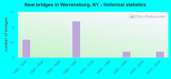
- New bridges - historical statistics
- 31930-1939
- 61960-1969
- 11990-1999
- 12010-2019

- Reconstructed bridges - Historical Statistics
- 31980-1989
- 01990-1999
- 22000-2009
- 12010-2019


- Bridge Condition - Deck
- 12.5%Very good
- 12.5%Good
- 37.5%Satisfactory
- 37.5%Fair

- Bridge Condition - Superstructure
- 12.5%Excellent
- 12.5%Good
- 37.5%Satisfactory
- 25.0%Fair
- 12.5%Poor

- Bridge Condition - Substructure
- 12.5%Excellent
- 25.0%Good
- 37.5%Satisfactory
- 25.0%Fair

- Bridge Condition - Channel
- 40.0%Very good
- 20.0%Good
- 20.0%Satisfactory
- 20.0%Fair
Find on map >> Show street view
Structure Number: 100575, Location: 0.6 MI SE JCT 9 & 418 (Lat: 43.488242, Lng: -73.760625), Route carried "on" structure: US 9, Year Built: 1931, Year Reconstructed: 1989, Status: Open, Structure Length: 2.99m (9.81ft), Average Daily Traffic: 11,036 (year 2019), Truck Traffic: 6%, Average Future Daily Traffic: 11,769 (year 2040), Design Load: H 20, Features Intersected: SCHROON RIVER
Minimum Vertical Clearance: 30+ m (98+ ft), Kilometerpoint: 23.958, Lanes on structure: 2, Base Highway Network: Yes, Owner: State Highway Agency, Approaching Roadway Width: 11.9m (39.0ft), Skew: 1 degrees, Material/Design: Steel, Design/Construction: Truss - Thru, Number Of Spans In Main Unit: 1, Length of Maximum Span: 28.9m (94.8ft), Curb or Sidewalk Widths: Left: 1.6m (5.2ft), Right: 1.6m (5.2ft), Curb-To-Curb Width: 9.1m (29.9ft), Out-to-Out Width: 9.8m (32.2ft)
Condition: Deck: Satisfactory, Superstructure: Poor, Substructure: Fair, Channel: Fair, Operating Rating: 24.6 metric tons, Method Used To Determine Operating Rating: Load and Resistance Factor Rating (LRFR) rating reported by rating factor(RF) method using HL-93 loadings, Inventory Rating: 19.1 metric tons, Method Used To Determine Inventory Rating: Load and Resistance Factor Rating (LRFR) rating reported by rating factor(RF) method using HL-93 loadings, Structural Evaluation: Meets minimum limits, Deck Geometry: High priority of corrective action, Waterway Adequacy: Somewhat better than minimum adequacy, Approach Roadway Alignment: Equal to present desirable criteria, Length Of Structure Improvement: 2.98m (9.78ft), Designated Inspection Frequency: Every 24 months, Critical Feature Inspection Frequency: Every 24 months, Underwater Inspection Frequency: Every 60 months, Inspection Date: May 2021, Critical Feature Inspection Date: May 2021, Underwater Inspection Date: September 2017, Bridge Improvement Cost: $3,668,000, Roadway Improvement Cost: $2,148,000, Total Project Cost: $5,816,000 ( Estimate for 2021), Deck Structure Type: Concrete Cast-file-Place, Wearing Surface/Protective System: Wearing Surface: Integral Concrete, Deck Protection: Epoxy Coated Reinforcing
Find on map >> Show street view
Structure Number: 103355, Location: JCT I87 & OLD ST RD 35 (Lat: 43.487094, Lng: -73.753533), Route carried "on" structure: County highway , Year Built: 1965, Year Reconstructed: 2019, Status: Open, Structure Length: 7.92m (25.98ft), Average Daily Traffic: 5,822 (year 2019), Truck Traffic: 8%, Average Future Daily Traffic: 8,151 (year 2039), Design Load: HS 20, Features Intersected: 87I 87I17101167 NB, RTE, Facility Carried by Structure: DIAMOND POINT RD
Minimum Vertical Clearance: 30+ m (98+ ft), Kilometerpoint: 0.241, Lanes on structure: 2, Lanes under structure: 6, Owner: State Highway Agency, Approaching Roadway Width: 11.3m (37.1ft), Skew: 2 degrees, Material/Design: Steel, Design/Construction: Stringer/Multi-beam, Number Of Spans In Main Unit: 4, Length of Maximum Span: 23.1m (75.8ft), Curb or Sidewalk Widths: Left: 0.5m (1.6ft), Right: 0.5m (1.6ft), Curb-To-Curb Width: 8.6m (28.2ft), Out-to-Out Width: 10.1m (33.1ft)
Condition: Deck: Good, Superstructure: Good, Substructure: Good, Operating Rating: 57.2 metric tons, Method Used To Determine Operating Rating: Load Factor (LF), Inventory Rating: 33.6 metric tons, Method Used To Determine Inventory Rating: Load Factor (LF), Structural Evaluation: Better than present minimum criteria, Deck Geometry: Meets minimum limits, Underclear: High priority of corrective action, Approach Roadway Alignment: Equal to present desirable criteria, Length Of Structure Improvement: 7.92m (25.98ft), Designated Inspection Frequency: Every 24 months, Inspection Date: July 2020, Bridge Improvement Cost: $1,665,000, Roadway Improvement Cost: $975,000, Total Project Cost: $2,640,000 ( Estimate for 2021), Deck Structure Type: Concrete Cast-file-Place, Wearing Surface/Protective System: Wearing Surface: Integral Concrete
Find on map >> Show street view
Structure Number: 1033561, Location: 3.4MI N OF JCT 87I < 9 (Lat: 43.500214, Lng: -73.747183), Route carried "on" structure: Interstate 87, Year Built: 1965, Year Reconstructed: 1991, Status: Open, Structure Length: 5.03m (16.50ft), Average Daily Traffic: 9,440 (year 2009), Truck Traffic: 20%, Design Load: HS 20, Features Intersected: EAST SCHROON RIVER RD
Minimum Vertical Clearance: 30+ m (98+ ft), Kilometerpoint: 28.351, Lanes on structure: 2, Lanes under structure: 2, Base Highway Network: Yes, Owner: State Highway Agency, Approaching Roadway Width: 8.5m (27.9ft), Skew: 3 degrees, Material/Design: Steel, Design/Construction: Stringer/Multi-beam, Number Of Spans In Main Unit: 3, Length of Maximum Span: 17.9m (58.7ft), Curb-To-Curb Width: 8.4m (27.6ft), Out-to-Out Width: 10.1m (33.1ft)
Condition: Deck: Fair, Superstructure: Satisfactory, Substructure: Satisfactory, Operating Rating: 62.6 metric tons, Method Used To Determine Operating Rating: Load Factor (LF), Inventory Rating: 36.3 metric tons, Method Used To Determine Inventory Rating: Load Factor (LF), Structural Evaluation: Equal to present minimum criteria, Deck Geometry: High priority of replacement, Underclear: Somewhat better than minimum adequacy, Approach Roadway Alignment: Equal to present desirable criteria, Length Of Structure Improvement: 5.02m (16.47ft), Designated Inspection Frequency: Every 24 months, Inspection Date: April 2021, Bridge Improvement Cost: $1,114,000, Roadway Improvement Cost: $652,000, Total Project Cost: $1,766,000 ( Estimate for 2021), Deck Structure Type: Concrete Cast-file-Place, Wearing Surface/Protective System: Wearing Surface: Integral Concrete
Find on map >> Show street view
Structure Number: 1033562, Location: 3.4MI N OF JCT 87I < 9 (Lat: 43.499750, Lng: -73.746794), Route carried "on" structure: Interstate 87, Year Built: 1965, Year Reconstructed: 1991, Status: Open, Structure Length: 4.69m (15.39ft), Average Daily Traffic: 6,103 (year 2009), Truck Traffic: 20%, Average Future Daily Traffic: 7,268 (year 2040), Design Load: HS 20, Features Intersected: EAST SCHROON RIVER RD
Minimum Vertical Clearance: 30+ m (98+ ft), Kilometerpoint: 28.351, Lanes on structure: 2, Lanes under structure: 2, Base Highway Network: Yes, Owner: State Highway Agency, Approaching Roadway Width: 8.5m (27.9ft), Skew: 3 degrees, Material/Design: Steel, Design/Construction: Stringer/Multi-beam, Number Of Spans In Main Unit: 3, Length of Maximum Span: 16.1m (52.8ft), Curb-To-Curb Width: 8.4m (27.6ft), Out-to-Out Width: 10.1m (33.1ft)
Condition: Deck: Fair, Superstructure: Satisfactory, Substructure: Satisfactory, Operating Rating: 63.5 metric tons, Method Used To Determine Operating Rating: Load Factor (LF), Inventory Rating: 38.1 metric tons, Method Used To Determine Inventory Rating: Load Factor (LF), Structural Evaluation: Equal to present minimum criteria, Deck Geometry: High priority of replacement, Underclear: High priority of corrective action, Approach Roadway Alignment: Equal to present desirable criteria, Length Of Structure Improvement: 4.69m (15.39ft), Designated Inspection Frequency: Every 24 months, Inspection Date: April 2021, Bridge Improvement Cost: $1,049,000, Roadway Improvement Cost: $614,000, Total Project Cost: $1,663,000 ( Estimate for 2021), Deck Structure Type: Concrete Cast-file-Place, Wearing Surface/Protective System: Wearing Surface: Integral Concrete
Find on map >> Show street view
Structure Number: 104824, Location: 0.2 MI SW JCT 9 & 418 (Lat: 43.491250, Lng: -73.770494), Route carried "on" structure: State highway 418, Year Built: 1933, Year Reconstructed: 2000, Status: Open, Structure Length: 5.03m (16.50ft), Average Daily Traffic: 2,554 (year 2018), Truck Traffic: 6%, Average Future Daily Traffic: 3,576 (year 2038), Design Load: HS 20, Features Intersected: SCHROON RIVER
Minimum Vertical Clearance: 4.45m (14.60ft), Kilometerpoint: 5.390, Lanes on structure: 2, Base Highway Network: Yes, Owner: State Highway Agency, Approaching Roadway Width: 7.3m (24.0ft), Material/Design: Steel, Design/Construction: Truss - Thru, Number Of Spans In Main Unit: 1, Length of Maximum Span: 48.7m (159.8ft), Curb or Sidewalk Widths: Left: 2.0m (6.6ft), Right: 0.0m, Curb-To-Curb Width: 7.3m (24.0ft), Out-to-Out Width: 8.0m (26.2ft)
Condition: Deck: Satisfactory, Superstructure: Fair, Substructure: Fair, Channel: Good, Operating Rating: 30.5 metric tons, Method Used To Determine Operating Rating: Load and Resistance Factor Rating (LRFR) rating reported by rating factor(RF) method using HL-93 loadings, Inventory Rating: 23.7 metric tons, Method Used To Determine Inventory Rating: Load and Resistance Factor Rating (LRFR) rating reported by rating factor(RF) method using HL-93 loadings, Structural Evaluation: Somewhat better than minimum adequacy, Deck Geometry: High priority of replacement, Waterway Adequacy: Somewhat better than minimum adequacy, Approach Roadway Alignment: High priority of corrective action, Length Of Structure Improvement: 5.02m (16.47ft), Designated Inspection Frequency: Every 24 months, Critical Feature Inspection Frequency: Every 24 months, Inspection Date: July 2020, Critical Feature Inspection Date: July 2020, Bridge Improvement Cost: $3,478,000, Roadway Improvement Cost: $2,037,000, Total Project Cost: $5,515,000 ( Estimate for 2021), Deck Structure Type: Other, Wearing Surface/Protective System: Wearing Surface: Bituminous
Find on map >> Show street view
Structure Number: 330513, Location: .5 M S INTERSTATE 87 EX24 (Lat: 43.511914, Lng: -73.747483), Route carried "on" structure: County highway , Year Built: 1930, Year Reconstructed: 2000, Status: Open, Structure Length: 6.43m (21.10ft), Average Daily Traffic: 673 (year 2017), Truck Traffic: 5%, Average Future Daily Traffic: 942 (year 2037), Design Load: HS 25 or greater, Features Intersected: SCHROON RIVER, Facility Carried by Structure: CO HOME BRIDGE RD
Minimum Vertical Clearance: 30+ m (98+ ft), Kilometerpoint: 0.161, Lanes on structure: 1, Owner: County Highway Agency, Approaching Roadway Width: 3.7m (12.1ft), Material/Design: Steel, Design/Construction: Truss - Thru, Number Of Spans In Main Unit: 2, Length of Maximum Span: 31.6m (103.7ft), Curb-To-Curb Width: 3.6m (11.8ft), Out-to-Out Width: 3.7m (12.1ft)
Condition: Deck: Satisfactory, Superstructure: Fair, Substructure: Good, Channel: Very good, Operating Rating: 57.2 metric tons, Method Used To Determine Operating Rating: Load Factor (LF), Inventory Rating: 42.6 metric tons, Method Used To Determine Inventory Rating: Load Factor (LF), Structural Evaluation: Somewhat better than minimum adequacy, Deck Geometry: High priority of replacement, Waterway Adequacy: Equal to present minimum criteria, Approach Roadway Alignment: Meets minimum limits, Length Of Structure Improvement: 6.43m (21.10ft), Designated Inspection Frequency: Every 24 months, Critical Feature Inspection Frequency: Every 24 months, Inspection Date: September 2020, Critical Feature Inspection Date: September 2020, Bridge Improvement Cost: $1,705,000, Roadway Improvement Cost: $998,000, Total Project Cost: $2,703,000 ( Estimate for 2021), Deck Structure Type: Concrete Cast-file-Place, Wearing Surface/Protective System: Wearing Surface: Monolithic Concrete, Deck Protection: Epoxy Coated Reinforcing
Find on map >> Show street view
Structure Number: 330572, Location: .5 MILE NW OF I87 EXIT 23 (Lat: 43.488914, Lng: -73.764608), Route carried "on" structure: County highway , Year Built: 1996, Status: Open, Structure Length: 3.44m (11.29ft), Average Daily Traffic: 1,637 (year 2020), Truck Traffic: 5%, Average Future Daily Traffic: 2,292 (year 2040), Design Load: HS 25 or greater, Features Intersected: SCHROON RIVER, Facility Carried by Structure: COUNTY ROAD 14
Minimum Vertical Clearance: 30+ m (98+ ft), Kilometerpoint: 0.032, Lanes on structure: 2, Owner: County Highway Agency, Approaching Roadway Width: 7.3m (24.0ft), Material/Design: Steel, Design/Construction: Truss - Thru, Number Of Spans In Main Unit: 1, Length of Maximum Span: 32.9m (107.9ft), Curb-To-Curb Width: 7.3m (24.0ft), Out-to-Out Width: 7.7m (25.3ft)
Condition: Deck: Fair, Superstructure: Satisfactory, Substructure: Satisfactory, Channel: Satisfactory, Operating Rating: 67.1 metric tons, Method Used To Determine Operating Rating: Load Factor (LF), Inventory Rating: 45.4 metric tons, Method Used To Determine Inventory Rating: Load Factor (LF), Structural Evaluation: Equal to present minimum criteria, Deck Geometry: Meets minimum limits, Waterway Adequacy: Somewhat better than minimum adequacy, Approach Roadway Alignment: Equal to present minimum criteria, Length Of Structure Improvement: 3.44m (11.29ft), Designated Inspection Frequency: Every 24 months, Critical Feature Inspection Frequency: Every 24 months, Inspection Date: May 2021, Critical Feature Inspection Date: May 2021, Bridge Improvement Cost: $1,728,000, Roadway Improvement Cost: $1,012,000, Total Project Cost: $2,740,000 ( Estimate for 2021), Deck Structure Type: Concrete Cast-file-Place, Wearing Surface/Protective System: Wearing Surface: Integral Concrete, Deck Protection: Epoxy Coated Reinforcing
Find on map >> Show street view
Structure Number: 330573, Location: 2 MI WEST OF I87 EXIT 23 (Lat: 43.487250, Lng: -73.779325), Route carried "on" structure: County highway , Year Built: 2011, Status: Open, Structure Length: 4.79m (15.72ft), Average Daily Traffic: 2,187 (year 2019), Truck Traffic: 5%, Average Future Daily Traffic: 3,062 (year 2039), Design Load: HS 25 or greater, Features Intersected: SCHROON RIVER, Facility Carried by Structure: MILTON STREET
Minimum Vertical Clearance: 5.21m (17.09ft), Kilometerpoint: 0.016, Lanes on structure: 2, Owner: County Highway Agency, Approaching Roadway Width: 8.2m (26.9ft), Material/Design: Steel, Design/Construction: Truss - Thru, Number Of Spans In Main Unit: 1, Length of Maximum Span: 47.2m (154.9ft), Curb or Sidewalk Widths: Left: 2.0m (6.6ft), Right: 0.0m, Curb-To-Curb Width: 7.8m (25.6ft), Out-to-Out Width: 9.1m (29.9ft)
Condition: Deck: Very good, Superstructure: Excellent, Substructure: Excellent, Channel: Very good, Operating Rating: 44.1 metric tons, Method Used To Determine Operating Rating: Load and Resistance Factor Rating (LRFR) rating reported by rating factor(RF) method using HL-93 loadings, Inventory Rating: 34.0 metric tons, Method Used To Determine Inventory Rating: Load and Resistance Factor Rating (LRFR) rating reported by rating factor(RF) method using HL-93 loadings, Structural Evaluation: Superior to present desirable criteria, Deck Geometry: High priority of replacement, Waterway Adequacy: Somewhat better than minimum adequacy, Approach Roadway Alignment: Equal to present desirable criteria, Length Of Structure Improvement: 4.78m (15.68ft), Designated Inspection Frequency: Every 24 months, Critical Feature Inspection Frequency: Every 24 months, Inspection Date: September 2021, Critical Feature Inspection Date: September 2021, Bridge Improvement Cost: $3,030,000, Roadway Improvement Cost: $1,775,000, Total Project Cost: $4,805,000 ( Estimate for 2021), Deck Structure Type: Concrete Cast-file-Place, Wearing Surface/Protective System: Wearing Surface: Integral Concrete, Deck Protection: Epoxy Coated Reinforcing
Find on map >> Show street view
Structure Number: 103355, Location: JCT I87 & OLD ST RD 35 (Lat: 43.487094, Lng: -73.753533), Route carried "under" structure: Interstate 87, Year Built: 1965, Structure Length: 0. m, Average Daily Traffic: 8,937 (year 1998), Features Intersected: 87I 87I17101167 NB, RTE, Facility Carried by Structure: DIAMOND POINT RD
Minimum Vertical Clearance: 5.15m (16.90ft), Kilometerpoint: 27.273, Lanes on structure: 2, Lanes under structure: 4, Material/Design: Steel, Design/Construction: Stringer/Multi-beam, Length of Maximum Span: 23.1m (75.8ft)
Find on map >> Show street view
Structure Number: 1033561, Location: 3.4MI N OF JCT 87I < 9 (Lat: 43.500214, Lng: -73.747183), Route carried "under" structure: Other road , Year Built: 1965, Structure Length: 0. m, Features Intersected: EAST SCHROON RIVER RD, Facility Carried by Structure: RTE I87
Minimum Vertical Clearance: 4.60m (15.09ft), Kilometerpoint: 0.000, Lanes on structure: 2, Lanes under structure: 2, Material/Design: Steel, Design/Construction: Stringer/Multi-beam, Length of Maximum Span: 17.9m (58.7ft)
Find on map >> Show street view
Structure Number: 1033562, Location: 3.4MI N OF JCT 87I < 9 (Lat: 43.499750, Lng: -73.746794), Route carried "under" structure: Other road , Year Built: 1965, Structure Length: 0. m, Features Intersected: EAST SCHROON RIVER RD, Facility Carried by Structure: RTE I87
Minimum Vertical Clearance: 4.32m (14.17ft), Kilometerpoint: 1.142, Lanes on structure: 2, Lanes under structure: 2, Material/Design: Steel, Design/Construction: Stringer/Multi-beam, Length of Maximum Span: 16.1m (52.8ft)