Bridge Statistics for Warrenville, Illinois (IL)
Condition, Traffic, Stress, Structural Evaluation, Project Costs
- National Bridge Inventory (NBI) Statistics
- 17Number of bridges
- 190ft / 57.6mTotal length
- 363,750Total average daily traffic
- 60,222Total average daily truck traffic
- National Bridge Inventory (NBI) Registered Bridges for Warrenville
- No street view available for this location
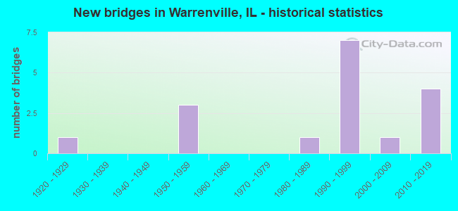
- New bridges - historical statistics
- 11920-1929
- 31950-1959
- 11980-1989
- 71990-1999
- 12000-2009
- 42010-2019
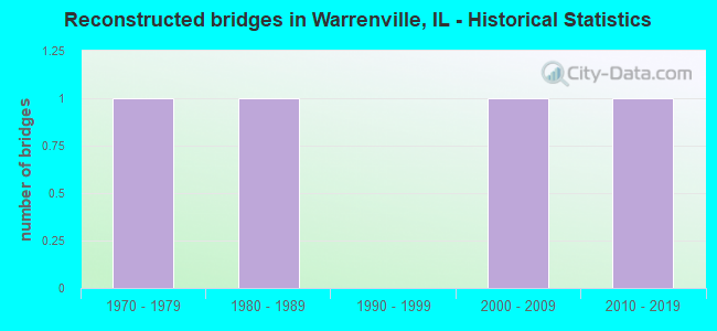
- Reconstructed bridges - Historical Statistics
- 11970-1979
- 11980-1989
- 01990-1999
- 12000-2009
- 12010-2019
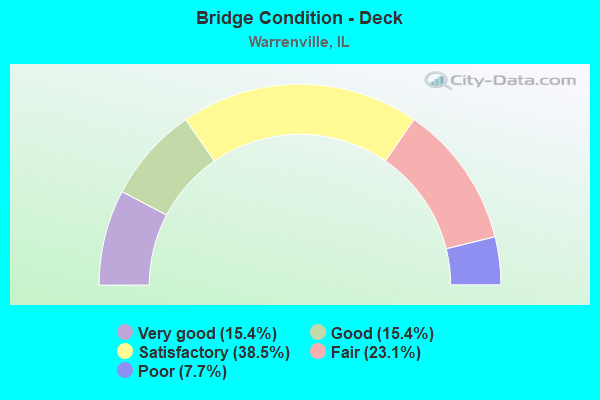
- Bridge Condition - Deck
- 15.4%Very good
- 15.4%Good
- 38.5%Satisfactory
- 23.1%Fair
- 7.7%Poor
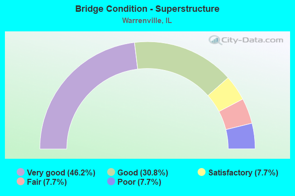
- Bridge Condition - Superstructure
- 46.2%Very good
- 30.8%Good
- 7.7%Satisfactory
- 7.7%Fair
- 7.7%Poor
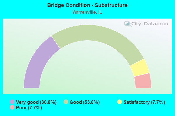
- Bridge Condition - Substructure
- 30.8%Very good
- 53.8%Good
- 7.7%Satisfactory
- 7.7%Poor
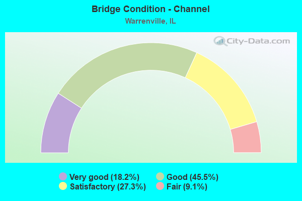
- Bridge Condition - Channel
- 18.2%Very good
- 45.5%Good
- 27.3%Satisfactory
- 9.1%Fair
Find on map >> Show street view
Structure Number: 220151, Location: 2.5 M E OF IL 59 (Lat: 41.830169, Lng: -88.160969), Route carried "on" structure: State highway 56, Year Built: 1985, Year Reconstructed: 2012, Status: Open, Structure Length: 0.94m (3.08ft), Average Daily Traffic: 18,600 (year 2021), Truck Traffic: 7%, Average Future Daily Traffic: 19,718 (year 2032), Design Load: HS 20, Features Intersected: PRVT RD & BIKE PATH
Minimum Vertical Clearance: 30+ m (98+ ft), Kilometerpoint: 27.262, Lanes on structure: 4, Base Highway Network: Yes, Owner: State Highway Agency, Approaching Roadway Width: 21.3m (69.9ft), Skew: 30 degrees, Material/Design: Concrete, Design/Construction: Slab, Number Of Spans In Main Unit: 1, Length of Maximum Span: 8.9m (29.2ft), Curb-To-Curb Width: 21.3m (69.9ft), Out-to-Out Width: 26.6m (87.3ft)
Condition: Deck: Satisfactory, Superstructure: Satisfactory, Substructure: Satisfactory, Operating Rating: 67.7 metric tons, Method Used To Determine Operating Rating: Load Factor (LF) rating reported by rating factor (RF) method using MS18 loading, Inventory Rating: 40.5 metric tons, Method Used To Determine Inventory Rating: Load Factor (LF) rating reported by rating factor (RF) method using MS18 loading, Structural Evaluation: Equal to present minimum criteria, Deck Geometry: Superior to present desirable criteria, Approach Roadway Alignment: Equal to present desirable criteria, Designated Inspection Frequency: Every 24 months, Inspection Date: November 2020, Deck Structure Type: Concrete Cast-file-Place, Wearing Surface/Protective System: Wearing Surface: Other, Deck Protection: Epoxy Coated Reinforcing
Find on map >> Show street view
Structure Number: 220165, Location: 0.25 M N OF IL 56 (Lat: 41.823889, Lng: -88.202828), Route carried "on" structure: State highway 59, Year Built: 1990, Status: Open, Structure Length: 0.78m (2.56ft), Average Daily Traffic: 35,300 (year 2021), Truck Traffic: 10%, Average Future Daily Traffic: 36,316 (year 2032), Features Intersected: FERRY CREEK
Minimum Vertical Clearance: 30+ m (98+ ft), Kilometerpoint: 35.372, Lanes on structure: 5, Base Highway Network: Yes, Owner: State Highway Agency, Approaching Roadway Width: 20.7m (67.9ft), Material/Design: Concrete, Design/Construction: Culvert, Number Of Spans In Main Unit: 2, Length of Maximum Span: 3.6m (11.8ft)
Condition: Channel: Fair, Culverts: Satisfactory, Operating Rating: 54.1 metric tons, Method Used To Determine Operating Rating: Load Factor (LF) rating reported by rating factor (RF) method using MS18 loading, Inventory Rating: 32.4 metric tons, Method Used To Determine Inventory Rating: Load Factor (LF) rating reported by rating factor (RF) method using MS18 loading, Structural Evaluation: Equal to present minimum criteria, Waterway Adequacy: Better than present minimum criteria, Approach Roadway Alignment: Equal to present desirable criteria, Designated Inspection Frequency: Every 24 months, Inspection Date: November 2020
Find on map >> Show street view
Structure Number: 220172, Location: .25MI N.OF DIEHL RD (Lat: 41.806336, Lng: -88.167939), Route carried "on" structure: Interstate 88, Year Built: 1992, Status: Open, Structure Length: 4.88m (16.01ft), Average Daily Traffic: 54,550 (year 2020), Truck Traffic: 22%, Average Future Daily Traffic: 70,461 (year 2032), Design Load: HS 20+Mod, Features Intersected: WINFIELD RD
Minimum Vertical Clearance: 30+ m (98+ ft), Kilometerpoint: 201.146, Lanes on structure: 2, Lanes under structure: 4, Base Highway Network: Yes, Toll: On toll road, Owner: State Toll Authority, Approaching Roadway Width: 17.7m (58.1ft), Material/Design: Prestressed concrete continuous, Design/Construction: Stringer/Multi-beam, Number Of Spans In Main Unit: 2, Length of Maximum Span: 24.4m (80.1ft), Curb-To-Curb Width: 17.7m (58.1ft), Out-to-Out Width: 18.9m (62.0ft)
Condition: Deck: Satisfactory, Superstructure: Good, Substructure: Good, Operating Rating: 61.2 metric tons, Method Used To Determine Operating Rating: Load Factor (LF) rating reported by rating factor (RF) method using MS18 loading, Inventory Rating: 36.6 metric tons, Method Used To Determine Inventory Rating: Load Factor (LF) rating reported by rating factor (RF) method using MS18 loading, Structural Evaluation: Better than present minimum criteria, Deck Geometry: Superior to present desirable criteria, Underclear: Equal to present minimum criteria, Approach Roadway Alignment: Equal to present desirable criteria, Designated Inspection Frequency: Every 24 months, Inspection Date: August 2019, Deck Structure Type: Concrete Cast-file-Place, Wearing Surface/Protective System: Wearing Surface: Bituminous
Find on map >> Show street view
Structure Number: 220173, Location: .25MI N.OF DIEHL RD (Lat: 41.806339, Lng: -88.167553), Route carried "on" structure: Interstate 88, Year Built: 1992, Status: Open, Structure Length: 4.88m (16.01ft), Average Daily Traffic: 54,550 (year 2020), Truck Traffic: 22%, Average Future Daily Traffic: 70,461 (year 2032), Design Load: HS 20+Mod, Features Intersected: WINFIELD ROAD
Minimum Vertical Clearance: 30+ m (98+ ft), Kilometerpoint: 201.163, Lanes on structure: 3, Lanes under structure: 4, Base Highway Network: Yes, Toll: On toll road, Owner: State Toll Authority, Approaching Roadway Width: 17.7m (58.1ft), Material/Design: Prestressed concrete continuous, Design/Construction: Stringer/Multi-beam, Number Of Spans In Main Unit: 2, Length of Maximum Span: 24.4m (80.1ft), Curb-To-Curb Width: 17.7m (58.1ft), Out-to-Out Width: 18.9m (62.0ft)
Condition: Deck: Satisfactory, Superstructure: Good, Substructure: Good, Operating Rating: 61.2 metric tons, Method Used To Determine Operating Rating: Load Factor (LF) rating reported by rating factor (RF) method using MS18 loading, Inventory Rating: 36.6 metric tons, Method Used To Determine Inventory Rating: Load Factor (LF) rating reported by rating factor (RF) method using MS18 loading, Structural Evaluation: Better than present minimum criteria, Deck Geometry: Better than present minimum criteria, Underclear: Equal to present minimum criteria, Approach Roadway Alignment: Equal to present desirable criteria, Designated Inspection Frequency: Every 24 months, Inspection Date: August 2019, Deck Structure Type: Concrete Cast-file-Place, Wearing Surface/Protective System: Wearing Surface: Bituminous
Find on map >> Show street view
Structure Number: 222027, Location: 1.3 M NE IL 59 (Lat: 41.825119, Lng: -88.179581), Route carried "on" structure: State highway 56, Year Built: 2012, Status: Open, Structure Length: 5.03m (16.50ft), Average Daily Traffic: 15,500 (year 2021), Truck Traffic: 4%, Average Future Daily Traffic: 16,153 (year 2032), Features Intersected: W BR DUPAGE RIVER
Minimum Vertical Clearance: 30+ m (98+ ft), Kilometerpoint: 25.540, Lanes on structure: 2, Base Highway Network: Yes, Owner: State Highway Agency, Approaching Roadway Width: 23.4m (76.8ft), Skew: 32 degrees, Material/Design: Prestressed concrete continuous, Design/Construction: Stringer/Multi-beam, Number Of Spans In Main Unit: 2, Length of Maximum Span: 24.7m (81.0ft), Curb or Sidewalk Widths: Left: 3.2m (10.5ft), Right: 0.0m, Curb-To-Curb Width: 23.4m (76.8ft), Out-to-Out Width: 35.2m (115.5ft)
Condition: Deck: Good, Superstructure: Very good, Substructure: Good, Channel: Very good, Operating Rating: 97.2 metric tons, Method Used To Determine Operating Rating: Load Factor (LF) rating reported by rating factor (RF) method using MS18 loading, Inventory Rating: 45.7 metric tons, Method Used To Determine Inventory Rating: Load Factor (LF) rating reported by rating factor (RF) method using MS18 loading, Structural Evaluation: Better than present minimum criteria, Deck Geometry: Superior to present desirable criteria, Waterway Adequacy: Equal to present desirable criteria, Approach Roadway Alignment: Equal to present desirable criteria, Designated Inspection Frequency: Every 48 months, Inspection Date: March 2019, Deck Structure Type: Concrete Cast-file-Place, Wearing Surface/Protective System: Deck Protection: Epoxy Coated Reinforcing
Find on map >> Show street view
Structure Number: 223002, Location: 0.7 MI N IL 56 (Lat: 41.841436, Lng: -88.170928), Route carried "on" structure: Other road , Year Built: 1929, Year Reconstructed: 1989, Status: Open, Structure Length: 0.94m (3.08ft), Average Daily Traffic: 16,900 (year 2020), Truck Traffic: 10%, Average Future Daily Traffic: 27,850 (year 2032), Design Load: HS 20, Features Intersected: SPRING BROOK, Facility Carried by Structure: WINFIELD RD
Minimum Vertical Clearance: 30+ m (98+ ft), Kilometerpoint: 5.472, Lanes on structure: 4, Base Highway Network: Yes, Owner: County Highway Agency, Approaching Roadway Width: 17.7m (58.1ft), Skew: 21 degrees, Material/Design: Concrete, Design/Construction: Slab, Number Of Spans In Main Unit: 1, Length of Maximum Span: 9.1m (29.9ft), Curb or Sidewalk Widths: Left: 1.5m (4.9ft), Right: 1.5m (4.9ft), Curb-To-Curb Width: 17.7m (58.1ft), Out-to-Out Width: 21.3m (69.9ft)
Condition: Deck: Fair, Superstructure: Fair, Substructure: Good, Channel: Satisfactory, Operating Rating: 50.9 metric tons, Method Used To Determine Operating Rating: Load Factor (LF) rating reported by rating factor (RF) method using MS18 loading, Inventory Rating: 30.5 metric tons, Method Used To Determine Inventory Rating: Load Factor (LF) rating reported by rating factor (RF) method using MS18 loading, Structural Evaluation: Somewhat better than minimum adequacy, Deck Geometry: Somewhat better than minimum adequacy, Waterway Adequacy: Equal to present desirable criteria, Approach Roadway Alignment: Equal to present minimum criteria, Designated Inspection Frequency: Every 24 months, Inspection Date: September 2020, Deck Structure Type: Concrete Cast-file-Place
Find on map >> Show street view
Structure Number: 223027, Location: 0.2 MI E IL 59 (Lat: 41.842428, Lng: -88.198672), Route carried "on" structure: Other road , Year Built: 1954, Year Reconstructed: 1979, Status: Posted for load, Structure Length: 3.61m (11.84ft), Average Daily Traffic: 2,200 (year 2020), Truck Traffic: 4%, Average Future Daily Traffic: 5,570 (year 2032), Design Load: HS 20, Features Intersected: W Br DuPage River, Facility Carried by Structure: FAU-3818 Mack Road
Minimum Vertical Clearance: 30+ m (98+ ft), Kilometerpoint: 0.322, Lanes on structure: 2, Owner: City or Municipal Highway Agency, Approaching Roadway Width: 9.1m (29.9ft), Material/Design: Prestressed concrete, Design/Construction: Box Beam or Girders - Multiple, Number Of Spans In Main Unit: 4, Length of Maximum Span: 8.6m (28.2ft), Curb-To-Curb Width: 10.4m (34.1ft), Out-to-Out Width: 11.0m (36.1ft)
Condition: Deck: Poor, Superstructure: Poor, Substructure: Poor, Channel: Satisfactory, Operating Rating: 7.5 metric tons, Method Used To Determine Operating Rating: Load Factor (LF) rating reported by rating factor (RF) method using MS18 loading, Inventory Rating: 4.5 metric tons, Method Used To Determine Inventory Rating: Load Factor (LF) rating reported by rating factor (RF) method using MS18 loading, Structural Evaluation: High priority of corrective action, Deck Geometry: Somewhat better than minimum adequacy, Waterway Adequacy: Equal to present desirable criteria, Approach Roadway Alignment: Superior to present desirable criteria, Bridge Posting: Required (Relationship of Operating Rating to Maximum Legal Load: > 39.9% below), Designated Inspection Frequency: Every 24 months, Other Special Inspection Frequency: Every 1 months, Inspection Date: June 2021, Other Special Inspection Date: Febuary 2022, Deck Structure Type: Concrete Precast Panels, Wearing Surface/Protective System: Wearing Surface: Bituminous, Membrane: Built-up
Find on map >> Show street view
Structure Number: 223045, Location: .2M W of Winfield Rd (Lat: 41.817592, Lng: -88.171858), Route carried "on" structure: Other road , Year Built: 2013, Year Reconstructed: 2015, Status: Open, Structure Length: 7.32m (24.02ft), Average Daily Traffic: 3,200 (year 2020), Truck Traffic: 7%, Average Future Daily Traffic: 20,000 (year 2040), Design Load: HS 25 or greater, Features Intersected: W Br of DuPage River, Facility Carried by Structure: Warrenville Road
Minimum Vertical Clearance: 30+ m (98+ ft), Kilometerpoint: 1.674, Lanes on structure: 2, Base Highway Network: Yes, Owner: County Highway Agency, Approaching Roadway Width: 12.2m (40.0ft), Material/Design: Prestressed concrete, Design/Construction: Slab, Number Of Spans In Main Unit: 4, Length of Maximum Span: 20.4m (66.9ft), Curb or Sidewalk Widths: Left: 2.5m (8.2ft), Right: 4.6m (15.1ft), Curb-To-Curb Width: 12.2m (40.0ft), Out-to-Out Width: 20.0m (65.6ft)
Condition: Deck: Good, Superstructure: Good, Substructure: Good, Channel: Very good, Operating Rating: 63.8 metric tons, Method Used To Determine Operating Rating: Load and Resistance Factor Rating (LRFR) rating reported by rating factor(RF) method using HL-93 loadings, Inventory Rating: 44.7 metric tons, Method Used To Determine Inventory Rating: Load and Resistance Factor Rating (LRFR) rating reported by rating factor(RF) method using HL-93 loadings, Structural Evaluation: Better than present minimum criteria, Deck Geometry: Equal to present minimum criteria, Waterway Adequacy: Superior to present desirable criteria, Approach Roadway Alignment: Equal to present desirable criteria, Designated Inspection Frequency: Every 48 months, Inspection Date: June 2018, Deck Structure Type: Other, Wearing Surface/Protective System: Deck Protection: Epoxy Coated Reinforcing
Find on map >> Show street view
Structure Number: 223048, Location: 0.2 MI E OF RIVER RD (Lat: 41.807131, Lng: -88.175261), Route carried "on" structure: County highway , Year Built: 1998, Status: Open, Structure Length: 7.14m (23.43ft), Average Daily Traffic: 5,450 (year 2020), Truck Traffic: 5%, Average Future Daily Traffic: 17,378 (year 2032), Design Load: HS 20+Mod, Features Intersected: WB DUPAGE RIVER, Facility Carried by Structure: FERRY RD
Minimum Vertical Clearance: 30+ m (98+ ft), Kilometerpoint: 0.306, Lanes on structure: 4, Owner: County Highway Agency, Approaching Roadway Width: 14.6m (47.9ft), Skew: 3 degrees, Material/Design: Prestressed concrete, Design/Construction: Stringer/Multi-beam, Number Of Spans In Main Unit: 3, Length of Maximum Span: 23.2m (76.1ft), Curb or Sidewalk Widths: Left: 1.5m (4.9ft), Right: 1.5m (4.9ft), Curb-To-Curb Width: 16.8m (55.1ft), Out-to-Out Width: 21.6m (70.9ft)
Condition: Deck: Satisfactory, Superstructure: Very good, Substructure: Very good, Channel: Good, Operating Rating: 67.4 metric tons, Method Used To Determine Operating Rating: Load Factor (LF) rating reported by rating factor (RF) method using MS18 loading, Inventory Rating: 40.5 metric tons, Method Used To Determine Inventory Rating: Load Factor (LF) rating reported by rating factor (RF) method using MS18 loading, Structural Evaluation: Equal to present desirable criteria, Deck Geometry: Somewhat better than minimum adequacy, Waterway Adequacy: Equal to present desirable criteria, Approach Roadway Alignment: Equal to present desirable criteria, Designated Inspection Frequency: Every 48 months, Inspection Date: October 2021, Deck Structure Type: Concrete Cast-file-Place, Wearing Surface/Protective System: Deck Protection: Epoxy Coated Reinforcing
Find on map >> Show street view
Structure Number: 223101, Location: 0.6 MI W WINFIELD RD (Lat: 41.805044, Lng: -88.177692), Route carried "on" structure: Other road , Year Built: 1990, Status: Open, Structure Length: 5.68m (18.64ft), Average Daily Traffic: 8,100 (year 2020), Truck Traffic: 5%, Average Future Daily Traffic: 10,583 (year 2032), Design Load: HS 20, Features Intersected: W. BR. DUPAGE RIVER, Facility Carried by Structure: FAU-1485 (DIEHL RD
Minimum Vertical Clearance: 30+ m (98+ ft), Kilometerpoint: 5.456, Lanes on structure: 4, Base Highway Network: Yes, Owner: County Highway Agency, Approaching Roadway Width: 15.8m (51.8ft), Skew: 22 degrees, Material/Design: Prestressed concrete continuous, Design/Construction: Stringer/Multi-beam, Number Of Spans In Main Unit: 3, Length of Maximum Span: 18.3m (60.0ft), Curb or Sidewalk Widths: Left: 1.0m (3.3ft), Right: 1.0m (3.3ft), Curb-To-Curb Width: 16.8m (55.1ft), Out-to-Out Width: 20.1m (65.9ft)
Condition: Deck: Satisfactory, Superstructure: Very good, Substructure: Very good, Channel: Good, Operating Rating: 65.1 metric tons, Method Used To Determine Operating Rating: Load Factor (LF) rating reported by rating factor (RF) method using MS18 loading, Inventory Rating: 38.9 metric tons, Method Used To Determine Inventory Rating: Load Factor (LF) rating reported by rating factor (RF) method using MS18 loading, Structural Evaluation: Equal to present desirable criteria, Deck Geometry: Somewhat better than minimum adequacy, Waterway Adequacy: Equal to present desirable criteria, Approach Roadway Alignment: Better than present minimum criteria, Designated Inspection Frequency: Every 48 months, Inspection Date: September 2020, Deck Structure Type: Concrete Cast-file-Place, Wearing Surface/Protective System: Deck Protection: Epoxy Coated Reinforcing
Find on map >> Show street view
Structure Number: 223126, Location: 0.1M N BATAVIA RD (Lat: 41.829878, Lng: -88.190344), Route carried "on" structure: City street , Year Built: 2015, Status: Open, Structure Length: 4.16m (13.65ft), Average Daily Traffic: 1,400 (year 2020), Truck Traffic: 4%, Average Future Daily Traffic: 560 (year 2032), Design Load: HS 25 or greater, Features Intersected: W. BR. DUPAGE RIVER, Facility Carried by Structure: WILLIAMS ROAD
Minimum Vertical Clearance: 30+ m (98+ ft), Kilometerpoint: 0.402, Lanes on structure: 2, Owner: City or Municipal Highway Agency, Approaching Roadway Width: 8.5m (27.9ft), Skew: 3 degrees, Material/Design: Prestressed concrete, Design/Construction: Box Beam or Girders - Multiple, Number Of Spans In Main Unit: 3, Number Of Approach Spans: 2, Length of Maximum Span: 13.6m (44.6ft), Curb or Sidewalk Widths: Left: 1.7m (5.6ft), Right: 0.0m, Curb-To-Curb Width: 9.1m (29.9ft), Out-to-Out Width: 11.6m (38.1ft)
Condition: Deck: Very good, Superstructure: Very good, Substructure: Very good, Channel: Good, Operating Rating: 42.1 metric tons, Method Used To Determine Operating Rating: Assigned ratings based on Load and Resistance Factor Design (LRFD) reported by rating factor (RF) using HL93 loadings, Inventory Rating: 32.4 metric tons, Method Used To Determine Inventory Rating: Assigned ratings based on Load and Resistance Factor Design (LRFD) reported by rating factor (RF) using HL93 loadings, Structural Evaluation: Equal to present desirable criteria, Deck Geometry: Somewhat better than minimum adequacy, Waterway Adequacy: Superior to present desirable criteria, Approach Roadway Alignment: Superior to present desirable criteria, Designated Inspection Frequency: Every 48 months, Inspection Date: April 2018, Deck Structure Type: Concrete Cast-file-Place, Wearing Surface/Protective System: Wearing Surface: Integral Concrete, Deck Protection: Epoxy Coated Reinforcing
Find on map >> Show street view
Structure Number: 229016, Location: 0.17 MI S MACK RD (Lat: 41.839614, Lng: -88.160892), Route carried "on" structure: Other road , Year Built: 2015, Status: Open, Structure Length: 0.83m (2.72ft), Average Daily Traffic: 100 (year 2015), Truck Traffic: 1%, Average Future Daily Traffic: 100 (year 2032), Design Load: HS 25 or greater, Features Intersected: SPRING BROOK CREEK, Facility Carried by Structure: SERVICE ROAD
Minimum Vertical Clearance: 30+ m (98+ ft), Kilometerpoint: 0.338, Lanes on structure: 2, Owner: Local Park, Forest, or Reservation Agency, Approaching Roadway Width: 6.1m (20.0ft), Material/Design: Prestressed concrete, Design/Construction: Box Beam or Girders - Multiple, Number Of Spans In Main Unit: 1, Length of Maximum Span: 7.3m (24.0ft), Curb-To-Curb Width: 5.5m (18.0ft), Out-to-Out Width: 6.5m (21.3ft)
Condition: Deck: Very good, Superstructure: Very good, Substructure: Very good, Channel: Satisfactory, Operating Rating: 42.1 metric tons, Method Used To Determine Operating Rating: Assigned ratings based on Load and Resistance Factor Design (LRFD) reported by rating factor (RF) using HL93 loadings, Inventory Rating: 32.4 metric tons, Method Used To Determine Inventory Rating: Assigned ratings based on Load and Resistance Factor Design (LRFD) reported by rating factor (RF) using HL93 loadings, Structural Evaluation: Equal to present desirable criteria, Deck Geometry: Meets minimum limits, Waterway Adequacy: Equal to present minimum criteria, Approach Roadway Alignment: Equal to present desirable criteria, Designated Inspection Frequency: Every 48 months, Inspection Date: September 2021, Deck Structure Type: Concrete Precast Panels, Wearing Surface/Protective System: Wearing Surface: Bituminous, Membrane: Built-up
Find on map >> Show street view
Structure Number: 229916, Location: ILL 5 1.5E ILL 59 (Lat: 41.805661, Lng: -88.178800), Route carried "on" structure: Interstate 88, Year Built: 1958, Status: Open, Structure Length: 5.70m (18.70ft), Average Daily Traffic: 54,550 (year 2020), Truck Traffic: 22%, Average Future Daily Traffic: 70,461 (year 2032), Design Load: HS 20, Features Intersected: W BR DUPAGE RIVER
Minimum Vertical Clearance: 30+ m (98+ ft), Kilometerpoint: 200.422, Lanes on structure: 2, Base Highway Network: Yes, Toll: On toll road, Owner: State Toll Authority, Approaching Roadway Width: 12.2m (40.0ft), Skew: 3 degrees, Material/Design: Prestressed concrete, Design/Construction: Stringer/Multi-beam, Number Of Spans In Main Unit: 3, Length of Maximum Span: 21.3m (69.9ft), Curb-To-Curb Width: 10.5m (34.4ft), Out-to-Out Width: 12.8m (42.0ft)
Condition: Deck: Fair, Superstructure: Very good, Substructure: Good, Channel: Good, Operating Rating: 91.0 metric tons, Method Used To Determine Operating Rating: Load Factor (LF) rating reported by rating factor (RF) method using MS18 loading, Inventory Rating: 54.4 metric tons, Method Used To Determine Inventory Rating: Load Factor (LF) rating reported by rating factor (RF) method using MS18 loading, Structural Evaluation: Better than present minimum criteria, Deck Geometry: Meets minimum limits, Waterway Adequacy: Superior to present desirable criteria, Approach Roadway Alignment: Equal to present desirable criteria, Designated Inspection Frequency: Every 24 months, Underwater Inspection Frequency: Every 60 months, Inspection Date: May 2019, Underwater Inspection Date: April 2018, Wearing Surface/Protective System: Wearing Surface: Bituminous
Find on map >> Show street view
Structure Number: 229917, Location: ILL 5 1.5M E ILL 59 (Lat: 41.805672, Lng: -88.178647), Route carried "on" structure: Interstate 88, Year Built: 1958, Status: Open, Structure Length: 5.70m (18.70ft), Average Daily Traffic: 54,550 (year 2020), Truck Traffic: 22%, Average Future Daily Traffic: 70,461 (year 2032), Design Load: HS 20, Features Intersected: W BR DUPAGE RIVER
Minimum Vertical Clearance: 30+ m (98+ ft), Kilometerpoint: 200.438, Lanes on structure: 2, Base Highway Network: Yes, Toll: On toll road, Owner: State Toll Authority, Approaching Roadway Width: 12.2m (40.0ft), Skew: 3 degrees, Material/Design: Prestressed concrete, Design/Construction: Stringer/Multi-beam, Number Of Spans In Main Unit: 3, Length of Maximum Span: 21.3m (69.9ft), Curb-To-Curb Width: 10.5m (34.4ft), Out-to-Out Width: 12.8m (42.0ft)
Condition: Deck: Fair, Superstructure: Good, Substructure: Good, Channel: Good, Operating Rating: 91.0 metric tons, Method Used To Determine Operating Rating: Load Factor (LF) rating reported by rating factor (RF) method using MS18 loading, Inventory Rating: 54.4 metric tons, Method Used To Determine Inventory Rating: Load Factor (LF) rating reported by rating factor (RF) method using MS18 loading, Structural Evaluation: Better than present minimum criteria, Deck Geometry: Meets minimum limits, Waterway Adequacy: Superior to present desirable criteria, Approach Roadway Alignment: Equal to present desirable criteria, Designated Inspection Frequency: Every 24 months, Underwater Inspection Frequency: Every 60 months, Inspection Date: May 2019, Underwater Inspection Date: April 2018, Wearing Surface/Protective System: Wearing Surface: Bituminous
Find on map >> Show street view
Structure Number: 220172, Location: .25MI N.OF DIEHL RD (Lat: 41.806233, Lng: -88.167372), Route carried "under" structure: Other road , Year Built: 1992, Structure Length: 0. m, Average Daily Traffic: 16,900 (year 2020), Truck Traffic: 10%, Features Intersected: WINFIELD RD, Facility Carried by Structure: I-88 EB
Minimum Vertical Clearance: 30.40m (99.74ft), Kilometerpoint: 9.430, Lanes on structure: 2, Lanes under structure: 4, Toll: On toll road, Material/Design: Prestressed concrete continuous, Design/Construction: Stringer/Multi-beam, Length of Maximum Span: 24.4m (80.1ft)
Find on map >> Show street view
Structure Number: 220173, Location: .25MI N.OF DIEHL RD (Lat: 41.806739, Lng: -88.167367), Route carried "under" structure: Other road , Year Built: 1992, Structure Length: 0. m, Average Daily Traffic: 16,900 (year 2020), Truck Traffic: 10%, Features Intersected: WINFIELD ROAD, Facility Carried by Structure: I-88 WB
Minimum Vertical Clearance: 30+ m (98+ ft), Kilometerpoint: 9.366, Lanes on structure: 3, Lanes under structure: 4, Toll: On toll road, Material/Design: Prestressed concrete continuous, Design/Construction: Stringer/Multi-beam, Length of Maximum Span: 24.4m (80.1ft)
Find on map >> Show street view
Structure Number: 223117, Location: .1 MI W IL59 (Lat: 41.810428, Lng: -88.207136), Route carried "under" structure: Other road , Year Built: 2004, Structure Length: 0. m, Average Daily Traffic: 5,000 (year 2020), Truck Traffic: 13%, Features Intersected: FERRY ROAD, Facility Carried by Structure: ILL.PRAIRIE PATH B
Minimum Vertical Clearance: 30+ m (98+ ft), Kilometerpoint: 2.639, Lanes under structure: 4, Material/Design: Concrete, Design/Construction: Truss - Thru, Length of Maximum Span: 51.6m (169.3ft)