Bridge Statistics for Wartrace, Tennessee (TN)
Condition, Traffic, Stress, Structural Evaluation, Project Costs
- National Bridge Inventory (NBI) Statistics
- 24Number of bridges
- 197ft / 60.4mTotal length
- $6,178,000Total costs
- 21,084Total average daily traffic
- 1,276Total average daily truck traffic
- 34,720Total future (year 2040) average daily traffic
- National Bridge Inventory (NBI) Registered Bridges for Wartrace
- No street view available for this location
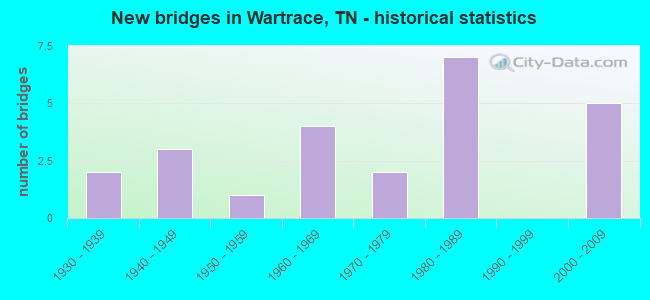
- New bridges - historical statistics
- 21930-1939
- 31940-1949
- 11950-1959
- 41960-1969
- 21970-1979
- 71980-1989
- 52000-2009
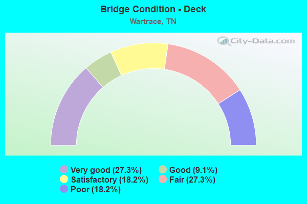
- Bridge Condition - Deck
- 27.3%Very good
- 9.1%Good
- 18.2%Satisfactory
- 27.3%Fair
- 18.2%Poor
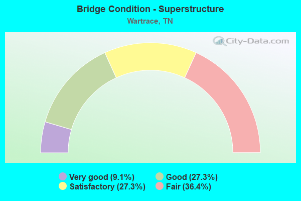
- Bridge Condition - Superstructure
- 9.1%Very good
- 27.3%Good
- 27.3%Satisfactory
- 36.4%Fair
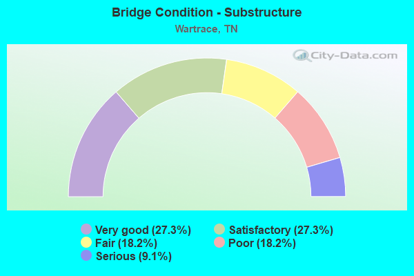
- Bridge Condition - Substructure
- 27.3%Very good
- 27.3%Satisfactory
- 18.2%Fair
- 18.2%Poor
- 9.1%Serious
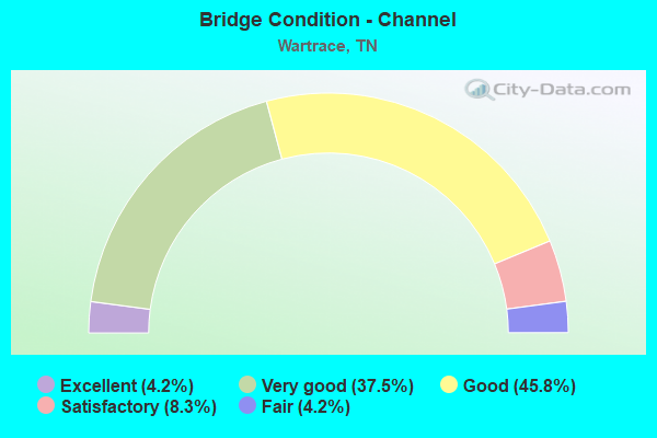
- Bridge Condition - Channel
- 4.2%Excellent
- 37.5%Very good
- 45.8%Good
- 8.3%Satisfactory
- 4.2%Fair
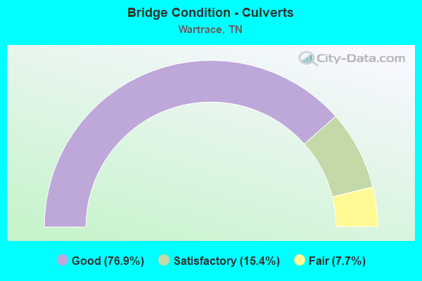
- Bridge Condition - Culverts
- 76.9%Good
- 15.4%Satisfactory
- 7.7%Fair
Find on map >> Show street view
Structure Number: 2020080009, Location: 6 M. NE. SHELBYVILLE. (Lat: 35.528767, Lng: -86.370783), Route carried "on" structure: County highway 2008, Year Built: 1984, Status: Open, Structure Length: 1.37m (4.49ft), Average Daily Traffic: 465 (year 2020), Truck Traffic: 3%, Average Future Daily Traffic: 640 (year 2041), Design Load: HS 20, Features Intersected: PANNELL CREEK
Minimum Vertical Clearance: 30+ m (98+ ft), Kilometerpoint: 9.141, Lanes on structure: 2, Owner: County Highway Agency, Approaching Roadway Width: 4.9m (16.1ft), Skew: 3 degrees, Material/Design: Concrete continuous, Design/Construction: Culvert, Number Of Spans In Main Unit: 3, Length of Maximum Span: 3.7m (12.1ft), Curb-To-Curb Width: 6.7m (22.0ft), Out-to-Out Width: 7.8m (25.6ft)
Condition: Channel: Very good, Culverts: Good, Operating Rating: 53.1 metric tons, Method Used To Determine Operating Rating: Load Factor (LF), Inventory Rating: 32.4 metric tons, Method Used To Determine Inventory Rating: Load Factor (LF), Structural Evaluation: Better than present minimum criteria, Deck Geometry: Meets minimum limits, Waterway Adequacy: Equal to present desirable criteria, Approach Roadway Alignment: Equal to present desirable criteria, Designated Inspection Frequency: Every 24 months, Inspection Date: January 2021, Deck Structure Type: Concrete Cast-file-Place, Wearing Surface/Protective System: Wearing Surface: Monolithic Concrete
Find on map >> Show street view
Structure Number: 2020100005, Location: 3.5 M. NE. WARTRACE (Lat: 35.568867, Lng: -86.291883), Route carried "on" structure: County highway 2010, Year Built: 1960, Status: Open, Structure Length: 1.25m (4.10ft), Average Daily Traffic: 804 (year 2020), Truck Traffic: 4%, Average Future Daily Traffic: 2,208 (year 2041), Features Intersected: MORGAN CREEK
Minimum Vertical Clearance: 30+ m (98+ ft), Kilometerpoint: 6.051, Lanes on structure: 2, Owner: County Highway Agency, Approaching Roadway Width: 5.5m (18.0ft), Skew: 1 degrees, Material/Design: Steel, Design/Construction: Stringer/Multi-beam, Number Of Spans In Main Unit: 2, Length of Maximum Span: 5.8m (19.0ft), Curb-To-Curb Width: 7.4m (24.3ft), Out-to-Out Width: 8.0m (26.2ft)
Condition: Deck: Satisfactory, Superstructure: Fair, Substructure: Satisfactory, Channel: Good, Operating Rating: 48.6 metric tons, Method Used To Determine Operating Rating: Load Factor (LF), Inventory Rating: 28.8 metric tons, Method Used To Determine Inventory Rating: Load Factor (LF), Structural Evaluation: Somewhat better than minimum adequacy, Deck Geometry: Meets minimum limits, Waterway Adequacy: Equal to present desirable criteria, Approach Roadway Alignment: Equal to present desirable criteria, Length Of Structure Improvement: 1.25m (4.10ft), Designated Inspection Frequency: Every 24 months, Inspection Date: Febuary 2021, Bridge Improvement Cost: $112,000, Roadway Improvement Cost: $12,000, Total Project Cost: $169,000 ( Estimate for 2021), Deck Structure Type: Concrete Cast-file-Place, Wearing Surface/Protective System: Wearing Surface: Bituminous
Find on map >> Show street view
Structure Number: 20A1290001, Location: 1.8 M. E. WARTRACE. (Lat: 35.520333, Lng: -86.300861), Route carried "on" structure: County highway 129, Year Built: 2004, Status: Open, Structure Length: 0.92m (3.02ft), Average Daily Traffic: 850 (year 2019), Truck Traffic: 2%, Average Future Daily Traffic: 1,360 (year 2041), Design Load: HS 20, Features Intersected: KNOB CREEK
Minimum Vertical Clearance: 30+ m (98+ ft), Kilometerpoint: 0.927, Lanes on structure: 2, Owner: County Highway Agency, Approaching Roadway Width: 8.5m (27.9ft), Skew: 3 degrees, Material/Design: Concrete continuous, Design/Construction: Culvert, Number Of Spans In Main Unit: 2, Length of Maximum Span: 3.7m (12.1ft), Curb-To-Curb Width: 8.4m (27.6ft), Out-to-Out Width: 14.1m (46.3ft)
Condition: Channel: Good, Culverts: Good, Operating Rating: 44.1 metric tons, Method Used To Determine Operating Rating: Assigned rating based on Load Factor Design (LFD) reported in metric tons, Inventory Rating: 32.4 metric tons, Method Used To Determine Inventory Rating: Assigned rating based on Load Factor Design (LFD) reported in metric tons, Structural Evaluation: Better than present minimum criteria, Deck Geometry: Somewhat better than minimum adequacy, Waterway Adequacy: Equal to present desirable criteria, Approach Roadway Alignment: Equal to present desirable criteria, Designated Inspection Frequency: Every 24 months, Inspection Date: January 2021, Deck Structure Type: Concrete Cast-file-Place, Wearing Surface/Protective System: Wearing Surface: Bituminous
Find on map >> Show street view
Structure Number: 20A1290003, Location: 3 M. E. WARTRACE. (Lat: 35.517267, Lng: -86.286033), Route carried "on" structure: County highway 129, Year Built: 2003, Status: Open, Structure Length: 1.16m (3.81ft), Average Daily Traffic: 850 (year 2019), Truck Traffic: 2%, Average Future Daily Traffic: 1,360 (year 2041), Design Load: HS 20, Features Intersected: KNOB CREEK
Minimum Vertical Clearance: 30+ m (98+ ft), Kilometerpoint: 2.324, Lanes on structure: 2, Owner: County Highway Agency, Approaching Roadway Width: 8.7m (28.5ft), Skew: 6 degrees, Material/Design: Concrete continuous, Design/Construction: Culvert, Number Of Spans In Main Unit: 2, Length of Maximum Span: 3.7m (12.1ft), Curb-To-Curb Width: 7.9m (25.9ft), Out-to-Out Width: 8.6m (28.2ft)
Condition: Channel: Very good, Culverts: Good, Operating Rating: 44.1 metric tons, Method Used To Determine Operating Rating: Assigned rating based on Load Factor Design (LFD) reported in metric tons, Inventory Rating: 32.4 metric tons, Method Used To Determine Inventory Rating: Assigned rating based on Load Factor Design (LFD) reported in metric tons, Structural Evaluation: Better than present minimum criteria, Deck Geometry: Somewhat better than minimum adequacy, Waterway Adequacy: Equal to present desirable criteria, Approach Roadway Alignment: Equal to present desirable criteria, Designated Inspection Frequency: Every 24 months, Inspection Date: January 2021, Deck Structure Type: Concrete Cast-file-Place, Wearing Surface/Protective System: Wearing Surface: Bituminous, Deck Protection: Epoxy Coated Reinforcing
Find on map >> Show street view
Structure Number: 20A1290005, Location: 1.5 M. E. WARTRACE (Lat: 35.521183, Lng: -86.305667), Route carried "on" structure: County highway 129, Year Built: 2001, Status: Open, Structure Length: 0.78m (2.56ft), Average Daily Traffic: 850 (year 2019), Truck Traffic: 2%, Average Future Daily Traffic: 1,360 (year 2041), Design Load: HS 20, Features Intersected: KNOB CREEK
Minimum Vertical Clearance: 30+ m (98+ ft), Kilometerpoint: 0.478, Lanes on structure: 2, Owner: County Highway Agency, Approaching Roadway Width: 5.2m (17.1ft), Skew: 4 degrees, Material/Design: Concrete continuous, Design/Construction: Culvert, Number Of Spans In Main Unit: 2, Length of Maximum Span: 3.0m (9.8ft), Curb-To-Curb Width: 8.4m (27.6ft), Out-to-Out Width: 10.2m (33.5ft)
Condition: Channel: Good, Culverts: Satisfactory, Operating Rating: 44.1 metric tons, Method Used To Determine Operating Rating: Assigned rating based on Load Factor Design (LFD) reported in metric tons, Inventory Rating: 32.4 metric tons, Method Used To Determine Inventory Rating: Assigned rating based on Load Factor Design (LFD) reported in metric tons, Structural Evaluation: Equal to present minimum criteria, Deck Geometry: Somewhat better than minimum adequacy, Waterway Adequacy: Equal to present desirable criteria, Approach Roadway Alignment: Equal to present desirable criteria, Designated Inspection Frequency: Every 24 months, Inspection Date: January 2021, Deck Structure Type: Concrete Cast-file-Place, Wearing Surface/Protective System: Wearing Surface: Monolithic Concrete, Deck Protection: Epoxy Coated Reinforcing
Find on map >> Show street view
Structure Number: 20A1420003, Location: 6 M. NE. SHELBYVILLE. (Lat: 35.531072, Lng: -86.373242), Route carried "on" structure: County highway 468, Year Built: 1960, Status: Posted for load, Structure Length: 0.91m (2.99ft), Average Daily Traffic: 130 (year 2022), Truck Traffic: 2%, Average Future Daily Traffic: 208 (year 2042), Design Load: H 15, Features Intersected: PANNELL CREEK, Facility Carried by Structure: NFA A142
Minimum Vertical Clearance: 30+ m (98+ ft), Kilometerpoint: 7.088, Lanes on structure: 2, Owner: County Highway Agency, Approaching Roadway Width: 5.8m (19.0ft), Material/Design: Steel, Design/Construction: Stringer/Multi-beam, Number Of Spans In Main Unit: 1, Length of Maximum Span: 9.1m (29.9ft), Curb-To-Curb Width: 5.5m (18.0ft), Out-to-Out Width: 5.8m (19.0ft)
Condition: Deck: Fair, Superstructure: Satisfactory, Substructure: Serious, Channel: Satisfactory, Operating Rating: 41.8 metric tons, Method Used To Determine Operating Rating: Load and Resistance Factor Rating (LRFR) rating reported by rating factor(RF) method using HL-93 loadings, Inventory Rating: 32.1 metric tons, Method Used To Determine Inventory Rating: Load and Resistance Factor Rating (LRFR) rating reported by rating factor(RF) method using HL-93 loadings, Structural Evaluation: High priority of corrective action, Deck Geometry: High priority of corrective action, Waterway Adequacy: Equal to present desirable criteria, Approach Roadway Alignment: Equal to present desirable criteria, Length Of Structure Improvement: 1.58m (5.18ft), Designated Inspection Frequency: Every 24 months, Inspection Date: January 2021, Bridge Improvement Cost: $326,000, Roadway Improvement Cost: $33,000, Total Project Cost: $490,000 ( Estimate for 2022), Deck Structure Type: Concrete Cast-file-Place, Wearing Surface/Protective System: Wearing Surface: Bituminous
Find on map >> Show street view
Structure Number: 20A1430003, Location: 2 M. W. WARTRACE. (Lat: 35.521050, Lng: -86.364617), Route carried "on" structure: County highway 143, Year Built: 1987, Status: Open, Structure Length: 1.13m (3.71ft), Average Daily Traffic: 70 (year 2022), Truck Traffic: 2%, Average Future Daily Traffic: 112 (year 2041), Design Load: HS 20, Features Intersected: PANNELL BRANCH
Minimum Vertical Clearance: 30+ m (98+ ft), Kilometerpoint: 4.863, Lanes on structure: 2, Owner: County Highway Agency, Approaching Roadway Width: 6.7m (22.0ft), Skew: 3 degrees, Material/Design: Concrete continuous, Design/Construction: Culvert, Number Of Spans In Main Unit: 2, Length of Maximum Span: 4.6m (15.1ft), Curb-To-Curb Width: 7.2m (23.6ft), Out-to-Out Width: 8.4m (27.6ft)
Condition: Channel: Very good, Culverts: Good, Operating Rating: 89.1 metric tons, Method Used To Determine Operating Rating: Load Factor (LF), Inventory Rating: 32.4 metric tons, Method Used To Determine Inventory Rating: Load Factor (LF), Structural Evaluation: Better than present minimum criteria, Deck Geometry: Somewhat better than minimum adequacy, Waterway Adequacy: Equal to present desirable criteria, Approach Roadway Alignment: Equal to present desirable criteria, Designated Inspection Frequency: Every 24 months, Inspection Date: January 2021, Deck Structure Type: Concrete Cast-file-Place, Wearing Surface/Protective System: Wearing Surface: Bituminous
Find on map >> Show street view
Structure Number: 20A1700001, Location: 3 M. NE. WARTRACE. (Lat: 35.554633, Lng: -86.281783), Route carried "on" structure: County highway 170, Year Built: 1940, Status: Posted for load, Structure Length: 1.10m (3.61ft), Average Daily Traffic: 70 (year 2022), Truck Traffic: 2%, Average Future Daily Traffic: 112 (year 2041), Design Load: H 15, Features Intersected: STRAIGHT CREEK
Minimum Vertical Clearance: 30+ m (98+ ft), Kilometerpoint: 1.147, Lanes on structure: 2, Owner: County Highway Agency, Approaching Roadway Width: 7.3m (24.0ft), Skew: 3 degrees, Material/Design: Steel, Design/Construction: Stringer/Multi-beam, Number Of Spans In Main Unit: 2, Length of Maximum Span: 5.8m (19.0ft), Curb-To-Curb Width: 6.1m (20.0ft), Out-to-Out Width: 6.7m (22.0ft)
Condition: Deck: Poor, Superstructure: Fair, Substructure: Poor, Channel: Satisfactory, Operating Rating: 32.4 metric tons, Method Used To Determine Operating Rating: Allowable Stress (AS), Inventory Rating: 25.2 metric tons, Method Used To Determine Inventory Rating: Allowable Stress (AS), Structural Evaluation: Meets minimum limits, Deck Geometry: Somewhat better than minimum adequacy, Waterway Adequacy: Equal to present desirable criteria, Approach Roadway Alignment: Equal to present minimum criteria, Length Of Structure Improvement: 1.10m (3.61ft), Designated Inspection Frequency: Every 24 months, Inspection Date: Febuary 2021, Bridge Improvement Cost: $156,000, Roadway Improvement Cost: $16,000, Total Project Cost: $235,000 ( Estimate for 2021), Deck Structure Type: Concrete Cast-file-Place, Wearing Surface/Protective System: Wearing Surface: Gravel
Find on map >> Show street view
Structure Number: 20A1870001, Location: 1 M. S. WARTRACE. (Lat: 35.510683, Lng: -86.324850), Route carried "on" structure: County highway 187, Year Built: 1960, Status: Open, Structure Length: 3.44m (11.29ft), Average Daily Traffic: 120 (year 2022), Truck Traffic: 2%, Average Future Daily Traffic: 192 (year 2041), Design Load: H 15, Features Intersected: GARRISON FORK CREEK
Minimum Vertical Clearance: 30+ m (98+ ft), Kilometerpoint: 4.410, Lanes on structure: 1, Owner: County Highway Agency, Approaching Roadway Width: 4.3m (14.1ft), Material/Design: Steel, Design/Construction: Stringer/Multi-beam, Number Of Spans In Main Unit: 3, Length of Maximum Span: 4.0m (13.1ft), Curb-To-Curb Width: 3.7m (12.1ft), Out-to-Out Width: 4.3m (14.1ft)
Condition: Deck: Fair, Superstructure: Satisfactory, Substructure: Satisfactory, Channel: Very good, Operating Rating: 32.4 metric tons, Method Used To Determine Operating Rating: Allowable Stress (AS), Inventory Rating: 24.3 metric tons, Method Used To Determine Inventory Rating: Allowable Stress (AS), Structural Evaluation: Equal to present minimum criteria, Deck Geometry: High priority of replacement, Waterway Adequacy: Meets minimum limits, Approach Roadway Alignment: High priority of corrective action, Length Of Structure Improvement: 3.44m (11.29ft), Designated Inspection Frequency: Every 24 months, Inspection Date: Febuary 2021, Bridge Improvement Cost: $366,000, Roadway Improvement Cost: $37,000, Total Project Cost: $550,000 ( Estimate for 2021), Deck Structure Type: Concrete Cast-file-Place, Wearing Surface/Protective System: Wearing Surface: Monolithic Concrete
Find on map >> Show street view
Structure Number: 20A1880001, Location: 2 M. S. WARTRACE. (Lat: 35.484917, Lng: -86.316533), Route carried "on" structure: County highway 188, Year Built: 1960, Status: Open, Structure Length: 0.79m (2.59ft), Average Daily Traffic: 270 (year 2022), Truck Traffic: 2%, Average Future Daily Traffic: 432 (year 2041), Features Intersected: DRY RUN BRANCH
Minimum Vertical Clearance: 30+ m (98+ ft), Kilometerpoint: 0.661, Lanes on structure: 2, Owner: County Highway Agency, Approaching Roadway Width: 7.3m (24.0ft), Skew: 2 degrees, Material/Design: Concrete continuous, Design/Construction: Culvert, Number Of Spans In Main Unit: 2, Length of Maximum Span: 3.0m (9.8ft), Curb-To-Curb Width: 7.2m (23.6ft), Out-to-Out Width: 7.9m (25.9ft)
Condition: Channel: Very good, Culverts: Good, Operating Rating: 38.9 metric tons, Method Used To Determine Operating Rating: Load Factor (LF), Inventory Rating: 24.3 metric tons, Method Used To Determine Inventory Rating: Load Factor (LF), Structural Evaluation: Equal to present minimum criteria, Deck Geometry: Meets minimum limits, Waterway Adequacy: Equal to present desirable criteria, Approach Roadway Alignment: Equal to present desirable criteria, Length Of Structure Improvement: 0.79m (2.59ft), Designated Inspection Frequency: Every 24 months, Inspection Date: January 2021, Bridge Improvement Cost: $46,000, Roadway Improvement Cost: $5,000, Total Project Cost: $70,000 ( Estimate for 2021)
Find on map >> Show street view
Structure Number: 20A1880003, Location: 2.1 M. S. WARTRACE. (Lat: 35.493250, Lng: -86.340017), Route carried "on" structure: County highway 188, Year Built: 2000, Status: Open, Structure Length: 5.12m (16.80ft), Average Daily Traffic: 120 (year 2022), Truck Traffic: 2%, Average Future Daily Traffic: 192 (year 2041), Design Load: HS 20, Features Intersected: GARRISON FORK CREEK
Minimum Vertical Clearance: 30+ m (98+ ft), Kilometerpoint: 3.945, Lanes on structure: 2, Owner: County Highway Agency, Approaching Roadway Width: 7.3m (24.0ft), Material/Design: Prestressed concrete continuous, Design/Construction: Box Beam or Girders - Single/Spread, Number Of Spans In Main Unit: 3, Length of Maximum Span: 17.1m (56.1ft), Curb-To-Curb Width: 7.3m (24.0ft), Out-to-Out Width: 8.0m (26.2ft)
Condition: Deck: Very good, Superstructure: Good, Substructure: Very good, Channel: Very good, Operating Rating: 59.4 metric tons, Method Used To Determine Operating Rating: Load Factor (LF), Inventory Rating: 32.4 metric tons, Method Used To Determine Inventory Rating: Load Factor (LF), Structural Evaluation: Better than present minimum criteria, Deck Geometry: Somewhat better than minimum adequacy, Waterway Adequacy: Equal to present desirable criteria, Approach Roadway Alignment: Equal to present minimum criteria, Designated Inspection Frequency: Every 24 months, Inspection Date: January 2021, Deck Structure Type: Concrete Cast-file-Place, Wearing Surface/Protective System: Wearing Surface: Monolithic Concrete, Deck Protection: Epoxy Coated Reinforcing
Find on map >> Show street view
Structure Number: 20A1970001, Location: 3 M. S. WARTRACE (Lat: 35.480167, Lng: -86.325217), Route carried "on" structure: County highway 197, Year Built: 1986, Status: Open, Structure Length: 6.89m (22.60ft), Average Daily Traffic: 170 (year 2022), Truck Traffic: 2%, Average Future Daily Traffic: 272 (year 2041), Design Load: HS 20, Features Intersected: DUCK RIVER
Minimum Vertical Clearance: 30+ m (98+ ft), Kilometerpoint: 0.016, Lanes on structure: 2, Owner: County Highway Agency, Approaching Roadway Width: 6.7m (22.0ft), Material/Design: Prestressed concrete continuous, Design/Construction: Stringer/Multi-beam, Number Of Spans In Main Unit: 3, Length of Maximum Span: 22.9m (75.1ft), Curb-To-Curb Width: 6.7m (22.0ft), Out-to-Out Width: 7.3m (24.0ft)
Condition: Deck: Satisfactory, Superstructure: Good, Substructure: Fair, Channel: Good, Operating Rating: 88.2 metric tons, Method Used To Determine Operating Rating: Load Factor (LF), Inventory Rating: 32.4 metric tons, Method Used To Determine Inventory Rating: Load Factor (LF), Structural Evaluation: Somewhat better than minimum adequacy, Deck Geometry: Meets minimum limits, Waterway Adequacy: Equal to present desirable criteria, Approach Roadway Alignment: Equal to present desirable criteria, Length Of Structure Improvement: 6.89m (22.60ft), Designated Inspection Frequency: Every 24 months, Underwater Inspection Frequency: Every 60 months, Inspection Date: January 2021, Underwater Inspection Date: June 2020, Bridge Improvement Cost: $1,033,000, Roadway Improvement Cost: $104,000, Total Project Cost: $1,550,000 ( Estimate for 2021), Deck Structure Type: Concrete Precast Panels, Wearing Surface/Protective System: Wearing Surface: Monolithic Concrete, Deck Protection: Galvanized Reinforcing
Find on map >> Show street view
Structure Number: 20A1990001, Location: 3.5 M NE JCT SR16&SR64 (Lat: 35.486033, Lng: -86.336233), Route carried "on" structure: County highway 199, Year Built: 1984, Status: Open, Structure Length: 5.49m (18.01ft), Average Daily Traffic: 250 (year 2022), Truck Traffic: 2%, Average Future Daily Traffic: 400 (year 2041), Design Load: HS 20, Features Intersected: HARRISON FORK CREEK
Minimum Vertical Clearance: 30+ m (98+ ft), Kilometerpoint: 2.589, Lanes on structure: 2, Owner: County Highway Agency, Approaching Roadway Width: 6.4m (21.0ft), Skew: 1 degrees, Material/Design: Prestressed concrete continuous, Design/Construction: Stringer/Multi-beam, Number Of Spans In Main Unit: 3, Length of Maximum Span: 18.3m (60.0ft), Curb-To-Curb Width: 7.9m (25.9ft), Out-to-Out Width: 8.6m (28.2ft)
Condition: Deck: Good, Superstructure: Very good, Substructure: Very good, Channel: Very good, Operating Rating: 52.9 metric tons, Method Used To Determine Operating Rating: Load Factor (LF), Inventory Rating: 32.4 metric tons, Method Used To Determine Inventory Rating: Load Factor (LF), Structural Evaluation: Equal to present desirable criteria, Deck Geometry: Somewhat better than minimum adequacy, Waterway Adequacy: Equal to present desirable criteria, Approach Roadway Alignment: Equal to present minimum criteria, Designated Inspection Frequency: Every 24 months, Inspection Date: January 2021, Deck Structure Type: Concrete Precast Panels, Wearing Surface/Protective System: Wearing Surface: Monolithic Concrete
Find on map >> Show street view
Structure Number: 20A6640001, Location: 1 M. S. WARTRACE. (Lat: 35.511550, Lng: -86.337117), Route carried "on" structure: County highway 664, Year Built: 1940, Status: Posted for load, Structure Length: 2.96m (9.71ft), Average Daily Traffic: 20 (year 2022), Truck Traffic: 2%, Average Future Daily Traffic: 32 (year 2042), Design Load: H 10, Features Intersected: STOKES BRANCH
Minimum Vertical Clearance: 30+ m (98+ ft), Kilometerpoint: 0.182, Lanes on structure: 2, Owner: County Highway Agency, Approaching Roadway Width: 4.6m (15.1ft), Material/Design: Steel, Design/Construction: Stringer/Multi-beam, Number Of Spans In Main Unit: 2, Length of Maximum Span: 14.6m (47.9ft), Curb-To-Curb Width: 6.1m (20.0ft), Out-to-Out Width: 6.4m (21.0ft)
Condition: Deck: Very good, Superstructure: Fair, Substructure: Poor, Channel: Good, Operating Rating: 13.6 metric tons, Method Used To Determine Operating Rating: Load and Resistance Factor Rating (LRFR) rating reported by rating factor(RF) method using HL-93 loadings, Inventory Rating: 10.4 metric tons, Method Used To Determine Inventory Rating: Load and Resistance Factor Rating (LRFR) rating reported by rating factor(RF) method using HL-93 loadings, Structural Evaluation: High priority of replacement, Deck Geometry: Somewhat better than minimum adequacy, Waterway Adequacy: Equal to present desirable criteria, Approach Roadway Alignment: Equal to present desirable criteria, Bridge Posting: Required (Relationship of Operating Rating to Maximum Legal Load: 0.1 - 9.9% below), Length Of Structure Improvement: 3.86m (12.66ft), Designated Inspection Frequency: Every 24 months, Inspection Date: Febuary 2021, Bridge Improvement Cost: $668,000, Roadway Improvement Cost: $67,000, Total Project Cost: $1,003,000 ( Estimate for 2022), Deck Structure Type: Wood or Timber, Wearing Surface/Protective System: Wearing Surface: Bituminous
Find on map >> Show street view
Structure Number: 2E00290029, Location: .4 MI.S.OF WARTRACE (Lat: 35.520556, Lng: -86.318358), Route carried "on" structure: State highway 269, Year Built: 1940, Status: Posted for load, Structure Length: 5.18m (16.99ft), Average Daily Traffic: 1,307 (year 2020), Truck Traffic: 4%, Average Future Daily Traffic: 2,464 (year 2040), Design Load: H 15, Features Intersected: GARRISON FORK CREEK
Minimum Vertical Clearance: 30+ m (98+ ft), Kilometerpoint: 17.075, Lanes on structure: 2, Owner: State Highway Agency, Approaching Roadway Width: 7.3m (24.0ft), Skew: 3 degrees, Material/Design: Steel, Design/Construction: Stringer/Multi-beam, Number Of Spans In Main Unit: 4, Length of Maximum Span: 15.8m (51.8ft), Curb-To-Curb Width: 6.1m (20.0ft), Out-to-Out Width: 6.9m (22.6ft)
Condition: Deck: Poor, Superstructure: Fair, Substructure: Fair, Channel: Good, Operating Rating: 38.7 metric tons, Method Used To Determine Operating Rating: Load Factor (LF), Inventory Rating: 23.4 metric tons, Method Used To Determine Inventory Rating: Load Factor (LF), Structural Evaluation: Somewhat better than minimum adequacy, Deck Geometry: High priority of replacement, Waterway Adequacy: Equal to present desirable criteria, Approach Roadway Alignment: Equal to present minimum criteria, Length Of Structure Improvement: 5.18m (16.99ft), Designated Inspection Frequency: Every 24 months, Inspection Date: October 2020, Bridge Improvement Cost: $547,000, Roadway Improvement Cost: $55,000, Total Project Cost: $821,000 ( Estimate for 2020), Deck Structure Type: Concrete Cast-file-Place, Wearing Surface/Protective System: Wearing Surface: Bituminous
Find on map >> Show street view
Structure Number: 2E00290031, Location: 2 MI. SOUTH OF WARTRACE (Lat: 35.509400, Lng: -86.304786), Route carried "on" structure: State highway 269, Year Built: 1952, Status: Open, Structure Length: 0.98m (3.22ft), Average Daily Traffic: 733 (year 2020), Truck Traffic: 4%, Average Future Daily Traffic: 1,008 (year 2041), Design Load: H 15, Features Intersected: BRANCH
Minimum Vertical Clearance: 30+ m (98+ ft), Kilometerpoint: 19.554, Lanes on structure: 2, Owner: State Highway Agency, Approaching Roadway Width: 7.3m (24.0ft), Skew: 4 degrees, Material/Design: Concrete, Design/Construction: Culvert, Number Of Spans In Main Unit: 1, Length of Maximum Span: 3.0m (9.8ft), Curb-To-Curb Width: 6.2m (20.3ft), Out-to-Out Width: 7.0m (23.0ft)
Condition: Channel: Fair, Culverts: Good, Operating Rating: 51.8 metric tons, Method Used To Determine Operating Rating: Load Factor (LF), Inventory Rating: 24.3 metric tons, Method Used To Determine Inventory Rating: Load Factor (LF), Structural Evaluation: Equal to present minimum criteria, Deck Geometry: High priority of corrective action, Waterway Adequacy: Equal to present desirable criteria, Approach Roadway Alignment: Equal to present desirable criteria, Length Of Structure Improvement: 0.98m (3.22ft), Designated Inspection Frequency: Every 24 months, Inspection Date: October 2020, Bridge Improvement Cost: $85,000, Roadway Improvement Cost: $9,000, Total Project Cost: $128,000 ( Estimate for 2021), Deck Structure Type: Concrete Cast-file-Place, Wearing Surface/Protective System: Wearing Surface: Bituminous
Find on map >> Show street view
Structure Number: 2S42890011, Location: .9 MILE SOUTH OF WARTRACE (Lat: 35.519083, Lng: -86.310056), Route carried "on" structure: State highway 269, Year Built: 2005, Status: Open, Structure Length: 1.94m (6.36ft), Average Daily Traffic: 733 (year 2020), Truck Traffic: 4%, Average Future Daily Traffic: 1,008 (year 2041), Design Load: HS 20, Features Intersected: KNOB CREEK
Minimum Vertical Clearance: 30+ m (98+ ft), Kilometerpoint: 17.864, Lanes on structure: 2, Owner: State Highway Agency, Approaching Roadway Width: 7.9m (25.9ft), Skew: 1 degrees, Material/Design: Concrete continuous, Design/Construction: Culvert, Number Of Spans In Main Unit: 3, Length of Maximum Span: 6.4m (21.0ft), Curb-To-Curb Width: 12.6m (41.3ft), Out-to-Out Width: 22.0m (72.2ft)
Condition: Channel: Good, Culverts: Satisfactory, Operating Rating: 44.1 metric tons, Method Used To Determine Operating Rating: Assigned rating based on Load Factor Design (LFD) reported in metric tons, Inventory Rating: 32.4 metric tons, Method Used To Determine Inventory Rating: Assigned rating based on Load Factor Design (LFD) reported in metric tons, Structural Evaluation: Equal to present minimum criteria, Deck Geometry: Superior to present desirable criteria, Waterway Adequacy: Equal to present desirable criteria, Approach Roadway Alignment: Equal to present minimum criteria, Designated Inspection Frequency: Every 24 months, Inspection Date: October 2020, Deck Structure Type: Concrete Cast-file-Place, Wearing Surface/Protective System: Wearing Surface: Bituminous
Find on map >> Show street view
Structure Number: 2S42890015, Location: IN WARTRACE CITY LIMITS (Lat: 35.527739, Lng: -86.340258), Route carried "on" structure: State highway 269, Year Built: 1930, Status: Posted for load, Structure Length: 6.86m (22.51ft), Average Daily Traffic: 1,290 (year 2020), Truck Traffic: 4%, Average Future Daily Traffic: 1,760 (year 2041), Design Load: H 15, Features Intersected: WARTRACE CREEK
Minimum Vertical Clearance: 30+ m (98+ ft), Kilometerpoint: 14.677, Lanes on structure: 2, Owner: State Highway Agency, Approaching Roadway Width: 7.3m (24.0ft), Skew: 1 degrees, Material/Design: Concrete, Design/Construction: Tee Beam, Number Of Spans In Main Unit: 6, Length of Maximum Span: 13.1m (43.0ft), Curb-To-Curb Width: 6.7m (22.0ft), Out-to-Out Width: 8.1m (26.6ft)
Condition: Deck: Fair, Superstructure: Satisfactory, Substructure: Satisfactory, Channel: Good, Operating Rating: 32.4 metric tons, Method Used To Determine Operating Rating: Load Factor (LF), Inventory Rating: 19.8 metric tons, Method Used To Determine Inventory Rating: Load Factor (LF), Structural Evaluation: Somewhat better than minimum adequacy, Deck Geometry: High priority of corrective action, Waterway Adequacy: Equal to present desirable criteria, Approach Roadway Alignment: Equal to present minimum criteria, Length Of Structure Improvement: 6.86m (22.51ft), Designated Inspection Frequency: Every 24 months, Inspection Date: October 2020, Bridge Improvement Cost: $483,000, Roadway Improvement Cost: $49,000, Total Project Cost: $725,000 ( Estimate for 2021), Deck Structure Type: Concrete Cast-file-Place, Wearing Surface/Protective System: Wearing Surface: Bituminous
Find on map >> Show street view
Structure Number: 2S42890017, Location: 1.1 MI.N.OF WARTRACE (Lat: 35.539767, Lng: -86.346578), Route carried "on" structure: State highway 269, Year Built: 1930, Status: Open, Structure Length: 0.98m (3.22ft), Average Daily Traffic: 1,290 (year 2020), Truck Traffic: 4%, Average Future Daily Traffic: 1,760 (year 2041), Design Load: H 15, Features Intersected: HURRICANE CREEK
Minimum Vertical Clearance: 30+ m (98+ ft), Kilometerpoint: 13.068, Lanes on structure: 2, Owner: State Highway Agency, Approaching Roadway Width: 7.9m (25.9ft), Material/Design: Concrete continuous, Design/Construction: Culvert, Number Of Spans In Main Unit: 2, Length of Maximum Span: 4.6m (15.1ft), Curb-To-Curb Width: 7.3m (24.0ft), Out-to-Out Width: 8.0m (26.2ft)
Condition: Channel: Very good, Culverts: Good, Operating Rating: 69.3 metric tons, Method Used To Determine Operating Rating: Load Factor (LF), Inventory Rating: 24.3 metric tons, Method Used To Determine Inventory Rating: Load Factor (LF), Structural Evaluation: Equal to present minimum criteria, Deck Geometry: Meets minimum limits, Waterway Adequacy: Equal to present desirable criteria, Approach Roadway Alignment: Equal to present minimum criteria, Length Of Structure Improvement: 0.98m (3.22ft), Designated Inspection Frequency: Every 24 months, Inspection Date: October 2020, Bridge Improvement Cost: $92,000, Roadway Improvement Cost: $10,000, Total Project Cost: $139,000 ( Estimate for 2021), Deck Structure Type: Concrete Cast-file-Place, Wearing Surface/Protective System: Wearing Surface: Bituminous
Find on map >> Show street view
Structure Number: 2SR0640029, Location: .8 MI.S.OF WARTRACE (Lat: 35.510083, Lng: -86.336572), Route carried "on" structure: State highway 64, Year Built: 1976, Status: Open, Structure Length: 1.16m (3.81ft), Average Daily Traffic: 2,850 (year 2020), Truck Traffic: 7%, Average Future Daily Traffic: 4,688 (year 2041), Design Load: HS 20, Features Intersected: STOKES BRANCH
Minimum Vertical Clearance: 30+ m (98+ ft), Kilometerpoint: 33.024, Lanes on structure: 2, Base Highway Network: Yes (Inventory Route: 2SR0640, Subroute: 2), Owner: State Highway Agency, Approaching Roadway Width: 12.8m (42.0ft), Material/Design: Concrete continuous, Design/Construction: Culvert, Number Of Spans In Main Unit: 2, Length of Maximum Span: 3.7m (12.1ft)
Condition: Channel: Good, Culverts: Good, Operating Rating: 44.1 metric tons, Method Used To Determine Operating Rating: Load Factor (LF), Inventory Rating: 32.4 metric tons, Method Used To Determine Inventory Rating: Load Factor (LF), Structural Evaluation: Better than present minimum criteria, Waterway Adequacy: Equal to present desirable criteria, Approach Roadway Alignment: Equal to present desirable criteria, Designated Inspection Frequency: Every 24 months, Inspection Date: October 2020
Find on map >> Show street view
Structure Number: 2SR0640031, Location: .1 MI.W.OF WARTRACE (Lat: 35.519714, Lng: -86.334236), Route carried "on" structure: State highway 64, Year Built: 1979, Status: Posted for load, Structure Length: 6.61m (21.69ft), Average Daily Traffic: 2,850 (year 2020), Truck Traffic: 7%, Average Future Daily Traffic: 4,560 (year 2041), Design Load: H 15, Features Intersected: WARTRACE CREEK
Minimum Vertical Clearance: 30+ m (98+ ft), Kilometerpoint: 34.070, Lanes on structure: 2, Base Highway Network: Yes (Inventory Route: 2SR0640, Subroute: 2), Owner: State Highway Agency, Approaching Roadway Width: 13.4m (44.0ft), Material/Design: Prestressed concrete continuous, Design/Construction: Stringer/Multi-beam, Number Of Spans In Main Unit: 4, Length of Maximum Span: 20.4m (66.9ft), Curb-To-Curb Width: 14.6m (47.9ft), Out-to-Out Width: 15.8m (51.8ft)
Condition: Deck: Very good, Superstructure: Good, Substructure: Very good, Channel: Very good, Operating Rating: 22.4 metric tons, Method Used To Determine Operating Rating: Load and Resistance Factor Rating (LRFR) rating reported by rating factor(RF) method using HL-93 loadings, Inventory Rating: 17.2 metric tons, Method Used To Determine Inventory Rating: Load and Resistance Factor Rating (LRFR) rating reported by rating factor(RF) method using HL-93 loadings, Structural Evaluation: Meets minimum limits, Deck Geometry: Superior to present desirable criteria, Waterway Adequacy: Equal to present desirable criteria, Approach Roadway Alignment: Equal to present desirable criteria, Designated Inspection Frequency: Every 24 months, Inspection Date: October 2020, Deck Structure Type: Concrete Precast Panels, Wearing Surface/Protective System: Wearing Surface: Bituminous, Membrane: Built-up
Find on map >> Show street view
Structure Number: 2SR0640033, Location: 2.8 MI.N.OF WARTRACE (Lat: 35.554258, Lng: -86.299228), Route carried "on" structure: State highway 64, Year Built: 1983, Status: Open, Structure Length: 1.07m (3.51ft), Average Daily Traffic: 1,664 (year 2020), Truck Traffic: 11%, Average Future Daily Traffic: 2,864 (year 2041), Design Load: HS 20, Features Intersected: BATES BRANCH
Minimum Vertical Clearance: 30+ m (98+ ft), Kilometerpoint: 40.057, Lanes on structure: 2, Base Highway Network: Yes (Inventory Route: 2SR0640, Subroute: 2), Owner: State Highway Agency, Approaching Roadway Width: 9.1m (29.9ft), Skew: 1 degrees, Material/Design: Concrete continuous, Design/Construction: Culvert, Number Of Spans In Main Unit: 2, Length of Maximum Span: 4.6m (15.1ft)
Condition: Channel: Excellent, Culverts: Fair, Operating Rating: 54.0 metric tons, Method Used To Determine Operating Rating: Field evaluation and documented engineering judgment, Inventory Rating: 32.4 metric tons, Method Used To Determine Inventory Rating: Field evaluation and documented engineering judgment, Structural Evaluation: Somewhat better than minimum adequacy, Waterway Adequacy: Equal to present desirable criteria, Approach Roadway Alignment: Equal to present desirable criteria, Length Of Structure Improvement: 1.07m (3.51ft), Designated Inspection Frequency: Every 24 months, Inspection Date: October 2020, Bridge Improvement Cost: $198,000, Roadway Improvement Cost: $20,000, Total Project Cost: $298,000 ( Estimate for 2021)
Find on map >> Show street view
Structure Number: 2SR0640035, Location: 11.9 MI.NE.OF SHELBYVILLE (Lat: 35.565511, Lng: -86.286328), Route carried "on" structure: State highway 64, Year Built: 1983, Status: Open, Structure Length: 1.58m (5.18ft), Average Daily Traffic: 1,664 (year 2020), Truck Traffic: 11%, Average Future Daily Traffic: 2,864 (year 2041), Design Load: HS 20, Features Intersected: MORGAN BRANCH
Minimum Vertical Clearance: 30+ m (98+ ft), Kilometerpoint: 41.843, Lanes on structure: 2, Base Highway Network: Yes (Inventory Route: 2SR0640, Subroute: 2), Owner: State Highway Agency, Approaching Roadway Width: 11.3m (37.1ft), Skew: 1 degrees, Material/Design: Concrete continuous, Design/Construction: Culvert, Number Of Spans In Main Unit: 3, Length of Maximum Span: 4.6m (15.1ft), Curb-To-Curb Width: 11.6m (38.1ft), Out-to-Out Width: 13.0m (42.7ft)
Condition: Channel: Good, Culverts: Good, Operating Rating: 56.7 metric tons, Method Used To Determine Operating Rating: Load Factor (LF), Inventory Rating: 32.4 metric tons, Method Used To Determine Inventory Rating: Load Factor (LF), Structural Evaluation: Better than present minimum criteria, Deck Geometry: Equal to present minimum criteria, Waterway Adequacy: Equal to present desirable criteria, Approach Roadway Alignment: Equal to present desirable criteria, Designated Inspection Frequency: Every 24 months, Inspection Date: October 2020, Deck Structure Type: Concrete Cast-file-Place, Wearing Surface/Protective System: Wearing Surface: Bituminous
Find on map >> Show street view
Structure Number: 2SR0640045, Location: 5 M. NE. WARTRACE (Lat: 35.559253, Lng: -86.290550), Route carried "on" structure: State highway 64, Year Built: 1988, Status: Open, Structure Length: 0.73m (2.40ft), Average Daily Traffic: 1,664 (year 2020), Truck Traffic: 11%, Average Future Daily Traffic: 2,864 (year 2041), Design Load: HS 20, Features Intersected: HAWKINS BRANCH
Minimum Vertical Clearance: 30+ m (98+ ft), Kilometerpoint: 41.055, Lanes on structure: 2, Base Highway Network: Yes (Inventory Route: 2SR0640, Subroute: 2), Owner: State Highway Agency, Approaching Roadway Width: 8.5m (27.9ft), Material/Design: Concrete, Design/Construction: Culvert, Number Of Spans In Main Unit: 2, Length of Maximum Span: 3.0m (9.8ft)
Condition: Channel: Good, Culverts: Good, Operating Rating: 54.0 metric tons, Method Used To Determine Operating Rating: Field evaluation and documented engineering judgment, Inventory Rating: 32.4 metric tons, Method Used To Determine Inventory Rating: Field evaluation and documented engineering judgment, Structural Evaluation: Better than present minimum criteria, Waterway Adequacy: Equal to present desirable criteria, Approach Roadway Alignment: Equal to present desirable criteria, Designated Inspection Frequency: Every 24 months, Inspection Date: October 2020