Bridge Statistics for Washington, Iowa (IA)
Condition, Traffic, Stress, Structural Evaluation, Project Costs
- National Bridge Inventory (NBI) Statistics
- 29Number of bridges
- 230ft / 69.6mTotal length
- 31,715Total average daily traffic
- 2,346Total average daily truck traffic
- 31,715Total future (year 2039) average daily traffic
- National Bridge Inventory (NBI) Registered Bridges for Washington
- No street view available for this location
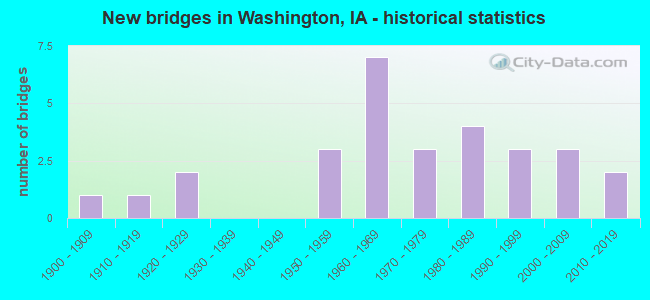
- New bridges - historical statistics
- 11900-1909
- 11910-1919
- 21920-1929
- 31950-1959
- 71960-1969
- 31970-1979
- 41980-1989
- 31990-1999
- 32000-2009
- 22010-2019
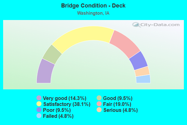
- Bridge Condition - Deck
- 14.3%Very good
- 9.5%Good
- 38.1%Satisfactory
- 19.0%Fair
- 9.5%Poor
- 4.8%Serious
- 4.8%Failed
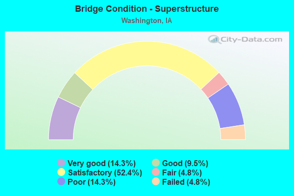
- Bridge Condition - Superstructure
- 14.3%Very good
- 9.5%Good
- 52.4%Satisfactory
- 4.8%Fair
- 14.3%Poor
- 4.8%Failed
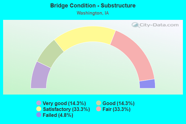
- Bridge Condition - Substructure
- 14.3%Very good
- 14.3%Good
- 33.3%Satisfactory
- 33.3%Fair
- 4.8%Failed
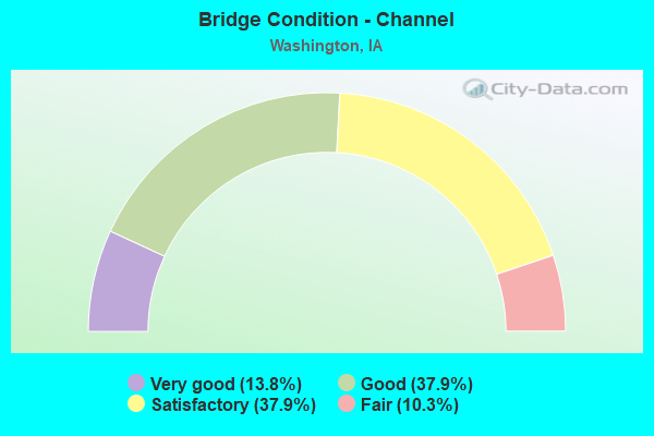
- Bridge Condition - Channel
- 13.8%Very good
- 37.9%Good
- 37.9%Satisfactory
- 10.3%Fair
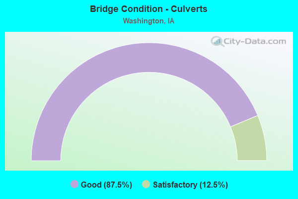
- Bridge Condition - Culverts
- 87.5%Good
- 12.5%Satisfactory
Find on map >> Show street view
Structure Number: 51621, Location: 3.4 mi. S of S Jct. IA 92 (Lat: 41.261156, Lng: -91.749153), Route carried "on" structure: State highway 1, Year Built: 1987, Status: Open, Structure Length: 1.16m (3.81ft), Average Daily Traffic: 2,220 (year 2020), Truck Traffic: 11%, Average Future Daily Traffic: 2,220 (year 2041), Design Load: HS 20, Features Intersected: CEDAR CREEK
Minimum Vertical Clearance: 30+ m (98+ ft), Kilometerpoint: 82.592, Lanes on structure: 2, Base Highway Network: Yes, Owner: State Highway Agency, Approaching Roadway Width: 13.4m (44.0ft), Material/Design: Concrete continuous, Design/Construction: Culvert, Number Of Spans In Main Unit: 3, Length of Maximum Span: 3.7m (12.1ft)
Condition: Channel: Fair, Culverts: Good, Operating Rating: 37.9 metric tons, Method Used To Determine Operating Rating: Load and Resistance Factor Rating (LRFR) rating reported by rating factor(RF) method using HL-93 loadings, Inventory Rating: 29.2 metric tons, Method Used To Determine Inventory Rating: Load and Resistance Factor Rating (LRFR) rating reported by rating factor(RF) method using HL-93 loadings, Structural Evaluation: Better than present minimum criteria, Waterway Adequacy: Equal to present minimum criteria, Approach Roadway Alignment: Equal to present minimum criteria, Designated Inspection Frequency: Every 24 months, Inspection Date: Febuary 2021
Find on map >> Show street view
Structure Number: 51631, Location: 1.2 miles South of IA 92 (Lat: 41.281478, Lng: -91.716258), Route carried "on" structure: State highway 1, Year Built: 2016, Status: Open, Structure Length: 7.85m (25.75ft), Average Daily Traffic: 2,550 (year 2020), Truck Traffic: 10%, Average Future Daily Traffic: 2,550 (year 2040), Design Load: HL 93, Features Intersected: WEST FORK CROOKED CREEK
Minimum Vertical Clearance: 30+ m (98+ ft), Kilometerpoint: 86.261, Lanes on structure: 2, Base Highway Network: Yes, Owner: State Highway Agency, Approaching Roadway Width: 13.4m (44.0ft), Skew: 3 degrees, Material/Design: Prestressed concrete, Design/Construction: Stringer/Multi-beam, Number Of Spans In Main Unit: 3, Length of Maximum Span: 28.0m (91.9ft), Curb-To-Curb Width: 13.4m (44.0ft), Out-to-Out Width: 14.4m (47.2ft)
Condition: Deck: Good, Superstructure: Good, Substructure: Good, Channel: Good, Operating Rating: 42.1 metric tons, Method Used To Determine Operating Rating: Assigned ratings based on Load and Resistance Factor Design (LRFD) reported by rating factor (RF) using HL93 loadings, Inventory Rating: 32.4 metric tons, Method Used To Determine Inventory Rating: Assigned ratings based on Load and Resistance Factor Design (LRFD) reported by rating factor (RF) using HL93 loadings, Structural Evaluation: Better than present minimum criteria, Deck Geometry: Better than present minimum criteria, Waterway Adequacy: Superior to present desirable criteria, Approach Roadway Alignment: Equal to present desirable criteria, Designated Inspection Frequency: Every 24 months, Inspection Date: April 2020, Deck Structure Type: Concrete Cast-file-Place, Wearing Surface/Protective System: Wearing Surface: Monolithic Concrete, Deck Protection: Epoxy Coated Reinforcing
Find on map >> Show street view
Structure Number: 51651, Location: 1.0 mi. N of Jct. SR G36 (Lat: 41.351492, Lng: -91.715733), Route carried "on" structure: State highway 1, Year Built: 1987, Status: Open, Structure Length: 0.88m (2.89ft), Average Daily Traffic: 3,330 (year 2020), Truck Traffic: 18%, Average Future Daily Traffic: 3,330 (year 2041), Design Load: HS 20, Features Intersected: LONG CREEK
Minimum Vertical Clearance: 30+ m (98+ ft), Kilometerpoint: 94.716, Lanes on structure: 2, Base Highway Network: Yes, Owner: State Highway Agency, Approaching Roadway Width: 13.4m (44.0ft), Skew: 3 degrees, Material/Design: Concrete continuous, Design/Construction: Culvert, Number Of Spans In Main Unit: 2, Length of Maximum Span: 3.7m (12.1ft)
Condition: Channel: Good, Culverts: Good, Operating Rating: 65.3 metric tons, Method Used To Determine Operating Rating: Load Factor (LF), Inventory Rating: 39.1 metric tons, Method Used To Determine Inventory Rating: Load Factor (LF), Structural Evaluation: Better than present minimum criteria, Waterway Adequacy: Equal to present minimum criteria, Approach Roadway Alignment: Better than present minimum criteria, Designated Inspection Frequency: Every 24 months, Inspection Date: Febuary 2021
Find on map >> Show street view
Structure Number: 5182, Location: 4.6 MI. W OF JCT. US 218 (Lat: 41.294886, Lng: -91.621347), Route carried "on" structure: State highway 92, Year Built: 1967, Status: Open, Structure Length: 4.05m (13.29ft), Average Daily Traffic: 6,300 (year 2020), Truck Traffic: 7%, Average Future Daily Traffic: 6,300 (year 2040), Design Load: HS 20, Features Intersected: SOUTH LONG CREEK
Minimum Vertical Clearance: 30+ m (98+ ft), Kilometerpoint: 380.264, Lanes on structure: 2, Base Highway Network: Yes, Owner: State Highway Agency, Approaching Roadway Width: 13.4m (44.0ft), Skew: 4 degrees, Material/Design: Concrete continuous, Design/Construction: Slab, Number Of Spans In Main Unit: 3, Length of Maximum Span: 15.5m (50.9ft), Curb-To-Curb Width: 13.4m (44.0ft), Out-to-Out Width: 14.4m (47.2ft)
Condition: Deck: Satisfactory, Superstructure: Satisfactory, Substructure: Satisfactory, Channel: Satisfactory, Operating Rating: 62.8 metric tons, Method Used To Determine Operating Rating: Load Factor (LF), Inventory Rating: 37.6 metric tons, Method Used To Determine Inventory Rating: Load Factor (LF), Structural Evaluation: Equal to present minimum criteria, Deck Geometry: Equal to present minimum criteria, Waterway Adequacy: Equal to present minimum criteria, Approach Roadway Alignment: Equal to present minimum criteria, Designated Inspection Frequency: Every 24 months, Inspection Date: November 2020, Deck Structure Type: Concrete Cast-file-Place, Wearing Surface/Protective System: Wearing Surface: Low Slump Concrete
Find on map >> Show street view
Structure Number: 335671, Location: 074070504 (Lat: 41.246650, Lng: -91.679756), Route carried "on" structure: County highway , Year Built: 2002, Status: Open, Structure Length: 8.72m (28.61ft), Average Daily Traffic: 1,720 (year 2018), Truck Traffic: 7%, Average Future Daily Traffic: 1,720 (year 2041), Design Load: HS 20, Features Intersected: W FORK CROOKED CREEK, Facility Carried by Structure: W55 WAYLAND RD
Minimum Vertical Clearance: 30+ m (98+ ft), Kilometerpoint: 9.848, Lanes on structure: 2, Owner: County Highway Agency, Approaching Roadway Width: 14.6m (47.9ft), Skew: 1 degrees, Material/Design: Prestressed concrete, Design/Construction: Stringer/Multi-beam, Number Of Spans In Main Unit: 3, Length of Maximum Span: 34.1m (111.9ft), Curb-To-Curb Width: 9.1m (29.9ft), Out-to-Out Width: 10.0m (32.8ft)
Condition: Deck: Very good, Superstructure: Very good, Substructure: Very good, Channel: Very good, Operating Rating: 69.6 metric tons, Method Used To Determine Operating Rating: Load Factor (LF), Inventory Rating: 41.6 metric tons, Method Used To Determine Inventory Rating: Load Factor (LF), Structural Evaluation: Equal to present desirable criteria, Deck Geometry: Somewhat better than minimum adequacy, Waterway Adequacy: Equal to present desirable criteria, Approach Roadway Alignment: Equal to present desirable criteria, Length Of Structure Improvement: 28.60m (93.83ft), Designated Inspection Frequency: Every 24 months, Inspection Date: March 2021, Bridge Improvement Cost: $15,000, Roadway Improvement Cost: $2,000, Deck Structure Type: Concrete Cast-file-Place, Wearing Surface/Protective System: Wearing Surface: Monolithic Concrete
Find on map >> Show street view
Structure Number: 3363, Location: 075070102 (Lat: 41.333844, Lng: -91.619497), Route carried "on" structure: County highway , Year Built: 1917, Status: Posted for load, Structure Length: 0.98m (3.22ft), Average Daily Traffic: 10 (year 2018), Average Future Daily Traffic: 10 (year 2041), Features Intersected: SMALL STREAM, Facility Carried by Structure: LOCAL ROAD
Minimum Vertical Clearance: 30+ m (98+ ft), Kilometerpoint: 10.832, Lanes on structure: 2, Owner: County Highway Agency, Approaching Roadway Width: 7.3m (24.0ft), Material/Design: Steel, Design/Construction: Stringer/Multi-beam, Number Of Spans In Main Unit: 1, Length of Maximum Span: 9.1m (29.9ft), Curb-To-Curb Width: 5.6m (18.4ft), Out-to-Out Width: 6.1m (20.0ft)
Condition: Deck: Poor, Superstructure: Poor, Substructure: Fair, Channel: Fair, Operating Rating: 35.6 metric tons, Method Used To Determine Operating Rating: Allowable Stress (AS), Inventory Rating: 21.0 metric tons, Method Used To Determine Inventory Rating: Allowable Stress (AS), Structural Evaluation: Meets minimum limits, Deck Geometry: Meets minimum limits, Waterway Adequacy: Somewhat better than minimum adequacy, Approach Roadway Alignment: Equal to present minimum criteria, Bridge Posting: Required (Relationship of Operating Rating to Maximum Legal Load: 0.1 - 9.9% below), Length Of Structure Improvement: 7.50m (24.61ft), Designated Inspection Frequency: Every 24 months, Inspection Date: March 2021, Bridge Improvement Cost: $214,000, Roadway Improvement Cost: $21,000, Deck Structure Type: Concrete Cast-file-Place, Wearing Surface/Protective System: Wearing Surface: Monolithic Concrete
Find on map >> Show street view
Structure Number: 33632, Location: 075070201 (Lat: 41.337819, Lng: -91.621858), Route carried "on" structure: County highway , Year Built: 1966, Year Reconstructed: 1984, Status: Open, Structure Length: 0.67m (2.20ft), Average Daily Traffic: 3,110 (year 2018), Truck Traffic: 6%, Average Future Daily Traffic: 3,110 (year 2039), Design Load: H 20, Features Intersected: SMALL STREAM, Facility Carried by Structure: FM
Minimum Vertical Clearance: 30+ m (98+ ft), Kilometerpoint: 7.924, Lanes on structure: 2, Owner: County Highway Agency, Approaching Roadway Width: 14.0m (45.9ft), Skew: 1 degrees, Material/Design: Concrete continuous, Design/Construction: Culvert, Number Of Spans In Main Unit: 2, Length of Maximum Span: 3.0m (9.8ft)
Condition: Channel: Good, Culverts: Satisfactory, Inventory Rating: 70.3 metric tons, Method Used To Determine Inventory Rating: Load Factor (LF), Structural Evaluation: Equal to present minimum criteria, Waterway Adequacy: Equal to present desirable criteria, Approach Roadway Alignment: Better than present minimum criteria, Length Of Structure Improvement: 2.20m (7.22ft), Designated Inspection Frequency: Every 48 months, Inspection Date: Febuary 2019, Bridge Improvement Cost: $15,000, Roadway Improvement Cost: $2,000
Find on map >> Show street view
Structure Number: 336341, Location: 075070301 (Lat: 41.337708, Lng: -91.656133), Route carried "on" structure: County highway , Year Built: 1985, Status: Open, Structure Length: 1.19m (3.90ft), Average Daily Traffic: 3,110 (year 2018), Truck Traffic: 6%, Average Future Daily Traffic: 3,110 (year 2039), Design Load: HS 20, Features Intersected: N.FORK LONG CREEK, Facility Carried by Structure: FM
Minimum Vertical Clearance: 30+ m (98+ ft), Kilometerpoint: 5.057, Lanes on structure: 2, Owner: County Highway Agency, Approaching Roadway Width: 14.0m (45.9ft), Material/Design: Concrete continuous, Design/Construction: Culvert, Number Of Spans In Main Unit: 3, Length of Maximum Span: 3.7m (12.1ft)
Condition: Channel: Good, Culverts: Good, Operating Rating: 44.1 metric tons, Method Used To Determine Operating Rating: Assigned rating based on Load Factor Design (LFD) reported in metric tons, Inventory Rating: 32.7 metric tons, Method Used To Determine Inventory Rating: Assigned rating based on Load Factor Design (LFD) reported in metric tons, Structural Evaluation: Better than present minimum criteria, Waterway Adequacy: Better than present minimum criteria, Approach Roadway Alignment: Better than present minimum criteria, Length Of Structure Improvement: 3.90m (12.80ft), Designated Inspection Frequency: Every 48 months, Inspection Date: Febuary 2019, Bridge Improvement Cost: $15,000, Roadway Improvement Cost: $2,000
Find on map >> Show street view
Structure Number: 336361, Location: 075070404 (Lat: 41.327506, Lng: -91.677931), Route carried "on" structure: County highway , Year Built: 1996, Status: Open, Structure Length: 0.88m (2.89ft), Average Daily Traffic: 3,760 (year 2018), Truck Traffic: 7%, Average Future Daily Traffic: 3,760 (year 2041), Design Load: HS 20, Features Intersected: S. FORK LONG CREEK, Facility Carried by Structure: FM
Minimum Vertical Clearance: 30+ m (98+ ft), Kilometerpoint: 2.034, Lanes on structure: 2, Owner: County Highway Agency, Approaching Roadway Width: 18.3m (60.0ft), Material/Design: Concrete continuous, Design/Construction: Culvert, Number Of Spans In Main Unit: 2, Length of Maximum Span: 4.3m (14.1ft)
Condition: Channel: Good, Culverts: Good, Operating Rating: 44.1 metric tons, Method Used To Determine Operating Rating: Assigned rating based on Load Factor Design (LFD) reported in metric tons, Inventory Rating: 32.7 metric tons, Method Used To Determine Inventory Rating: Assigned rating based on Load Factor Design (LFD) reported in metric tons, Structural Evaluation: Better than present minimum criteria, Waterway Adequacy: Equal to present desirable criteria, Approach Roadway Alignment: Equal to present desirable criteria, Length Of Structure Improvement: 2.90m (9.51ft), Designated Inspection Frequency: Every 48 months, Inspection Date: March 2021, Bridge Improvement Cost: $15,000, Roadway Improvement Cost: $2,000
Find on map >> Show street view
Structure Number: 33637, Location: 075070501 (Lat: 41.337381, Lng: -91.692106), Route carried "on" structure: County highway , Year Built: 1979, Status: Open, Structure Length: 1.74m (5.71ft), Average Daily Traffic: 1,990 (year 2018), Average Future Daily Traffic: 1,990 (year 2041), Design Load: H 20, Features Intersected: SOUTH FORK LONG CREEK, Facility Carried by Structure: FM
Minimum Vertical Clearance: 30+ m (98+ ft), Kilometerpoint: 2.045, Lanes on structure: 2, Owner: County Highway Agency, Approaching Roadway Width: 14.0m (45.9ft), Material/Design: Prestressed concrete, Design/Construction: Stringer/Multi-beam, Number Of Spans In Main Unit: 1, Length of Maximum Span: 16.8m (55.1ft), Curb or Sidewalk Widths: Left: 0.3m (1.0ft), Right: 0.3m (1.0ft), Curb-To-Curb Width: 9.2m (30.2ft), Out-to-Out Width: 9.8m (32.2ft)
Condition: Deck: Satisfactory, Superstructure: Satisfactory, Substructure: Fair, Channel: Good, Operating Rating: 69.2 metric tons, Method Used To Determine Operating Rating: Allowable Stress (AS), Inventory Rating: 32.8 metric tons, Method Used To Determine Inventory Rating: Allowable Stress (AS), Structural Evaluation: Somewhat better than minimum adequacy, Deck Geometry: Somewhat better than minimum adequacy, Waterway Adequacy: Better than present minimum criteria, Approach Roadway Alignment: Equal to present desirable criteria, Length Of Structure Improvement: 5.70m (18.70ft), Designated Inspection Frequency: Every 24 months, Inspection Date: March 2021, Bridge Improvement Cost: $15,000, Roadway Improvement Cost: $2,000, Deck Structure Type: Concrete Cast-file-Place, Wearing Surface/Protective System: Wearing Surface: Monolithic Concrete
Find on map >> Show street view
Structure Number: 33638, Location: 075070901 (Lat: 41.323719, Lng: -91.671481), Route carried "on" structure: County highway , Year Built: 1965, Status: Open, Structure Length: 1.37m (4.49ft), Average Daily Traffic: 130 (year 2018), Average Future Daily Traffic: 130 (year 2041), Design Load: H 20, Features Intersected: SOUTH FORK LONG CREEK, Facility Carried by Structure: LOCAL ROAD
Minimum Vertical Clearance: 30+ m (98+ ft), Kilometerpoint: 19.959, Lanes on structure: 2, Owner: County Highway Agency, Approaching Roadway Width: 7.3m (24.0ft), Material/Design: Prestressed concrete, Design/Construction: Stringer/Multi-beam, Number Of Spans In Main Unit: 1, Length of Maximum Span: 13.1m (43.0ft), Curb or Sidewalk Widths: Left: 0.3m (1.0ft), Right: 0.3m (1.0ft), Curb-To-Curb Width: 8.6m (28.2ft), Out-to-Out Width: 9.2m (30.2ft)
Condition: Deck: Satisfactory, Superstructure: Satisfactory, Substructure: Satisfactory, Channel: Satisfactory, Operating Rating: 51.1 metric tons, Method Used To Determine Operating Rating: Allowable Stress (AS), Inventory Rating: 33.0 metric tons, Method Used To Determine Inventory Rating: Allowable Stress (AS), Structural Evaluation: Equal to present minimum criteria, Deck Geometry: Equal to present minimum criteria, Waterway Adequacy: Equal to present minimum criteria, Approach Roadway Alignment: Equal to present desirable criteria, Length Of Structure Improvement: 4.50m (14.76ft), Designated Inspection Frequency: Every 24 months, Inspection Date: March 2021, Bridge Improvement Cost: $15,000, Roadway Improvement Cost: $2,000, Deck Structure Type: Concrete Cast-file-Place, Wearing Surface/Protective System: Wearing Surface: Monolithic Concrete
Find on map >> Show street view
Structure Number: 3364, Location: 075071102 (Lat: 41.314403, Lng: -91.639247), Route carried "on" structure: County highway , Year Built: 1967, Status: Open, Structure Length: 1.80m (5.91ft), Average Daily Traffic: 30 (year 2018), Average Future Daily Traffic: 30 (year 2041), Design Load: H 20, Features Intersected: SOUTH FORK LONG CREEK, Facility Carried by Structure: LOCAL ROAD
Minimum Vertical Clearance: 30+ m (98+ ft), Kilometerpoint: 11.468, Lanes on structure: 2, Owner: County Highway Agency, Approaching Roadway Width: 7.3m (24.0ft), Material/Design: Prestressed concrete, Design/Construction: Stringer/Multi-beam, Number Of Spans In Main Unit: 1, Length of Maximum Span: 16.8m (55.1ft), Curb or Sidewalk Widths: Left: 0.3m (1.0ft), Right: 0.3m (1.0ft), Curb-To-Curb Width: 8.6m (28.2ft), Out-to-Out Width: 9.2m (30.2ft)
Condition: Deck: Satisfactory, Superstructure: Satisfactory, Substructure: Satisfactory, Channel: Satisfactory, Operating Rating: 55.1 metric tons, Method Used To Determine Operating Rating: Allowable Stress (AS), Inventory Rating: 25.7 metric tons, Method Used To Determine Inventory Rating: Allowable Stress (AS), Structural Evaluation: Equal to present minimum criteria, Deck Geometry: Better than present minimum criteria, Waterway Adequacy: Better than present minimum criteria, Approach Roadway Alignment: Better than present minimum criteria, Length Of Structure Improvement: 5.90m (19.36ft), Designated Inspection Frequency: Every 24 months, Inspection Date: March 2021, Bridge Improvement Cost: $15,000, Roadway Improvement Cost: $2,000, Deck Structure Type: Concrete Cast-file-Place, Wearing Surface/Protective System: Wearing Surface: Monolithic Concrete
Find on map >> Show street view
Structure Number: 33641, Location: 075071401 (Lat: 41.309456, Lng: -91.626211), Route carried "on" structure: County highway , Year Built: 1966, Status: Open, Structure Length: 1.74m (5.71ft), Average Daily Traffic: 50 (year 2018), Average Future Daily Traffic: 50 (year 2041), Design Load: H 20, Features Intersected: SOUTH FORK LONG CREEK, Facility Carried by Structure: LOCAL ROAD
Minimum Vertical Clearance: 30+ m (98+ ft), Kilometerpoint: 13.697, Lanes on structure: 2, Owner: County Highway Agency, Approaching Roadway Width: 6.7m (22.0ft), Material/Design: Prestressed concrete, Design/Construction: Stringer/Multi-beam, Number Of Spans In Main Unit: 1, Length of Maximum Span: 16.8m (55.1ft), Curb or Sidewalk Widths: Left: 0.3m (1.0ft), Right: 0.3m (1.0ft), Curb-To-Curb Width: 8.6m (28.2ft), Out-to-Out Width: 9.2m (30.2ft)
Condition: Deck: Satisfactory, Superstructure: Satisfactory, Substructure: Satisfactory, Channel: Satisfactory, Operating Rating: 55.1 metric tons, Method Used To Determine Operating Rating: Allowable Stress (AS), Inventory Rating: 25.7 metric tons, Method Used To Determine Inventory Rating: Allowable Stress (AS), Structural Evaluation: Equal to present minimum criteria, Deck Geometry: Better than present minimum criteria, Waterway Adequacy: Better than present minimum criteria, Approach Roadway Alignment: Better than present minimum criteria, Length Of Structure Improvement: 5.70m (18.70ft), Designated Inspection Frequency: Every 24 months, Inspection Date: March 2021, Bridge Improvement Cost: $15,000, Roadway Improvement Cost: $2,000, Deck Structure Type: Concrete Cast-file-Place, Wearing Surface/Protective System: Wearing Surface: Monolithic Concrete
Find on map >> Show street view
Structure Number: 336425, Location: 075072204 (Lat: 41.287539, Lng: -91.644531), Route carried "on" structure: County highway , Year Built: 1977, Status: Open, Structure Length: 0.88m (2.89ft), Average Daily Traffic: 200 (year 2018), Average Future Daily Traffic: 200 (year 2041), Design Load: H 20, Features Intersected: SMALL CREEK, Facility Carried by Structure: LOCAL
Minimum Vertical Clearance: 30+ m (98+ ft), Kilometerpoint: 10.107, Lanes on structure: 2, Owner: County Highway Agency, Approaching Roadway Width: 7.3m (24.0ft), Skew: 3 degrees, Material/Design: Concrete continuous, Design/Construction: Culvert, Number Of Spans In Main Unit: 2, Length of Maximum Span: 4.3m (14.1ft)
Condition: Channel: Satisfactory, Culverts: Good, Operating Rating: 36.6 metric tons, Method Used To Determine Operating Rating: Load Factor (LF), Inventory Rating: 21.9 metric tons, Method Used To Determine Inventory Rating: Load Factor (LF), Structural Evaluation: Equal to present minimum criteria, Waterway Adequacy: Equal to present desirable criteria, Approach Roadway Alignment: Better than present minimum criteria, Length Of Structure Improvement: 2.90m (9.51ft), Designated Inspection Frequency: Every 24 months, Inspection Date: March 2021, Bridge Improvement Cost: $15,000, Roadway Improvement Cost: $2,000
Find on map >> Show street view
Structure Number: 33643, Location: 075072304 (Lat: 41.291789, Lng: -91.625186), Route carried "on" structure: County highway , Year Built: 1950, Status: Open, Structure Length: 1.34m (4.40ft), Average Daily Traffic: 60 (year 2018), Average Future Daily Traffic: 60 (year 2041), Design Load: H 15, Features Intersected: SMALL STREAM, Facility Carried by Structure: LOCAL ROAD
Minimum Vertical Clearance: 30+ m (98+ ft), Kilometerpoint: 8.629, Lanes on structure: 2, Owner: County Highway Agency, Approaching Roadway Width: 7.9m (25.9ft), Material/Design: Steel, Design/Construction: Stringer/Multi-beam, Number Of Spans In Main Unit: 1, Length of Maximum Span: 12.2m (40.0ft), Curb or Sidewalk Widths: Left: 0.3m (1.0ft), Right: 0.3m (1.0ft), Curb-To-Curb Width: 6.1m (20.0ft), Out-to-Out Width: 6.7m (22.0ft)
Condition: Deck: Fair, Superstructure: Satisfactory, Substructure: Fair, Channel: Satisfactory, Operating Rating: 36.2 metric tons, Method Used To Determine Operating Rating: Load Factor (LF), Inventory Rating: 21.7 metric tons, Method Used To Determine Inventory Rating: Load Factor (LF), Structural Evaluation: Somewhat better than minimum adequacy, Deck Geometry: Somewhat better than minimum adequacy, Waterway Adequacy: Better than present minimum criteria, Approach Roadway Alignment: Equal to present minimum criteria, Length Of Structure Improvement: 8.80m (28.87ft), Designated Inspection Frequency: Every 24 months, Inspection Date: March 2021, Bridge Improvement Cost: $225,000, Roadway Improvement Cost: $23,000, Deck Structure Type: Concrete Cast-file-Place, Wearing Surface/Protective System: Wearing Surface: Monolithic Concrete
Find on map >> Show street view
Structure Number: 336451, Location: 075073103 (Lat: 41.257347, Lng: -91.708169), Route carried "on" structure: County highway , Year Built: 1999, Status: Open, Structure Length: 0.73m (2.40ft), Average Daily Traffic: 50 (year 2018), Average Future Daily Traffic: 50 (year 2039), Design Load: HS 20, Features Intersected: CEDAR CREEK, Facility Carried by Structure: LOCAL ROAD
Minimum Vertical Clearance: 30+ m (98+ ft), Kilometerpoint: 9.857, Lanes on structure: 2, Owner: County Highway Agency, Approaching Roadway Width: 7.3m (24.0ft), Skew: 3 degrees, Material/Design: Concrete continuous, Design/Construction: Culvert, Number Of Spans In Main Unit: 2, Length of Maximum Span: 3.7m (12.1ft)
Condition: Channel: Very good, Culverts: Good, Operating Rating: 44.1 metric tons, Method Used To Determine Operating Rating: Allowable Stress (AS), Inventory Rating: 32.7 metric tons, Method Used To Determine Inventory Rating: Allowable Stress (AS), Structural Evaluation: Better than present minimum criteria, Waterway Adequacy: Equal to present desirable criteria, Approach Roadway Alignment: Equal to present desirable criteria, Length Of Structure Improvement: 2.40m (7.87ft), Designated Inspection Frequency: Every 48 months, Inspection Date: March 2019, Bridge Improvement Cost: $15,000, Roadway Improvement Cost: $2,000
Find on map >> Show street view
Structure Number: 336461, Location: 075073204 (Lat: 41.257942, Lng: -91.694639), Route carried "on" structure: County highway , Year Built: 2003, Status: Open, Structure Length: 8.26m (27.10ft), Average Daily Traffic: 660 (year 2018), Truck Traffic: 8%, Average Future Daily Traffic: 660 (year 2041), Design Load: HS 20, Features Intersected: W. FORK CROOKED CREEK, Facility Carried by Structure: FM
Minimum Vertical Clearance: 30+ m (98+ ft), Kilometerpoint: 10.654, Lanes on structure: 2, Owner: County Highway Agency, Approaching Roadway Width: 11.0m (36.1ft), Skew: 3 degrees, Material/Design: Prestressed concrete, Design/Construction: Stringer/Multi-beam, Number Of Spans In Main Unit: 3, Length of Maximum Span: 32.6m (107.0ft), Curb or Sidewalk Widths: Left: 0.3m (1.0ft), Right: 0.3m (1.0ft), Curb-To-Curb Width: 9.1m (29.9ft), Out-to-Out Width: 10.0m (32.8ft)
Condition: Deck: Very good, Superstructure: Good, Substructure: Very good, Channel: Very good, Operating Rating: 69.6 metric tons, Method Used To Determine Operating Rating: Load Factor (LF), Inventory Rating: 41.5 metric tons, Method Used To Determine Inventory Rating: Load Factor (LF), Structural Evaluation: Better than present minimum criteria, Deck Geometry: Equal to present minimum criteria, Waterway Adequacy: Equal to present desirable criteria, Approach Roadway Alignment: Better than present minimum criteria, Length Of Structure Improvement: 27.10m (88.91ft), Designated Inspection Frequency: Every 24 months, Inspection Date: March 2021, Bridge Improvement Cost: $15,000, Roadway Improvement Cost: $2,000, Deck Structure Type: Concrete Cast-file-Place, Wearing Surface/Protective System: Wearing Surface: Monolithic Concrete
Find on map >> Show street view
Structure Number: 336521, Location: 075081101 (Lat: 41.322333, Lng: -91.754089), Route carried "on" structure: County highway , Year Built: 2008, Status: Posted for load, Structure Length: 2.80m (9.19ft), Average Daily Traffic: 50 (year 2018), Average Future Daily Traffic: 50 (year 2041), Design Load: HS 20, Features Intersected: WEST FORK CROOKED CREEK, Facility Carried by Structure: LOCAL ROAD
Minimum Vertical Clearance: 30+ m (98+ ft), Kilometerpoint: 13.041, Lanes on structure: 2, Owner: County Highway Agency, Approaching Roadway Width: 6.1m (20.0ft), Material/Design: Steel, Design/Construction: Girder and Floorbeam System, Number Of Spans In Main Unit: 2, Length of Maximum Span: 13.4m (44.0ft), Curb-To-Curb Width: 8.7m (28.5ft), Out-to-Out Width: 8.9m (29.2ft)
Condition: Deck: Satisfactory, Superstructure: Fair, Substructure: Good, Channel: Good, Operating Rating: 31.7 metric tons, Method Used To Determine Operating Rating: Load Factor (LF), Inventory Rating: 19.0 metric tons, Method Used To Determine Inventory Rating: Load Factor (LF), Structural Evaluation: Somewhat better than minimum adequacy, Deck Geometry: Better than present minimum criteria, Waterway Adequacy: Better than present minimum criteria, Approach Roadway Alignment: Somewhat better than minimum adequacy, Bridge Posting: Required (Relationship of Operating Rating to Maximum Legal Load: 10.0 - 19.9% below), Length Of Structure Improvement: 9.20m (30.18ft), Designated Inspection Frequency: Every 24 months, Inspection Date: March 2021, Bridge Improvement Cost: $15,000, Roadway Improvement Cost: $2,000, Deck Structure Type: Corrugated Steel, Wearing Surface/Protective System: Wearing Surface: Gravel
Find on map >> Show street view
Structure Number: 336551, Location: 075081404 (Lat: 41.303633, Lng: -91.749722), Route carried "on" structure: County highway , Year Built: 1971, Status: Open, Structure Length: 1.80m (5.91ft), Average Daily Traffic: 100 (year 2018), Average Future Daily Traffic: 100 (year 2041), Design Load: H 20, Features Intersected: CLEMONS CREEK, Facility Carried by Structure: KIWI AVE
Minimum Vertical Clearance: 30+ m (98+ ft), Kilometerpoint: 11.434, Lanes on structure: 2, Owner: County Highway Agency, Approaching Roadway Width: 6.7m (22.0ft), Material/Design: Prestressed concrete, Design/Construction: Stringer/Multi-beam, Number Of Spans In Main Unit: 1, Length of Maximum Span: 16.8m (55.1ft), Curb or Sidewalk Widths: Left: 0.3m (1.0ft), Right: 0.3m (1.0ft), Curb-To-Curb Width: 8.6m (28.2ft), Out-to-Out Width: 9.1m (29.9ft)
Condition: Deck: Satisfactory, Superstructure: Satisfactory, Substructure: Fair, Channel: Fair, Operating Rating: 55.1 metric tons, Method Used To Determine Operating Rating: Allowable Stress (AS), Inventory Rating: 25.7 metric tons, Method Used To Determine Inventory Rating: Allowable Stress (AS), Structural Evaluation: Somewhat better than minimum adequacy, Deck Geometry: Better than present minimum criteria, Waterway Adequacy: Better than present minimum criteria, Approach Roadway Alignment: Somewhat better than minimum adequacy, Length Of Structure Improvement: 7.50m (24.61ft), Designated Inspection Frequency: Every 24 months, Inspection Date: March 2021, Bridge Improvement Cost: $214,000, Roadway Improvement Cost: $21,000, Deck Structure Type: Concrete Cast-file-Place, Wearing Surface/Protective System: Wearing Surface: Monolithic Concrete
Find on map >> Show street view
Structure Number: 336601, Location: 075082202 (Lat: 41.286786, Lng: -91.773767), Route carried "on" structure: County highway , Year Built: 1987, Status: Open, Structure Length: 0.88m (2.89ft), Average Daily Traffic: 25 (year 2018), Average Future Daily Traffic: 25 (year 2039), Design Load: HS 20, Features Intersected: SMALL STREAM, Facility Carried by Structure: LOCAL
Minimum Vertical Clearance: 30+ m (98+ ft), Kilometerpoint: 6.214, Lanes on structure: 2, Owner: County Highway Agency, Approaching Roadway Width: 7.9m (25.9ft), Skew: 3 degrees, Material/Design: Concrete continuous, Design/Construction: Culvert, Number Of Spans In Main Unit: 2, Length of Maximum Span: 4.3m (14.1ft)
Condition: Channel: Good, Culverts: Good, Operating Rating: 44.1 metric tons, Method Used To Determine Operating Rating: Assigned rating based on Load Factor Design (LFD) reported in metric tons, Inventory Rating: 32.7 metric tons, Method Used To Determine Inventory Rating: Assigned rating based on Load Factor Design (LFD) reported in metric tons, Structural Evaluation: Better than present minimum criteria, Waterway Adequacy: Better than present minimum criteria, Approach Roadway Alignment: Better than present minimum criteria, Length Of Structure Improvement: 2.90m (9.51ft), Designated Inspection Frequency: Every 48 months, Inspection Date: Febuary 2019, Bridge Improvement Cost: $15,000, Roadway Improvement Cost: $2,000
Find on map >> Show street view
Structure Number: 336611, Location: 075082401 (Lat: 41.293433, Lng: -91.725419), Route carried "on" structure: County highway , Year Built: 2011, Status: Open, Structure Length: 6.00m (19.69ft), Average Daily Traffic: 1,270 (year 2018), Average Future Daily Traffic: 1,270 (year 2039), Design Load: HL 93, Features Intersected: W FORK CROOKED CREEK, Facility Carried by Structure: G 38
Minimum Vertical Clearance: 3.96m (12.99ft), Kilometerpoint: 18.503, Lanes on structure: 2, Owner: County Highway Agency, Approaching Roadway Width: 9.1m (29.9ft), Skew: 1 degrees, Material/Design: Concrete continuous, Design/Construction: Slab, Number Of Spans In Main Unit: 5, Length of Maximum Span: 13.1m (43.0ft), Curb-To-Curb Width: 9.1m (29.9ft), Out-to-Out Width: 10.1m (33.1ft)
Condition: Deck: Very good, Superstructure: Very good, Substructure: Very good, Channel: Very good, Operating Rating: 43.7 metric tons, Method Used To Determine Operating Rating: Assigned ratings based on Load and Resistance Factor Design (LRFD) reported by rating factor (RF) using HL93 loadings, Inventory Rating: 32.4 metric tons, Method Used To Determine Inventory Rating: Assigned ratings based on Load and Resistance Factor Design (LRFD) reported by rating factor (RF) using HL93 loadings, Structural Evaluation: Equal to present desirable criteria, Deck Geometry: High priority of corrective action, Waterway Adequacy: Equal to present desirable criteria, Approach Roadway Alignment: Equal to present desirable criteria, Designated Inspection Frequency: Every 48 months, Inspection Date: March 2019, Deck Structure Type: Concrete Cast-file-Place, Wearing Surface/Protective System: Wearing Surface: Monolithic Concrete, Deck Protection: Epoxy Coated Reinforcing
Find on map >> Show street view
Structure Number: 33663, Location: 075082701 (Lat: 41.278433, Lng: -91.767914), Route carried "on" structure: County highway , Year Built: 1900, Status: Temporarily open, Structure Length: 1.28m (4.20ft), Average Daily Traffic: 35 (year 2018), Average Future Daily Traffic: 35 (year 2041), Features Intersected: CEDAR CREEK, Facility Carried by Structure: LOCAL ROAD
Minimum Vertical Clearance: 30+ m (98+ ft), Kilometerpoint: 7.886, Lanes on structure: 1, Owner: County Highway Agency, Approaching Roadway Width: 6.7m (22.0ft), Material/Design: Concrete, Design/Construction: Slab, Number Of Spans In Main Unit: 1, Length of Maximum Span: 12.2m (40.0ft), Curb-To-Curb Width: 4.1m (13.5ft), Out-to-Out Width: 4.3m (14.1ft)
Condition: Deck: Failed, Superstructure: Failed, Substructure: Failed, Channel: Satisfactory, Deck Geometry: Somewhat better than minimum adequacy, Waterway Adequacy: Meets minimum limits, Approach Roadway Alignment: Better than present minimum criteria, Length Of Structure Improvement: 7.50m (24.61ft), Designated Inspection Frequency: Every 24 months, Inspection Date: March 2021, Bridge Improvement Cost: $214,000, Roadway Improvement Cost: $21,000, Deck Structure Type: Wood or Timber, Wearing Surface/Protective System: Wearing Surface: Wood or Timber
Find on map >> Show street view
Structure Number: 33667, Location: 075083501 (Lat: 41.264042, Lng: -91.753600), Route carried "on" structure: County highway , Year Built: 1962, Status: Open, Structure Length: 1.74m (5.71ft), Average Daily Traffic: 120 (year 2018), Average Future Daily Traffic: 120 (year 2041), Design Load: H 15, Features Intersected: CEDAR CREEK, Facility Carried by Structure: FM
Minimum Vertical Clearance: 30+ m (98+ ft), Kilometerpoint: 8.447, Lanes on structure: 2, Owner: County Highway Agency, Approaching Roadway Width: 7.3m (24.0ft), Material/Design: Prestressed concrete, Design/Construction: Stringer/Multi-beam, Number Of Spans In Main Unit: 1, Length of Maximum Span: 16.8m (55.1ft), Curb or Sidewalk Widths: Left: 0.3m (1.0ft), Right: 0.3m (1.0ft), Curb-To-Curb Width: 7.3m (24.0ft), Out-to-Out Width: 7.9m (25.9ft)
Condition: Deck: Fair, Superstructure: Satisfactory, Substructure: Fair, Channel: Satisfactory, Operating Rating: 42.4 metric tons, Method Used To Determine Operating Rating: Allowable Stress (AS), Inventory Rating: 18.8 metric tons, Method Used To Determine Inventory Rating: Allowable Stress (AS), Structural Evaluation: Somewhat better than minimum adequacy, Deck Geometry: Somewhat better than minimum adequacy, Waterway Adequacy: Equal to present minimum criteria, Approach Roadway Alignment: Better than present minimum criteria, Length Of Structure Improvement: 7.50m (24.61ft), Designated Inspection Frequency: Every 24 months, Inspection Date: March 2021, Bridge Improvement Cost: $214,000, Roadway Improvement Cost: $21,000, Deck Structure Type: Concrete Cast-file-Place, Wearing Surface/Protective System: Wearing Surface: Monolithic Concrete
Find on map >> Show street view
Structure Number: 33668, Location: 075083604 (Lat: 41.255181, Lng: -91.735086), Route carried "on" structure: County highway , Year Built: 1953, Status: Open, Structure Length: 1.74m (5.71ft), Average Daily Traffic: 100 (year 2018), Average Future Daily Traffic: 100 (year 2041), Design Load: H 15, Features Intersected: CEDAR CREEK, Facility Carried by Structure: LARCH AVE
Minimum Vertical Clearance: 30+ m (98+ ft), Kilometerpoint: 4.596, Lanes on structure: 2, Owner: County Highway Agency, Approaching Roadway Width: 7.9m (25.9ft), Material/Design: Steel, Design/Construction: Stringer/Multi-beam, Number Of Spans In Main Unit: 1, Length of Maximum Span: 16.8m (55.1ft), Curb or Sidewalk Widths: Left: 0.3m (1.0ft), Right: 0.3m (1.0ft), Curb-To-Curb Width: 6.2m (20.3ft), Out-to-Out Width: 6.7m (22.0ft)
Condition: Deck: Fair, Superstructure: Satisfactory, Substructure: Satisfactory, Channel: Satisfactory, Operating Rating: 43.5 metric tons, Method Used To Determine Operating Rating: Load Factor (LF), Inventory Rating: 26.0 metric tons, Method Used To Determine Inventory Rating: Load Factor (LF), Structural Evaluation: Equal to present minimum criteria, Deck Geometry: Somewhat better than minimum adequacy, Waterway Adequacy: Better than present minimum criteria, Approach Roadway Alignment: Better than present minimum criteria, Length Of Structure Improvement: 8.80m (28.87ft), Designated Inspection Frequency: Every 24 months, Inspection Date: March 2021, Bridge Improvement Cost: $251,000, Roadway Improvement Cost: $25,000, Deck Structure Type: Concrete Cast-file-Place, Wearing Surface/Protective System: Wearing Surface: Monolithic Concrete
Find on map >> Show street view
Structure Number: 33704, Location: 076072802 (Lat: 41.361925, Lng: -91.676983), Route carried "on" structure: County highway , Year Built: 1925, Status: Posted for load, Structure Length: 1.28m (4.20ft), Average Daily Traffic: 160 (year 2018), Average Future Daily Traffic: 160 (year 2041), Features Intersected: N. FORK LONG CREEK, Facility Carried by Structure: FM
Minimum Vertical Clearance: 30+ m (98+ ft), Kilometerpoint: 8.707, Lanes on structure: 2, Owner: County Highway Agency, Approaching Roadway Width: 8.5m (27.9ft), Skew: 3 degrees, Material/Design: Steel, Design/Construction: Stringer/Multi-beam, Number Of Spans In Main Unit: 1, Length of Maximum Span: 12.2m (40.0ft), Curb-To-Curb Width: 6.2m (20.3ft), Out-to-Out Width: 7.3m (24.0ft)
Condition: Deck: Fair, Superstructure: Poor, Substructure: Fair, Channel: Satisfactory, Operating Rating: 32.6 metric tons, Method Used To Determine Operating Rating: Allowable Stress (AS), Inventory Rating: 17.2 metric tons, Method Used To Determine Inventory Rating: Allowable Stress (AS), Structural Evaluation: Meets minimum limits, Deck Geometry: Meets minimum limits, Waterway Adequacy: Somewhat better than minimum adequacy, Approach Roadway Alignment: Equal to present minimum criteria, Bridge Posting: Required (Relationship of Operating Rating to Maximum Legal Load: 10.0 - 19.9% below), Length Of Structure Improvement: 9.00m (29.53ft), Designated Inspection Frequency: Every 24 months, Inspection Date: March 2021, Bridge Improvement Cost: $297,000, Roadway Improvement Cost: $30,000, Deck Structure Type: Concrete Cast-file-Place, Wearing Surface/Protective System: Wearing Surface: Monolithic Concrete
Find on map >> Show street view
Structure Number: 33705, Location: 076072901 (Lat: 41.366628, Lng: -91.683850), Route carried "on" structure: County highway , Year Built: 1929, Status: Posted for load, Structure Length: 1.43m (4.69ft), Average Daily Traffic: 5 (year 2018), Average Future Daily Traffic: 5 (year 2040), Features Intersected: NORTH FORK LONG CREEK, Facility Carried by Structure: LOCAL
Minimum Vertical Clearance: 30+ m (98+ ft), Kilometerpoint: 16.544, Lanes on structure: 2, Owner: County Highway Agency, Approaching Roadway Width: 6.7m (22.0ft), Material/Design: Steel, Design/Construction: Truss - Thru, Number Of Spans In Main Unit: 1, Length of Maximum Span: 13.7m (44.9ft), Curb-To-Curb Width: 5.1m (16.7ft), Out-to-Out Width: 5.2m (17.1ft)
Condition: Deck: Serious, Superstructure: Poor, Substructure: Fair, Channel: Satisfactory, Operating Rating: 11.8 metric tons, Method Used To Determine Operating Rating: Allowable Stress (AS), Inventory Rating: 8.2 metric tons, Method Used To Determine Inventory Rating: Allowable Stress (AS), Structural Evaluation: High priority of replacement, Deck Geometry: High priority of corrective action, Waterway Adequacy: Somewhat better than minimum adequacy, Approach Roadway Alignment: Equal to present minimum criteria, Bridge Posting: Required (Relationship of Operating Rating to Maximum Legal Load: > 39.9% below), Length Of Structure Improvement: 9.00m (29.53ft), Designated Inspection Frequency: Every 24 months, Critical Feature Inspection Frequency: Every 24 months, Inspection Date: Febuary 2020, Critical Feature Inspection Date: Febuary 2020, Bridge Improvement Cost: $238,000, Roadway Improvement Cost: $24,000, Deck Structure Type: Wood or Timber, Wearing Surface/Protective System: Wearing Surface: Wood or Timber
Find on map >> Show street view
Structure Number: 337061, Location: 076073202 (Lat: 41.340533, Lng: -91.696592), Route carried "on" structure: County highway , Year Built: 1991, Status: Open, Structure Length: 2.53m (8.30ft), Average Daily Traffic: 110 (year 2018), Average Future Daily Traffic: 110 (year 2039), Design Load: HS 20, Features Intersected: SOUTH FORK LONG CREEK, Facility Carried by Structure: LOCAL
Minimum Vertical Clearance: 30+ m (98+ ft), Kilometerpoint: 4.749, Lanes on structure: 2, Owner: County Highway Agency, Approaching Roadway Width: 9.4m (30.8ft), Skew: 3 degrees, Material/Design: Prestressed concrete, Design/Construction: Stringer/Multi-beam, Number Of Spans In Main Unit: 1, Length of Maximum Span: 24.4m (80.1ft), Curb-To-Curb Width: 9.1m (29.9ft), Out-to-Out Width: 10.1m (33.1ft)
Condition: Deck: Good, Superstructure: Very good, Substructure: Good, Channel: Good, Operating Rating: 84.9 metric tons, Method Used To Determine Operating Rating: Allowable Stress (AS), Inventory Rating: 36.6 metric tons, Method Used To Determine Inventory Rating: Allowable Stress (AS), Structural Evaluation: Better than present minimum criteria, Deck Geometry: Equal to present minimum criteria, Waterway Adequacy: Better than present minimum criteria, Approach Roadway Alignment: Equal to present desirable criteria, Length Of Structure Improvement: 8.30m (27.23ft), Designated Inspection Frequency: Every 48 months, Inspection Date: March 2019, Bridge Improvement Cost: $15,000, Roadway Improvement Cost: $2,000, Deck Structure Type: Concrete Cast-file-Place, Wearing Surface/Protective System: Wearing Surface: Monolithic Concrete
Find on map >> Show street view
Structure Number: 33707, Location: 076073304 (Lat: 41.342994, Lng: -91.666400), Route carried "on" structure: County highway , Year Built: 1961, Status: Open, Structure Length: 2.50m (8.20ft), Average Daily Traffic: 390 (year 2018), Average Future Daily Traffic: 390 (year 2041), Design Load: H 20, Features Intersected: N. FORK LONG CREEK, Facility Carried by Structure: FM
Minimum Vertical Clearance: 30+ m (98+ ft), Kilometerpoint: 3.771, Lanes on structure: 2, Owner: County Highway Agency, Approaching Roadway Width: 10.4m (34.1ft), Material/Design: Prestressed concrete, Design/Construction: Stringer/Multi-beam, Number Of Spans In Main Unit: 1, Length of Maximum Span: 24.4m (80.1ft), Curb or Sidewalk Widths: Left: 0.3m (1.0ft), Right: 0.3m (1.0ft), Curb-To-Curb Width: 8.6m (28.2ft), Out-to-Out Width: 9.1m (29.9ft)
Condition: Deck: Poor, Superstructure: Satisfactory, Substructure: Satisfactory, Channel: Good, Operating Rating: 59.2 metric tons, Method Used To Determine Operating Rating: Allowable Stress (AS), Inventory Rating: 21.8 metric tons, Method Used To Determine Inventory Rating: Allowable Stress (AS), Structural Evaluation: Equal to present minimum criteria, Deck Geometry: Equal to present minimum criteria, Waterway Adequacy: Better than present minimum criteria, Approach Roadway Alignment: Somewhat better than minimum adequacy, Length Of Structure Improvement: 8.20m (26.90ft), Designated Inspection Frequency: Every 24 months, Inspection Date: March 2021, Bridge Improvement Cost: $15,000, Roadway Improvement Cost: $2,000, Deck Structure Type: Concrete Cast-file-Place, Wearing Surface/Protective System: Wearing Surface: Bituminous
Find on map >> Show street view
Structure Number: 33721, Location: 076083602 (Lat: 41.351464, Lng: -91.734919), Route carried "on" structure: County highway , Year Built: 1953, Status: Open, Structure Length: 1.37m (4.49ft), Average Daily Traffic: 70 (year 2018), Average Future Daily Traffic: 70 (year 2041), Design Load: H 15, Features Intersected: S. FORK LONG CREEK, Facility Carried by Structure: LOCAL
Minimum Vertical Clearance: 30+ m (98+ ft), Kilometerpoint: 9.444, Lanes on structure: 2, Owner: County Highway Agency, Approaching Roadway Width: 7.3m (24.0ft), Material/Design: Concrete, Design/Construction: Stringer/Multi-beam, Number Of Spans In Main Unit: 1, Length of Maximum Span: 13.1m (43.0ft), Curb or Sidewalk Widths: Left: 0.3m (1.0ft), Right: 0.3m (1.0ft), Curb-To-Curb Width: 6.1m (20.0ft), Out-to-Out Width: 6.9m (22.6ft)
Condition: Deck: Satisfactory, Superstructure: Satisfactory, Substructure: Satisfactory, Channel: Good, Operating Rating: 28.8 metric tons, Method Used To Determine Operating Rating: Allowable Stress (AS), Inventory Rating: 6.0 metric tons, Method Used To Determine Inventory Rating: Allowable Stress (AS), Structural Evaluation: High priority of replacement, Deck Geometry: Somewhat better than minimum adequacy, Waterway Adequacy: Better than present minimum criteria, Approach Roadway Alignment: Equal to present minimum criteria, Length Of Structure Improvement: 8.80m (28.87ft), Designated Inspection Frequency: Every 24 months, Inspection Date: March 2021, Bridge Improvement Cost: $251,000, Roadway Improvement Cost: $25,000, Deck Structure Type: Concrete Cast-file-Place, Wearing Surface/Protective System: Wearing Surface: Monolithic Concrete