Bridge Statistics for Waverly, Michigan (MI)
Condition, Traffic, Stress, Structural Evaluation, Project Costs
- National Bridge Inventory (NBI) Statistics
- 40Number of bridges
- 466ft / 142mTotal length
- $999,000Total costs
- 920,042Total average daily traffic
- 90,594Total average daily truck traffic
- National Bridge Inventory (NBI) Registered Bridges for Waverly
- No street view available for this location
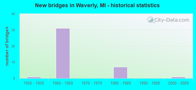
- New bridges - historical statistics
- 11950-1959
- 311960-1969
- 71980-1989
- 12000-2009
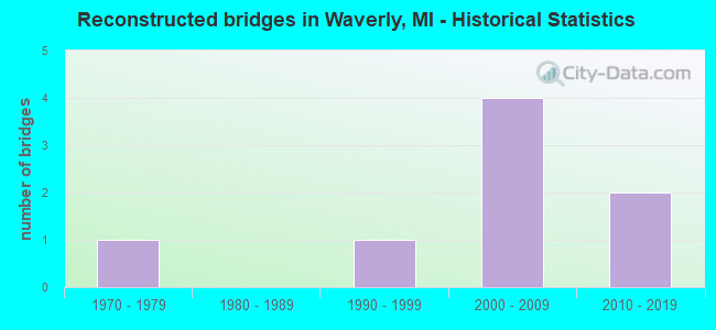
- Reconstructed bridges - Historical Statistics
- 11970-1979
- 01980-1989
- 11990-1999
- 42000-2009
- 22010-2019
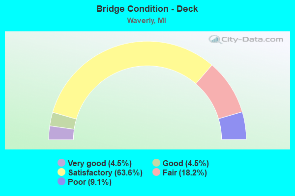
- Bridge Condition - Deck
- 4.5%Very good
- 4.5%Good
- 63.6%Satisfactory
- 18.2%Fair
- 9.1%Poor
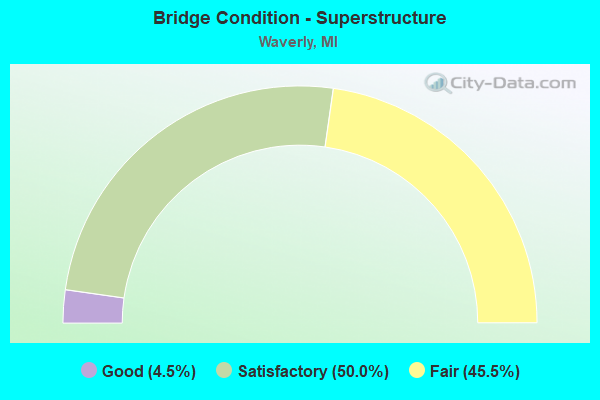
- Bridge Condition - Superstructure
- 4.5%Good
- 50.0%Satisfactory
- 45.5%Fair

- Bridge Condition - Substructure
- 27.3%Good
- 59.1%Satisfactory
- 13.6%Fair
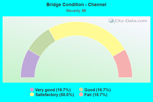
- Bridge Condition - Channel
- 16.7%Very good
- 16.7%Good
- 50.0%Satisfactory
- 16.7%Fair
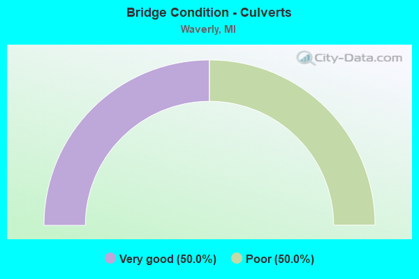
- Bridge Condition - Culverts
- 50.0%Very good
- 50.0%Poor
Find on map >> Show street view
Structure Number: 1785, Location: 0.3 MI N OF EATON CO LINE (Lat: 42.774189, Lng: -84.669722), Route carried "on" structure: Interstate 96, Year Built: 1962, Year Reconstructed: 2006, Status: Open, Structure Length: 4.36m (14.30ft), Average Daily Traffic: 18,210 (year 2007), Truck Traffic: 18%, Average Future Daily Traffic: 16,114 (year 2018), Design Load: HS 20+Mod, Features Intersected: CSX RR
Minimum Vertical Clearance: 30.48m (100.00ft), Kilometerpoint: 15.859, Lanes on structure: 2, Base Highway Network: Yes (Inventory Route: 20, Subroute: 1), Owner: State Highway Agency, Approaching Roadway Width: 11.9m (39.0ft), Skew: 1 degrees, Material/Design: Prestressed concrete, Design/Construction: Stringer/Multi-beam, Number Of Spans In Main Unit: 3, Length of Maximum Span: 15.0m (49.2ft), Curb-To-Curb Width: 11.9m (39.0ft), Out-to-Out Width: 13.3m (43.6ft)
Condition: Deck: Satisfactory, Superstructure: Satisfactory, Substructure: Satisfactory, Operating Rating: 57.3 metric tons, Method Used To Determine Operating Rating: Load Factor (LF) rating reported by rating factor (RF) method using MS18 loading, Inventory Rating: 34.3 metric tons, Method Used To Determine Inventory Rating: Load Factor (LF) rating reported by rating factor (RF) method using MS18 loading, Structural Evaluation: Equal to present minimum criteria, Deck Geometry: Equal to present minimum criteria, Approach Roadway Alignment: Equal to present desirable criteria, Designated Inspection Frequency: Every 24 months, Inspection Date: April 2020, Deck Structure Type: Concrete Cast-file-Place, Wearing Surface/Protective System: Wearing Surface: Latex Concrete
Find on map >> Show street view
Structure Number: 1786, Location: 0.3 MI N OF EATON CO LINE (Lat: 42.774150, Lng: -84.669361), Route carried "on" structure: Interstate 96, Year Built: 1962, Year Reconstructed: 2005, Status: Open, Structure Length: 4.36m (14.30ft), Average Daily Traffic: 18,210 (year 2007), Truck Traffic: 18%, Average Future Daily Traffic: 16,114 (year 2018), Design Load: HS 20+Mod, Features Intersected: CSX RR
Minimum Vertical Clearance: 30.48m (100.00ft), Kilometerpoint: 15.909, Lanes on structure: 5, Base Highway Network: Yes (Inventory Route: 20, Subroute: 2), Owner: State Highway Agency, Approaching Roadway Width: 23.5m (77.1ft), Skew: 1 degrees, Material/Design: Prestressed concrete, Design/Construction: Stringer/Multi-beam, Number Of Spans In Main Unit: 3, Length of Maximum Span: 15.0m (49.2ft), Curb-To-Curb Width: 26.0m (85.3ft), Out-to-Out Width: 27.2m (89.2ft)
Condition: Deck: Fair, Superstructure: Satisfactory, Substructure: Satisfactory, Operating Rating: 54.1 metric tons, Method Used To Determine Operating Rating: Load Factor (LF) rating reported by rating factor (RF) method using MS18 loading, Inventory Rating: 32.4 metric tons, Method Used To Determine Inventory Rating: Load Factor (LF) rating reported by rating factor (RF) method using MS18 loading, Structural Evaluation: Equal to present minimum criteria, Deck Geometry: Superior to present desirable criteria, Approach Roadway Alignment: Equal to present desirable criteria, Designated Inspection Frequency: Every 24 months, Inspection Date: April 2020, Deck Structure Type: Concrete Cast-file-Place, Wearing Surface/Protective System: Wearing Surface: Latex Concrete
Find on map >> Show street view
Structure Number: 1863, Location: 6.5 MI NW OF LANSING (Lat: 42.774347, Lng: -84.672067), Route carried "on" structure: Interstate 69, Year Built: 1981, Status: Open, Structure Length: 4.29m (14.07ft), Average Daily Traffic: 10,507 (year 2007), Truck Traffic: 16%, Average Future Daily Traffic: 23,290 (year 2018), Design Load: HS 25 or greater, Features Intersected: CSX RR
Minimum Vertical Clearance: 30.48m (100.00ft), Kilometerpoint: 0.510, Lanes on structure: 2, Base Highway Network: Yes (Inventory Route: 36, Subroute: 2), Owner: State Highway Agency, Approaching Roadway Width: 14.0m (45.9ft), Material/Design: Prestressed concrete, Design/Construction: Stringer/Multi-beam, Number Of Spans In Main Unit: 3, Length of Maximum Span: 14.3m (46.9ft), Curb-To-Curb Width: 13.4m (44.0ft), Out-to-Out Width: 13.9m (45.6ft)
Condition: Deck: Satisfactory, Superstructure: Satisfactory, Substructure: Satisfactory, Operating Rating: 66.4 metric tons, Method Used To Determine Operating Rating: Load Factor (LF) rating reported by rating factor (RF) method using MS18 loading, Inventory Rating: 39.9 metric tons, Method Used To Determine Inventory Rating: Load Factor (LF) rating reported by rating factor (RF) method using MS18 loading, Structural Evaluation: Equal to present minimum criteria, Deck Geometry: Superior to present desirable criteria, Approach Roadway Alignment: Better than present minimum criteria, Designated Inspection Frequency: Every 24 months, Inspection Date: April 2020, Deck Structure Type: Concrete Cast-file-Place, Wearing Surface/Protective System: Wearing Surface: Epoxy Overlay, Deck Protection: Epoxy Coated Reinforcing
Find on map >> Show street view
Structure Number: 2289, Location: 3.5 MI W OF LANSING (Lat: 42.716397, Lng: -84.668947), Route carried "on" structure: Ramp Interstate 496, Year Built: 1969, Status: Open, Structure Length: 6.85m (22.47ft), Average Daily Traffic: 17,512 (year 2018), Truck Traffic: 8%, Average Future Daily Traffic: 19,550 (year 2040), Design Load: HS 20+Mod, Features Intersected: I-96
Minimum Vertical Clearance: 30.48m (100.00ft), Kilometerpoint: 1.477, Lanes on structure: 2, Lanes under structure: 6, Owner: State Highway Agency, Approaching Roadway Width: 11.8m (38.7ft), Skew: 1 degrees, Material/Design: Steel, Design/Construction: Stringer/Multi-beam, Number Of Spans In Main Unit: 4, Length of Maximum Span: 23.6m (77.4ft), Curb-To-Curb Width: 9.6m (31.5ft), Out-to-Out Width: 10.6m (34.8ft)
Condition: Deck: Satisfactory, Superstructure: Fair, Substructure: Satisfactory, Operating Rating: 60.3 metric tons, Method Used To Determine Operating Rating: Load Factor (LF) rating reported by rating factor (RF) method using MS18 loading, Inventory Rating: 36.0 metric tons, Method Used To Determine Inventory Rating: Load Factor (LF) rating reported by rating factor (RF) method using MS18 loading, Structural Evaluation: Somewhat better than minimum adequacy, Deck Geometry: Somewhat better than minimum adequacy, Underclear: Somewhat better than minimum adequacy, Approach Roadway Alignment: Equal to present desirable criteria, Designated Inspection Frequency: Every 24 months, Inspection Date: October 2021, Bridge Improvement Cost: $190,000, Deck Structure Type: Concrete Cast-file-Place, Wearing Surface/Protective System: Wearing Surface: Integral Concrete, Deck Protection: Epoxy Coated Reinforcing
Find on map >> Show street view
Structure Number: 229, Location: 3.5 MI W OF LANSING (Lat: 42.719839, Lng: -84.668792), Route carried "on" structure: Interstate 496, Year Built: 1969, Year Reconstructed: 2001, Status: Open, Structure Length: 7.12m (23.36ft), Average Daily Traffic: 17,512 (year 2018), Truck Traffic: 8%, Average Future Daily Traffic: 19,550 (year 2040), Design Load: HS 20+Mod, Features Intersected: I-96
Minimum Vertical Clearance: 30.48m (100.00ft), Kilometerpoint: 0.000, Lanes on structure: 2, Lanes under structure: 6, Base Highway Network: Yes (Inventory Route: 56, Subroute: 4), Owner: State Highway Agency, Approaching Roadway Width: 12.5m (41.0ft), Material/Design: Steel, Design/Construction: Stringer/Multi-beam, Number Of Spans In Main Unit: 4, Length of Maximum Span: 24.7m (81.0ft), Curb-To-Curb Width: 12.0m (39.4ft), Out-to-Out Width: 13.0m (42.7ft)
Condition: Deck: Satisfactory, Superstructure: Fair, Substructure: Satisfactory, Operating Rating: 86.2 metric tons, Method Used To Determine Operating Rating: Load Factor (LF) rating reported by rating factor (RF) method using MS18 loading, Inventory Rating: 51.5 metric tons, Method Used To Determine Inventory Rating: Load Factor (LF) rating reported by rating factor (RF) method using MS18 loading, Structural Evaluation: Somewhat better than minimum adequacy, Deck Geometry: Equal to present minimum criteria, Underclear: Somewhat better than minimum adequacy, Approach Roadway Alignment: Equal to present desirable criteria, Designated Inspection Frequency: Every 24 months, Inspection Date: October 2021, Deck Structure Type: Concrete Cast-file-Place, Wearing Surface/Protective System: Wearing Surface: Epoxy Overlay, Deck Protection: Epoxy Coated Reinforcing
Find on map >> Show street view
Structure Number: 2291, Location: 3.2 MI W OF LANSING (Lat: 42.718172, Lng: -84.662022), Route carried "on" structure: County highway , Year Built: 1969, Status: Open, Structure Length: 4.51m (14.80ft), Average Daily Traffic: 7,500 (year 1995), Truck Traffic: 14%, Average Future Daily Traffic: 8,144 (year 2015), Design Load: H 20, Features Intersected: I-496 EB, Facility Carried by Structure: CANAL RD
Minimum Vertical Clearance: 30.48m (100.00ft), Kilometerpoint: 20.026, Lanes on structure: 2, Lanes under structure: 3, Owner: State Highway Agency, Approaching Roadway Width: 11.8m (38.7ft), Skew: 4 degrees, Material/Design: Steel, Design/Construction: Stringer/Multi-beam, Number Of Spans In Main Unit: 3, Length of Maximum Span: 24.5m (80.4ft), Curb-To-Curb Width: 9.9m (32.5ft), Out-to-Out Width: 11.1m (36.4ft)
Condition: Deck: Satisfactory, Superstructure: Satisfactory, Substructure: Satisfactory, Operating Rating: 71.0 metric tons, Method Used To Determine Operating Rating: Load Factor (LF) rating reported by rating factor (RF) method using MS18 loading, Inventory Rating: 42.4 metric tons, Method Used To Determine Inventory Rating: Load Factor (LF) rating reported by rating factor (RF) method using MS18 loading, Structural Evaluation: Equal to present minimum criteria, Deck Geometry: Meets minimum limits, Underclear: High priority of corrective action, Approach Roadway Alignment: Equal to present desirable criteria, Designated Inspection Frequency: Every 24 months, Inspection Date: October 2021, Deck Structure Type: Concrete Cast-file-Place, Wearing Surface/Protective System: Wearing Surface: Epoxy Overlay
Find on map >> Show street view
Structure Number: 2292, Location: 3.2 MI W OF LANSING (Lat: 42.720147, Lng: -84.662025), Route carried "on" structure: County highway , Year Built: 1969, Status: Open, Structure Length: 10.74m (35.24ft), Average Daily Traffic: 3,010 (year 2005), Truck Traffic: 3%, Average Future Daily Traffic: 5,000 (year 2015), Design Load: H 20, Features Intersected: I-496, Facility Carried by Structure: CANAL RD
Minimum Vertical Clearance: 30.48m (100.00ft), Kilometerpoint: 20.211, Lanes on structure: 2, Lanes under structure: 4, Owner: State Highway Agency, Approaching Roadway Width: 12.5m (41.0ft), Material/Design: Steel, Design/Construction: Stringer/Multi-beam, Number Of Spans In Main Unit: 5, Length of Maximum Span: 27.4m (89.9ft), Curb-To-Curb Width: 9.9m (32.5ft), Out-to-Out Width: 11.1m (36.4ft)
Condition: Deck: Fair, Superstructure: Fair, Substructure: Good, Operating Rating: 70.3 metric tons, Method Used To Determine Operating Rating: Load Factor (LF) rating reported by rating factor (RF) method using MS18 loading, Inventory Rating: 42.1 metric tons, Method Used To Determine Inventory Rating: Load Factor (LF) rating reported by rating factor (RF) method using MS18 loading, Structural Evaluation: Somewhat better than minimum adequacy, Deck Geometry: Meets minimum limits, Underclear: Meets minimum limits, Approach Roadway Alignment: Equal to present desirable criteria, Designated Inspection Frequency: Every 24 months, Other Special Inspection Frequency: Every 28 months, Inspection Date: October 2021, Other Special Inspection Date: June 2020, Deck Structure Type: Concrete Cast-file-Place, Wearing Surface/Protective System: Wearing Surface: Epoxy Overlay
Find on map >> Show street view
Structure Number: 2293, Location: 3.0 MI W OF LANSING (Lat: 42.719600, Lng: -84.642425), Route carried "on" structure: County highway 2003, Year Built: 1969, Status: Open, Structure Length: 5.85m (19.19ft), Average Daily Traffic: 2,000 (year 1991), Truck Traffic: 1%, Average Future Daily Traffic: 1,200 (year 2011), Design Load: H 20, Features Intersected: I-496, Facility Carried by Structure: CREYTS RD NB
Minimum Vertical Clearance: 30.48m (100.00ft), Kilometerpoint: 8.041, Lanes on structure: 2, Lanes under structure: 6, Owner: State Highway Agency, Approaching Roadway Width: 9.9m (32.5ft), Material/Design: Steel continuous, Design/Construction: Girder and Floorbeam System, Number Of Spans In Main Unit: 2, Length of Maximum Span: 29.2m (95.8ft), Curb or Sidewalk Widths: Left: 0.6m (2.0ft), Right: 0.2m (0.7ft), Curb-To-Curb Width: 9.8m (32.2ft), Out-to-Out Width: 11.1m (36.4ft)
Condition: Deck: Very good, Superstructure: Satisfactory, Substructure: Satisfactory, Operating Rating: 49.9 metric tons, Method Used To Determine Operating Rating: Load Factor (LF) rating reported by rating factor (RF) method using MS18 loading, Inventory Rating: 24.3 metric tons, Method Used To Determine Inventory Rating: Load Factor (LF) rating reported by rating factor (RF) method using MS18 loading, Structural Evaluation: Equal to present minimum criteria, Deck Geometry: Meets minimum limits, Underclear: High priority of corrective action, Approach Roadway Alignment: Equal to present desirable criteria, Designated Inspection Frequency: Every 24 months, Critical Feature Inspection Frequency: Every 15 months, Inspection Date: October 2021, Critical Feature Inspection Date: October 2021, Deck Structure Type: Steel plate, Wearing Surface/Protective System: Wearing Surface: Bituminous
Find on map >> Show street view
Structure Number: 2294, Location: 2.0 MI W OF LANSING (Lat: 42.719914, Lng: -84.622772), Route carried "on" structure: County highway , Year Built: 1969, Status: Open, Structure Length: 5.85m (19.19ft), Average Daily Traffic: 1,000 (year 1988), Truck Traffic: 3%, Average Future Daily Traffic: 1,150 (year 2008), Design Load: H 20, Features Intersected: I-496, Facility Carried by Structure: SNOW RD
Minimum Vertical Clearance: 30.48m (100.00ft), Kilometerpoint: 1.788, Lanes on structure: 2, Lanes under structure: 4, Owner: State Highway Agency, Approaching Roadway Width: 12.5m (41.0ft), Material/Design: Steel continuous, Design/Construction: Stringer/Multi-beam, Number Of Spans In Main Unit: 2, Length of Maximum Span: 29.3m (96.1ft), Curb-To-Curb Width: 12.0m (39.4ft), Out-to-Out Width: 12.8m (42.0ft)
Condition: Deck: Fair, Superstructure: Satisfactory, Substructure: Satisfactory, Operating Rating: 68.0 metric tons, Method Used To Determine Operating Rating: Load Factor (LF) rating reported by rating factor (RF) method using MS18 loading, Inventory Rating: 40.8 metric tons, Method Used To Determine Inventory Rating: Load Factor (LF) rating reported by rating factor (RF) method using MS18 loading, Structural Evaluation: Equal to present minimum criteria, Deck Geometry: Better than present minimum criteria, Underclear: High priority of corrective action, Approach Roadway Alignment: Equal to present desirable criteria, Designated Inspection Frequency: Every 24 months, Inspection Date: October 2021, Bridge Improvement Cost: $29,000, Deck Structure Type: Concrete Cast-file-Place, Wearing Surface/Protective System: Wearing Surface: Latex Concrete
Find on map >> Show street view
Structure Number: 2295, Location: AT EATON-INGHAM CO LINE (Lat: 42.721864, Lng: -84.603014), Route carried "on" structure: Interstate 496, Year Built: 1969, Status: Open, Structure Length: 5.17m (16.96ft), Average Daily Traffic: 22,213 (year 2018), Truck Traffic: 5%, Average Future Daily Traffic: 24,788 (year 2038), Design Load: HS 20, Features Intersected: WAVERLY RD
Minimum Vertical Clearance: 30.48m (100.00ft), Kilometerpoint: 5.429, Lanes on structure: 2, Lanes under structure: 5, Base Highway Network: Yes (Inventory Route: 56, Subroute: 4), Owner: State Highway Agency, Approaching Roadway Width: 15.5m (50.9ft), Material/Design: Steel, Design/Construction: Stringer/Multi-beam, Number Of Spans In Main Unit: 3, Length of Maximum Span: 32.3m (106.0ft), Curb-To-Curb Width: 14.1m (46.3ft), Out-to-Out Width: 15.1m (49.5ft)
Condition: Deck: Satisfactory, Superstructure: Satisfactory, Substructure: Good, Operating Rating: 73.9 metric tons, Method Used To Determine Operating Rating: Load Factor (LF) rating reported by rating factor (RF) method using MS18 loading, Inventory Rating: 44.1 metric tons, Method Used To Determine Inventory Rating: Load Factor (LF) rating reported by rating factor (RF) method using MS18 loading, Structural Evaluation: Equal to present minimum criteria, Deck Geometry: Superior to present desirable criteria, Underclear: Meets minimum limits, Approach Roadway Alignment: Equal to present desirable criteria, Length Of Structure Improvement: 5.18m (16.99ft), Designated Inspection Frequency: Every 24 months, Inspection Date: October 2021, Bridge Improvement Cost: $429,000, Roadway Improvement Cost: $40,000, Total Project Cost: $472,000, Deck Structure Type: Concrete Cast-file-Place, Wearing Surface/Protective System: Wearing Surface: Epoxy Overlay
Find on map >> Show street view
Structure Number: 2296, Location: AT EATON-INGHAM CO LINE (Lat: 42.721578, Lng: -84.603033), Route carried "on" structure: Interstate 496, Year Built: 1969, Status: Open, Structure Length: 5.17m (16.96ft), Average Daily Traffic: 22,213 (year 2018), Truck Traffic: 5%, Average Future Daily Traffic: 24,788 (year 2038), Design Load: HS 20, Features Intersected: WAVERLY RD
Minimum Vertical Clearance: 30.48m (100.00ft), Kilometerpoint: 4.444, Lanes on structure: 3, Lanes under structure: 5, Base Highway Network: Yes (Inventory Route: 56, Subroute: 8), Owner: State Highway Agency, Approaching Roadway Width: 15.5m (50.9ft), Material/Design: Steel, Design/Construction: Stringer/Multi-beam, Number Of Spans In Main Unit: 3, Length of Maximum Span: 32.3m (106.0ft), Curb-To-Curb Width: 14.1m (46.3ft), Out-to-Out Width: 15.1m (49.5ft)
Condition: Deck: Satisfactory, Superstructure: Satisfactory, Substructure: Good, Operating Rating: 73.9 metric tons, Method Used To Determine Operating Rating: Load Factor (LF) rating reported by rating factor (RF) method using MS18 loading, Inventory Rating: 44.1 metric tons, Method Used To Determine Inventory Rating: Load Factor (LF) rating reported by rating factor (RF) method using MS18 loading, Structural Evaluation: Equal to present minimum criteria, Deck Geometry: Meets minimum limits, Underclear: Meets minimum limits, Approach Roadway Alignment: Equal to present desirable criteria, Length Of Structure Improvement: 5.18m (16.99ft), Designated Inspection Frequency: Every 24 months, Inspection Date: October 2021, Bridge Improvement Cost: $429,000, Roadway Improvement Cost: $40,000, Total Project Cost: $472,000, Deck Structure Type: Concrete Cast-file-Place, Wearing Surface/Protective System: Wearing Surface: Epoxy Overlay
Find on map >> Show street view
Structure Number: 2297, Location: AT I-96/I-496 JCT (Lat: 42.719358, Lng: -84.672422), Route carried "on" structure: Ramp Interstate 496, Year Built: 1989, Status: Open, Structure Length: 4.51m (14.80ft), Average Daily Traffic: 7,500 (year 1995), Truck Traffic: 14%, Average Future Daily Traffic: 8,164 (year 2015), Design Load: HS 20, Features Intersected: I-96EB TO I-496EB RMP C
Minimum Vertical Clearance: 30.48m (100.00ft), Kilometerpoint: 0.282, Lanes on structure: 2, Lanes under structure: 2, Owner: State Highway Agency, Approaching Roadway Width: 15.5m (50.9ft), Skew: 2 degrees, Material/Design: Steel, Design/Construction: Stringer/Multi-beam, Number Of Spans In Main Unit: 1, Length of Maximum Span: 45.1m (148.0ft), Curb-To-Curb Width: 14.6m (47.9ft), Out-to-Out Width: 15.6m (51.2ft)
Condition: Deck: Good, Superstructure: Satisfactory, Substructure: Satisfactory, Operating Rating: 74.5 metric tons, Method Used To Determine Operating Rating: Load Factor (LF) rating reported by rating factor (RF) method using MS18 loading, Inventory Rating: 44.4 metric tons, Method Used To Determine Inventory Rating: Load Factor (LF) rating reported by rating factor (RF) method using MS18 loading, Structural Evaluation: Equal to present minimum criteria, Deck Geometry: Superior to present desirable criteria, Underclear: Meets minimum limits, Approach Roadway Alignment: Equal to present desirable criteria, Designated Inspection Frequency: Every 24 months, Inspection Date: October 2021, Deck Structure Type: Concrete Cast-file-Place, Wearing Surface/Protective System: Wearing Surface: Epoxy Overlay, Deck Protection: Epoxy Coated Reinforcing
Find on map >> Show street view
Structure Number: 2315, Location: 0.2 MI S OF CLINTON COL (Lat: 42.767214, Lng: -84.668683), Route carried "on" structure: Interstate 96, Year Built: 1962, Year Reconstructed: 2006, Status: Open, Structure Length: 8.18m (26.84ft), Average Daily Traffic: 27,100 (year 2007), Truck Traffic: 21%, Average Future Daily Traffic: 26,492 (year 2018), Design Load: HS 20+Mod, Features Intersected: GRAND RIVER
Minimum Vertical Clearance: 30.48m (100.00ft), Kilometerpoint: 0.241, Lanes on structure: 2, Base Highway Network: Yes (Inventory Route: 56, Subroute: 5), Owner: State Highway Agency, Approaching Roadway Width: 13.7m (44.9ft), Skew: 10 degrees, Material/Design: Steel, Design/Construction: Stringer/Multi-beam, Number Of Spans In Main Unit: 3, Length of Maximum Span: 28.7m (94.2ft), Curb-To-Curb Width: 13.7m (44.9ft), Out-to-Out Width: 15.4m (50.5ft)
Condition: Deck: Satisfactory, Superstructure: Fair, Substructure: Fair, Channel: Good, Operating Rating: 80.4 metric tons, Method Used To Determine Operating Rating: Load Factor (LF) rating reported by rating factor (RF) method using MS18 loading, Inventory Rating: 48.0 metric tons, Method Used To Determine Inventory Rating: Load Factor (LF) rating reported by rating factor (RF) method using MS18 loading, Structural Evaluation: Somewhat better than minimum adequacy, Deck Geometry: Superior to present desirable criteria, Waterway Adequacy: Better than present minimum criteria, Approach Roadway Alignment: Equal to present desirable criteria, Designated Inspection Frequency: Every 24 months, Underwater Inspection Frequency: Every 60 months, Other Special Inspection Frequency: Every 24 months, Inspection Date: July 2021, Underwater Inspection Date: July 2020, Other Special Inspection Date: April 2021, Deck Structure Type: Concrete Cast-file-Place, Wearing Surface/Protective System: Wearing Surface: Latex Concrete
Find on map >> Show street view
Structure Number: 2316, Location: 0.2 MI S OF CLINTON COL (Lat: 42.767242, Lng: -84.668386), Route carried "on" structure: Interstate 96, Year Built: 1962, Year Reconstructed: 2006, Status: Open, Structure Length: 8.18m (26.84ft), Average Daily Traffic: 27,100 (year 2007), Truck Traffic: 21%, Average Future Daily Traffic: 26,492 (year 2018), Design Load: HS 20+Mod, Features Intersected: GRAND RIVER
Minimum Vertical Clearance: 30.48m (100.00ft), Kilometerpoint: 0.237, Lanes on structure: 3, Base Highway Network: Yes (Inventory Route: 56, Subroute: 6), Owner: State Highway Agency, Approaching Roadway Width: 18.3m (60.0ft), Skew: 10 degrees, Material/Design: Steel, Design/Construction: Stringer/Multi-beam, Number Of Spans In Main Unit: 3, Length of Maximum Span: 28.7m (94.2ft), Curb-To-Curb Width: 18.3m (60.0ft), Out-to-Out Width: 19.5m (64.0ft)
Condition: Deck: Satisfactory, Superstructure: Fair, Substructure: Fair, Channel: Satisfactory, Operating Rating: 82.9 metric tons, Method Used To Determine Operating Rating: Load Factor (LF) rating reported by rating factor (RF) method using MS18 loading, Inventory Rating: 49.6 metric tons, Method Used To Determine Inventory Rating: Load Factor (LF) rating reported by rating factor (RF) method using MS18 loading, Structural Evaluation: Somewhat better than minimum adequacy, Deck Geometry: Better than present minimum criteria, Waterway Adequacy: Better than present minimum criteria, Approach Roadway Alignment: Equal to present desirable criteria, Designated Inspection Frequency: Every 24 months, Underwater Inspection Frequency: Every 60 months, Other Special Inspection Frequency: Every 24 months, Inspection Date: July 2021, Underwater Inspection Date: July 2020, Other Special Inspection Date: April 2021, Deck Structure Type: Concrete Cast-file-Place, Wearing Surface/Protective System: Wearing Surface: Latex Concrete, Deck Protection: Epoxy Coated Reinforcing
Find on map >> Show street view
Structure Number: 2317, Location: 6 MI NW OF LANSING (Lat: 42.767183, Lng: -84.669061), Route carried "on" structure: Ramp Interstate 96, Year Built: 1981, Status: Open, Structure Length: 8.35m (27.40ft), Average Daily Traffic: 10,507 (year 2007), Truck Traffic: 16%, Average Future Daily Traffic: 17,691 (year 2018), Design Load: HS 25 or greater, Features Intersected: GRAND RIVER
Minimum Vertical Clearance: 30.48m (100.00ft), Kilometerpoint: 0.367, Lanes on structure: 2, Owner: State Highway Agency, Approaching Roadway Width: 12.8m (42.0ft), Skew: 1 degrees, Material/Design: Steel, Design/Construction: Stringer/Multi-beam, Number Of Spans In Main Unit: 3, Length of Maximum Span: 29.2m (95.8ft), Curb-To-Curb Width: 13.3m (43.6ft), Out-to-Out Width: 13.9m (45.6ft)
Condition: Deck: Satisfactory, Superstructure: Fair, Substructure: Fair, Channel: Satisfactory, Operating Rating: 66.1 metric tons, Method Used To Determine Operating Rating: Load Factor (LF) rating reported by rating factor (RF) method using MS18 loading, Inventory Rating: 39.5 metric tons, Method Used To Determine Inventory Rating: Load Factor (LF) rating reported by rating factor (RF) method using MS18 loading, Structural Evaluation: Somewhat better than minimum adequacy, Deck Geometry: Superior to present desirable criteria, Waterway Adequacy: Equal to present desirable criteria, Approach Roadway Alignment: Equal to present desirable criteria, Designated Inspection Frequency: Every 24 months, Underwater Inspection Frequency: Every 60 months, Other Special Inspection Frequency: Every 24 months, Inspection Date: July 2021, Underwater Inspection Date: July 2020, Other Special Inspection Date: April 2021, Deck Structure Type: Concrete Cast-file-Place, Wearing Surface/Protective System: Wearing Surface: Epoxy Overlay, Deck Protection: Epoxy Coated Reinforcing
Find on map >> Show street view
Structure Number: 2322, Location: 1.0 MI S OF CLINTON COL (Lat: 42.755514, Lng: -84.667400), Route carried "on" structure: County highway , Year Built: 1961, Status: Open, Structure Length: 6.55m (21.49ft), Average Daily Traffic: 1,500 (year 1988), Truck Traffic: 3%, Average Future Daily Traffic: 1,725 (year 2008), Design Load: H 15, Features Intersected: I-96, Facility Carried by Structure: WILLOW HWY
Minimum Vertical Clearance: 30.48m (100.00ft), Kilometerpoint: 6.162, Lanes on structure: 2, Lanes under structure: 6, Owner: State Highway Agency, Approaching Roadway Width: 11.5m (37.7ft), Material/Design: Prestressed concrete, Design/Construction: Stringer/Multi-beam, Number Of Spans In Main Unit: 4, Length of Maximum Span: 21.3m (69.9ft), Curb-To-Curb Width: 8.3m (27.2ft), Out-to-Out Width: 9.3m (30.5ft)
Condition: Deck: Fair, Superstructure: Fair, Substructure: Satisfactory, Operating Rating: 55.1 metric tons, Method Used To Determine Operating Rating: Load Factor (LF) rating reported by rating factor (RF) method using MS18 loading, Inventory Rating: 33.0 metric tons, Method Used To Determine Inventory Rating: Load Factor (LF) rating reported by rating factor (RF) method using MS18 loading, Structural Evaluation: Somewhat better than minimum adequacy, Deck Geometry: Meets minimum limits, Underclear: High priority of corrective action, Approach Roadway Alignment: Equal to present desirable criteria, Designated Inspection Frequency: Every 24 months, Inspection Date: July 2021, Deck Structure Type: Concrete Cast-file-Place, Wearing Surface/Protective System: Wearing Surface: Epoxy Overlay
Find on map >> Show street view
Structure Number: 2323, Location: @ M-43 (Lat: 42.741061, Lng: -84.668286), Route carried "on" structure: Interstate 96, Year Built: 1962, Year Reconstructed: 2010, Status: Open, Structure Length: 4.93m (16.17ft), Average Daily Traffic: 31,250 (year 2007), Average Future Daily Traffic: 33,250 (year 2031), Design Load: HS 20+Mod, Features Intersected: M-43
Minimum Vertical Clearance: 30.48m (100.00ft), Kilometerpoint: 3.211, Lanes on structure: 4, Lanes under structure: 6, Base Highway Network: Yes (Inventory Route: 56, Subroute: 5), Owner: State Highway Agency, Approaching Roadway Width: 17.7m (58.1ft), Skew: 10 degrees, Material/Design: Steel, Design/Construction: Stringer/Multi-beam, Number Of Spans In Main Unit: 3, Length of Maximum Span: 27.6m (90.6ft), Curb-To-Curb Width: 21.9m (71.9ft), Out-to-Out Width: 23.0m (75.5ft)
Condition: Deck: Satisfactory, Superstructure: Fair, Substructure: Satisfactory, Operating Rating: 70.6 metric tons, Method Used To Determine Operating Rating: Load Factor (LF) rating reported by rating factor (RF) method using MS18 loading, Inventory Rating: 42.4 metric tons, Method Used To Determine Inventory Rating: Load Factor (LF) rating reported by rating factor (RF) method using MS18 loading, Structural Evaluation: Somewhat better than minimum adequacy, Deck Geometry: Better than present minimum criteria, Underclear: High priority of corrective action, Approach Roadway Alignment: Equal to present desirable criteria, Designated Inspection Frequency: Every 24 months, Inspection Date: July 2021, Deck Structure Type: Concrete Cast-file-Place, Wearing Surface/Protective System: Wearing Surface: Latex Concrete
Find on map >> Show street view
Structure Number: 2324, Location: @ M-43 (Lat: 42.741061, Lng: -84.667969), Route carried "on" structure: Interstate 96, Year Built: 1962, Year Reconstructed: 2010, Status: Open, Structure Length: 4.93m (16.17ft), Average Daily Traffic: 31,250 (year 2007), Average Future Daily Traffic: 33,250 (year 2031), Design Load: HS 20+Mod, Features Intersected: M-43
Minimum Vertical Clearance: 30.48m (100.00ft), Kilometerpoint: 3.211, Lanes on structure: 4, Lanes under structure: 6, Base Highway Network: Yes (Inventory Route: 56, Subroute: 6), Owner: State Highway Agency, Approaching Roadway Width: 17.7m (58.1ft), Skew: 10 degrees, Material/Design: Steel, Design/Construction: Stringer/Multi-beam, Number Of Spans In Main Unit: 3, Length of Maximum Span: 27.6m (90.6ft), Curb-To-Curb Width: 21.9m (71.9ft), Out-to-Out Width: 23.0m (75.5ft)
Condition: Deck: Satisfactory, Superstructure: Fair, Substructure: Satisfactory, Operating Rating: 70.6 metric tons, Method Used To Determine Operating Rating: Load Factor (LF) rating reported by rating factor (RF) method using MS18 loading, Inventory Rating: 42.4 metric tons, Method Used To Determine Inventory Rating: Load Factor (LF) rating reported by rating factor (RF) method using MS18 loading, Structural Evaluation: Somewhat better than minimum adequacy, Deck Geometry: Better than present minimum criteria, Underclear: High priority of corrective action, Approach Roadway Alignment: Equal to present desirable criteria, Designated Inspection Frequency: Every 24 months, Inspection Date: July 2021, Deck Structure Type: Concrete Cast-file-Place, Wearing Surface/Protective System: Wearing Surface: Latex Concrete
Find on map >> Show street view
Structure Number: 2325, Location: 1.0 MI S OF M-43 (Lat: 42.726542, Lng: -84.668311), Route carried "on" structure: County highway 2003, Year Built: 1962, Status: Open, Structure Length: 9.90m (32.48ft), Average Daily Traffic: 2,850 (year 2018), Truck Traffic: 4%, Average Future Daily Traffic: 3,785 (year 2040), Design Load: H 15, Features Intersected: I-96, Facility Carried by Structure: ST JOSEPH HWY
Minimum Vertical Clearance: 30.48m (100.00ft), Kilometerpoint: 31.795, Lanes on structure: 2, Lanes under structure: 9, Owner: State Highway Agency, Approaching Roadway Width: 11.5m (37.7ft), Material/Design: Prestressed concrete, Design/Construction: Stringer/Multi-beam, Number Of Spans In Main Unit: 6, Length of Maximum Span: 21.6m (70.9ft), Curb or Sidewalk Widths: Left: 0.7m (2.3ft), Right: 0.7m (2.3ft), Curb-To-Curb Width: 7.9m (25.9ft), Out-to-Out Width: 10.0m (32.8ft)
Condition: Deck: Poor, Superstructure: Satisfactory, Substructure: Good, Operating Rating: 48.0 metric tons, Method Used To Determine Operating Rating: Load Factor (LF) rating reported by rating factor (RF) method using MS18 loading, Inventory Rating: 28.5 metric tons, Method Used To Determine Inventory Rating: Load Factor (LF) rating reported by rating factor (RF) method using MS18 loading, Structural Evaluation: Equal to present minimum criteria, Deck Geometry: High priority of corrective action, Underclear: High priority of corrective action, Approach Roadway Alignment: Equal to present desirable criteria, Designated Inspection Frequency: Every 24 months, Inspection Date: July 2021, Deck Structure Type: Concrete Cast-file-Place, Wearing Surface/Protective System: Wearing Surface: Monolithic Concrete
Find on map >> Show street view
Structure Number: 2332, Location: CLINTON/EATON CO LINE (Lat: 42.769944, Lng: -84.669300), Route carried "on" structure: County highway 19, Year Built: 1961, Year Reconstructed: 1981, Status: Open, Structure Length: 6.61m (21.69ft), Average Daily Traffic: 1,400 (year 1988), Average Future Daily Traffic: 1,610 (year 2008), Design Load: H 15, Features Intersected: I-69 NB & I-96, Facility Carried by Structure: EATON HWY
Minimum Vertical Clearance: 30.48m (100.00ft), Kilometerpoint: 5.644, Lanes on structure: 2, Lanes under structure: 5, Owner: State Highway Agency, Approaching Roadway Width: 11.5m (37.7ft), Material/Design: Prestressed concrete, Design/Construction: Stringer/Multi-beam, Number Of Spans In Main Unit: 4, Length of Maximum Span: 21.5m (70.5ft), Curb-To-Curb Width: 11.0m (36.1ft), Out-to-Out Width: 12.2m (40.0ft)
Condition: Deck: Satisfactory, Superstructure: Satisfactory, Substructure: Good, Operating Rating: 63.5 metric tons, Method Used To Determine Operating Rating: Load Factor (LF) rating reported by rating factor (RF) method using MS18 loading, Inventory Rating: 38.2 metric tons, Method Used To Determine Inventory Rating: Load Factor (LF) rating reported by rating factor (RF) method using MS18 loading, Structural Evaluation: Equal to present minimum criteria, Deck Geometry: Equal to present minimum criteria, Underclear: Meets minimum limits, Approach Roadway Alignment: Equal to present desirable criteria, Designated Inspection Frequency: Every 24 months, Inspection Date: July 2021, Deck Structure Type: Concrete Cast-file-Place, Wearing Surface/Protective System: Wearing Surface: Epoxy Overlay, Deck Protection: Epoxy Coated Reinforcing
Find on map >> Show street view
Structure Number: 2333, Location: CLINTON/EATON CO LINE (Lat: 42.769944, Lng: -84.670917), Route carried "on" structure: County highway , Year Built: 1981, Status: Open, Structure Length: 5.54m (18.18ft), Average Daily Traffic: 1,400 (year 1988), Average Future Daily Traffic: 1,610 (year 2008), Design Load: HS 20, Features Intersected: I-69 TO I-96 EB, Facility Carried by Structure: EATON HWY
Minimum Vertical Clearance: 30.48m (100.00ft), Kilometerpoint: 5.766, Lanes on structure: 2, Lanes under structure: 2, Owner: State Highway Agency, Approaching Roadway Width: 11.5m (37.7ft), Skew: 2 degrees, Material/Design: Steel, Design/Construction: Stringer/Multi-beam, Number Of Spans In Main Unit: 3, Length of Maximum Span: 30.6m (100.4ft), Curb-To-Curb Width: 11.0m (36.1ft), Out-to-Out Width: 12.2m (40.0ft)
Condition: Deck: Satisfactory, Superstructure: Good, Substructure: Good, Operating Rating: 83.6 metric tons, Method Used To Determine Operating Rating: Allowable Stress (AS), Inventory Rating: 32.7 metric tons, Method Used To Determine Inventory Rating: Allowable Stress (AS), Structural Evaluation: Better than present minimum criteria, Deck Geometry: Equal to present minimum criteria, Underclear: Somewhat better than minimum adequacy, Approach Roadway Alignment: Equal to present desirable criteria, Designated Inspection Frequency: Every 24 months, Inspection Date: July 2021, Deck Structure Type: Concrete Cast-file-Place, Wearing Surface/Protective System: Wearing Surface: Epoxy Overlay, Deck Protection: Epoxy Coated Reinforcing
Find on map >> Show street view
Structure Number: 2362, Location: 8 MI N OF DIMONDALE (Lat: 42.761181, Lng: -84.648933), Route carried "on" structure: County highway 2003, Year Built: 1966, Status: Posted for load, Structure Length: 8.59m (28.18ft), Average Daily Traffic: 5,860 (year 2010), Average Future Daily Traffic: 7,000 (year 2015), Design Load: HS 20, Features Intersected: GRAND RIVER, Facility Carried by Structure: WEBSTER ROAD
Minimum Vertical Clearance: 30.48m (100.00ft), Kilometerpoint: 12.930, Lanes on structure: 2, Owner: County Highway Agency, Approaching Roadway Width: 9.1m (29.9ft), Material/Design: Prestressed concrete, Design/Construction: Box Beam or Girders - Multiple, Number Of Spans In Main Unit: 4, Length of Maximum Span: 21.3m (69.9ft), Curb or Sidewalk Widths: Left: 1.5m (4.9ft), Right: 1.5m (4.9ft), Curb-To-Curb Width: 9.1m (29.9ft), Out-to-Out Width: 13.1m (43.0ft)
Condition: Deck: Poor, Superstructure: Fair, Substructure: Satisfactory, Channel: Satisfactory, Operating Rating: 35.3 metric tons, Method Used To Determine Operating Rating: Load Factor (LF) rating reported by rating factor (RF) method using MS18 loading, Inventory Rating: 14.3 metric tons, Method Used To Determine Inventory Rating: Load Factor (LF) rating reported by rating factor (RF) method using MS18 loading, Structural Evaluation: High priority of corrective action, Deck Geometry: Meets minimum limits, Waterway Adequacy: Equal to present desirable criteria, Approach Roadway Alignment: Equal to present desirable criteria, Bridge Posting: Required (Relationship of Operating Rating to Maximum Legal Load: 30.0 - 39.9% below), Designated Inspection Frequency: Every 24 months, Inspection Date: August 2021, Bridge Improvement Cost: $50,000, Roadway Improvement Cost: $5,000, Total Project Cost: $55,000, Deck Structure Type: Concrete Precast Panels, Wearing Surface/Protective System: Wearing Surface: Bituminous
Find on map >> Show street view
Structure Number: 13404, Location: DELTA TWP SEC 3 & 10 (Lat: 42.755528, Lng: -84.652778), Route carried "on" structure: County highway , Year Built: 2004, Status: Open, Structure Length: 0.79m (2.59ft), Average Daily Traffic: 5,817 (year 2010), Average Future Daily Traffic: 6,400 (year 2030), Design Load: HS 20, Features Intersected: CARRIER CREEK, Facility Carried by Structure: WILLOW HWY
Minimum Vertical Clearance: 30+ m (98+ ft), Kilometerpoint: 7.392, Lanes on structure: 3, Owner: County Highway Agency, Approaching Roadway Width: 13.4m (44.0ft), Skew: 2 degrees, Material/Design: Concrete, Design/Construction: Culvert, Number Of Spans In Main Unit: 1, Length of Maximum Span: 7.3m (24.0ft), Curb-To-Curb Width: 13.4m (44.0ft), Out-to-Out Width: 45.1m (148.0ft)
Condition: Channel: Very good, Culverts: Very good, Operating Rating: 81.6 metric tons, Method Used To Determine Operating Rating: Field evaluation and documented engineering judgment, Inventory Rating: 49.0 metric tons, Method Used To Determine Inventory Rating: Field evaluation and documented engineering judgment, Structural Evaluation: Equal to present desirable criteria, Deck Geometry: Somewhat better than minimum adequacy, Waterway Adequacy: Equal to present desirable criteria, Approach Roadway Alignment: Equal to present desirable criteria, Designated Inspection Frequency: Every 24 months, Inspection Date: June 2021, Wearing Surface/Protective System: Wearing Surface: Bituminous
Find on map >> Show street view
Structure Number: 1399, Location: 0.4 MI W OF CREYTS ROAD (Lat: 42.741056, Lng: -84.649981), Route carried "on" structure: State highway 43, Year Built: 1956, Status: Open, Structure Length: 1.11m (3.64ft), Average Daily Traffic: 26,200 (year 2017), Average Future Daily Traffic: 100 (year 2037), Design Load: H 20, Features Intersected: CARRIER CREEK
Minimum Vertical Clearance: 30.48m (100.00ft), Kilometerpoint: 0.000, Lanes on structure: 5, Base Highway Network: Yes (Inventory Route: 56, Subroute: 3), Owner: State Highway Agency, Approaching Roadway Width: 19.5m (64.0ft), Material/Design: Steel, Design/Construction: Culvert, Number Of Spans In Main Unit: 3, Length of Maximum Span: 2.9m (9.5ft), Curb-To-Curb Width: 19.5m (64.0ft), Out-to-Out Width: 36.0m (118.1ft)
Condition: Channel: Fair, Culverts: Poor, Operating Rating: 97.2 metric tons, Method Used To Determine Operating Rating: Load Factor (LF) rating reported by rating factor (RF) method using MS18 loading, Inventory Rating: 97.2 metric tons, Method Used To Determine Inventory Rating: Load Factor (LF) rating reported by rating factor (RF) method using MS18 loading, Structural Evaluation: Meets minimum limits, Deck Geometry: Meets minimum limits, Waterway Adequacy: Equal to present desirable criteria, Approach Roadway Alignment: Equal to present desirable criteria, Designated Inspection Frequency: Every 12 months, Inspection Date: May 2021, Wearing Surface/Protective System: Wearing Surface: Bituminous
Find on map >> Show street view
Structure Number: 2289, Location: 3.5 MI W OF LANSING (Lat: 42.716397, Lng: -84.668947), Route carried "under" structure: Interstate 96, Year Built: 1969, Structure Length: 0. m, Average Daily Traffic: 54,182 (year 2007), Truck Traffic: 15%, Features Intersected: I-96
Minimum Vertical Clearance: 5.11m (16.77ft), Kilometerpoint: 5.942, Lanes on structure: 2, Lanes under structure: 6, Material/Design: Steel, Design/Construction: Stringer/Multi-beam, Length of Maximum Span: 23.6m (77.4ft)
Find on map >> Show street view
Structure Number: 229, Location: 3.5 MI W OF LANSING (Lat: 42.719839, Lng: -84.668792), Route carried "under" structure: Interstate 96, Year Built: 1969, Structure Length: 0. m, Average Daily Traffic: 62,500 (year 2007), Truck Traffic: 15%, Features Intersected: I-96
Minimum Vertical Clearance: 5.08m (16.67ft), Kilometerpoint: 5.567, Lanes on structure: 2, Lanes under structure: 6, Material/Design: Steel, Design/Construction: Stringer/Multi-beam, Length of Maximum Span: 24.7m (81.0ft)
Find on map >> Show street view
Structure Number: 2291, Location: 3.2 MI W OF LANSING (Lat: 42.718172, Lng: -84.662022), Route carried "under" structure: Ramp Interstate 496, Year Built: 1969, Structure Length: 0. m, Average Daily Traffic: 12,334 (year 2003), Truck Traffic: 8%, Features Intersected: I-496 EB, Facility Carried by Structure: CANAL RD
Minimum Vertical Clearance: 4.57m (14.99ft), Kilometerpoint: 0.991, Lanes on structure: 2, Lanes under structure: 3, Material/Design: Steel, Design/Construction: Stringer/Multi-beam, Length of Maximum Span: 24.5m (80.4ft)
Find on map >> Show street view
Structure Number: 2292, Location: 3.2 MI W OF LANSING (Lat: 42.720147, Lng: -84.662025), Route carried "under" structure: Interstate 496, Year Built: 1969, Structure Length: 0. m, Average Daily Traffic: 35,025 (year 2018), Truck Traffic: 8%, Features Intersected: I-496, Facility Carried by Structure: CANAL RD
Minimum Vertical Clearance: 4.62m (15.16ft), Kilometerpoint: 0.581, Lanes on structure: 2, Lanes under structure: 4, Material/Design: Steel, Design/Construction: Stringer/Multi-beam, Length of Maximum Span: 27.4m (89.9ft)
Find on map >> Show street view
Structure Number: 2293, Location: 3.0 MI W OF LANSING (Lat: 42.719600, Lng: -84.642425), Route carried "under" structure: Interstate 496, Year Built: 1969, Structure Length: 0. m, Average Daily Traffic: 35,025 (year 2018), Truck Traffic: 8%, Features Intersected: I-496, Facility Carried by Structure: CREYTS RD NB
Minimum Vertical Clearance: 4.62m (15.16ft), Kilometerpoint: 1.202, Lanes on structure: 2, Lanes under structure: 6, Material/Design: Steel continuous, Design/Construction: Girder and Floorbeam System, Length of Maximum Span: 29.2m (95.8ft)
Find on map >> Show street view
Structure Number: 2294, Location: 2.0 MI W OF LANSING (Lat: 42.719914, Lng: -84.622772), Route carried "under" structure: Interstate 496, Year Built: 1969, Structure Length: 0. m, Average Daily Traffic: 44,425 (year 2018), Truck Traffic: 5%, Features Intersected: I-496, Facility Carried by Structure: SNOW RD
Minimum Vertical Clearance: 4.55m (14.93ft), Kilometerpoint: 2.812, Lanes on structure: 2, Lanes under structure: 4, Material/Design: Steel continuous, Design/Construction: Stringer/Multi-beam, Length of Maximum Span: 29.3m (96.1ft)
Find on map >> Show street view
Structure Number: 2295, Location: AT EATON-INGHAM CO LINE (Lat: 42.721864, Lng: -84.603014), Route carried "under" structure: County highway 2003, Year Built: 1969, Structure Length: 0. m, Average Daily Traffic: 24,000 (year 1988), Features Intersected: WAVERLY RD, Facility Carried by Structure: I-496 WB
Minimum Vertical Clearance: 4.62m (15.16ft), Kilometerpoint: 15.515, Lanes on structure: 2, Lanes under structure: 5, Material/Design: Steel, Design/Construction: Stringer/Multi-beam, Length of Maximum Span: 32.3m (106.0ft)
Find on map >> Show street view
Structure Number: 2296, Location: AT EATON-INGHAM CO LINE (Lat: 42.721578, Lng: -84.603033), Route carried "under" structure: County highway 2003, Year Built: 1969, Structure Length: 0. m, Average Daily Traffic: 24,000 (year 1988), Features Intersected: WAVERLY RD, Facility Carried by Structure: I-496 EB
Minimum Vertical Clearance: 4.88m (16.01ft), Kilometerpoint: 15.482, Lanes on structure: 3, Lanes under structure: 5, Material/Design: Steel, Design/Construction: Stringer/Multi-beam, Length of Maximum Span: 32.3m (106.0ft)
Find on map >> Show street view
Structure Number: 2297, Location: AT I-96/I-496 JCT (Lat: 42.719358, Lng: -84.672422), Route carried "under" structure: Ramp Interstate 96, Year Built: 1989, Structure Length: 0. m, Average Daily Traffic: 22,600 (year 1974), Features Intersected: I-96EB TO I-496EB RMP C
Minimum Vertical Clearance: 30+ m (98+ ft), Kilometerpoint: 1.046, Lanes on structure: 2, Lanes under structure: 2, Material/Design: Steel, Design/Construction: Stringer/Multi-beam, Length of Maximum Span: 45.1m (148.0ft)
Find on map >> Show street view
Structure Number: 2298, Location: 3.0 MI W OF LANSING (Lat: 42.719897, Lng: -84.642414), Route carried "under" structure: Interstate 496, Year Built: 1982, Structure Length: 0. m, Average Daily Traffic: 35,025 (year 2018), Truck Traffic: 5%, Features Intersected: I-496, Facility Carried by Structure: CREYTS ROAD SB
Minimum Vertical Clearance: 4.44m (14.57ft), Kilometerpoint: 2.187, Lanes on structure: 3, Lanes under structure: 6, Material/Design: Steel continuous, Design/Construction: Stringer/Multi-beam, Length of Maximum Span: 35.3m (115.8ft)
Find on map >> Show street view
Structure Number: 2322, Location: 1.0 MI S OF CLINTON COL (Lat: 42.755514, Lng: -84.667400), Route carried "under" structure: Interstate 96, Year Built: 1961, Structure Length: 0. m, Average Daily Traffic: 54,200 (year 2007), Truck Traffic: 21%, Features Intersected: I-96, Facility Carried by Structure: WILLOW HWY
Minimum Vertical Clearance: 5.16m (16.93ft), Kilometerpoint: 1.605, Lanes on structure: 2, Lanes under structure: 6, Material/Design: Prestressed concrete, Design/Construction: Stringer/Multi-beam, Length of Maximum Span: 21.3m (69.9ft)
Find on map >> Show street view
Structure Number: 2323, Location: @ M-43 (Lat: 42.741061, Lng: -84.668286), Route carried "under" structure: State highway 43, Year Built: 1962, Structure Length: 0. m, Average Daily Traffic: 28,066 (year 2007), Truck Traffic: 4%, Features Intersected: M-43, Facility Carried by Structure: I-96 EB
Minimum Vertical Clearance: 4.90m (16.08ft), Kilometerpoint: 31.839, Lanes on structure: 4, Lanes under structure: 6, Material/Design: Steel, Design/Construction: Stringer/Multi-beam, Length of Maximum Span: 27.6m (90.6ft)
Find on map >> Show street view
Structure Number: 2324, Location: @ M-43 (Lat: 42.741061, Lng: -84.667969), Route carried "under" structure: State highway 43, Year Built: 1962, Structure Length: 0. m, Average Daily Traffic: 35,439 (year 2007), Truck Traffic: 2%, Features Intersected: M-43, Facility Carried by Structure: I-96 WB
Minimum Vertical Clearance: 4.78m (15.68ft), Kilometerpoint: 31.865, Lanes on structure: 4, Lanes under structure: 6, Material/Design: Steel, Design/Construction: Stringer/Multi-beam, Length of Maximum Span: 27.6m (90.6ft)
Find on map >> Show street view
Structure Number: 2325, Location: 1.0 MI S OF M-43 (Lat: 42.726542, Lng: -84.668311), Route carried "under" structure: Interstate 96, Year Built: 1962, Structure Length: 0. m, Average Daily Traffic: 62,500 (year 2007), Truck Traffic: 14%, Features Intersected: I-96, Facility Carried by Structure: ST JOSEPH HWY
Minimum Vertical Clearance: 5.03m (16.50ft), Kilometerpoint: 4.823, Lanes on structure: 2, Lanes under structure: 9, Material/Design: Prestressed concrete, Design/Construction: Stringer/Multi-beam, Length of Maximum Span: 21.6m (70.9ft)
Find on map >> Show street view
Structure Number: 2332, Location: CLINTON/EATON CO LINE (Lat: 42.769944, Lng: -84.669300), Route carried "under" structure: Interstate 96, Year Built: 1961, Structure Length: 0. m, Average Daily Traffic: 44,000 (year 1995), Truck Traffic: 14%, Features Intersected: I-69 NB & I-96, Facility Carried by Structure: EATON HWY
Minimum Vertical Clearance: 5.13m (16.83ft), Kilometerpoint: 0.632, Lanes on structure: 2, Lanes under structure: 5, Material/Design: Prestressed concrete, Design/Construction: Stringer/Multi-beam, Length of Maximum Span: 21.5m (70.5ft)
Find on map >> Show street view
Structure Number: 2333, Location: CLINTON/EATON CO LINE (Lat: 42.769944, Lng: -84.670917), Route carried "under" structure: Interstate 69, Year Built: 1981, Structure Length: 0. m, Average Daily Traffic: 27,100 (year 2007), Truck Traffic: 21%, Features Intersected: I-69 TO I-96 EB, Facility Carried by Structure: EATON HWY
Minimum Vertical Clearance: 5.11m (16.77ft), Kilometerpoint: 0.000, Lanes on structure: 2, Lanes under structure: 2, Material/Design: Steel, Design/Construction: Stringer/Multi-beam, Length of Maximum Span: 30.6m (100.4ft)