Bridge Statistics for Waverly, New York (NY)
Condition, Traffic, Stress, Structural Evaluation, Project Costs
- National Bridge Inventory (NBI) Statistics
- 25Number of bridges
- 220ft / 67.0mTotal length
- $42,398,000Total costs
- 107,904Total average daily traffic
- 16,992Total average daily truck traffic
- National Bridge Inventory (NBI) Registered Bridges for Waverly
- No street view available for this location
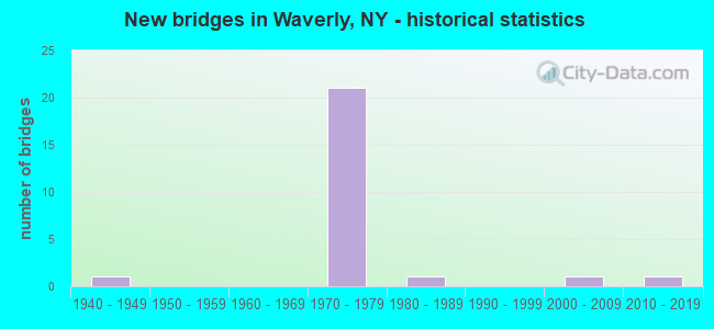
- New bridges - historical statistics
- 11940-1949
- 211970-1979
- 11980-1989
- 12000-2009
- 12010-2019


- Bridge Condition - Deck
- 7.1%Very good
- 35.7%Good
- 57.1%Satisfactory

- Bridge Condition - Superstructure
- 7.1%Excellent
- 14.3%Good
- 57.1%Satisfactory
- 21.4%Fair

- Bridge Condition - Substructure
- 7.1%Very good
- 21.4%Good
- 21.4%Satisfactory
- 50.0%Fair

- Bridge Condition - Channel
- 12.5%Very good
- 12.5%Good
- 25.0%Satisfactory
- 50.0%Fair

- Bridge Condition - Culverts
- 50.0%Good
- 50.0%Satisfactory
Find on map >> Show street view
Structure Number: 101286, Location: JCT RTE 17C + CAYUTA CK (Lat: 42.010703, Lng: -76.526358), Route carried "on" structure: State highway 17C, Year Built: 2017, Status: Open, Structure Length: 4.82m (15.81ft), Average Daily Traffic: 3,605 (year 2019), Truck Traffic: 7%, Average Future Daily Traffic: 4,379 (year 2040), Design Load: HL 93, Features Intersected: CAYUTA CREEK
Minimum Vertical Clearance: 30+ m (98+ ft), Kilometerpoint: 0.048, Lanes on structure: 2, Base Highway Network: Yes, Owner: State Highway Agency, Approaching Roadway Width: 10.4m (34.1ft), Skew: 3 degrees, Material/Design: Steel continuous, Design/Construction: Stringer/Multi-beam, Number Of Spans In Main Unit: 2, Length of Maximum Span: 23.8m (78.1ft), Curb or Sidewalk Widths: Left: 1.5m (4.9ft), Right: 1.5m (4.9ft), Curb-To-Curb Width: 10.4m (34.1ft), Out-to-Out Width: 14.7m (48.2ft)
Condition: Deck: Very good, Superstructure: Excellent, Substructure: Very good, Channel: Very good, Operating Rating: 95.3 metric tons, Method Used To Determine Operating Rating: Load Factor (LF), Inventory Rating: 56.2 metric tons, Method Used To Determine Inventory Rating: Load Factor (LF), Structural Evaluation: Equal to present desirable criteria, Deck Geometry: Somewhat better than minimum adequacy, Waterway Adequacy: Somewhat better than minimum adequacy, Approach Roadway Alignment: Equal to present desirable criteria, Length Of Structure Improvement: 4.81m (15.78ft), Designated Inspection Frequency: Every 24 months, Inspection Date: September 2021, Bridge Improvement Cost: $1,604,000, Roadway Improvement Cost: $939,000, Total Project Cost: $2,543,000 ( Estimate for 2021), Deck Structure Type: Concrete Cast-file-Place, Wearing Surface/Protective System: Wearing Surface: Integral Concrete, Deck Protection: Epoxy Coated Reinforcing
Find on map >> Show street view
Structure Number: 106126, Location: JCT RTS 17 + 220 (Lat: 41.999322, Lng: -76.548700), Route carried "on" structure: US 220X, Year Built: 1971, Status: Open, Structure Length: 6.83m (22.41ft), Average Daily Traffic: 284 (year 1988), Truck Traffic: 10%, Average Future Daily Traffic: 398 (year 2008), Design Load: HS 20+Mod, Features Intersected: RTE 17
Minimum Vertical Clearance: 30+ m (98+ ft), Kilometerpoint: 0.161, Lanes on structure: 5, Lanes under structure: 5, Base Highway Network: Yes, Owner: State Highway Agency, Approaching Roadway Width: 17.1m (56.1ft), Skew: 2 degrees, Material/Design: Steel continuous, Design/Construction: Stringer/Multi-beam, Number Of Spans In Main Unit: 2, Length of Maximum Span: 37.7m (123.7ft), Curb or Sidewalk Widths: Left: 0.5m (1.6ft), Right: 0.5m (1.6ft), Curb-To-Curb Width: 17.1m (56.1ft), Out-to-Out Width: 18.6m (61.0ft)
Condition: Deck: Good, Superstructure: Satisfactory, Substructure: Good, Operating Rating: 61.7 metric tons, Method Used To Determine Operating Rating: Load Factor (LF), Inventory Rating: 37.2 metric tons, Method Used To Determine Inventory Rating: Load Factor (LF), Structural Evaluation: Equal to present minimum criteria, Deck Geometry: High priority of replacement, Underclear: Better than present minimum criteria, Approach Roadway Alignment: Equal to present desirable criteria, Length Of Structure Improvement: 6.82m (22.38ft), Designated Inspection Frequency: Every 24 months, Inspection Date: May 2021, Bridge Improvement Cost: $3,183,000, Roadway Improvement Cost: $1,864,000, Total Project Cost: $5,047,000 ( Estimate for 2021), Deck Structure Type: Concrete Cast-file-Place, Wearing Surface/Protective System: Wearing Surface: Epoxy Overlay
Find on map >> Show street view
Structure Number: 106127, Location: 0.2 MI N JCT RTS 17 + 220 (Lat: 42.000167, Lng: -76.548833), Route carried "on" structure: US 220, Year Built: 1970, Status: Open, Structure Length: 4.69m (15.39ft), Average Daily Traffic: 5,113 (year 2017), Truck Traffic: 4%, Average Future Daily Traffic: 6,211 (year 2040), Design Load: HS 20+Mod, Features Intersected: NORFOLK & SOUTHERN R.R.
Minimum Vertical Clearance: 30+ m (98+ ft), Kilometerpoint: 0.080, Lanes on structure: 4, Owner: State Highway Agency, Approaching Roadway Width: 17.1m (56.1ft), Material/Design: Steel, Design/Construction: Stringer/Multi-beam, Number Of Spans In Main Unit: 3, Length of Maximum Span: 19.5m (64.0ft), Curb-To-Curb Width: 17.1m (56.1ft), Out-to-Out Width: 18.6m (61.0ft)
Condition: Deck: Good, Superstructure: Fair, Substructure: Good, Operating Rating: 55.4 metric tons, Method Used To Determine Operating Rating: Load and Resistance Factor Rating (LRFR) rating reported by rating factor(RF) method using HL-93 loadings, Inventory Rating: 42.8 metric tons, Method Used To Determine Inventory Rating: Load and Resistance Factor Rating (LRFR) rating reported by rating factor(RF) method using HL-93 loadings, Structural Evaluation: Somewhat better than minimum adequacy, Deck Geometry: Somewhat better than minimum adequacy, Underclear: Better than present minimum criteria, Approach Roadway Alignment: Equal to present desirable criteria, Length Of Structure Improvement: 4.69m (15.39ft), Designated Inspection Frequency: Every 24 months, Inspection Date: November 2021, Bridge Improvement Cost: $2,132,000, Roadway Improvement Cost: $1,248,000, Total Project Cost: $3,380,000 ( Estimate for 2021), Deck Structure Type: Concrete Cast-file-Place, Wearing Surface/Protective System: Wearing Surface: Monolithic Concrete
Find on map >> Show street view
Structure Number: 1061481, Location: 0.5 MI E JCT RTS 17 + 220 (Lat: 41.998922, Lng: -76.541294), Route carried "on" structure: State highway 17, Year Built: 1973, Status: Open, Structure Length: 2.53m (8.30ft), Average Daily Traffic: 7,099 (year 2007), Truck Traffic: 27%, Average Future Daily Traffic: 11,077 (year 2040), Design Load: HS 20+Mod, Features Intersected: FULTON STREET
Minimum Vertical Clearance: 30+ m (98+ ft), Kilometerpoint: 1.368, Lanes on structure: 3, Lanes under structure: 2, Base Highway Network: Yes, Owner: State Highway Agency, Approaching Roadway Width: 15.8m (51.8ft), Material/Design: Steel, Design/Construction: Stringer/Multi-beam, Number Of Spans In Main Unit: 1, Length of Maximum Span: 24.3m (79.7ft), Curb-To-Curb Width: 15.7m (51.5ft), Out-to-Out Width: 16.7m (54.8ft)
Condition: Deck: Satisfactory, Superstructure: Satisfactory, Substructure: Satisfactory, Operating Rating: 84.4 metric tons, Method Used To Determine Operating Rating: Load Factor (LF), Inventory Rating: 49.9 metric tons, Method Used To Determine Inventory Rating: Load Factor (LF), Structural Evaluation: Equal to present minimum criteria, Deck Geometry: Better than present minimum criteria, Underclear: Somewhat better than minimum adequacy, Approach Roadway Alignment: Equal to present desirable criteria, Length Of Structure Improvement: 2.52m (8.27ft), Designated Inspection Frequency: Every 24 months, Inspection Date: October 2020, Bridge Improvement Cost: $1,459,000, Roadway Improvement Cost: $854,000, Total Project Cost: $2,314,000 ( Estimate for 2021), Deck Structure Type: Concrete Cast-file-Place, Wearing Surface/Protective System: Wearing Surface: Monolithic Concrete
Find on map >> Show street view
Structure Number: 1061482, Location: 0.5 MI E JCT RTS 17 + 220 (Lat: 41.998650, Lng: -76.541278), Route carried "on" structure: State highway 17, Year Built: 1973, Status: Open, Structure Length: 2.53m (8.30ft), Average Daily Traffic: 7,099 (year 2007), Truck Traffic: 27%, Average Future Daily Traffic: 11,077 (year 2040), Design Load: HS 20+Mod, Features Intersected: FULTON STREET
Minimum Vertical Clearance: 30+ m (98+ ft), Kilometerpoint: 1.368, Lanes on structure: 2, Lanes under structure: 2, Base Highway Network: Yes, Owner: State Highway Agency, Approaching Roadway Width: 12.2m (40.0ft), Material/Design: Steel, Design/Construction: Stringer/Multi-beam, Number Of Spans In Main Unit: 1, Length of Maximum Span: 24.3m (79.7ft), Curb-To-Curb Width: 12.0m (39.4ft), Out-to-Out Width: 12.9m (42.3ft)
Condition: Deck: Satisfactory, Superstructure: Satisfactory, Substructure: Satisfactory, Operating Rating: 94.3 metric tons, Method Used To Determine Operating Rating: Load Factor (LF), Inventory Rating: 56.2 metric tons, Method Used To Determine Inventory Rating: Load Factor (LF), Structural Evaluation: Equal to present minimum criteria, Deck Geometry: Better than present minimum criteria, Underclear: Somewhat better than minimum adequacy, Approach Roadway Alignment: Equal to present desirable criteria, Length Of Structure Improvement: 2.52m (8.27ft), Designated Inspection Frequency: Every 24 months, Inspection Date: October 2020, Bridge Improvement Cost: $1,128,000, Roadway Improvement Cost: $661,000, Total Project Cost: $1,789,000 ( Estimate for 2021), Deck Structure Type: Concrete Cast-file-Place, Wearing Surface/Protective System: Wearing Surface: Monolithic Concrete
Find on map >> Show street view
Structure Number: 106149, Location: 0.6 MI E JCT RTS 17 + 220 (Lat: 42.000847, Lng: -76.535697), Route carried "on" structure: Other road , Year Built: 1973, Status: Open, Structure Length: 11.52m (37.80ft), Average Daily Traffic: 4,219 (year 2020), Truck Traffic: 3%, Average Future Daily Traffic: 5,220 (year 2040), Design Load: HS 20+Mod, Features Intersected: Broad Street, Norfolk So, Facility Carried by Structure: PENNSYLVANIA AVE
Minimum Vertical Clearance: 30+ m (98+ ft), Kilometerpoint: 0.000, Lanes on structure: 2, Lanes under structure: 2, Owner: State Highway Agency, Approaching Roadway Width: 12.2m (40.0ft), Skew: 1 degrees, Material/Design: Steel continuous, Design/Construction: Stringer/Multi-beam, Number Of Spans In Main Unit: 4, Length of Maximum Span: 29.5m (96.8ft), Curb or Sidewalk Widths: Left: 1.2m (3.9ft), Right: 1.2m (3.9ft), Curb-To-Curb Width: 12.2m (40.0ft), Out-to-Out Width: 15.4m (50.5ft)
Condition: Deck: Satisfactory, Superstructure: Good, Substructure: Satisfactory, Operating Rating: 26.9 metric tons, Method Used To Determine Operating Rating: Load and Resistance Factor Rating (LRFR) rating reported by rating factor(RF) method using HL-93 loadings, Inventory Rating: 20.7 metric tons, Method Used To Determine Inventory Rating: Load and Resistance Factor Rating (LRFR) rating reported by rating factor(RF) method using HL-93 loadings, Structural Evaluation: Somewhat better than minimum adequacy, Deck Geometry: Equal to present minimum criteria, Underclear: Equal to present minimum criteria, Approach Roadway Alignment: Better than present minimum criteria, Length Of Structure Improvement: 11.52m (37.80ft), Designated Inspection Frequency: Every 24 months, Inspection Date: November 2021, Bridge Improvement Cost: $3,976,000, Roadway Improvement Cost: $2,328,000, Total Project Cost: $6,305,000 ( Estimate for 2021), Deck Structure Type: Concrete Cast-file-Place, Wearing Surface/Protective System: Wearing Surface: Epoxy Overlay
Find on map >> Show street view
Structure Number: 1061501, Location: JCT RTS 17 + 34 (Lat: 42.000219, Lng: -76.525003), Route carried "on" structure: State highway 17, Year Built: 1973, Status: Open, Structure Length: 3.29m (10.79ft), Average Daily Traffic: 7,235 (year 2020), Truck Traffic: 28%, Average Future Daily Traffic: 8,384 (year 2040), Design Load: HS 20+Mod, Features Intersected: CAYUTA AVE
Minimum Vertical Clearance: 30+ m (98+ ft), Kilometerpoint: 2.735, Lanes on structure: 3, Lanes under structure: 4, Base Highway Network: Yes, Owner: State Highway Agency, Approaching Roadway Width: 15.8m (51.8ft), Skew: 2 degrees, Material/Design: Steel, Design/Construction: Stringer/Multi-beam, Number Of Spans In Main Unit: 1, Length of Maximum Span: 32.0m (105.0ft), Curb-To-Curb Width: 15.5m (50.9ft), Out-to-Out Width: 16.4m (53.8ft)
Condition: Deck: Satisfactory, Superstructure: Satisfactory, Substructure: Fair, Operating Rating: 79.8 metric tons, Method Used To Determine Operating Rating: Load Factor (LF), Inventory Rating: 48.1 metric tons, Method Used To Determine Inventory Rating: Load Factor (LF), Structural Evaluation: Somewhat better than minimum adequacy, Deck Geometry: Somewhat better than minimum adequacy, Underclear: High priority of corrective action, Approach Roadway Alignment: Equal to present desirable criteria, Length Of Structure Improvement: 3.29m (10.79ft), Designated Inspection Frequency: Every 24 months, Inspection Date: June 2020, Bridge Improvement Cost: $1,769,000, Roadway Improvement Cost: $1,036,000, Total Project Cost: $2,805,000 ( Estimate for 2021), Deck Structure Type: Concrete Cast-file-Place, Wearing Surface/Protective System: Wearing Surface: Integral Concrete
Find on map >> Show street view
Structure Number: 1061502, Location: JCT RTS 17 + 34 (Lat: 41.999975, Lng: -76.524856), Route carried "on" structure: State highway 17, Year Built: 1973, Status: Open, Structure Length: 3.29m (10.79ft), Average Daily Traffic: 7,235 (year 2020), Truck Traffic: 28%, Average Future Daily Traffic: 8,384 (year 2040), Design Load: HS 20+Mod, Features Intersected: CAYUTA AVE
Minimum Vertical Clearance: 30+ m (98+ ft), Kilometerpoint: 2.735, Lanes on structure: 3, Lanes under structure: 4, Base Highway Network: Yes, Owner: State Highway Agency, Approaching Roadway Width: 15.5m (50.9ft), Skew: 2 degrees, Material/Design: Steel, Design/Construction: Stringer/Multi-beam, Number Of Spans In Main Unit: 1, Length of Maximum Span: 32.0m (105.0ft), Curb-To-Curb Width: 15.6m (51.2ft), Out-to-Out Width: 16.5m (54.1ft)
Condition: Deck: Satisfactory, Superstructure: Fair, Substructure: Fair, Operating Rating: 82.6 metric tons, Method Used To Determine Operating Rating: Load Factor (LF), Inventory Rating: 49.0 metric tons, Method Used To Determine Inventory Rating: Load Factor (LF), Structural Evaluation: Somewhat better than minimum adequacy, Deck Geometry: Somewhat better than minimum adequacy, Underclear: High priority of corrective action, Approach Roadway Alignment: Equal to present desirable criteria, Length Of Structure Improvement: 3.29m (10.79ft), Designated Inspection Frequency: Every 24 months, Inspection Date: June 2020, Bridge Improvement Cost: $1,819,000, Roadway Improvement Cost: $1,065,000, Total Project Cost: $2,885,000 ( Estimate for 2021), Deck Structure Type: Concrete Cast-file-Place, Wearing Surface/Protective System: Wearing Surface: Integral Concrete
Find on map >> Show street view
Structure Number: 106199, Location: 0.9 MI E JCT RTS 17 + 220 (Lat: 41.999564, Lng: -76.534817), Route carried "on" structure: Bypass Other road , Year Built: 1973, Status: Open, Structure Length: 5.70m (18.70ft), Average Daily Traffic: 4,219 (year 2020), Truck Traffic: 3%, Average Future Daily Traffic: 5,220 (year 2040), Design Load: HS 20+Mod, Features Intersected: RTE 17, Facility Carried by Structure: KEYSTONE AVENUE
Minimum Vertical Clearance: 30+ m (98+ ft), Kilometerpoint: 0.097, Lanes on structure: 2, Lanes under structure: 4, Owner: State Highway Agency, Approaching Roadway Width: 12.2m (40.0ft), Skew: 1 degrees, Material/Design: Steel, Design/Construction: Stringer/Multi-beam, Number Of Spans In Main Unit: 2, Length of Maximum Span: 27.4m (89.9ft), Curb or Sidewalk Widths: Left: 1.2m (3.9ft), Right: 1.2m (3.9ft), Curb-To-Curb Width: 12.2m (40.0ft), Out-to-Out Width: 15.4m (50.5ft)
Condition: Deck: Good, Superstructure: Satisfactory, Substructure: Fair, Operating Rating: 49.2 metric tons, Method Used To Determine Operating Rating: Load and Resistance Factor Rating (LRFR) rating reported by rating factor(RF) method using HL-93 loadings, Inventory Rating: 37.9 metric tons, Method Used To Determine Inventory Rating: Load and Resistance Factor Rating (LRFR) rating reported by rating factor(RF) method using HL-93 loadings, Structural Evaluation: Somewhat better than minimum adequacy, Deck Geometry: Equal to present minimum criteria, Underclear: Better than present minimum criteria, Approach Roadway Alignment: Equal to present desirable criteria, Length Of Structure Improvement: 5.69m (18.67ft), Designated Inspection Frequency: Every 24 months, Inspection Date: May 2021, Bridge Improvement Cost: $2,379,000, Roadway Improvement Cost: $1,393,000, Total Project Cost: $3,773,000 ( Estimate for 2021), Deck Structure Type: Concrete Cast-file-Place, Wearing Surface/Protective System: Wearing Surface: Integral Concrete
Find on map >> Show street view
Structure Number: 1062011, Location: 0.1 MI SE JCT RTS 17 + 34 (Lat: 42.000194, Lng: -76.523078), Route carried "on" structure: State highway 17, Year Built: 1973, Status: Open, Structure Length: 7.80m (25.59ft), Average Daily Traffic: 7,235 (year 2020), Truck Traffic: 28%, Average Future Daily Traffic: 8,384 (year 2040), Design Load: HS 20+Mod, Features Intersected: CAYUTA CREEK
Minimum Vertical Clearance: 30+ m (98+ ft), Kilometerpoint: 2.832, Lanes on structure: 2, Base Highway Network: Yes, Owner: State Highway Agency, Approaching Roadway Width: 11.9m (39.0ft), Skew: 1 degrees, Material/Design: Steel, Design/Construction: Stringer/Multi-beam, Number Of Spans In Main Unit: 2, Length of Maximum Span: 38.1m (125.0ft), Curb-To-Curb Width: 11.9m (39.0ft), Out-to-Out Width: 12.8m (42.0ft)
Condition: Deck: Satisfactory, Superstructure: Fair, Substructure: Fair, Channel: Satisfactory, Operating Rating: 84.4 metric tons, Method Used To Determine Operating Rating: Load Factor (LF), Inventory Rating: 50.8 metric tons, Method Used To Determine Inventory Rating: Load Factor (LF), Structural Evaluation: Somewhat better than minimum adequacy, Deck Geometry: Equal to present minimum criteria, Waterway Adequacy: Equal to present minimum criteria, Approach Roadway Alignment: Equal to present desirable criteria, Length Of Structure Improvement: 7.80m (25.59ft), Designated Inspection Frequency: Every 24 months, Inspection Date: September 2020, Bridge Improvement Cost: $2,319,000, Roadway Improvement Cost: $1,358,000, Total Project Cost: $3,676,000 ( Estimate for 2021), Deck Structure Type: Concrete Cast-file-Place, Wearing Surface/Protective System: Wearing Surface: Integral Concrete
Find on map >> Show street view
Structure Number: 1062012, Location: 0.1 MI SE JCT RTS 17 + 34 (Lat: 41.999972, Lng: -76.523194), Route carried "on" structure: State highway 17, Year Built: 1973, Status: Open, Structure Length: 7.80m (25.59ft), Average Daily Traffic: 7,235 (year 2020), Truck Traffic: 28%, Average Future Daily Traffic: 8,384 (year 2040), Design Load: HS 20+Mod, Features Intersected: CAYUTA CREEK
Minimum Vertical Clearance: 30+ m (98+ ft), Kilometerpoint: 2.832, Lanes on structure: 3, Base Highway Network: Yes, Owner: State Highway Agency, Approaching Roadway Width: 15.5m (50.9ft), Skew: 1 degrees, Material/Design: Steel, Design/Construction: Stringer/Multi-beam, Number Of Spans In Main Unit: 2, Length of Maximum Span: 38.1m (125.0ft), Curb-To-Curb Width: 15.5m (50.9ft), Out-to-Out Width: 16.5m (54.1ft)
Condition: Deck: Satisfactory, Superstructure: Satisfactory, Substructure: Fair, Channel: Satisfactory, Operating Rating: 90.7 metric tons, Method Used To Determine Operating Rating: Load Factor (LF), Inventory Rating: 54.4 metric tons, Method Used To Determine Inventory Rating: Load Factor (LF), Structural Evaluation: Somewhat better than minimum adequacy, Deck Geometry: Somewhat better than minimum adequacy, Waterway Adequacy: Equal to present minimum criteria, Approach Roadway Alignment: Equal to present desirable criteria, Length Of Structure Improvement: 7.80m (25.59ft), Designated Inspection Frequency: Every 24 months, Inspection Date: September 2020, Bridge Improvement Cost: $2,981,000, Roadway Improvement Cost: $1,746,000, Total Project Cost: $4,727,000 ( Estimate for 2021), Deck Structure Type: Concrete Cast-file-Place, Wearing Surface/Protective System: Wearing Surface: Integral Concrete
Find on map >> Show street view
Structure Number: 10908, Location: IN WAVERLY (Lat: 41.998611, Lng: -76.543853), Route carried "on" structure: State highway 17, Year Built: 1973, Status: Open, Structure Length: 0.73m (2.40ft), Average Daily Traffic: 14,197 (year 2007), Truck Traffic: 27%, Average Future Daily Traffic: 22,154 (year 2040), Design Load: HS 20+Mod, Features Intersected: DRY BROOK CREEK
Minimum Vertical Clearance: 30+ m (98+ ft), Kilometerpoint: 1.158, Lanes on structure: 6, Base Highway Network: Yes, Owner: State Highway Agency, Approaching Roadway Width: 15.2m (49.9ft), Skew: 27 degrees, Material/Design: Steel, Design/Construction: Culvert, Number Of Spans In Main Unit: 2, Length of Maximum Span: 2.7m (8.9ft)
Condition: Channel: Good, Culverts: Good, Operating Rating: 74.5 metric tons, Method Used To Determine Operating Rating: Field evaluation and documented engineering judgment, Inventory Rating: 32.7 metric tons, Method Used To Determine Inventory Rating: Field evaluation and documented engineering judgment, Structural Evaluation: Better than present minimum criteria, Waterway Adequacy: Equal to present desirable criteria, Approach Roadway Alignment: Equal to present desirable criteria, Length Of Structure Improvement: 0.73m (2.40ft), Designated Inspection Frequency: Every 24 months, Inspection Date: March 2021, Bridge Improvement Cost: $197,000, Roadway Improvement Cost: $116,000, Total Project Cost: $313,000 ( Estimate for 2021)
Find on map >> Show street view
Structure Number: 201285, Location: IN WAVERLY (Lat: 42.002800, Lng: -76.544978), Route carried "on" structure: Other road , Year Built: 1945, Status: Open, Structure Length: 0.76m (2.49ft), Average Daily Traffic: 7,310 (year 2020), Truck Traffic: 6%, Average Future Daily Traffic: 8,880 (year 2040), Design Load: HS 20, Features Intersected: DRY BROOK, Facility Carried by Structure: CHEMUNG STREET
Minimum Vertical Clearance: 30+ m (98+ ft), Kilometerpoint: 1.496, Lanes on structure: 2, Owner: Town or Township Highway Agency, Approaching Roadway Width: 7.9m (25.9ft), Material/Design: Concrete, Design/Construction: Culvert, Number Of Spans In Main Unit: 1, Length of Maximum Span: 6.7m (22.0ft), Curb or Sidewalk Widths: Left: 4.3m (14.1ft), Right: 3.7m (12.1ft), Curb-To-Curb Width: 7.9m (25.9ft), Out-to-Out Width: 15.6m (51.2ft)
Condition: Channel: Fair, Culverts: Satisfactory, Operating Rating: 48.1 metric tons, Method Used To Determine Operating Rating: Load Factor (LF), Inventory Rating: 28.1 metric tons, Method Used To Determine Inventory Rating: Load Factor (LF), Structural Evaluation: Equal to present minimum criteria, Deck Geometry: High priority of replacement, Waterway Adequacy: Meets minimum limits, Approach Roadway Alignment: Equal to present desirable criteria, Length Of Structure Improvement: 0.76m (2.49ft), Designated Inspection Frequency: Every 24 months, Inspection Date: May 2021, Bridge Improvement Cost: $311,000, Roadway Improvement Cost: $182,000, Total Project Cost: $494,000 ( Estimate for 2021)
Find on map >> Show street view
Structure Number: 221914, Location: IN WAVERLY (Lat: 42.006197, Lng: -76.549778), Route carried "on" structure: Other road , Year Built: 2002, Status: Open, Structure Length: 0.91m (2.99ft), Average Daily Traffic: 96 (year 2016), Truck Traffic: 7%, Average Future Daily Traffic: 134 (year 2036), Design Load: HS 25 or greater, Features Intersected: DRY BROOK, Facility Carried by Structure: CLINTON AVENUE
Minimum Vertical Clearance: 30+ m (98+ ft), Kilometerpoint: 0.032, Lanes on structure: 2, Owner: Town or Township Highway Agency, Approaching Roadway Width: 5.5m (18.0ft), Skew: 3 degrees, Material/Design: Concrete, Design/Construction: Frame, Number Of Spans In Main Unit: 1, Length of Maximum Span: 7.0m (23.0ft), Curb-To-Curb Width: 6.4m (21.0ft), Out-to-Out Width: 7.3m (24.0ft)
Condition: Deck: Satisfactory, Superstructure: Satisfactory, Substructure: Good, Channel: Fair, Operating Rating: 77.6 metric tons, Method Used To Determine Operating Rating: Field evaluation and documented engineering judgment, Inventory Rating: 40.8 metric tons, Method Used To Determine Inventory Rating: Field evaluation and documented engineering judgment, Structural Evaluation: Equal to present minimum criteria, Deck Geometry: Somewhat better than minimum adequacy, Waterway Adequacy: Meets minimum limits, Approach Roadway Alignment: Equal to present minimum criteria, Length Of Structure Improvement: 0.91m (2.99ft), Designated Inspection Frequency: Every 24 months, Inspection Date: August 2021, Bridge Improvement Cost: $216,000, Roadway Improvement Cost: $127,000, Total Project Cost: $343,000 ( Estimate for 2021), Wearing Surface/Protective System: Wearing Surface: Bituminous
Find on map >> Show street view
Structure Number: 221915, Location: IN WAVERLY (Lat: 42.008422, Lng: -76.526644), Route carried "on" structure: Other road , Year Built: 1986, Status: Open, Structure Length: 2.96m (9.71ft), Average Daily Traffic: 383 (year 2016), Truck Traffic: 7%, Average Future Daily Traffic: 536 (year 2036), Features Intersected: CAYUTA CREEK, Facility Carried by Structure: ITHACA STREET
Minimum Vertical Clearance: 30+ m (98+ ft), Kilometerpoint: 0.531, Lanes on structure: 2, Owner: County Highway Agency, Approaching Roadway Width: 7.3m (24.0ft), Material/Design: Steel, Design/Construction: Stringer/Multi-beam, Number Of Spans In Main Unit: 1, Length of Maximum Span: 28.0m (91.9ft), Curb or Sidewalk Widths: Left: 2.0m (6.6ft), Right: 0.0m, Curb-To-Curb Width: 7.2m (23.6ft), Out-to-Out Width: 9.6m (31.5ft)
Condition: Deck: Good, Superstructure: Satisfactory, Substructure: Fair, Channel: Fair, Operating Rating: 64.4 metric tons, Method Used To Determine Operating Rating: Load Factor (LF), Inventory Rating: 38.1 metric tons, Method Used To Determine Inventory Rating: Load Factor (LF), Structural Evaluation: Somewhat better than minimum adequacy, Deck Geometry: Meets minimum limits, Waterway Adequacy: Somewhat better than minimum adequacy, Approach Roadway Alignment: Equal to present desirable criteria, Length Of Structure Improvement: 2.95m (9.68ft), Designated Inspection Frequency: Every 24 months, Underwater Inspection Frequency: Every 60 months, Inspection Date: May 2021, Underwater Inspection Date: August 2019, Bridge Improvement Cost: $883,000, Roadway Improvement Cost: $517,000, Total Project Cost: $1,400,000 ( Estimate for 2021), Deck Structure Type: Wood or Timber, Wearing Surface/Protective System: Wearing Surface: Bituminous
Find on map >> Show street view
Structure Number: 221916, Location: IN WAVERLY (Lat: 42.004756, Lng: -76.547658), Route carried "on" structure: Other road , Year Built: 1977, Year Reconstructed: 2002, Status: Open, Structure Length: 0.79m (2.59ft), Average Daily Traffic: 526 (year 2018), Truck Traffic: 4%, Average Future Daily Traffic: 650 (year 2040), Features Intersected: DRY BROOK, Facility Carried by Structure: PINE STREET
Minimum Vertical Clearance: 30+ m (98+ ft), Kilometerpoint: 0.451, Lanes on structure: 2, Owner: Town or Township Highway Agency, Approaching Roadway Width: 8.8m (28.9ft), Skew: 2 degrees, Material/Design: Prestressed concrete, Design/Construction: Box Beam or Girders - Multiple, Number Of Spans In Main Unit: 1, Length of Maximum Span: 6.7m (22.0ft), Curb or Sidewalk Widths: Left: 2.9m (9.5ft), Right: 2.8m (9.2ft), Curb-To-Curb Width: 14.5m (47.6ft), Out-to-Out Width: 14.7m (48.2ft)
Condition: Deck: Good, Superstructure: Good, Substructure: Fair, Channel: Fair, Operating Rating: 97.1 metric tons, Method Used To Determine Operating Rating: Load Factor (LF), Inventory Rating: 58.1 metric tons, Method Used To Determine Inventory Rating: Load Factor (LF), Structural Evaluation: Somewhat better than minimum adequacy, Deck Geometry: Superior to present desirable criteria, Waterway Adequacy: Meets minimum limits, Approach Roadway Alignment: Better than present minimum criteria, Length Of Structure Improvement: 0.79m (2.59ft), Designated Inspection Frequency: Every 24 months, Inspection Date: May 2021, Bridge Improvement Cost: $381,000, Roadway Improvement Cost: $223,000, Total Project Cost: $604,000 ( Estimate for 2021), Wearing Surface/Protective System: Wearing Surface: Bituminous
Find on map >> Show street view
Structure Number: 106126, Location: JCT RTS 17 + 220 (Lat: 41.999322, Lng: -76.548700), Route carried "under" structure: State highway 17, Year Built: 1971, Structure Length: 0. m, Average Daily Traffic: 7,007 (year 1999), Features Intersected: RTE 17, Facility Carried by Structure: RTE 220X
Minimum Vertical Clearance: 5.94m (19.49ft), Kilometerpoint: 0.772, Lanes on structure: 5, Lanes under structure: 5, Material/Design: Steel continuous, Design/Construction: Stringer/Multi-beam, Length of Maximum Span: 37.7m (123.7ft)
Find on map >> Show street view
Structure Number: 1061481, Location: 0.5 MI E JCT RTS 17 + 220 (Lat: 41.998922, Lng: -76.541294), Route carried "under" structure: Other road , Year Built: 1973, Structure Length: 0. m, Features Intersected: FULTON STREET, Facility Carried by Structure: RTE 17
Minimum Vertical Clearance: 4.42m (14.50ft), Kilometerpoint: 0.000, Lanes on structure: 3, Lanes under structure: 2, Material/Design: Steel, Design/Construction: Stringer/Multi-beam, Length of Maximum Span: 24.3m (79.7ft)
Find on map >> Show street view
Structure Number: 1061482, Location: 0.5 MI E JCT RTS 17 + 220 (Lat: 41.998650, Lng: -76.541278), Route carried "under" structure: Other road , Year Built: 1973, Structure Length: 0. m, Features Intersected: FULTON STREET, Facility Carried by Structure: RTE 17
Minimum Vertical Clearance: 4.95m (16.24ft), Kilometerpoint: 0.000, Lanes on structure: 2, Lanes under structure: 2, Material/Design: Steel, Design/Construction: Stringer/Multi-beam, Length of Maximum Span: 24.3m (79.7ft)
Find on map >> Show street view
Structure Number: 106149, Location: 0.6 MI E JCT RTS 17 + 220 (Lat: 42.000847, Lng: -76.535697), Route carried "under" structure: ServiceOther road , Year Built: 1973, Structure Length: 0. m, Features Intersected: Broad Street, Norfolk So, Facility Carried by Structure: PENNSYLVANIA AVE
Minimum Vertical Clearance: 5.64m (18.50ft), Kilometerpoint: 0.000, Lanes on structure: 2, Lanes under structure: 2, Material/Design: Steel continuous, Design/Construction: Stringer/Multi-beam, Length of Maximum Span: 29.5m (96.8ft)
Find on map >> Show street view
Structure Number: 1061501, Location: JCT RTS 17 + 34 (Lat: 42.000219, Lng: -76.525003), Route carried "under" structure: ServiceOther road , Year Built: 1973, Structure Length: 0. m, Features Intersected: CAYUTA AVE, Facility Carried by Structure: RTE 17
Minimum Vertical Clearance: 4.88m (16.01ft), Kilometerpoint: 0.000, Lanes on structure: 3, Lanes under structure: 4, Material/Design: Steel, Design/Construction: Stringer/Multi-beam, Length of Maximum Span: 32.0m (105.0ft)
Find on map >> Show street view
Structure Number: 1061502, Location: JCT RTS 17 + 34 (Lat: 41.999975, Lng: -76.524856), Route carried "under" structure: ServiceOther road , Year Built: 1973, Structure Length: 0. m, Features Intersected: CAYUTA AVE, Facility Carried by Structure: RTE 17
Minimum Vertical Clearance: 5.18m (16.99ft), Kilometerpoint: 0.000, Lanes on structure: 3, Lanes under structure: 4, Material/Design: Steel, Design/Construction: Stringer/Multi-beam, Length of Maximum Span: 32.0m (105.0ft)
Find on map >> Show street view
Structure Number: 106199, Location: 0.9 MI E JCT RTS 17 + 220 (Lat: 41.999564, Lng: -76.534817), Route carried "under" structure: State highway 17, Year Built: 1973, Structure Length: 0. m, Average Daily Traffic: 7,007 (year 1999), Features Intersected: RTE 17, Facility Carried by Structure: KEYSTONE AVENUE
Minimum Vertical Clearance: 5.51m (18.08ft), Kilometerpoint: 1.947, Lanes on structure: 2, Lanes under structure: 4, Material/Design: Steel, Design/Construction: Stringer/Multi-beam, Length of Maximum Span: 27.4m (89.9ft)
Find on map >> Show street view
Structure Number: 7062, Location: 1.1 MI E JCT SH17 & US220 (Lat: 41.999997, Lng: -76.529314), Route carried "under" structure: State highway 17, Year Built: 1973, Structure Length: 0. m, Average Daily Traffic: 10,800 (year 1977), Features Intersected: 17 17 65063002 WB, RTE 1, Facility Carried by Structure: NORFOLK SOUTHERN
Minimum Vertical Clearance: 5.54m (18.18ft), Kilometerpoint: 2.381, Lanes under structure: 6, Material/Design: Steel continuous, Design/Construction: Girder and Floorbeam System, Length of Maximum Span: 42.9m (140.7ft)
Find on map >> Show street view
Structure Number: 7062, Location: 1.1 MI E JCT SH17 & US220 (Lat: 41.999997, Lng: -76.529314), Route carried "under" structure: State highway , Year Built: 1973, Structure Length: 0. m, Features Intersected: 17 17 65063002 WB, RTE 1, Facility Carried by Structure: NORFOLK SOUTHERN
Minimum Vertical Clearance: 5.33m (17.49ft), Kilometerpoint: 2.381, Lanes under structure: 3, Material/Design: Steel continuous, Design/Construction: Girder and Floorbeam System, Length of Maximum Span: 42.9m (140.7ft)