Bridge Statistics for Wawayanda, New York (NY)
Condition, Traffic, Stress, Structural Evaluation, Project Costs
- National Bridge Inventory (NBI) Statistics
- 39Number of bridges
- 338ft / 103mTotal length
- $86,050,000Total costs
- 273,750Total average daily traffic
- 34,932Total average daily truck traffic
- National Bridge Inventory (NBI) Registered Bridges for Wawayanda
- No street view available for this location
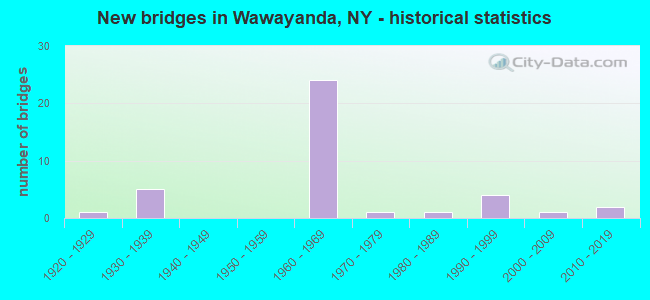
- New bridges - historical statistics
- 11920-1929
- 51930-1939
- 241960-1969
- 11970-1979
- 11980-1989
- 41990-1999
- 12000-2009
- 22010-2019
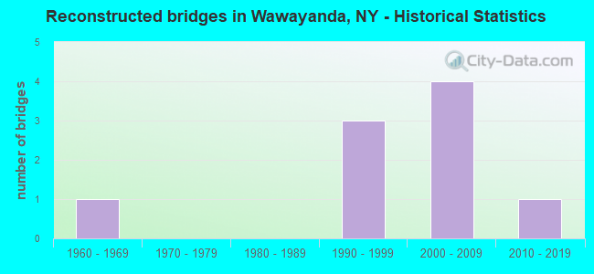
- Reconstructed bridges - Historical Statistics
- 11960-1969
- 01970-1979
- 01980-1989
- 31990-1999
- 42000-2009
- 12010-2019
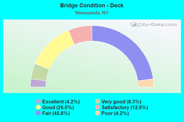
- Bridge Condition - Deck
- 4.2%Excellent
- 8.3%Very good
- 25.0%Good
- 12.5%Satisfactory
- 45.8%Fair
- 4.2%Poor
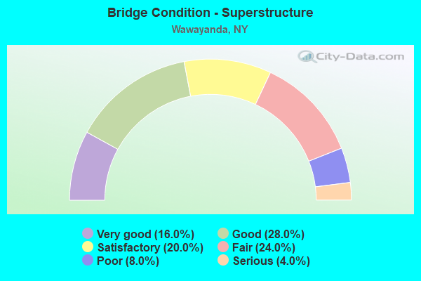
- Bridge Condition - Superstructure
- 16.0%Very good
- 28.0%Good
- 20.0%Satisfactory
- 24.0%Fair
- 8.0%Poor
- 4.0%Serious
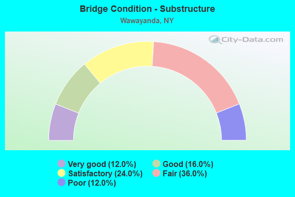
- Bridge Condition - Substructure
- 12.0%Very good
- 16.0%Good
- 24.0%Satisfactory
- 36.0%Fair
- 12.0%Poor
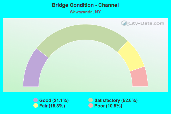
- Bridge Condition - Channel
- 21.1%Good
- 52.6%Satisfactory
- 15.8%Fair
- 10.5%Poor
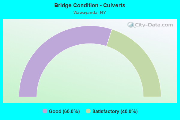
- Bridge Condition - Culverts
- 60.0%Good
- 40.0%Satisfactory
Find on map >> Show street view
Structure Number: 100309, Location: IN S.CENTERVILLE ON US 6 (Lat: 41.384375, Lng: -74.523917), Route carried "on" structure: US 6, Year Built: 1935, Status: Open, Structure Length: 0.82m (2.69ft), Average Daily Traffic: 2,289 (year 2020), Truck Traffic: 5%, Average Future Daily Traffic: 3,205 (year 2040), Design Load: H 20, Features Intersected: TRB INDIGOT CREEK
Minimum Vertical Clearance: 30+ m (98+ ft), Kilometerpoint: 18.713, Lanes on structure: 2, Base Highway Network: Yes, Owner: State Highway Agency, Approaching Roadway Width: 8.5m (27.9ft), Material/Design: Concrete, Design/Construction: Slab, Number Of Spans In Main Unit: 1, Length of Maximum Span: 7.3m (24.0ft), Curb-To-Curb Width: 7.9m (25.9ft), Out-to-Out Width: 9.1m (29.9ft)
Condition: Deck: Fair, Superstructure: Fair, Substructure: Fair, Channel: Poor, Operating Rating: 66.2 metric tons, Method Used To Determine Operating Rating: Load Factor (LF), Inventory Rating: 39.9 metric tons, Method Used To Determine Inventory Rating: Load Factor (LF), Structural Evaluation: Somewhat better than minimum adequacy, Deck Geometry: High priority of corrective action, Waterway Adequacy: Meets minimum limits, Approach Roadway Alignment: Meets minimum limits, Length Of Structure Improvement: 0.82m (2.69ft), Designated Inspection Frequency: Every 24 months, Inspection Date: July 2021, Bridge Improvement Cost: $378,000, Roadway Improvement Cost: $221,000, Total Project Cost: $600,000 ( Estimate for 2021), Wearing Surface/Protective System: Wearing Surface: Bituminous
Find on map >> Show street view
Structure Number: 10031, Location: 2.4 MI W JCT. RTS 6&284 (Lat: 41.385125, Lng: -74.519844), Route carried "on" structure: US 6, Year Built: 1993, Status: Open, Structure Length: 1.98m (6.50ft), Average Daily Traffic: 4,055 (year 2020), Truck Traffic: 4%, Average Future Daily Traffic: 5,677 (year 2040), Design Load: HS 20, Features Intersected: INDIGOT CREEK
Minimum Vertical Clearance: 30+ m (98+ ft), Kilometerpoint: 19.067, Lanes on structure: 2, Base Highway Network: Yes, Owner: State Highway Agency, Approaching Roadway Width: 8.5m (27.9ft), Material/Design: Prestressed concrete, Design/Construction: Box Beam or Girders - Multiple, Number Of Spans In Main Unit: 1, Length of Maximum Span: 18.8m (61.7ft), Curb-To-Curb Width: 8.5m (27.9ft), Out-to-Out Width: 9.3m (30.5ft)
Condition: Deck: Fair, Superstructure: Poor, Substructure: Good, Channel: Satisfactory, Operating Rating: 31.8 metric tons, Method Used To Determine Operating Rating: Load and Resistance Factor Rating (LRFR) rating reported by rating factor(RF) method using HL-93 loadings, Inventory Rating: 24.6 metric tons, Method Used To Determine Inventory Rating: Load and Resistance Factor Rating (LRFR) rating reported by rating factor(RF) method using HL-93 loadings, Structural Evaluation: Meets minimum limits, Deck Geometry: Meets minimum limits, Waterway Adequacy: Somewhat better than minimum adequacy, Approach Roadway Alignment: Equal to present desirable criteria, Length Of Structure Improvement: 1.98m (6.50ft), Designated Inspection Frequency: Every 24 months, Inspection Date: March 2021, Bridge Improvement Cost: $470,000, Roadway Improvement Cost: $275,000, Total Project Cost: $745,000 ( Estimate for 2021), Wearing Surface/Protective System: Wearing Surface: Bituminous
Find on map >> Show street view
Structure Number: 100311, Location: 0.2 MI W JCT RTS 6+284 (Lat: 41.391553, Lng: -74.478261), Route carried "on" structure: US 6, Year Built: 1935, Status: Open, Structure Length: 0.79m (2.59ft), Average Daily Traffic: 4,055 (year 2020), Truck Traffic: 4%, Average Future Daily Traffic: 5,017 (year 2040), Design Load: H 20, Features Intersected: JOE CREEK
Minimum Vertical Clearance: 30+ m (98+ ft), Kilometerpoint: 22.623, Lanes on structure: 2, Base Highway Network: Yes, Owner: State Highway Agency, Approaching Roadway Width: 9.8m (32.2ft), Skew: 3 degrees, Material/Design: Concrete, Design/Construction: Slab, Number Of Spans In Main Unit: 1, Length of Maximum Span: 6.7m (22.0ft), Curb-To-Curb Width: 8.2m (26.9ft), Out-to-Out Width: 9.4m (30.8ft)
Condition: Deck: Fair, Superstructure: Fair, Substructure: Fair, Channel: Fair, Operating Rating: 62.6 metric tons, Method Used To Determine Operating Rating: Load Factor (LF), Inventory Rating: 37.2 metric tons, Method Used To Determine Inventory Rating: Load Factor (LF), Structural Evaluation: Somewhat better than minimum adequacy, Deck Geometry: High priority of corrective action, Waterway Adequacy: Meets minimum limits, Approach Roadway Alignment: Meets minimum limits, Length Of Structure Improvement: 0.79m (2.59ft), Designated Inspection Frequency: Every 24 months, Inspection Date: August 2021, Bridge Improvement Cost: $395,000, Roadway Improvement Cost: $231,000, Total Project Cost: $626,000 ( Estimate for 2021), Wearing Surface/Protective System: Wearing Surface: Bituminous
Find on map >> Show street view
Structure Number: 100312, Location: 0.3 MI E JCT RTS 6 & 284 (Lat: 41.390933, Lng: -74.469392), Route carried "on" structure: US 6, Year Built: 1993, Status: Open, Structure Length: 1.49m (4.89ft), Average Daily Traffic: 8,257 (year 2020), Truck Traffic: 6%, Average Future Daily Traffic: 10,030 (year 2040), Design Load: HS 20, Features Intersected: CATLIN CREEK
Minimum Vertical Clearance: 30+ m (98+ ft), Kilometerpoint: 23.427, Lanes on structure: 2, Base Highway Network: Yes, Owner: State Highway Agency, Approaching Roadway Width: 9.1m (29.9ft), Skew: 2 degrees, Material/Design: Prestressed concrete, Design/Construction: Box Beam or Girders - Multiple, Number Of Spans In Main Unit: 1, Length of Maximum Span: 13.7m (44.9ft), Curb-To-Curb Width: 9.2m (30.2ft), Out-to-Out Width: 10.0m (32.8ft)
Condition: Deck: Fair, Superstructure: Fair, Substructure: Fair, Channel: Satisfactory, Operating Rating: 99.8 metric tons, Method Used To Determine Operating Rating: Load Factor (LF), Inventory Rating: 48.1 metric tons, Method Used To Determine Inventory Rating: Load Factor (LF), Structural Evaluation: Somewhat better than minimum adequacy, Deck Geometry: High priority of corrective action, Waterway Adequacy: Meets minimum limits, Approach Roadway Alignment: Equal to present desirable criteria, Length Of Structure Improvement: 1.49m (4.89ft), Designated Inspection Frequency: Every 24 months, Inspection Date: October 2021, Bridge Improvement Cost: $434,000, Roadway Improvement Cost: $254,000, Total Project Cost: $689,000 ( Estimate for 2021), Wearing Surface/Protective System: Wearing Surface: Bituminous
Find on map >> Show street view
Structure Number: 105243, Location: 6.4 MI E I84 INT 2 (Lat: 41.400578, Lng: -74.519017), Route carried "on" structure: State highway , Year Built: 1967, Status: Open, Structure Length: 8.84m (29.00ft), Average Daily Traffic: 1,269 (year 2018), Truck Traffic: 13%, Average Future Daily Traffic: 1,777 (year 2038), Design Load: HS 20, Features Intersected: 84I 84I83011101 WB, RTE, Facility Carried by Structure: SO CENTERVILLE RD
Minimum Vertical Clearance: 30+ m (98+ ft), Kilometerpoint: 1.915, Lanes on structure: 2, Lanes under structure: 4, Owner: State Highway Agency, Approaching Roadway Width: 9.8m (32.2ft), Material/Design: Steel, Design/Construction: Stringer/Multi-beam, Number Of Spans In Main Unit: 2, Length of Maximum Span: 43.5m (142.7ft), Curb or Sidewalk Widths: Left: 0.5m (1.6ft), Right: 0.5m (1.6ft), Curb-To-Curb Width: 7.9m (25.9ft), Out-to-Out Width: 9.4m (30.8ft)
Condition: Deck: Good, Superstructure: Good, Substructure: Good, Operating Rating: 70.8 metric tons, Method Used To Determine Operating Rating: Load Factor (LF), Inventory Rating: 41.7 metric tons, Method Used To Determine Inventory Rating: Load Factor (LF), Structural Evaluation: Better than present minimum criteria, Deck Geometry: Meets minimum limits, Underclear: Meets minimum limits, Approach Roadway Alignment: Equal to present desirable criteria, Length Of Structure Improvement: 8.83m (28.97ft), Designated Inspection Frequency: Every 24 months, Inspection Date: October 2021, Bridge Improvement Cost: $3,302,000, Roadway Improvement Cost: $1,933,000, Total Project Cost: $5,235,000 ( Estimate for 2021), Deck Structure Type: Concrete Cast-file-Place, Wearing Surface/Protective System: Wearing Surface: Integral Concrete
Find on map >> Show street view
Structure Number: 1052441, Location: 5.8 MI E I84 INT 2 (Lat: 41.404386, Lng: -74.511258), Route carried "on" structure: Interstate 84, Year Built: 1967, Status: Open, Structure Length: 1.28m (4.20ft), Average Daily Traffic: 14,398 (year 2009), Truck Traffic: 20%, Design Load: HS 20, Features Intersected: INDIGOT CREEK
Minimum Vertical Clearance: 30+ m (98+ ft), Kilometerpoint: 16.975, Lanes on structure: 2, Base Highway Network: Yes, Owner: State Highway Agency, Approaching Roadway Width: 11.6m (38.1ft), Skew: 5 degrees, Material/Design: Concrete continuous, Design/Construction: Culvert, Number Of Spans In Main Unit: 2, Length of Maximum Span: 5.8m (19.0ft)
Condition: Channel: Satisfactory, Culverts: Satisfactory, Structural Evaluation: Equal to present minimum criteria, Waterway Adequacy: Superior to present desirable criteria, Approach Roadway Alignment: Equal to present desirable criteria, Length Of Structure Improvement: 1.28m (4.20ft), Designated Inspection Frequency: Every 24 months, Inspection Date: November 2021, Bridge Improvement Cost: $418,000, Roadway Improvement Cost: $245,000, Total Project Cost: $662,000 ( Estimate for 2021)
Find on map >> Show street view
Structure Number: 1052442, Location: 5.8 MI E I84 INT 2 (Lat: 41.403469, Lng: -74.511953), Route carried "on" structure: Interstate 84, Year Built: 1967, Status: Open, Structure Length: 1.28m (4.20ft), Average Daily Traffic: 12,693 (year 2019), Truck Traffic: 25%, Average Future Daily Traffic: 22,252 (year 2040), Design Load: HS 20, Features Intersected: INDIGOT CREEK
Minimum Vertical Clearance: 30+ m (98+ ft), Kilometerpoint: 17.039, Lanes on structure: 2, Base Highway Network: Yes, Owner: State Highway Agency, Approaching Roadway Width: 11.6m (38.1ft), Skew: 5 degrees, Material/Design: Concrete continuous, Design/Construction: Culvert, Number Of Spans In Main Unit: 2, Length of Maximum Span: 5.8m (19.0ft)
Condition: Channel: Satisfactory, Culverts: Satisfactory, Structural Evaluation: Equal to present minimum criteria, Waterway Adequacy: Superior to present desirable criteria, Approach Roadway Alignment: Equal to present desirable criteria, Length Of Structure Improvement: 1.28m (4.20ft), Designated Inspection Frequency: Every 24 months, Inspection Date: November 2021, Bridge Improvement Cost: $418,000, Roadway Improvement Cost: $245,000, Total Project Cost: $662,000 ( Estimate for 2021)
Find on map >> Show street view
Structure Number: 105245, Location: 6.6 MI E I84 INT 2 (Lat: 41.406853, Lng: -74.499811), Route carried "on" structure: Other road , Year Built: 1967, Status: Open, Structure Length: 8.50m (27.89ft), Average Daily Traffic: 1,405 (year 2015), Truck Traffic: 4%, Average Future Daily Traffic: 1,967 (year 2035), Design Load: HS 20, Features Intersected: 84I 84I83011113 WB, RTE, Facility Carried by Structure: MT. ORANGE ROAD
Minimum Vertical Clearance: 30+ m (98+ ft), Kilometerpoint: 3.057, Lanes on structure: 2, Lanes under structure: 4, Owner: State Highway Agency, Approaching Roadway Width: 6.7m (22.0ft), Skew: 1 degrees, Material/Design: Steel, Design/Construction: Stringer/Multi-beam, Number Of Spans In Main Unit: 2, Length of Maximum Span: 41.4m (135.8ft), Curb or Sidewalk Widths: Left: 0.5m (1.6ft), Right: 0.5m (1.6ft), Curb-To-Curb Width: 7.9m (25.9ft), Out-to-Out Width: 9.4m (30.8ft)
Condition: Deck: Good, Superstructure: Satisfactory, Substructure: Satisfactory, Operating Rating: 34.0 metric tons, Method Used To Determine Operating Rating: Load and Resistance Factor Rating (LRFR) rating reported by rating factor(RF) method using HL-93 loadings, Inventory Rating: 26.2 metric tons, Method Used To Determine Inventory Rating: Load and Resistance Factor Rating (LRFR) rating reported by rating factor(RF) method using HL-93 loadings, Structural Evaluation: Equal to present minimum criteria, Deck Geometry: Meets minimum limits, Underclear: Better than present minimum criteria, Approach Roadway Alignment: Equal to present desirable criteria, Length Of Structure Improvement: 8.50m (27.89ft), Designated Inspection Frequency: Every 24 months, Inspection Date: August 2021, Bridge Improvement Cost: $3,441,000, Roadway Improvement Cost: $2,015,000, Total Project Cost: $5,456,000 ( Estimate for 2021), Deck Structure Type: Concrete Cast-file-Place, Wearing Surface/Protective System: Wearing Surface: Integral Concrete
Find on map >> Show street view
Structure Number: 1052461, Location: 2 MI W JCT US 6 & I84 (Lat: 41.404339, Lng: -74.471658), Route carried "on" structure: Interstate 84, Year Built: 1967, Year Reconstructed: 2006, Status: Open, Structure Length: 2.99m (9.81ft), Average Daily Traffic: 14,398 (year 2009), Truck Traffic: 20%, Design Load: HS 20, Features Intersected: COUNTY ROAD 49
Minimum Vertical Clearance: 30+ m (98+ ft), Kilometerpoint: 20.370, Lanes on structure: 2, Lanes under structure: 2, Base Highway Network: Yes, Owner: State Highway Agency, Approaching Roadway Width: 13.1m (43.0ft), Skew: 3 degrees, Material/Design: Steel, Design/Construction: Stringer/Multi-beam, Number Of Spans In Main Unit: 1, Length of Maximum Span: 27.4m (89.9ft), Curb-To-Curb Width: 12.1m (39.7ft), Out-to-Out Width: 13.0m (42.7ft)
Condition: Deck: Fair, Superstructure: Fair, Substructure: Satisfactory, Operating Rating: 67.1 metric tons, Method Used To Determine Operating Rating: Load Factor (LF), Inventory Rating: 39.9 metric tons, Method Used To Determine Inventory Rating: Load Factor (LF), Structural Evaluation: Somewhat better than minimum adequacy, Deck Geometry: Equal to present minimum criteria, Underclear: Equal to present minimum criteria, Approach Roadway Alignment: Equal to present desirable criteria, Length Of Structure Improvement: 2.98m (9.78ft), Designated Inspection Frequency: Every 24 months, Inspection Date: June 2021, Bridge Improvement Cost: $2,827,000, Roadway Improvement Cost: $1,656,000, Total Project Cost: $4,483,000 ( Estimate for 2021), Deck Structure Type: Concrete Cast-file-Place, Wearing Surface/Protective System: Wearing Surface: Integral Concrete
Find on map >> Show street view
Structure Number: 1052462, Location: 2 MI W JCT US 6 & I84 (Lat: 41.403697, Lng: -74.472661), Route carried "on" structure: Interstate 84, Year Built: 1967, Year Reconstructed: 2006, Status: Open, Structure Length: 4.08m (13.39ft), Average Daily Traffic: 12,693 (year 2019), Truck Traffic: 25%, Average Future Daily Traffic: 21,494 (year 2040), Design Load: HS 20, Features Intersected: COUNTY ROAD 49
Minimum Vertical Clearance: 30+ m (98+ ft), Kilometerpoint: 20.418, Lanes on structure: 2, Lanes under structure: 2, Base Highway Network: Yes, Owner: State Highway Agency, Approaching Roadway Width: 12.8m (42.0ft), Skew: 3 degrees, Material/Design: Steel, Design/Construction: Stringer/Multi-beam, Number Of Spans In Main Unit: 1, Length of Maximum Span: 37.7m (123.7ft), Curb-To-Curb Width: 12.0m (39.4ft), Out-to-Out Width: 13.1m (43.0ft)
Condition: Deck: Very good, Superstructure: Satisfactory, Substructure: Fair, Operating Rating: 68.0 metric tons, Method Used To Determine Operating Rating: Load Factor (LF), Inventory Rating: 32.7 metric tons, Method Used To Determine Inventory Rating: Load Factor (LF), Structural Evaluation: Somewhat better than minimum adequacy, Deck Geometry: Equal to present minimum criteria, Underclear: Equal to present minimum criteria, Approach Roadway Alignment: Equal to present desirable criteria, Length Of Structure Improvement: 4.08m (13.39ft), Designated Inspection Frequency: Every 24 months, Inspection Date: June 2021, Bridge Improvement Cost: $3,138,000, Roadway Improvement Cost: $1,838,000, Total Project Cost: $4,976,000 ( Estimate for 2021), Deck Structure Type: Concrete Cast-file-Place, Wearing Surface/Protective System: Wearing Surface: Integral Concrete
Find on map >> Show street view
Structure Number: 1052471, Location: 1 MILE W JCT US 6 & I-84 (Lat: 41.408106, Lng: -74.455508), Route carried "on" structure: Interstate 84, Year Built: 1967, Year Reconstructed: 2006, Status: Open, Structure Length: 5.46m (17.91ft), Average Daily Traffic: 14,398 (year 2009), Truck Traffic: 20%, Design Load: HS 20, Features Intersected: MIDDLETOWN & NJ RR
Minimum Vertical Clearance: 30+ m (98+ ft), Kilometerpoint: 21.882, Lanes on structure: 2, Base Highway Network: Yes, Owner: State Highway Agency, Approaching Roadway Width: 12.5m (41.0ft), Skew: 3 degrees, Material/Design: Steel, Design/Construction: Stringer/Multi-beam, Number Of Spans In Main Unit: 3, Length of Maximum Span: 17.3m (56.8ft), Curb-To-Curb Width: 11.9m (39.0ft), Out-to-Out Width: 13.0m (42.7ft)
Condition: Deck: Good, Superstructure: Fair, Substructure: Poor, Operating Rating: 73.5 metric tons, Method Used To Determine Operating Rating: Load Factor (LF), Inventory Rating: 43.5 metric tons, Method Used To Determine Inventory Rating: Load Factor (LF), Structural Evaluation: Meets minimum limits, Deck Geometry: Equal to present minimum criteria, Underclear: Meets minimum limits, Approach Roadway Alignment: Equal to present desirable criteria, Length Of Structure Improvement: 5.45m (17.88ft), Designated Inspection Frequency: Every 24 months, Inspection Date: November 2021, Bridge Improvement Cost: $2,770,000, Roadway Improvement Cost: $1,622,000, Total Project Cost: $4,392,000 ( Estimate for 2021), Deck Structure Type: Concrete Cast-file-Place, Wearing Surface/Protective System: Wearing Surface: Integral Concrete
Find on map >> Show street view
Structure Number: 1052472, Location: 1 MILE W JCT US 6 & I-84 (Lat: 41.407528, Lng: -74.455656), Route carried "on" structure: Interstate 84, Year Built: 1967, Year Reconstructed: 2006, Status: Open, Structure Length: 5.21m (17.09ft), Average Daily Traffic: 12,693 (year 2019), Truck Traffic: 25%, Average Future Daily Traffic: 21,494 (year 2040), Design Load: HS 20, Features Intersected: MIDDLETOWN & NJ RR
Minimum Vertical Clearance: 30+ m (98+ ft), Kilometerpoint: 21.931, Lanes on structure: 2, Base Highway Network: Yes, Owner: State Highway Agency, Approaching Roadway Width: 12.5m (41.0ft), Skew: 3 degrees, Material/Design: Steel, Design/Construction: Stringer/Multi-beam, Number Of Spans In Main Unit: 3, Length of Maximum Span: 16.1m (52.8ft), Curb-To-Curb Width: 11.9m (39.0ft), Out-to-Out Width: 13.0m (42.7ft)
Condition: Deck: Good, Superstructure: Poor, Substructure: Poor, Operating Rating: 45.0 metric tons, Method Used To Determine Operating Rating: Load and Resistance Factor Rating (LRFR) rating reported by rating factor(RF) method using HL-93 loadings, Inventory Rating: 34.7 metric tons, Method Used To Determine Inventory Rating: Load and Resistance Factor Rating (LRFR) rating reported by rating factor(RF) method using HL-93 loadings, Structural Evaluation: Meets minimum limits, Deck Geometry: Equal to present minimum criteria, Underclear: Meets minimum limits, Approach Roadway Alignment: Equal to present desirable criteria, Length Of Structure Improvement: 5.21m (17.09ft), Designated Inspection Frequency: Every 24 months, Inspection Date: November 2021, Bridge Improvement Cost: $2,738,000, Roadway Improvement Cost: $1,603,000, Total Project Cost: $4,341,000 ( Estimate for 2021), Deck Structure Type: Concrete Cast-file-Place, Wearing Surface/Protective System: Wearing Surface: Integral Concrete
Find on map >> Show street view
Structure Number: 105248, Location: 9.5 MI E INT 2 I84 (Lat: 41.410033, Lng: -74.441714), Route carried "on" structure: US 6, Year Built: 1967, Year Reconstructed: 2017, Status: Open, Structure Length: 8.75m (28.71ft), Average Daily Traffic: 8,257 (year 2020), Truck Traffic: 6%, Average Future Daily Traffic: 10,030 (year 2040), Design Load: HS 20, Features Intersected: 84I 84I83011144 EB, RTE
Minimum Vertical Clearance: 30+ m (98+ ft), Kilometerpoint: 26.790, Lanes on structure: 2, Lanes under structure: 4, Base Highway Network: Yes, Owner: State Highway Agency, Approaching Roadway Width: 13.4m (44.0ft), Material/Design: Steel, Design/Construction: Stringer/Multi-beam, Number Of Spans In Main Unit: 2, Length of Maximum Span: 44.5m (146.0ft), Curb-To-Curb Width: 13.6m (44.6ft), Out-to-Out Width: 14.2m (46.6ft)
Condition: Deck: Excellent, Superstructure: Good, Substructure: Very good, Operating Rating: 88.0 metric tons, Method Used To Determine Operating Rating: Load Factor (LF), Inventory Rating: 52.6 metric tons, Method Used To Determine Inventory Rating: Load Factor (LF), Structural Evaluation: Better than present minimum criteria, Deck Geometry: Superior to present desirable criteria, Underclear: Meets minimum limits, Approach Roadway Alignment: Equal to present desirable criteria, Length Of Structure Improvement: 8.71m (28.58ft), Designated Inspection Frequency: Every 24 months, Inspection Date: November 2021, Bridge Improvement Cost: $4,834,000, Roadway Improvement Cost: $2,831,000, Total Project Cost: $7,665,000 ( Estimate for 2021), Deck Structure Type: Concrete Cast-file-Place, Wearing Surface/Protective System: Wearing Surface: Integral Concrete, Deck Protection: Epoxy Coated Reinforcing
Find on map >> Show street view
Structure Number: 105249, Location: JCT RTS 6+17M+I84 INT 3 (Lat: 41.415164, Lng: -74.423492), Route carried "on" structure: US 6, Year Built: 1968, Status: Open, Structure Length: 7.50m (24.61ft), Average Daily Traffic: 28,185 (year 2017), Truck Traffic: 7%, Average Future Daily Traffic: 34,239 (year 2040), Design Load: HS 20+Mod, Features Intersected: 84I 84I83011154 EB, RTE
Minimum Vertical Clearance: 30+ m (98+ ft), Kilometerpoint: 29.155, Lanes on structure: 6, Lanes under structure: 6, Base Highway Network: Yes, Owner: State Highway Agency, Approaching Roadway Width: 23.8m (78.1ft), Skew: 20 degrees, Material/Design: Steel, Design/Construction: Stringer/Multi-beam, Number Of Spans In Main Unit: 2, Length of Maximum Span: 36.8m (120.7ft), Curb or Sidewalk Widths: Left: 0.5m (1.6ft), Right: 0.5m (1.6ft), Curb-To-Curb Width: 23.8m (78.1ft), Out-to-Out Width: 24.7m (81.0ft)
Condition: Deck: Fair, Superstructure: Good, Substructure: Satisfactory, Inventory Rating: 69.9 metric tons, Method Used To Determine Inventory Rating: Load Factor (LF), Structural Evaluation: Equal to present minimum criteria, Deck Geometry: Somewhat better than minimum adequacy, Underclear: Meets minimum limits, Approach Roadway Alignment: Equal to present desirable criteria, Length Of Structure Improvement: 7.49m (24.57ft), Designated Inspection Frequency: Every 24 months, Inspection Date: March 2021, Bridge Improvement Cost: $8,020,000, Roadway Improvement Cost: $4,696,000, Total Project Cost: $12,716,000 ( Estimate for 2021), Deck Structure Type: Concrete Cast-file-Place, Wearing Surface/Protective System: Wearing Surface: Integral Concrete
Find on map >> Show street view
Structure Number: 1052501, Location: 1.1 MI EAST EXIT 3 OF I84 (Lat: 41.421550, Lng: -74.404739), Route carried "on" structure: Interstate 84, Year Built: 1967, Year Reconstructed: 2002, Status: Open, Structure Length: 7.83m (25.69ft), Average Daily Traffic: 17,810 (year 2012), Truck Traffic: 15%, Design Load: HS 20, Features Intersected: MC VEIGH ROAD, EX- ERIE
Minimum Vertical Clearance: 30+ m (98+ ft), Kilometerpoint: 26.452, Lanes on structure: 2, Lanes under structure: 2, Base Highway Network: Yes, Owner: State Highway Agency, Approaching Roadway Width: 12.2m (40.0ft), Skew: 2 degrees, Material/Design: Steel, Design/Construction: Stringer/Multi-beam, Number Of Spans In Main Unit: 4, Length of Maximum Span: 20.4m (66.9ft), Curb-To-Curb Width: 9.4m (30.8ft), Out-to-Out Width: 10.4m (34.1ft)
Condition: Deck: Satisfactory, Superstructure: Very good, Substructure: Fair, Operating Rating: 76.2 metric tons, Method Used To Determine Operating Rating: Load Factor (LF), Inventory Rating: 45.4 metric tons, Method Used To Determine Inventory Rating: Load Factor (LF), Structural Evaluation: Somewhat better than minimum adequacy, Deck Geometry: Meets minimum limits, Underclear: Somewhat better than minimum adequacy, Approach Roadway Alignment: Equal to present desirable criteria, Length Of Structure Improvement: 7.83m (25.69ft), Designated Inspection Frequency: Every 24 months, Inspection Date: April 2021, Bridge Improvement Cost: $3,048,000, Roadway Improvement Cost: $1,785,000, Total Project Cost: $4,832,000 ( Estimate for 2021), Deck Structure Type: Concrete Cast-file-Place, Wearing Surface/Protective System: Wearing Surface: Integral Concrete
Find on map >> Show street view
Structure Number: 1052502, Location: 1.1 MI EAST EXIT 3 OF I84 (Lat: 41.421150, Lng: -74.404006), Route carried "on" structure: Interstate 84, Year Built: 1967, Status: Open, Structure Length: 7.99m (26.21ft), Average Daily Traffic: 16,006 (year 2020), Truck Traffic: 21%, Average Future Daily Traffic: 27,103 (year 2040), Design Load: HS 20+Mod, Features Intersected: MC VEIGH ROAD, Ex- Erie
Minimum Vertical Clearance: 30+ m (98+ ft), Kilometerpoint: 26.516, Lanes on structure: 2, Lanes under structure: 2, Base Highway Network: Yes, Owner: State Highway Agency, Approaching Roadway Width: 11.9m (39.0ft), Skew: 2 degrees, Material/Design: Steel, Design/Construction: Stringer/Multi-beam, Number Of Spans In Main Unit: 4, Length of Maximum Span: 20.4m (66.9ft), Curb-To-Curb Width: 9.8m (32.2ft), Out-to-Out Width: 10.5m (34.4ft)
Condition: Deck: Satisfactory, Superstructure: Good, Substructure: Fair, Operating Rating: 77.1 metric tons, Method Used To Determine Operating Rating: Load Factor (LF), Inventory Rating: 46.3 metric tons, Method Used To Determine Inventory Rating: Load Factor (LF), Structural Evaluation: Somewhat better than minimum adequacy, Deck Geometry: Meets minimum limits, Underclear: Meets minimum limits, Approach Roadway Alignment: Equal to present desirable criteria, Length Of Structure Improvement: 7.98m (26.18ft), Designated Inspection Frequency: Every 24 months, Inspection Date: April 2021, Bridge Improvement Cost: $3,132,000, Roadway Improvement Cost: $1,834,000, Total Project Cost: $4,966,000 ( Estimate for 2021), Deck Structure Type: Concrete Cast-file-Place, Wearing Surface/Protective System: Wearing Surface: Integral Concrete
Find on map >> Show street view
Structure Number: 1052511, Location: 1.3 MI E OF EXIT 3 - I84 (Lat: 41.423319, Lng: -74.400689), Route carried "on" structure: Interstate 84, Year Built: 1967, Year Reconstructed: 1995, Status: Open, Structure Length: 2.32m (7.61ft), Average Daily Traffic: 17,810 (year 2012), Truck Traffic: 15%, Design Load: HS 20, Features Intersected: MONHAGEN CREEK
Minimum Vertical Clearance: 30+ m (98+ ft), Kilometerpoint: 26.838, Lanes on structure: 2, Base Highway Network: Yes, Owner: State Highway Agency, Approaching Roadway Width: 12.5m (41.0ft), Material/Design: Steel, Design/Construction: Stringer/Multi-beam, Number Of Spans In Main Unit: 1, Length of Maximum Span: 21.9m (71.9ft), Curb-To-Curb Width: 12.0m (39.4ft), Out-to-Out Width: 13.0m (42.7ft)
Condition: Deck: Good, Superstructure: Very good, Substructure: Satisfactory, Channel: Good, Operating Rating: 91.6 metric tons, Method Used To Determine Operating Rating: Load Factor (LF), Inventory Rating: 54.4 metric tons, Method Used To Determine Inventory Rating: Load Factor (LF), Structural Evaluation: Equal to present minimum criteria, Deck Geometry: Equal to present minimum criteria, Waterway Adequacy: High priority of replacement, Approach Roadway Alignment: Equal to present desirable criteria, Length Of Structure Improvement: 2.31m (7.58ft), Designated Inspection Frequency: Every 24 months, Inspection Date: September 2021, Bridge Improvement Cost: $2,038,000, Roadway Improvement Cost: $1,193,000, Total Project Cost: $3,231,000 ( Estimate for 2021), Deck Structure Type: Concrete Cast-file-Place, Wearing Surface/Protective System: Wearing Surface: Integral Concrete
Find on map >> Show street view
Structure Number: 1052512, Location: 1.3 MI E OF EXIT 3 - I84 (Lat: 41.422775, Lng: -74.400244), Route carried "on" structure: Interstate 84, Year Built: 1967, Year Reconstructed: 1995, Status: Open, Structure Length: 2.32m (7.61ft), Average Daily Traffic: 16,006 (year 2020), Truck Traffic: 21%, Average Future Daily Traffic: 27,103 (year 2040), Design Load: HS 20, Features Intersected: MONHAGEN CREEK
Minimum Vertical Clearance: 30+ m (98+ ft), Kilometerpoint: 26.935, Lanes on structure: 2, Base Highway Network: Yes, Owner: State Highway Agency, Approaching Roadway Width: 11.9m (39.0ft), Material/Design: Steel, Design/Construction: Stringer/Multi-beam, Number Of Spans In Main Unit: 1, Length of Maximum Span: 21.9m (71.9ft), Curb-To-Curb Width: 12.0m (39.4ft), Out-to-Out Width: 13.0m (42.7ft)
Condition: Deck: Good, Superstructure: Very good, Substructure: Very good, Channel: Good, Operating Rating: 86.2 metric tons, Method Used To Determine Operating Rating: Load Factor (LF), Inventory Rating: 50.8 metric tons, Method Used To Determine Inventory Rating: Load Factor (LF), Structural Evaluation: Equal to present desirable criteria, Deck Geometry: Equal to present minimum criteria, Waterway Adequacy: Meets minimum limits, Approach Roadway Alignment: Equal to present desirable criteria, Length Of Structure Improvement: 2.31m (7.58ft), Designated Inspection Frequency: Every 24 months, Inspection Date: September 2021, Bridge Improvement Cost: $2,146,000, Roadway Improvement Cost: $1,257,000, Total Project Cost: $3,403,000 ( Estimate for 2021), Deck Structure Type: Concrete Cast-file-Place, Wearing Surface/Protective System: Wearing Surface: Integral Concrete
Find on map >> Show street view
Structure Number: 105252, Location: 2 MI EAST OF EXIT 3 - I84 (Lat: 41.429575, Lng: -74.390325), Route carried "on" structure: Other road , Year Built: 1967, Status: Open, Structure Length: 8.05m (26.41ft), Average Daily Traffic: 463 (year 2020), Truck Traffic: 3%, Average Future Daily Traffic: 648 (year 2040), Design Load: HS 20, Features Intersected: 84I 84I83011174 EB, RTE, Facility Carried by Structure: MC MANUS ROAD
Minimum Vertical Clearance: 30+ m (98+ ft), Kilometerpoint: 1.175, Lanes on structure: 2, Lanes under structure: 4, Owner: State Highway Agency, Approaching Roadway Width: 9.1m (29.9ft), Skew: 3 degrees, Material/Design: Steel, Design/Construction: Stringer/Multi-beam, Number Of Spans In Main Unit: 2, Length of Maximum Span: 39.0m (128.0ft), Curb or Sidewalk Widths: Left: 0.5m (1.6ft), Right: 0.5m (1.6ft), Curb-To-Curb Width: 7.3m (24.0ft), Out-to-Out Width: 8.8m (28.9ft)
Condition: Deck: Fair, Superstructure: Good, Substructure: Good, Inventory Rating: 70.8 metric tons, Method Used To Determine Inventory Rating: Load Factor (LF), Structural Evaluation: Better than present minimum criteria, Deck Geometry: Meets minimum limits, Underclear: Meets minimum limits, Approach Roadway Alignment: Equal to present desirable criteria, Length Of Structure Improvement: 8.04m (26.38ft), Designated Inspection Frequency: Every 24 months, Inspection Date: May 2021, Bridge Improvement Cost: $3,155,000, Roadway Improvement Cost: $1,848,000, Total Project Cost: $5,003,000 ( Estimate for 2021), Deck Structure Type: Concrete Cast-file-Place, Wearing Surface/Protective System: Wearing Surface: Integral Concrete
Find on map >> Show street view
Structure Number: 226561, Location: 4.5 MILES SE OF OTISVILLE (Lat: 41.412428, Lng: -74.505178), Route carried "on" structure: Other road , Year Built: 2011, Status: Open, Structure Length: 0.67m (2.20ft), Average Daily Traffic: 1,405 (year 2015), Truck Traffic: 4%, Average Future Daily Traffic: 1,967 (year 2035), Features Intersected: TRIB INDIGOT CREEK, Facility Carried by Structure: MT ORANGE ROAD
Minimum Vertical Clearance: 30+ m (98+ ft), Kilometerpoint: 3.862, Lanes on structure: 2, Owner: Town or Township Highway Agency, Approaching Roadway Width: 8.5m (27.9ft), Material/Design: Steel, Design/Construction: Culvert, Number Of Spans In Main Unit: 2, Length of Maximum Span: 2.7m (8.9ft)
Condition: Channel: Satisfactory, Culverts: Good, Operating Rating: 74.5 metric tons, Method Used To Determine Operating Rating: Field evaluation and documented engineering judgment, Inventory Rating: 40.8 metric tons, Method Used To Determine Inventory Rating: Field evaluation and documented engineering judgment, Structural Evaluation: Better than present minimum criteria, Waterway Adequacy: Somewhat better than minimum adequacy, Approach Roadway Alignment: Somewhat better than minimum adequacy, Length Of Structure Improvement: 0.67m (2.20ft), Designated Inspection Frequency: Every 24 months, Inspection Date: August 2021, Bridge Improvement Cost: $161,000, Roadway Improvement Cost: $94,000, Total Project Cost: $256,000 ( Estimate for 2021)
Find on map >> Show street view
Structure Number: 334476, Location: 1.8 MI SE OF JOHNSON (Lat: 41.344183, Lng: -74.487103), Route carried "on" structure: Other road , Year Built: 1929, Status: Posted for load, Structure Length: 2.87m (9.42ft), Average Daily Traffic: 406 (year 2020), Truck Traffic: 8%, Average Future Daily Traffic: 568 (year 2040), Design Load: H 20, Features Intersected: RUTGERS CREEK, Facility Carried by Structure: CARTER ROAD
Minimum Vertical Clearance: 30+ m (98+ ft), Kilometerpoint: 1.770, Lanes on structure: 2, Owner: County Highway Agency, Approaching Roadway Width: 6.1m (20.0ft), Material/Design: Steel, Design/Construction: Stringer/Multi-beam, Number Of Spans In Main Unit: 2, Length of Maximum Span: 14.0m (45.9ft), Curb-To-Curb Width: 6.1m (20.0ft), Out-to-Out Width: 6.9m (22.6ft)
Condition: Deck: Poor, Superstructure: Serious, Substructure: Poor, Channel: Poor, Operating Rating: 21.4 metric tons, Method Used To Determine Operating Rating: Load and Resistance Factor Rating (LRFR) rating reported by rating factor(RF) method using HL-93 loadings, Inventory Rating: 16.5 metric tons, Method Used To Determine Inventory Rating: Load and Resistance Factor Rating (LRFR) rating reported by rating factor(RF) method using HL-93 loadings, Structural Evaluation: High priority of corrective action, Deck Geometry: High priority of corrective action, Waterway Adequacy: Equal to present desirable criteria, Approach Roadway Alignment: Somewhat better than minimum adequacy, Bridge Posting: Required (Relationship of Operating Rating to Maximum Legal Load: > 39.9% below), Length Of Structure Improvement: 2.86m (9.38ft), Designated Inspection Frequency: Every 12 months, Inspection Date: March 2021, Bridge Improvement Cost: $961,000, Roadway Improvement Cost: $563,000, Total Project Cost: $1,524,000 ( Estimate for 2021), Deck Structure Type: Concrete Cast-file-Place, Wearing Surface/Protective System: Wearing Surface: Bituminous
Find on map >> Show street view
Structure Number: 334478, Location: 1.4 MILES NW OF JOHNSON (Lat: 41.373636, Lng: -74.527342), Route carried "on" structure: County highway , Year Built: 2016, Status: Open, Structure Length: 1.25m (4.10ft), Average Daily Traffic: 728 (year 2020), Truck Traffic: 4%, Average Future Daily Traffic: 1,019 (year 2040), Features Intersected: INDIGOT CREEK, Facility Carried by Structure: COUNTY ROAD 22
Minimum Vertical Clearance: 30+ m (98+ ft), Kilometerpoint: 2.961, Lanes on structure: 2, Owner: County Highway Agency, Approaching Roadway Width: 7.3m (24.0ft), Material/Design: Concrete, Design/Construction: Frame, Number Of Spans In Main Unit: 1, Length of Maximum Span: 11.9m (39.0ft), Curb-To-Curb Width: 9.2m (30.2ft), Out-to-Out Width: 10.2m (33.5ft)
Condition: Deck: Very good, Superstructure: Very good, Substructure: Very good, Channel: Satisfactory, Operating Rating: 97.2 metric tons, Method Used To Determine Operating Rating: Load and Resistance Factor Rating (LRFR) rating reported by rating factor(RF) method using HL-93 loadings, Inventory Rating: 88.1 metric tons, Method Used To Determine Inventory Rating: Load and Resistance Factor Rating (LRFR) rating reported by rating factor(RF) method using HL-93 loadings, Structural Evaluation: Equal to present desirable criteria, Deck Geometry: Equal to present minimum criteria, Waterway Adequacy: Superior to present desirable criteria, Approach Roadway Alignment: Equal to present desirable criteria, Length Of Structure Improvement: 1.24m (4.07ft), Designated Inspection Frequency: Every 24 months, Inspection Date: June 2020, Bridge Improvement Cost: $605,000, Roadway Improvement Cost: $354,000, Total Project Cost: $959,000 ( Estimate for 2021)
Find on map >> Show street view
Structure Number: 334532, Location: .6 MI NE OF S CENTERVILLE (Lat: 41.392233, Lng: -74.517181), Route carried "on" structure: Other road , Year Built: 1932, Status: Open, Structure Length: 1.43m (4.69ft), Average Daily Traffic: 353 (year 2020), Truck Traffic: 6%, Average Future Daily Traffic: 494 (year 2040), Features Intersected: INDIGOT CREEK, Facility Carried by Structure: VETOSKY ROAD
Minimum Vertical Clearance: 30+ m (98+ ft), Kilometerpoint: 1.191, Lanes on structure: 2, Owner: County Highway Agency, Approaching Roadway Width: 7.6m (24.9ft), Skew: 1 degrees, Material/Design: Steel, Design/Construction: Stringer/Multi-beam, Number Of Spans In Main Unit: 1, Length of Maximum Span: 12.8m (42.0ft), Curb-To-Curb Width: 8.5m (27.9ft), Out-to-Out Width: 9.5m (31.2ft)
Condition: Deck: Fair, Superstructure: Good, Substructure: Satisfactory, Channel: Good, Operating Rating: 55.4 metric tons, Method Used To Determine Operating Rating: Load and Resistance Factor Rating (LRFR) rating reported by rating factor(RF) method using HL-93 loadings, Inventory Rating: 42.8 metric tons, Method Used To Determine Inventory Rating: Load and Resistance Factor Rating (LRFR) rating reported by rating factor(RF) method using HL-93 loadings, Structural Evaluation: Equal to present minimum criteria, Deck Geometry: Equal to present minimum criteria, Waterway Adequacy: Somewhat better than minimum adequacy, Approach Roadway Alignment: Meets minimum limits, Length Of Structure Improvement: 1.43m (4.69ft), Designated Inspection Frequency: Every 24 months, Inspection Date: April 2020, Bridge Improvement Cost: $753,000, Roadway Improvement Cost: $441,000, Total Project Cost: $1,194,000 ( Estimate for 2021), Deck Structure Type: Concrete Cast-file-Place, Wearing Surface/Protective System: Wearing Surface: Bituminous
Find on map >> Show street view
Structure Number: 334533, Location: 1.5 MI NW OF JOHNSON (Lat: 41.383733, Lng: -74.523739), Route carried "on" structure: County highway , Year Built: 1997, Status: Open, Structure Length: 1.19m (3.90ft), Average Daily Traffic: 646 (year 2020), Truck Traffic: 4%, Average Future Daily Traffic: 904 (year 2040), Design Load: HS 25 or greater, Features Intersected: INDIGOT CREEK TRI, Facility Carried by Structure: COUNTY ROAD 22
Minimum Vertical Clearance: 30+ m (98+ ft), Kilometerpoint: 4.344, Lanes on structure: 2, Owner: County Highway Agency, Approaching Roadway Width: 6.1m (20.0ft), Skew: 3 degrees, Material/Design: Prestressed concrete, Design/Construction: Frame, Number Of Spans In Main Unit: 1, Length of Maximum Span: 11.2m (36.7ft), Curb-To-Curb Width: 8.7m (28.5ft), Out-to-Out Width: 9.2m (30.2ft)
Condition: Superstructure: Satisfactory, Substructure: Good, Channel: Satisfactory, Operating Rating: 80.7 metric tons, Method Used To Determine Operating Rating: Load Factor (LF), Inventory Rating: 45.4 metric tons, Method Used To Determine Inventory Rating: Load Factor (LF), Structural Evaluation: Equal to present minimum criteria, Deck Geometry: Somewhat better than minimum adequacy, Waterway Adequacy: Superior to present desirable criteria, Approach Roadway Alignment: Equal to present desirable criteria, Length Of Structure Improvement: 1.18m (3.87ft), Designated Inspection Frequency: Every 24 months, Inspection Date: September 2020, Bridge Improvement Cost: $621,000, Roadway Improvement Cost: $363,000, Total Project Cost: $984,000 ( Estimate for 2021), Wearing Surface/Protective System: Wearing Surface: Bituminous
Find on map >> Show street view
Structure Number: 334534, Location: 2 MILES SE OF MIDDLETOWN (Lat: 41.422156, Lng: -74.405797), Route carried "on" structure: Other road , Year Built: 1933, Status: Open, Structure Length: 1.71m (5.61ft), Average Daily Traffic: 2,134 (year 2015), Truck Traffic: 2%, Average Future Daily Traffic: 2,988 (year 2035), Features Intersected: MONHAGEN BROOK, Facility Carried by Structure: MC VEIGH ROAD
Minimum Vertical Clearance: 30+ m (98+ ft), Kilometerpoint: 0.370, Lanes on structure: 2, Owner: County Highway Agency, Approaching Roadway Width: 8.5m (27.9ft), Material/Design: Steel, Design/Construction: Stringer/Multi-beam, Number Of Spans In Main Unit: 1, Length of Maximum Span: 15.8m (51.8ft), Curb-To-Curb Width: 8.3m (27.2ft), Out-to-Out Width: 9.4m (30.8ft)
Condition: Deck: Fair, Superstructure: Satisfactory, Substructure: Fair, Channel: Fair, Operating Rating: 47.0 metric tons, Method Used To Determine Operating Rating: Load and Resistance Factor Rating (LRFR) rating reported by rating factor(RF) method using HL-93 loadings, Inventory Rating: 36.3 metric tons, Method Used To Determine Inventory Rating: Load and Resistance Factor Rating (LRFR) rating reported by rating factor(RF) method using HL-93 loadings, Structural Evaluation: Somewhat better than minimum adequacy, Deck Geometry: High priority of corrective action, Waterway Adequacy: Equal to present desirable criteria, Approach Roadway Alignment: Better than present minimum criteria, Length Of Structure Improvement: 1.70m (5.58ft), Designated Inspection Frequency: Every 24 months, Inspection Date: April 2020, Bridge Improvement Cost: $1,107,000, Roadway Improvement Cost: $648,000, Total Project Cost: $1,756,000 ( Estimate for 2021), Deck Structure Type: Concrete Cast-file-Place, Wearing Surface/Protective System: Wearing Surface: Bituminous, Deck Protection: Epoxy Coated Reinforcing
Find on map >> Show street view
Structure Number: 334535, Location: 2.7MI SE OF MIDDLETOWN (Lat: 41.423256, Lng: -74.380156), Route carried "on" structure: County highway , Year Built: 1995, Status: Open, Structure Length: 1.95m (6.40ft), Average Daily Traffic: 4,048 (year 2020), Truck Traffic: 7%, Average Future Daily Traffic: 5,008 (year 2040), Design Load: HS 25 or greater, Features Intersected: MONHAGEN BROOK, Facility Carried by Structure: GOLF LINKS ROAD
Minimum Vertical Clearance: 30+ m (98+ ft), Kilometerpoint: 2.607, Lanes on structure: 2, Owner: County Highway Agency, Approaching Roadway Width: 9.4m (30.8ft), Skew: 2 degrees, Material/Design: Prestressed concrete, Design/Construction: Box Beam or Girders - Multiple, Number Of Spans In Main Unit: 1, Length of Maximum Span: 18.8m (61.7ft), Curb-To-Curb Width: 9.6m (31.5ft), Out-to-Out Width: 10.2m (33.5ft)
Condition: Deck: Satisfactory, Superstructure: Good, Substructure: Satisfactory, Channel: Satisfactory, Operating Rating: 82.3 metric tons, Method Used To Determine Operating Rating: Load Factor (LF), Inventory Rating: 55.0 metric tons, Method Used To Determine Inventory Rating: Load Factor (LF), Structural Evaluation: Equal to present minimum criteria, Deck Geometry: Meets minimum limits, Waterway Adequacy: Superior to present desirable criteria, Approach Roadway Alignment: Equal to present minimum criteria, Length Of Structure Improvement: 1.95m (6.40ft), Designated Inspection Frequency: Every 24 months, Inspection Date: September 2020, Bridge Improvement Cost: $740,000, Roadway Improvement Cost: $433,000, Total Project Cost: $1,173,000 ( Estimate for 2021), Wearing Surface/Protective System: Wearing Surface: Monolithic Concrete
Find on map >> Show street view
Structure Number: 334536, Location: 2.5 MI SE OF MIDDLETOWN (Lat: 41.425147, Lng: -74.384406), Route carried "on" structure: Other road , Year Built: 1985, Status: Open, Structure Length: 1.07m (3.51ft), Average Daily Traffic: 463 (year 2020), Truck Traffic: 3%, Average Future Daily Traffic: 648 (year 2040), Features Intersected: MONHAGEN BROOK, Facility Carried by Structure: MCMANUS ROAD
Minimum Vertical Clearance: 30+ m (98+ ft), Kilometerpoint: 0.418, Lanes on structure: 2, Owner: County Highway Agency, Approaching Roadway Width: 6.1m (20.0ft), Material/Design: Steel, Design/Construction: Culvert, Number Of Spans In Main Unit: 1, Length of Maximum Span: 10.4m (34.1ft)
Condition: Channel: Good, Culverts: Good, Operating Rating: 79.2 metric tons, Method Used To Determine Operating Rating: Field evaluation and documented engineering judgment, Inventory Rating: 29.4 metric tons, Method Used To Determine Inventory Rating: Field evaluation and documented engineering judgment, Structural Evaluation: Better than present minimum criteria, Waterway Adequacy: Meets minimum limits, Approach Roadway Alignment: Meets minimum limits, Length Of Structure Improvement: 1.06m (3.48ft), Designated Inspection Frequency: Every 24 months, Inspection Date: July 2020, Bridge Improvement Cost: $183,000, Roadway Improvement Cost: $107,000, Total Project Cost: $291,000 ( Estimate for 2021), Wearing Surface/Protective System: Wearing Surface: Bituminous
Find on map >> Show street view
Structure Number: 334537, Location: 1.9 MI S OF MIDDLETOWN (Lat: 41.422742, Lng: -74.427625), Route carried "on" structure: Other road , Year Built: 2000, Status: Open, Structure Length: 1.13m (3.71ft), Average Daily Traffic: 10,344 (year 2020), Truck Traffic: 3%, Average Future Daily Traffic: 14,482 (year 2040), Features Intersected: MONHAGEN BROOK, Facility Carried by Structure: DOLSONTOWN ROAD
Minimum Vertical Clearance: 30+ m (98+ ft), Kilometerpoint: 2.365, Lanes on structure: 2, Owner: County Highway Agency, Approaching Roadway Width: 18.0m (59.1ft), Material/Design: Steel, Design/Construction: Culvert, Number Of Spans In Main Unit: 1, Length of Maximum Span: 10.9m (35.8ft), Curb-To-Curb Width: 18.0m (59.1ft), Out-to-Out Width: 18.9m (62.0ft)
Condition: Channel: Fair, Culverts: Good, Operating Rating: 80.4 metric tons, Method Used To Determine Operating Rating: Field evaluation and documented engineering judgment, Inventory Rating: 40.8 metric tons, Method Used To Determine Inventory Rating: Field evaluation and documented engineering judgment, Structural Evaluation: Better than present minimum criteria, Deck Geometry: Superior to present desirable criteria, Waterway Adequacy: Meets minimum limits, Approach Roadway Alignment: Equal to present minimum criteria, Length Of Structure Improvement: 1.12m (3.67ft), Designated Inspection Frequency: Every 24 months, Inspection Date: August 2020, Bridge Improvement Cost: $600,000, Roadway Improvement Cost: $351,000, Total Project Cost: $952,000 ( Estimate for 2021), Wearing Surface/Protective System: Wearing Surface: Bituminous
Find on map >> Show street view
Structure Number: 334538, Location: .7 MILE NE OF JOHNSON (Lat: 41.370317, Lng: -74.492578), Route carried "on" structure: County highway , Year Built: 1936, Year Reconstructed: 1969, Status: Open, Structure Length: 0.91m (2.99ft), Average Daily Traffic: 1,514 (year 2020), Truck Traffic: 6%, Average Future Daily Traffic: 2,120 (year 2040), Design Load: H 20, Features Intersected: CATLIN CREEK, Facility Carried by Structure: LIMEKILN ROAD
Minimum Vertical Clearance: 30+ m (98+ ft), Kilometerpoint: 2.381, Lanes on structure: 2, Owner: County Highway Agency, Approaching Roadway Width: 7.6m (24.9ft), Material/Design: Concrete, Design/Construction: Frame, Number Of Spans In Main Unit: 1, Length of Maximum Span: 8.2m (26.9ft), Curb-To-Curb Width: 10.8m (35.4ft), Out-to-Out Width: 11.6m (38.1ft)
Condition: Deck: Fair, Superstructure: Satisfactory, Substructure: Fair, Channel: Satisfactory, Operating Rating: 68.6 metric tons, Method Used To Determine Operating Rating: Field evaluation and documented engineering judgment, Inventory Rating: 26.9 metric tons, Method Used To Determine Inventory Rating: Field evaluation and documented engineering judgment, Structural Evaluation: Somewhat better than minimum adequacy, Deck Geometry: Equal to present minimum criteria, Waterway Adequacy: Meets minimum limits, Approach Roadway Alignment: Equal to present minimum criteria, Length Of Structure Improvement: 0.91m (2.99ft), Designated Inspection Frequency: Every 24 months, Inspection Date: May 2020, Bridge Improvement Cost: $617,000, Roadway Improvement Cost: $361,000, Total Project Cost: $978,000 ( Estimate for 2021), Deck Structure Type: Concrete Cast-file-Place, Wearing Surface/Protective System: Wearing Surface: Bituminous
Find on map >> Show street view
Structure Number: 336016, Location: 1.9 MI NE S. CENTERVILLE (Lat: 41.412569, Lng: -74.510808), Route carried "on" structure: Other road , Year Built: 1971, Status: Open, Structure Length: 1.01m (3.31ft), Average Daily Traffic: 1,405 (year 2015), Truck Traffic: 4%, Average Future Daily Traffic: 1,967 (year 2035), Design Load: HS 20, Features Intersected: INDIGOT CREEK, Facility Carried by Structure: MT ORANGE ROAD
Minimum Vertical Clearance: 30+ m (98+ ft), Kilometerpoint: 4.344, Lanes on structure: 2, Owner: County Highway Agency, Approaching Roadway Width: 7.6m (24.9ft), Skew: 1 degrees, Material/Design: Steel, Design/Construction: Stringer/Multi-beam, Number Of Spans In Main Unit: 1, Length of Maximum Span: 8.5m (27.9ft), Curb-To-Curb Width: 8.5m (27.9ft), Out-to-Out Width: 9.4m (30.8ft)
Condition: Deck: Fair, Superstructure: Fair, Substructure: Fair, Channel: Satisfactory, Operating Rating: 45.4 metric tons, Method Used To Determine Operating Rating: Load Factor (LF), Inventory Rating: 27.2 metric tons, Method Used To Determine Inventory Rating: Load Factor (LF), Structural Evaluation: Somewhat better than minimum adequacy, Deck Geometry: Somewhat better than minimum adequacy, Waterway Adequacy: Superior to present desirable criteria, Approach Roadway Alignment: Better than present minimum criteria, Length Of Structure Improvement: 1.00m (3.28ft), Designated Inspection Frequency: Every 24 months, Inspection Date: April 2020, Bridge Improvement Cost: $820,000, Roadway Improvement Cost: $480,000, Total Project Cost: $1,300,000 ( Estimate for 2021), Deck Structure Type: Concrete Cast-file-Place, Wearing Surface/Protective System: Wearing Surface: Bituminous
Find on map >> Show street view
Structure Number: 105243, Location: 6.4 MI E I84 INT 2 (Lat: 41.400578, Lng: -74.519017), Route carried "under" structure: Interstate 84, Year Built: 1967, Structure Length: 0. m, Average Daily Traffic: 8,000 (year 1971), Features Intersected: 84I 84I83011101 WB, RTE, Facility Carried by Structure: SO CENTERVILLE RD
Minimum Vertical Clearance: 5.59m (18.34ft), Kilometerpoint: 16.396, Lanes on structure: 2, Lanes under structure: 2, Material/Design: Steel, Design/Construction: Stringer/Multi-beam, Length of Maximum Span: 43.5m (142.7ft)
Find on map >> Show street view
Structure Number: 105245, Location: 6.6 MI E I84 INT 2 (Lat: 41.406853, Lng: -74.499811), Route carried "under" structure: Interstate 84, Year Built: 1967, Structure Length: 0. m, Average Daily Traffic: 8,000 (year 1971), Features Intersected: 84I 84I83011113 WB, RTE, Facility Carried by Structure: MT. ORANGE ROAD
Minimum Vertical Clearance: 5.77m (18.93ft), Kilometerpoint: 18.327, Lanes on structure: 2, Lanes under structure: 2, Material/Design: Steel, Design/Construction: Stringer/Multi-beam, Length of Maximum Span: 41.4m (135.8ft)
Find on map >> Show street view
Structure Number: 1052461, Location: 2 MI W JCT US 6 & I84 (Lat: 41.404339, Lng: -74.471658), Route carried "under" structure: County highway , Year Built: 1967, Structure Length: 0. m, Average Daily Traffic: 815 (year 2019), Truck Traffic: 5%, Features Intersected: COUNTY ROAD 49, Facility Carried by Structure: RTE I84
Minimum Vertical Clearance: 5.36m (17.59ft), Kilometerpoint: 2.220, Lanes on structure: 2, Lanes under structure: 2, Material/Design: Steel, Design/Construction: Stringer/Multi-beam, Length of Maximum Span: 27.4m (89.9ft)
Find on map >> Show street view
Structure Number: 1052462, Location: 2 MI W JCT US 6 & I84 (Lat: 41.403697, Lng: -74.472661), Route carried "under" structure: County highway , Year Built: 1967, Structure Length: 0. m, Average Daily Traffic: 815 (year 2019), Truck Traffic: 5%, Features Intersected: COUNTY ROAD 49, Facility Carried by Structure: RTE I84
Minimum Vertical Clearance: 6.22m (20.41ft), Kilometerpoint: 2.108, Lanes on structure: 2, Lanes under structure: 2, Material/Design: Steel, Design/Construction: Stringer/Multi-beam, Length of Maximum Span: 37.7m (123.7ft)
Find on map >> Show street view
Structure Number: 105248, Location: 9.5 MI E INT 2 I84 (Lat: 41.410033, Lng: -74.441714), Route carried "under" structure: Interstate 84, Year Built: 1967, Structure Length: 0. m, Average Daily Traffic: 8,000 (year 1971), Features Intersected: 84I 84I83011144 EB, RTE, Facility Carried by Structure: RTE 6
Minimum Vertical Clearance: 5.28m (17.32ft), Kilometerpoint: 23.170, Lanes on structure: 2, Lanes under structure: 2, Material/Design: Steel, Design/Construction: Stringer/Multi-beam, Length of Maximum Span: 44.5m (146.0ft)
Find on map >> Show street view
Structure Number: 105249, Location: JCT RTS 6+17M+I84 INT 3 (Lat: 41.415164, Lng: -74.423492), Route carried "under" structure: Interstate 84, Year Built: 1968, Structure Length: 0. m, Average Daily Traffic: 7,300 (year 1971), Features Intersected: 84I 84I83011154 EB, RTE, Facility Carried by Structure: RTE 6
Minimum Vertical Clearance: 5.33m (17.49ft), Kilometerpoint: 24.779, Lanes on structure: 6, Lanes under structure: 3, Material/Design: Steel, Design/Construction: Stringer/Multi-beam, Length of Maximum Span: 36.8m (120.7ft)
Find on map >> Show street view
Structure Number: 1052501, Location: 1.1 MI EAST EXIT 3 OF I84 (Lat: 41.421550, Lng: -74.404739), Route carried "under" structure: Other road , Year Built: 1967, Structure Length: 0. m, Average Daily Traffic: 1,067 (year 2015), Truck Traffic: 2%, Features Intersected: MC VEIGH ROAD, EX- ERIE, Facility Carried by Structure: RTE I84
Minimum Vertical Clearance: 7.99m (26.21ft), Kilometerpoint: 0.370, Lanes on structure: 2, Lanes under structure: 2, Material/Design: Steel, Design/Construction: Stringer/Multi-beam, Length of Maximum Span: 20.4m (66.9ft)
Find on map >> Show street view
Structure Number: 1052502, Location: 1.1 MI EAST EXIT 3 OF I84 (Lat: 41.421150, Lng: -74.404006), Route carried "under" structure: Other road , Year Built: 1967, Structure Length: 0. m, Average Daily Traffic: 1,067 (year 2015), Truck Traffic: 2%, Features Intersected: MC VEIGH ROAD, Ex- Erie, Facility Carried by Structure: RTE I84
Minimum Vertical Clearance: 7.99m (26.21ft), Kilometerpoint: 0.499, Lanes on structure: 2, Lanes under structure: 2, Material/Design: Steel, Design/Construction: Stringer/Multi-beam, Length of Maximum Span: 20.4m (66.9ft)
Find on map >> Show street view
Structure Number: 105252, Location: 2 MI EAST OF EXIT 3 - I84 (Lat: 41.429575, Lng: -74.390325), Route carried "under" structure: Interstate 84, Year Built: 1967, Structure Length: 0. m, Average Daily Traffic: 8,100 (year 1971), Features Intersected: 84I 84I83011174 EB, RTE, Facility Carried by Structure: MC MANUS ROAD
Minimum Vertical Clearance: 5.31m (17.42ft), Kilometerpoint: 28.077, Lanes on structure: 2, Lanes under structure: 2, Material/Design: Steel, Design/Construction: Stringer/Multi-beam, Length of Maximum Span: 39.0m (128.0ft)