Bridge Statistics for Wayne City, Illinois (IL)
Condition, Traffic, Stress, Structural Evaluation, Project Costs
- National Bridge Inventory (NBI) Statistics
- 13Number of bridges
- 171ft / 51.9mTotal length
- 17,275Total average daily traffic
- 2,106Total average daily truck traffic
- 19,813Total future (year 2024) average daily traffic
- National Bridge Inventory (NBI) Registered Bridges for Wayne City
- No street view available for this location
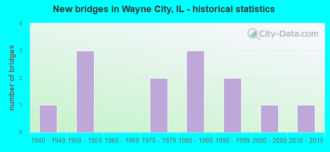
- New bridges - historical statistics
- 11940-1949
- 31950-1959
- 21970-1979
- 31980-1989
- 21990-1999
- 12000-2009
- 12010-2019


- Bridge Condition - Deck
- 58.3%Good
- 33.3%Satisfactory
- 8.3%Poor

- Bridge Condition - Superstructure
- 8.3%Very good
- 25.0%Good
- 50.0%Satisfactory
- 8.3%Fair
- 8.3%Poor

- Bridge Condition - Substructure
- 41.7%Very good
- 16.7%Good
- 25.0%Satisfactory
- 16.7%Fair

- Bridge Condition - Channel
- 23.1%Very good
- 30.8%Good
- 30.8%Satisfactory
- 15.4%Fair
Find on map >> Show street view
Structure Number: 960001, Location: NCL WAYNE CITY (Lat: 38.357975, Lng: -88.588325), Route carried "on" structure: State highway 15, Year Built: 1958, Year Reconstructed: 1997, Status: Open, Structure Length: 4.39m (14.40ft), Average Daily Traffic: 3,200 (year 2021), Truck Traffic: 10%, Average Future Daily Traffic: 3,780 (year 2032), Design Load: HS 20, Features Intersected: SHOE CREEK
Minimum Vertical Clearance: 30+ m (98+ ft), Kilometerpoint: 156.231, Lanes on structure: 2, Base Highway Network: Yes, Owner: State Highway Agency, Approaching Roadway Width: 9.1m (29.9ft), Material/Design: Steel continuous, Design/Construction: Stringer/Multi-beam, Number Of Spans In Main Unit: 3, Length of Maximum Span: 15.8m (51.8ft), Curb-To-Curb Width: 10.8m (35.4ft), Out-to-Out Width: 11.8m (38.7ft)
Condition: Deck: Satisfactory, Superstructure: Satisfactory, Substructure: Good, Channel: Good, Operating Rating: 87.2 metric tons, Method Used To Determine Operating Rating: Load Factor (LF) rating reported by rating factor (RF) method using MS18 loading, Inventory Rating: 52.2 metric tons, Method Used To Determine Inventory Rating: Load Factor (LF) rating reported by rating factor (RF) method using MS18 loading, Structural Evaluation: Equal to present minimum criteria, Deck Geometry: Somewhat better than minimum adequacy, Waterway Adequacy: Equal to present desirable criteria, Approach Roadway Alignment: Equal to present desirable criteria, Designated Inspection Frequency: Every 24 months, Inspection Date: August 2020, Deck Structure Type: Concrete Cast-file-Place, Wearing Surface/Protective System: Deck Protection: Epoxy Coated Reinforcing
Find on map >> Show street view
Structure Number: 960003, Location: .4 MI N WAYNE CITY (Lat: 38.363244, Lng: -88.587956), Route carried "on" structure: State highway 15, Year Built: 1958, Year Reconstructed: 1995, Status: Open, Structure Length: 5.85m (19.19ft), Average Daily Traffic: 3,200 (year 2021), Truck Traffic: 10%, Average Future Daily Traffic: 3,780 (year 2032), Design Load: HS 20, Features Intersected: SKILLET FORK
Minimum Vertical Clearance: 30+ m (98+ ft), Kilometerpoint: 156.810, Lanes on structure: 2, Base Highway Network: Yes, Owner: State Highway Agency, Approaching Roadway Width: 9.1m (29.9ft), Material/Design: Steel continuous, Design/Construction: Stringer/Multi-beam, Number Of Spans In Main Unit: 3, Length of Maximum Span: 21.0m (68.9ft), Curb-To-Curb Width: 11.0m (36.1ft), Out-to-Out Width: 11.9m (39.0ft)
Condition: Deck: Good, Superstructure: Satisfactory, Substructure: Good, Channel: Satisfactory, Operating Rating: 70.3 metric tons, Method Used To Determine Operating Rating: Load Factor (LF) rating reported by rating factor (RF) method using MS18 loading, Inventory Rating: 42.1 metric tons, Method Used To Determine Inventory Rating: Load Factor (LF) rating reported by rating factor (RF) method using MS18 loading, Structural Evaluation: Equal to present minimum criteria, Deck Geometry: Somewhat better than minimum adequacy, Waterway Adequacy: Equal to present desirable criteria, Approach Roadway Alignment: Equal to present desirable criteria, Designated Inspection Frequency: Every 24 months, Underwater Inspection Frequency: Every 24 months, Inspection Date: May 2021, Underwater Inspection Date: March 2021, Deck Structure Type: Concrete Cast-file-Place, Wearing Surface/Protective System: Deck Protection: Epoxy Coated Reinforcing
Find on map >> Show street view
Structure Number: 960004, Location: .6 MI N WAYNE CITY (Lat: 38.367219, Lng: -88.586119), Route carried "on" structure: State highway 15, Year Built: 1958, Year Reconstructed: 1995, Status: Open, Structure Length: 3.49m (11.45ft), Average Daily Traffic: 3,200 (year 2021), Truck Traffic: 10%, Average Future Daily Traffic: 3,780 (year 2032), Design Load: HS 20, Features Intersected: SKILLET FORK OVERFLO
Minimum Vertical Clearance: 30+ m (98+ ft), Kilometerpoint: 157.277, Lanes on structure: 2, Base Highway Network: Yes, Owner: State Highway Agency, Approaching Roadway Width: 9.8m (32.2ft), Material/Design: Steel continuous, Design/Construction: Stringer/Multi-beam, Number Of Spans In Main Unit: 3, Length of Maximum Span: 12.5m (41.0ft), Curb-To-Curb Width: 11.0m (36.1ft), Out-to-Out Width: 11.9m (39.0ft)
Condition: Deck: Good, Superstructure: Satisfactory, Substructure: Satisfactory, Channel: Good, Operating Rating: 75.2 metric tons, Method Used To Determine Operating Rating: Load Factor (LF) rating reported by rating factor (RF) method using MS18 loading, Inventory Rating: 45.4 metric tons, Method Used To Determine Inventory Rating: Load Factor (LF) rating reported by rating factor (RF) method using MS18 loading, Structural Evaluation: Equal to present minimum criteria, Deck Geometry: Somewhat better than minimum adequacy, Waterway Adequacy: Equal to present desirable criteria, Approach Roadway Alignment: Equal to present desirable criteria, Designated Inspection Frequency: Every 24 months, Inspection Date: Febuary 2021, Deck Structure Type: Concrete Cast-file-Place, Wearing Surface/Protective System: Deck Protection: Epoxy Coated Reinforcing
Find on map >> Show street view
Structure Number: 960062, Location: .2 MI N WAYNE CITY (Lat: 38.360314, Lng: -88.588094), Route carried "on" structure: State highway 15, Year Built: 1982, Status: Open, Structure Length: 12.86m (42.19ft), Average Daily Traffic: 3,200 (year 2021), Truck Traffic: 10%, Average Future Daily Traffic: 3,780 (year 2032), Design Load: HS 20, Features Intersected: SKILLET FORK OVERFLO
Minimum Vertical Clearance: 30+ m (98+ ft), Kilometerpoint: 156.488, Lanes on structure: 2, Base Highway Network: Yes, Owner: State Highway Agency, Approaching Roadway Width: 7.9m (25.9ft), Material/Design: Steel continuous, Design/Construction: Stringer/Multi-beam, Number Of Spans In Main Unit: 10, Length of Maximum Span: 14.6m (47.9ft), Curb-To-Curb Width: 10.9m (35.8ft), Out-to-Out Width: 12.0m (39.4ft)
Condition: Deck: Good, Superstructure: Fair, Substructure: Satisfactory, Channel: Very good, Operating Rating: 71.9 metric tons, Method Used To Determine Operating Rating: Load Factor (LF) rating reported by rating factor (RF) method using MS18 loading, Inventory Rating: 43.4 metric tons, Method Used To Determine Inventory Rating: Load Factor (LF) rating reported by rating factor (RF) method using MS18 loading, Structural Evaluation: Somewhat better than minimum adequacy, Deck Geometry: Somewhat better than minimum adequacy, Waterway Adequacy: Equal to present desirable criteria, Approach Roadway Alignment: Equal to present desirable criteria, Designated Inspection Frequency: Every 24 months, Inspection Date: August 2020, Deck Structure Type: Concrete Cast-file-Place, Wearing Surface/Protective System: Deck Protection: Epoxy Coated Reinforcing
Find on map >> Show street view
Structure Number: 960065, Location: 2.5 MI S WAYNE CO (Lat: 38.307419, Lng: -88.588481), Route carried "on" structure: State highway 242, Year Built: 1999, Status: Open, Structure Length: 4.14m (13.58ft), Average Daily Traffic: 1,800 (year 2021), Truck Traffic: 18%, Average Future Daily Traffic: 1,943 (year 2032), Design Load: HS 20, Features Intersected: FOUR MILE CREEK
Minimum Vertical Clearance: 30+ m (98+ ft), Kilometerpoint: 25.701, Lanes on structure: 2, Base Highway Network: Yes, Owner: State Highway Agency, Approaching Roadway Width: 9.1m (29.9ft), Material/Design: Steel continuous, Design/Construction: Stringer/Multi-beam, Number Of Spans In Main Unit: 3, Length of Maximum Span: 15.5m (50.9ft), Curb-To-Curb Width: 9.6m (31.5ft), Out-to-Out Width: 10.6m (34.8ft)
Condition: Deck: Satisfactory, Superstructure: Satisfactory, Substructure: Very good, Channel: Satisfactory, Operating Rating: 89.1 metric tons, Method Used To Determine Operating Rating: Load Factor (LF) rating reported by rating factor (RF) method using MS18 loading, Inventory Rating: 71.0 metric tons, Method Used To Determine Inventory Rating: Load Factor (LF) rating reported by rating factor (RF) method using MS18 loading, Structural Evaluation: Equal to present minimum criteria, Deck Geometry: Somewhat better than minimum adequacy, Waterway Adequacy: Equal to present desirable criteria, Approach Roadway Alignment: Equal to present desirable criteria, Designated Inspection Frequency: Every 24 months, Inspection Date: January 2022, Deck Structure Type: Concrete Cast-file-Place, Wearing Surface/Protective System: Deck Protection: Epoxy Coated Reinforcing
Find on map >> Show street view
Structure Number: 96007, Location: 3.5 MI S WAYNE CITY (Lat: 38.293189, Lng: -88.581336), Route carried "on" structure: State highway 242, Year Built: 2015, Status: Open, Structure Length: 2.29m (7.51ft), Average Daily Traffic: 1,250 (year 2021), Truck Traffic: 30%, Average Future Daily Traffic: 1,400 (year 2024), Design Load: HS 25 or greater, Features Intersected: FISH SLOUGH
Minimum Vertical Clearance: 30+ m (98+ ft), Kilometerpoint: 23.850, Lanes on structure: 2, Base Highway Network: Yes, Owner: State Highway Agency, Approaching Roadway Width: 7.3m (24.0ft), Skew: 3 degrees, Material/Design: Steel, Design/Construction: Stringer/Multi-beam, Number Of Spans In Main Unit: 1, Length of Maximum Span: 21.3m (69.9ft), Curb-To-Curb Width: 7.3m (24.0ft), Out-to-Out Width: 10.7m (35.1ft)
Condition: Deck: Good, Superstructure: Very good, Substructure: Very good, Channel: Very good, Operating Rating: 58.3 metric tons, Method Used To Determine Operating Rating: Load and Resistance Factor Rating (LRFR) rating reported by rating factor(RF) method using HL-93 loadings, Inventory Rating: 44.7 metric tons, Method Used To Determine Inventory Rating: Load and Resistance Factor Rating (LRFR) rating reported by rating factor(RF) method using HL-93 loadings, Structural Evaluation: Equal to present desirable criteria, Deck Geometry: Meets minimum limits, Waterway Adequacy: Equal to present desirable criteria, Approach Roadway Alignment: Equal to present desirable criteria, Designated Inspection Frequency: Every 48 months, Inspection Date: November 2021, Deck Structure Type: Concrete Cast-file-Place, Wearing Surface/Protective System: Deck Protection: Epoxy Coated Reinforcing
Find on map >> Show street view
Structure Number: 962009, Location: N OF WAYNE CITY (Lat: 38.372206, Lng: -88.581697), Route carried "on" structure: County highway , Year Built: 2007, Status: Open, Structure Length: 0.72m (2.36ft), Average Daily Traffic: 175 (year 2017), Truck Traffic: 4%, Average Future Daily Traffic: 184 (year 2032), Design Load: HS 20, Features Intersected: STREAM, Facility Carried by Structure: SBI-15 (OLD RT. 15
Minimum Vertical Clearance: 30+ m (98+ ft), Kilometerpoint: 0.257, Lanes on structure: 2, Owner: State Highway Agency, Approaching Roadway Width: 5.5m (18.0ft), Material/Design: Concrete, Design/Construction: Culvert, Number Of Spans In Main Unit: 2, Length of Maximum Span: 3.3m (10.8ft)
Condition: Channel: Very good, Culverts: Very good, Operating Rating: 44.1 metric tons, Method Used To Determine Operating Rating: Load Factor (LF) rating reported by rating factor (RF) method using MS18 loading, Inventory Rating: 32.4 metric tons, Method Used To Determine Inventory Rating: Load Factor (LF) rating reported by rating factor (RF) method using MS18 loading, Structural Evaluation: Equal to present desirable criteria, Waterway Adequacy: Equal to present desirable criteria, Approach Roadway Alignment: Equal to present desirable criteria, Designated Inspection Frequency: Every 48 months, Inspection Date: July 2018
Find on map >> Show street view
Structure Number: 963072, Location: 1.5 MI SE KEENES (Lat: 38.320700, Lng: -88.626111), Route carried "on" structure: County highway , Year Built: 1945, Status: Open, Structure Length: 1.49m (4.89ft), Average Daily Traffic: 50 (year 2017), Truck Traffic: 8%, Average Future Daily Traffic: 11 (year 2032), Features Intersected: FOUR MILE CREEK, Facility Carried by Structure: TR-126
Minimum Vertical Clearance: 30+ m (98+ ft), Kilometerpoint: 0.740, Lanes on structure: 1, Owner: Town or Township Highway Agency, Approaching Roadway Width: 4.6m (15.1ft), Material/Design: Steel continuous, Design/Construction: Stringer/Multi-beam, Number Of Spans In Main Unit: 2, Length of Maximum Span: 7.3m (24.0ft), Curb-To-Curb Width: 4.8m (15.7ft), Out-to-Out Width: 4.8m (15.7ft)
Condition: Deck: Satisfactory, Superstructure: Satisfactory, Substructure: Fair, Channel: Fair, Operating Rating: 38.9 metric tons, Method Used To Determine Operating Rating: Allowable Stress (AS) rating reported by rating factor (RF) method using MS18 loading, Inventory Rating: 24.3 metric tons, Method Used To Determine Inventory Rating: Allowable Stress (AS) rating reported by rating factor (RF) method using MS18 loading, Structural Evaluation: Somewhat better than minimum adequacy, Deck Geometry: Equal to present desirable criteria, Waterway Adequacy: Somewhat better than minimum adequacy, Approach Roadway Alignment: Meets minimum limits, Designated Inspection Frequency: Every 24 months, Inspection Date: January 2021, Deck Structure Type: Concrete Cast-file-Place
Find on map >> Show street view
Structure Number: 963319, Location: 2MI SW OF WAYNE CITY (Lat: 38.312597, Lng: -88.609772), Route carried "on" structure: County highway , Year Built: 1979, Status: Open, Structure Length: 3.11m (10.20ft), Average Daily Traffic: 125 (year 2017), Truck Traffic: 8%, Average Future Daily Traffic: 131 (year 2032), Design Load: HS 20, Features Intersected: FOUR MILE CREEK, Facility Carried by Structure: TR-589
Minimum Vertical Clearance: 30+ m (98+ ft), Kilometerpoint: 3.058, Lanes on structure: 2, Owner: Town or Township Highway Agency, Approaching Roadway Width: 5.5m (18.0ft), Material/Design: Prestressed concrete, Design/Construction: Box Beam or Girders - Multiple, Number Of Spans In Main Unit: 3, Length of Maximum Span: 13.4m (44.0ft), Curb-To-Curb Width: 7.4m (24.3ft), Out-to-Out Width: 7.4m (24.3ft)
Condition: Deck: Poor, Superstructure: Poor, Substructure: Satisfactory, Channel: Satisfactory, Operating Rating: 52.5 metric tons, Method Used To Determine Operating Rating: Load Factor (LF) rating reported by rating factor (RF) method using MS18 loading, Inventory Rating: 31.4 metric tons, Method Used To Determine Inventory Rating: Load Factor (LF) rating reported by rating factor (RF) method using MS18 loading, Structural Evaluation: Meets minimum limits, Deck Geometry: Somewhat better than minimum adequacy, Waterway Adequacy: Equal to present minimum criteria, Approach Roadway Alignment: Equal to present desirable criteria, Designated Inspection Frequency: Every 24 months, Inspection Date: January 2021, Deck Structure Type: Concrete Precast Panels, Wearing Surface/Protective System: Wearing Surface: Gravel
Find on map >> Show street view
Structure Number: 963321, Location: 1 MI E WAYNE CITY (Lat: 38.342342, Lng: -88.559497), Route carried "on" structure: County highway , Year Built: 1979, Status: Open, Structure Length: 5.18m (16.99ft), Average Daily Traffic: 325 (year 2017), Truck Traffic: 8%, Average Future Daily Traffic: 315 (year 2032), Design Load: HS 20, Features Intersected: SKILLET FORK, Facility Carried by Structure: TR-533
Minimum Vertical Clearance: 30+ m (98+ ft), Kilometerpoint: 1.255, Lanes on structure: 2, Owner: Town or Township Highway Agency, Approaching Roadway Width: 6.1m (20.0ft), Skew: 3 degrees, Material/Design: Prestressed concrete, Design/Construction: Box Beam or Girders - Multiple, Number Of Spans In Main Unit: 4, Length of Maximum Span: 12.8m (42.0ft), Curb-To-Curb Width: 7.3m (24.0ft), Out-to-Out Width: 7.4m (24.3ft)
Condition: Deck: Good, Superstructure: Good, Substructure: Fair, Channel: Fair, Operating Rating: 69.0 metric tons, Method Used To Determine Operating Rating: Load Factor (LF) rating reported by rating factor (RF) method using MS18 loading, Inventory Rating: 41.5 metric tons, Method Used To Determine Inventory Rating: Load Factor (LF) rating reported by rating factor (RF) method using MS18 loading, Structural Evaluation: Somewhat better than minimum adequacy, Deck Geometry: Somewhat better than minimum adequacy, Waterway Adequacy: Equal to present minimum criteria, Approach Roadway Alignment: Better than present minimum criteria, Designated Inspection Frequency: Every 24 months, Inspection Date: January 2021, Deck Structure Type: Concrete Precast Panels, Wearing Surface/Protective System: Wearing Surface: Gravel
Find on map >> Show street view
Structure Number: 963344, Location: 3 MI S WAYNE CITY (Lat: 38.297786, Lng: -88.580944), Route carried "on" structure: County highway , Year Built: 1984, Status: Open, Structure Length: 1.86m (6.10ft), Average Daily Traffic: 200 (year 2017), Truck Traffic: 15%, Average Future Daily Traffic: 131 (year 2032), Design Load: HS 20, Features Intersected: FISH SLOUGH CREEK, Facility Carried by Structure: TR-615
Minimum Vertical Clearance: 30+ m (98+ ft), Kilometerpoint: 4.136, Lanes on structure: 2, Owner: Town or Township Highway Agency, Approaching Roadway Width: 6.7m (22.0ft), Material/Design: Prestressed concrete, Design/Construction: Box Beam or Girders - Multiple, Number Of Spans In Main Unit: 1, Length of Maximum Span: 18.0m (59.1ft), Curb-To-Curb Width: 8.6m (28.2ft), Out-to-Out Width: 8.6m (28.2ft)
Condition: Deck: Good, Superstructure: Good, Substructure: Very good, Channel: Good, Operating Rating: 44.4 metric tons, Method Used To Determine Operating Rating: Assigned rating based on Load Factor Design (LFD) reported by rating factor (RF) using MS18 loading, Inventory Rating: 32.4 metric tons, Method Used To Determine Inventory Rating: Assigned rating based on Load Factor Design (LFD) reported by rating factor (RF) using MS18 loading, Structural Evaluation: Better than present minimum criteria, Deck Geometry: Equal to present minimum criteria, Waterway Adequacy: Equal to present desirable criteria, Approach Roadway Alignment: Equal to present desirable criteria, Designated Inspection Frequency: Every 48 months, Inspection Date: January 2019, Deck Structure Type: Concrete Precast Panels, Wearing Surface/Protective System: Wearing Surface: Gravel
Find on map >> Show street view
Structure Number: 963356, Location: 2.5 MI N WAYNE CITY (Lat: 38.394369, Lng: -88.587494), Route carried "on" structure: County highway , Year Built: 1987, Status: Open, Structure Length: 1.28m (4.20ft), Average Daily Traffic: 450 (year 2017), Truck Traffic: 9%, Average Future Daily Traffic: 473 (year 2032), Design Load: HS 20, Features Intersected: TRIB SKILLET FORK, Facility Carried by Structure: FAS-2819 (CH-12)
Minimum Vertical Clearance: 30+ m (98+ ft), Kilometerpoint: 12.939, Lanes on structure: 2, Owner: County Highway Agency, Approaching Roadway Width: 6.4m (21.0ft), Material/Design: Prestressed concrete, Design/Construction: Box Beam or Girders - Multiple, Number Of Spans In Main Unit: 1, Length of Maximum Span: 11.9m (39.0ft), Curb-To-Curb Width: 8.6m (28.2ft), Out-to-Out Width: 8.6m (28.2ft)
Condition: Deck: Good, Superstructure: Good, Substructure: Very good, Channel: Satisfactory, Operating Rating: 44.4 metric tons, Method Used To Determine Operating Rating: Assigned rating based on Load Factor Design (LFD) reported by rating factor (RF) using MS18 loading, Inventory Rating: 32.4 metric tons, Method Used To Determine Inventory Rating: Assigned rating based on Load Factor Design (LFD) reported by rating factor (RF) using MS18 loading, Structural Evaluation: Better than present minimum criteria, Deck Geometry: Somewhat better than minimum adequacy, Waterway Adequacy: Equal to present desirable criteria, Approach Roadway Alignment: Equal to present desirable criteria, Designated Inspection Frequency: Every 48 months, Inspection Date: Febuary 2019, Deck Structure Type: Concrete Precast Panels, Wearing Surface/Protective System: Wearing Surface: Gravel
Find on map >> Show street view
Structure Number: 963401, Location: 2 MI NW WAYNE CITY (Lat: 38.387864, Lng: -88.614067), Route carried "on" structure: County highway , Year Built: 1997, Status: Open, Structure Length: 5.24m (17.19ft), Average Daily Traffic: 100 (year 2017), Truck Traffic: 10%, Average Future Daily Traffic: 105 (year 2032), Design Load: HS 20, Features Intersected: SKILLET FORK, Facility Carried by Structure: TR-443
Minimum Vertical Clearance: 30+ m (98+ ft), Kilometerpoint: 2.655, Lanes on structure: 2, Owner: Town or Township Highway Agency, Approaching Roadway Width: 8.2m (26.9ft), Skew: 3 degrees, Material/Design: Prestressed concrete, Design/Construction: Box Beam or Girders - Multiple, Number Of Spans In Main Unit: 3, Length of Maximum Span: 17.3m (56.8ft), Curb-To-Curb Width: 8.2m (26.9ft), Out-to-Out Width: 8.2m (26.9ft)
Condition: Deck: Satisfactory, Superstructure: Satisfactory, Substructure: Very good, Channel: Good, Operating Rating: 44.1 metric tons, Method Used To Determine Operating Rating: Assigned rating based on Load Factor Design (LFD) reported by rating factor (RF) using MS18 loading, Inventory Rating: 32.4 metric tons, Method Used To Determine Inventory Rating: Assigned rating based on Load Factor Design (LFD) reported by rating factor (RF) using MS18 loading, Structural Evaluation: Equal to present minimum criteria, Deck Geometry: Equal to present minimum criteria, Waterway Adequacy: Equal to present minimum criteria, Approach Roadway Alignment: Equal to present minimum criteria, Designated Inspection Frequency: Every 24 months, Inspection Date: January 2021, Deck Structure Type: Concrete Precast Panels