Bridge Statistics for Waynesville, Missouri (MO)
Condition, Traffic, Stress, Structural Evaluation, Project Costs
- National Bridge Inventory (NBI) Statistics
- 27Number of bridges
- 486ft / 148mTotal length
- $8,773,000Total costs
- 241,526Total average daily traffic
- 54,797Total average daily truck traffic
- National Bridge Inventory (NBI) Registered Bridges for Waynesville
- No street view available for this location
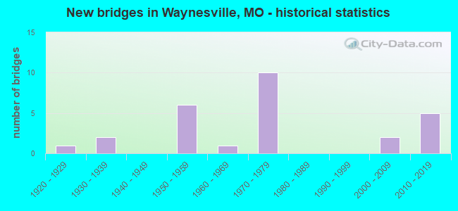
- New bridges - historical statistics
- 11920-1929
- 21930-1939
- 61950-1959
- 11960-1969
- 101970-1979
- 22000-2009
- 52010-2019

- Reconstructed bridges - Historical Statistics
- 11930-1939
- 01940-1949
- 01950-1959
- 01960-1969
- 11970-1979
- 11980-1989
- 11990-1999
- 12000-2009


- Bridge Condition - Deck
- 14.3%Very good
- 28.6%Good
- 42.9%Satisfactory
- 7.1%Fair
- 7.1%Serious

- Bridge Condition - Superstructure
- 14.3%Very good
- 14.3%Good
- 42.9%Satisfactory
- 28.6%Fair

- Bridge Condition - Substructure
- 21.4%Excellent
- 35.7%Good
- 7.1%Satisfactory
- 28.6%Fair
- 7.1%Poor

- Bridge Condition - Channel
- 6.7%Very good
- 20.0%Good
- 40.0%Satisfactory
- 26.7%Fair
- 6.7%Poor

- Bridge Condition - Culverts
- 20.0%Good
- 60.0%Satisfactory
- 20.0%Fair
Find on map >> Show street view
Structure Number: 1044, Location: S 35 T 36 N R 12 W (Lat: 37.812325, Lng: -92.223464), Route carried "on" structure: State highway H, Year Built: 1979, Status: Open, Structure Length: 0.96m (3.15ft), Average Daily Traffic: 14,329 (year 2021), Truck Traffic: 23%, Average Future Daily Traffic: 21,494 (year 2041), Design Load: H 20, Features Intersected: BR BRADFORD CR
Minimum Vertical Clearance: 30+ m (98+ ft), Kilometerpoint: 0.106, Lanes on structure: 2, Owner: State Highway Agency, Approaching Roadway Width: 11.0m (36.1ft), Material/Design: Concrete continuous, Design/Construction: Culvert, Number Of Spans In Main Unit: 3, Length of Maximum Span: 3.0m (9.8ft)
Condition: Channel: Very good, Culverts: Satisfactory, Operating Rating: 93.6 metric tons, Method Used To Determine Operating Rating: Load Factor (LF), Inventory Rating: 55.8 metric tons, Method Used To Determine Inventory Rating: Load Factor (LF), Structural Evaluation: Equal to present minimum criteria, Waterway Adequacy: Equal to present desirable criteria, Approach Roadway Alignment: Equal to present desirable criteria, Designated Inspection Frequency: Every 24 months, Inspection Date: October 2021
Find on map >> Show street view
Structure Number: 16757, Location: S 21 T 36 N R 12 W (Lat: 37.831528, Lng: -92.247689), Route carried "on" structure: County highway 131, Year Built: 1937, Status: Posted for load, Structure Length: 0.73m (2.40ft), Average Daily Traffic: 75 (year 2020), Truck Traffic: 10%, Average Future Daily Traffic: 98 (year 2040), Features Intersected: BR GASCONADE RVR, Facility Carried by Structure: REPORTER RD
Minimum Vertical Clearance: 30+ m (98+ ft), Kilometerpoint: 1.770, Lanes on structure: 2, Owner: County Highway Agency, Approaching Roadway Width: 4.9m (16.1ft), Material/Design: Concrete, Design/Construction: Stringer/Multi-beam, Number Of Spans In Main Unit: 1, Length of Maximum Span: 7.0m (23.0ft), Curb-To-Curb Width: 6.0m (19.7ft), Out-to-Out Width: 6.9m (22.6ft)
Condition: Deck: Satisfactory, Superstructure: Satisfactory, Substructure: Fair, Channel: Fair, Operating Rating: 24.3 metric tons, Method Used To Determine Operating Rating: Load Factor (LF), Inventory Rating: 12.6 metric tons, Method Used To Determine Inventory Rating: Load Factor (LF), Structural Evaluation: Meets minimum limits, Deck Geometry: Meets minimum limits, Waterway Adequacy: Better than present minimum criteria, Approach Roadway Alignment: Equal to present desirable criteria, Bridge Posting: Required (Relationship of Operating Rating to Maximum Legal Load: 0.1 - 9.9% below), Designated Inspection Frequency: Every 24 months, Inspection Date: January 2022, Deck Structure Type: Concrete Cast-file-Place, Wearing Surface/Protective System: Wearing Surface: Monolithic Concrete
Find on map >> Show street view
Structure Number: 2514, Location: S 7 T 36 N R 12 W (Lat: 37.867008, Lng: -92.291022), Route carried "on" structure: State highway T, Year Built: 1973, Status: Open, Structure Length: 24.29m (79.69ft), Average Daily Traffic: 4,966 (year 2021), Truck Traffic: 4%, Average Future Daily Traffic: 7,449 (year 2041), Design Load: H 15, Features Intersected: GASCONADE RVR
Minimum Vertical Clearance: 30+ m (98+ ft), Kilometerpoint: 7.707, Lanes on structure: 2, Owner: State Highway Agency, Approaching Roadway Width: 6.7m (22.0ft), Material/Design: Steel continuous, Design/Construction: Stringer/Multi-beam, Number Of Spans In Main Unit: 2, Number Of Approach Spans: 14, Length of Maximum Span: 27.6m (90.6ft), Curb-To-Curb Width: 8.5m (27.9ft), Out-to-Out Width: 9.4m (30.8ft)
Condition: Deck: Serious, Superstructure: Satisfactory, Substructure: Fair, Channel: Satisfactory, Operating Rating: 29.7 metric tons, Method Used To Determine Operating Rating: Allowable Stress (AS), Inventory Rating: 17.1 metric tons, Method Used To Determine Inventory Rating: Allowable Stress (AS), Structural Evaluation: Meets minimum limits, Deck Geometry: Meets minimum limits, Waterway Adequacy: Equal to present minimum criteria, Approach Roadway Alignment: Equal to present desirable criteria, Length Of Structure Improvement: 2.43m (7.97ft), Designated Inspection Frequency: Every 24 months, Other Special Inspection Frequency: Every 24 months, Inspection Date: June 2021, Other Special Inspection Date: June 2021, Bridge Improvement Cost: $3,060,000, Roadway Improvement Cost: $306,000, Total Project Cost: $4,590,000 ( Estimate for 2022), Deck Structure Type: Concrete Cast-file-Place, Wearing Surface/Protective System: Wearing Surface: Latex Concrete
Find on map >> Show street view
Structure Number: 2619, Location: S 12 T 35 N R 13 W (Lat: 37.778597, Lng: -92.318692), Route carried "on" structure: State highway 7, Year Built: 1977, Status: Open, Structure Length: 6.80m (22.31ft), Average Daily Traffic: 2,139 (year 2021), Truck Traffic: 9%, Average Future Daily Traffic: 3,422 (year 2041), Design Load: H 20, Features Intersected: IS 44
Minimum Vertical Clearance: 30+ m (98+ ft), Kilometerpoint: 300.370, Lanes on structure: 2, Lanes under structure: 4, Base Highway Network: Yes, Owner: State Highway Agency, Approaching Roadway Width: 13.4m (44.0ft), Material/Design: Steel continuous, Design/Construction: Stringer/Multi-beam, Number Of Spans In Main Unit: 2, Number Of Approach Spans: 2, Length of Maximum Span: 23.2m (76.1ft), Curb or Sidewalk Widths: Left: 0.2m (0.7ft), Right: 0.2m (0.7ft), Curb-To-Curb Width: 13.4m (44.0ft), Out-to-Out Width: 14.3m (46.9ft)
Condition: Deck: Good, Superstructure: Fair, Substructure: Good, Operating Rating: 39.6 metric tons, Method Used To Determine Operating Rating: Load Factor (LF), Inventory Rating: 23.4 metric tons, Method Used To Determine Inventory Rating: Load Factor (LF), Structural Evaluation: Somewhat better than minimum adequacy, Deck Geometry: Better than present minimum criteria, Underclear: Equal to present minimum criteria, Approach Roadway Alignment: Equal to present desirable criteria, Designated Inspection Frequency: Every 24 months, Other Special Inspection Frequency: Every 24 months, Inspection Date: June 2021, Other Special Inspection Date: June 2021, Deck Structure Type: Concrete Cast-file-Place, Wearing Surface/Protective System: Wearing Surface: Bituminous, Deck Protection: Epoxy Coated Reinforcing
Find on map >> Show street view
Structure Number: 262, Location: S 35 T 36 N R 12 W (Lat: 37.804536, Lng: -92.221825), Route carried "on" structure: State highway H, Year Built: 1979, Year Reconstructed: 2003, Status: Open, Structure Length: 7.80m (25.59ft), Average Daily Traffic: 10,963 (year 2021), Truck Traffic: 23%, Average Future Daily Traffic: 16,445 (year 2041), Design Load: H 20, Features Intersected: IS 44
Minimum Vertical Clearance: 30+ m (98+ ft), Kilometerpoint: 0.964, Lanes on structure: 5, Lanes under structure: 4, Owner: State Highway Agency, Approaching Roadway Width: 18.3m (60.0ft), Skew: 1 degrees, Material/Design: Steel continuous, Design/Construction: Stringer/Multi-beam, Number Of Spans In Main Unit: 4, Length of Maximum Span: 26.5m (86.9ft), Curb-To-Curb Width: 24.4m (80.1ft), Out-to-Out Width: 25.2m (82.7ft)
Condition: Deck: Good, Superstructure: Good, Substructure: Good, Operating Rating: 43.2 metric tons, Method Used To Determine Operating Rating: Load Factor (LF), Inventory Rating: 26.1 metric tons, Method Used To Determine Inventory Rating: Load Factor (LF), Structural Evaluation: Equal to present minimum criteria, Deck Geometry: Superior to present desirable criteria, Underclear: Somewhat better than minimum adequacy, Approach Roadway Alignment: Equal to present desirable criteria, Designated Inspection Frequency: Every 24 months, Other Special Inspection Frequency: Every 24 months, Inspection Date: June 2021, Other Special Inspection Date: June 2021, Deck Structure Type: Concrete Cast-file-Place, Wearing Surface/Protective System: Wearing Surface: Epoxy Overlay, Deck Protection: Epoxy Coated Reinforcing
Find on map >> Show street view
Structure Number: 2621, Location: S 25 T 36 N R 12 W (Lat: 37.817469, Lng: -92.193567), Route carried "on" structure: Interstate 44, Year Built: 1979, Year Reconstructed: 2008, Status: Open, Structure Length: 22.71m (74.51ft), Average Daily Traffic: 17,715 (year 2021), Truck Traffic: 30%, Average Future Daily Traffic: 33,659 (year 2041), Design Load: HS 20+Mod, Features Intersected: CRD SUPERIOR RD, ROUBIDO
Minimum Vertical Clearance: 30+ m (98+ ft), Kilometerpoint: 254.571, Lanes on structure: 2, Lanes under structure: 2, Base Highway Network: Yes, Owner: State Highway Agency, Approaching Roadway Width: 12.2m (40.0ft), Skew: 3 degrees, Material/Design: Steel continuous, Design/Construction: Stringer/Multi-beam, Number Of Spans In Main Unit: 4, Number Of Approach Spans: 6, Length of Maximum Span: 30.5m (100.1ft), Curb-To-Curb Width: 12.0m (39.4ft), Out-to-Out Width: 12.9m (42.3ft)
Condition: Deck: Satisfactory, Superstructure: Fair, Substructure: Good, Channel: Satisfactory, Operating Rating: 57.6 metric tons, Method Used To Determine Operating Rating: Load Factor (LF), Inventory Rating: 35.1 metric tons, Method Used To Determine Inventory Rating: Load Factor (LF), Structural Evaluation: Somewhat better than minimum adequacy, Deck Geometry: Equal to present minimum criteria, Underclear: Equal to present minimum criteria, Waterway Adequacy: Equal to present desirable criteria, Approach Roadway Alignment: Equal to present desirable criteria, Designated Inspection Frequency: Every 24 months, Inspection Date: March 2020, Deck Structure Type: Concrete Cast-file-Place, Wearing Surface/Protective System: Wearing Surface: Epoxy Overlay, Deck Protection: Epoxy Coated Reinforcing
Find on map >> Show street view
Structure Number: 29312, Location: S 28 T 36 N R 12 W (Lat: 37.820136, Lng: -92.254550), Route carried "on" structure: State highway T, Year Built: 2002, Status: Open, Structure Length: 1.43m (4.69ft), Average Daily Traffic: 4,966 (year 2021), Truck Traffic: 4%, Average Future Daily Traffic: 7,449 (year 2041), Design Load: HS 20, Features Intersected: TOWER HOLO
Minimum Vertical Clearance: 30+ m (98+ ft), Kilometerpoint: 14.730, Lanes on structure: 2, Owner: State Highway Agency, Approaching Roadway Width: 8.5m (27.9ft), Skew: 1 degrees, Material/Design: Concrete continuous, Design/Construction: Culvert, Number Of Spans In Main Unit: 3, Length of Maximum Span: 4.9m (16.1ft)
Condition: Channel: Fair, Culverts: Fair, Operating Rating: 87.3 metric tons, Method Used To Determine Operating Rating: Field evaluation and documented engineering judgment, Inventory Rating: 52.2 metric tons, Method Used To Determine Inventory Rating: Field evaluation and documented engineering judgment, Structural Evaluation: Somewhat better than minimum adequacy, Waterway Adequacy: Superior to present desirable criteria, Approach Roadway Alignment: Equal to present desirable criteria, Designated Inspection Frequency: Every 24 months, Inspection Date: October 2021
Find on map >> Show street view
Structure Number: 29338, Location: S 35 T 36 N R 12 W (Lat: 37.801883, Lng: -92.220122), Route carried "on" structure: State highway H, Year Built: 2003, Status: Open, Structure Length: 1.52m (4.99ft), Average Daily Traffic: 7,742 (year 2021), Truck Traffic: 5%, Average Future Daily Traffic: 11,613 (year 2041), Design Load: HS 20+Mod, Features Intersected: BRADFORD HOLLOW
Minimum Vertical Clearance: 30+ m (98+ ft), Kilometerpoint: 1.333, Lanes on structure: 4, Owner: State Highway Agency, Approaching Roadway Width: 9.8m (32.2ft), Skew: 3 degrees, Material/Design: Concrete, Design/Construction: Culvert, Number Of Spans In Main Unit: 3, Length of Maximum Span: 4.9m (16.1ft), Curb-To-Curb Width: 9.9m (32.5ft), Out-to-Out Width: 10.5m (34.4ft)
Condition: Channel: Good, Culverts: Satisfactory, Inventory Rating: 98.1 metric tons, Method Used To Determine Inventory Rating: Load Factor (LF), Structural Evaluation: Equal to present minimum criteria, Deck Geometry: High priority of replacement, Waterway Adequacy: Superior to present desirable criteria, Approach Roadway Alignment: Equal to present desirable criteria, Length Of Structure Improvement: 0.22m (0.72ft), Designated Inspection Frequency: Every 24 months, Inspection Date: October 2021, Bridge Improvement Cost: $170,000, Roadway Improvement Cost: $17,000, Total Project Cost: $255,000 ( Estimate for 2022)
Find on map >> Show street view
Structure Number: 31058, Location: S 25 T 36 N R 12 W (Lat: 37.821267, Lng: -92.210181), Route carried "on" structure: City street 4485, Year Built: 1960, Status: Closed, Structure Length: 0.96m (3.15ft), Average Daily Traffic: 5 (year 2020), Truck Traffic: 1%, Average Future Daily Traffic: 7 (year 2040), Design Load: HS 20, Features Intersected: MITCHEL CR, Facility Carried by Structure: GLENDA ST
Minimum Vertical Clearance: 30+ m (98+ ft), Kilometerpoint: 0.000, Lanes on structure: 1, Owner: City or Municipal Highway Agency, Approaching Roadway Width: 4.0m (13.1ft), Material/Design: Steel, Design/Construction: Stringer/Multi-beam, Number Of Spans In Main Unit: 1, Length of Maximum Span: 9.1m (29.9ft), Curb-To-Curb Width: 3.3m (10.8ft), Out-to-Out Width: 3.8m (12.5ft)
Condition: Deck: Fair, Superstructure: Fair, Substructure: Poor, Channel: Poor, Waterway Adequacy: Better than present minimum criteria, Approach Roadway Alignment: Meets minimum limits, Bridge Posting: Required (Relationship of Operating Rating to Maximum Legal Load: > 39.9% below), Length Of Structure Improvement: 0.16m (0.52ft), Designated Inspection Frequency: Every 24 months, Inspection Date: January 2018, Bridge Improvement Cost: $115,000, Roadway Improvement Cost: $12,000, Total Project Cost: $173,000 ( Estimate for 2022), Deck Structure Type: Wood or Timber, Wearing Surface/Protective System: Wearing Surface: Wood or Timber
Find on map >> Show street view
Structure Number: 32623, Location: S 14 T 36 N R 12 W (Lat: 37.851053, Lng: -92.214078), Route carried "on" structure: State highway 17, Year Built: 2010, Status: Open, Structure Length: 15.00m (49.21ft), Average Daily Traffic: 6,281 (year 2021), Truck Traffic: 7%, Average Future Daily Traffic: 10,050 (year 2041), Features Intersected: GASCONADE RVR
Minimum Vertical Clearance: 30+ m (98+ ft), Kilometerpoint: 73.610, Lanes on structure: 2, Base Highway Network: Yes, Owner: State Highway Agency, Approaching Roadway Width: 8.5m (27.9ft), Skew: 1 degrees, Material/Design: Prestressed concrete continuous, Design/Construction: Tee Beam, Number Of Spans In Main Unit: 4, Length of Maximum Span: 38.1m (125.0ft), Curb-To-Curb Width: 8.5m (27.9ft), Out-to-Out Width: 9.3m (30.5ft)
Condition: Deck: Good, Superstructure: Good, Substructure: Excellent, Channel: Satisfactory, Operating Rating: 81.9 metric tons, Method Used To Determine Operating Rating: Load Factor (LF), Inventory Rating: 49.5 metric tons, Method Used To Determine Inventory Rating: Load Factor (LF), Structural Evaluation: Better than present minimum criteria, Deck Geometry: Meets minimum limits, Waterway Adequacy: Superior to present desirable criteria, Approach Roadway Alignment: Equal to present desirable criteria, Designated Inspection Frequency: Every 24 months, Underwater Inspection Frequency: Every 60 months, Inspection Date: October 2021, Underwater Inspection Date: June 2019, Deck Structure Type: Concrete Cast-file-Place, Wearing Surface/Protective System: Wearing Surface: Monolithic Concrete, Deck Protection: Epoxy Coated Reinforcing
Find on map >> Show street view
Structure Number: 32625, Location: S 14 T 36 N R 12 W (Lat: 37.849850, Lng: -92.219564), Route carried "on" structure: State highway 17, Year Built: 2010, Status: Open, Structure Length: 6.16m (20.21ft), Average Daily Traffic: 6,281 (year 2021), Truck Traffic: 7%, Average Future Daily Traffic: 10,050 (year 2041), Features Intersected: GASCONADE RVR OVRF
Minimum Vertical Clearance: 30+ m (98+ ft), Kilometerpoint: 73.150, Lanes on structure: 2, Base Highway Network: Yes, Owner: State Highway Agency, Approaching Roadway Width: 7.9m (25.9ft), Skew: 4 degrees, Material/Design: Prestressed concrete continuous, Design/Construction: Tee Beam, Number Of Spans In Main Unit: 3, Length of Maximum Span: 21.6m (70.9ft), Curb-To-Curb Width: 7.9m (25.9ft), Out-to-Out Width: 8.7m (28.5ft)
Condition: Deck: Very good, Superstructure: Very good, Substructure: Excellent, Channel: Satisfactory, Operating Rating: 60.3 metric tons, Method Used To Determine Operating Rating: Load Factor (LF), Inventory Rating: 36.0 metric tons, Method Used To Determine Inventory Rating: Load Factor (LF), Structural Evaluation: Equal to present desirable criteria, Deck Geometry: High priority of corrective action, Waterway Adequacy: Superior to present desirable criteria, Approach Roadway Alignment: Equal to present desirable criteria, Length Of Structure Improvement: 0.72m (2.36ft), Designated Inspection Frequency: Every 24 months, Inspection Date: October 2021, Bridge Improvement Cost: $616,000, Roadway Improvement Cost: $62,000, Total Project Cost: $924,000 ( Estimate for 2022), Deck Structure Type: Concrete Cast-file-Place, Wearing Surface/Protective System: Wearing Surface: Monolithic Concrete, Deck Protection: Epoxy Coated Reinforcing
Find on map >> Show street view
Structure Number: 32627, Location: S 14 T 36 N R 12 W (Lat: 37.850264, Lng: -92.216556), Route carried "on" structure: State highway 17, Year Built: 2010, Status: Open, Structure Length: 8.20m (26.90ft), Average Daily Traffic: 6,281 (year 2021), Truck Traffic: 7%, Average Future Daily Traffic: 10,050 (year 2041), Features Intersected: GASCONADE RVR OVRF
Minimum Vertical Clearance: 30+ m (98+ ft), Kilometerpoint: 73.409, Lanes on structure: 2, Base Highway Network: Yes, Owner: State Highway Agency, Approaching Roadway Width: 7.9m (25.9ft), Skew: 1 degrees, Material/Design: Prestressed concrete continuous, Design/Construction: Tee Beam, Number Of Spans In Main Unit: 3, Length of Maximum Span: 28.3m (92.8ft), Curb-To-Curb Width: 7.9m (25.9ft), Out-to-Out Width: 8.7m (28.5ft)
Condition: Deck: Very good, Superstructure: Very good, Substructure: Excellent, Channel: Good, Operating Rating: 78.3 metric tons, Method Used To Determine Operating Rating: Load Factor (LF), Inventory Rating: 46.8 metric tons, Method Used To Determine Inventory Rating: Load Factor (LF), Structural Evaluation: Equal to present desirable criteria, Deck Geometry: High priority of corrective action, Waterway Adequacy: Superior to present desirable criteria, Approach Roadway Alignment: Equal to present desirable criteria, Length Of Structure Improvement: 0.92m (3.02ft), Designated Inspection Frequency: Every 24 months, Inspection Date: October 2021, Bridge Improvement Cost: $788,000, Roadway Improvement Cost: $79,000, Total Project Cost: $1,183,000 ( Estimate for 2022), Deck Structure Type: Concrete Cast-file-Place, Wearing Surface/Protective System: Wearing Surface: Monolithic Concrete, Deck Protection: Epoxy Coated Reinforcing
Find on map >> Show street view
Structure Number: 33692, Location: S 8 T 48 N R 32 W (Lat: 39.002472, Lng: -94.484189), Route carried "on" structure: City street , Year Built: 2011, Status: Open, Structure Length: 7.16m (23.49ft), Average Daily Traffic: 3,724 (year 2021), Truck Traffic: 5%, Average Future Daily Traffic: 5,214 (year 2041), Design Load: HS 20+Mod, Features Intersected: MO 350, Facility Carried by Structure: E 67TH ST E
Minimum Vertical Clearance: 30+ m (98+ ft), Kilometerpoint: 2.364, Lanes on structure: 2, Lanes under structure: 5, Owner: State Highway Agency, Approaching Roadway Width: 11.0m (36.1ft), Skew: 4 degrees, Material/Design: Prestressed concrete, Design/Construction: Box Beam or Girders - Multiple, Number Of Spans In Main Unit: 1, Number Of Approach Spans: 3, Length of Maximum Span: 25.9m (85.0ft), Curb-To-Curb Width: 11.0m (36.1ft), Out-to-Out Width: 11.6m (38.1ft)
Condition: Deck: Satisfactory, Superstructure: Satisfactory, Substructure: Good, Operating Rating: 84.6 metric tons, Method Used To Determine Operating Rating: Load Factor (LF), Inventory Rating: 37.8 metric tons, Method Used To Determine Inventory Rating: Load Factor (LF), Structural Evaluation: Equal to present minimum criteria, Deck Geometry: Somewhat better than minimum adequacy, Underclear: High priority of corrective action, Approach Roadway Alignment: Equal to present desirable criteria, Designated Inspection Frequency: Every 24 months, Inspection Date: September 2021, Deck Structure Type: Concrete Cast-file-Place, Wearing Surface/Protective System: Wearing Surface: Monolithic Concrete, Deck Protection: Epoxy Coated Reinforcing
Find on map >> Show street view
Structure Number: 34603, Location: S 35 T 36 N R 12 W (Lat: 37.815389, Lng: -92.218194), Route carried "on" structure: City street , Year Built: 2013, Status: Open, Structure Length: 1.10m (3.61ft), Average Daily Traffic: 100 (year 2020), Truck Traffic: 10%, Average Future Daily Traffic: 145 (year 2040), Design Load: HS 20, Features Intersected: MITCHELL CR, Facility Carried by Structure: OLD ST HWY H
Minimum Vertical Clearance: 30+ m (98+ ft), Kilometerpoint: 0.161, Lanes on structure: 2, Owner: City or Municipal Highway Agency, Approaching Roadway Width: 9.1m (29.9ft), Material/Design: Concrete, Design/Construction: Culvert, Number Of Spans In Main Unit: 3, Length of Maximum Span: 3.0m (9.8ft), Curb or Sidewalk Widths: Left: 0.0m, Right: 1.5m (4.9ft), Curb-To-Curb Width: 8.7m (28.5ft), Out-to-Out Width: 10.4m (34.1ft)
Condition: Channel: Satisfactory, Culverts: Good, Operating Rating: 54.0 metric tons, Method Used To Determine Operating Rating: Load Factor (LF), Inventory Rating: 32.4 metric tons, Method Used To Determine Inventory Rating: Load Factor (LF), Structural Evaluation: Better than present minimum criteria, Deck Geometry: Better than present minimum criteria, Waterway Adequacy: Better than present minimum criteria, Approach Roadway Alignment: Equal to present desirable criteria, Designated Inspection Frequency: Every 24 months, Inspection Date: January 2022
Find on map >> Show street view
Structure Number: 4647, Location: S 24 T 36 N R 12 W (Lat: 37.827747, Lng: -92.205956), Route carried "on" structure: State highway 17, Year Built: 1923, Year Reconstructed: 1939, Status: Open, Structure Length: 12.68m (41.60ft), Average Daily Traffic: 11,618 (year 2021), Truck Traffic: 10%, Average Future Daily Traffic: 18,589 (year 2041), Design Load: H 15, Features Intersected: ROUBIDOUX CR
Minimum Vertical Clearance: 30+ m (98+ ft), Kilometerpoint: 78.036, Lanes on structure: 2, Owner: State Highway Agency, Approaching Roadway Width: 7.3m (24.0ft), Material/Design: Concrete continuous, Design/Construction: Arch - Deck, Number Of Spans In Main Unit: 5, Length of Maximum Span: 24.4m (80.1ft), Curb or Sidewalk Widths: Left: 0.0m, Right: 1.5m (4.9ft), Curb-To-Curb Width: 11.0m (36.1ft), Out-to-Out Width: 12.4m (40.7ft)
Condition: Deck: Good, Superstructure: Fair, Substructure: Fair, Channel: Fair, Operating Rating: 91.8 metric tons, Method Used To Determine Operating Rating: Allowable Stress (AS), Inventory Rating: 56.7 metric tons, Method Used To Determine Inventory Rating: Allowable Stress (AS), Structural Evaluation: Somewhat better than minimum adequacy, Deck Geometry: Meets minimum limits, Waterway Adequacy: Equal to present desirable criteria, Approach Roadway Alignment: Equal to present desirable criteria, Designated Inspection Frequency: Every 24 months, Underwater Inspection Frequency: Every 60 months, Inspection Date: October 2021, Underwater Inspection Date: April 2021, Deck Structure Type: Concrete Cast-file-Place, Wearing Surface/Protective System: Wearing Surface: Bituminous, Membrane: Built-up
Find on map >> Show street view
Structure Number: 6144, Location: S 35 T 36 N R 12 W (Lat: 37.809817, Lng: -92.223914), Route carried "on" structure: Interstate 44, Year Built: 1959, Year Reconstructed: 1979, Status: Open, Structure Length: 1.09m (3.58ft), Average Daily Traffic: 33,953 (year 2021), Truck Traffic: 30%, Average Future Daily Traffic: 64,511 (year 2041), Design Load: H 20, Features Intersected: BRADFORD CR
Minimum Vertical Clearance: 30+ m (98+ ft), Kilometerpoint: 251.906, Lanes on structure: 4, Base Highway Network: Yes, Owner: State Highway Agency, Approaching Roadway Width: 32.9m (107.9ft), Skew: 22 degrees, Material/Design: Concrete continuous, Design/Construction: Culvert, Number Of Spans In Main Unit: 3, Length of Maximum Span: 3.0m (9.8ft)
Condition: Channel: Satisfactory, Culverts: Satisfactory, Operating Rating: 72.9 metric tons, Method Used To Determine Operating Rating: Load Factor (LF), Inventory Rating: 44.1 metric tons, Method Used To Determine Inventory Rating: Load Factor (LF), Structural Evaluation: Equal to present minimum criteria, Waterway Adequacy: Equal to present minimum criteria, Approach Roadway Alignment: Equal to present desirable criteria, Designated Inspection Frequency: Every 24 months, Inspection Date: October 2021
Find on map >> Show street view
Structure Number: 65, Location: S 5 T 35 N R 12 W (Lat: 37.784611, Lng: -92.268431), Route carried "on" structure: State highway 17, Year Built: 1955, Year Reconstructed: 1987, Status: Open, Structure Length: 6.00m (19.69ft), Average Daily Traffic: 7,097 (year 2021), Truck Traffic: 3%, Average Future Daily Traffic: 11,355 (year 2041), Design Load: H 15, Features Intersected: IS 44
Minimum Vertical Clearance: 30+ m (98+ ft), Kilometerpoint: 86.321, Lanes on structure: 2, Lanes under structure: 4, Owner: State Highway Agency, Approaching Roadway Width: 9.1m (29.9ft), Material/Design: Steel continuous, Design/Construction: Stringer/Multi-beam, Number Of Spans In Main Unit: 4, Length of Maximum Span: 16.8m (55.1ft), Curb or Sidewalk Widths: Left: 0.2m (0.7ft), Right: 0.2m (0.7ft), Curb-To-Curb Width: 8.8m (28.9ft), Out-to-Out Width: 9.6m (31.5ft)
Condition: Deck: Satisfactory, Superstructure: Satisfactory, Substructure: Satisfactory, Operating Rating: 27.9 metric tons, Method Used To Determine Operating Rating: Allowable Stress (AS), Inventory Rating: 12.6 metric tons, Method Used To Determine Inventory Rating: Allowable Stress (AS), Structural Evaluation: High priority of replacement, Deck Geometry: High priority of replacement, Underclear: Meets minimum limits, Approach Roadway Alignment: Equal to present desirable criteria, Length Of Structure Improvement: 0.70m (2.30ft), Designated Inspection Frequency: Every 24 months, Inspection Date: October 2021, Bridge Improvement Cost: $883,000, Roadway Improvement Cost: $88,000, Total Project Cost: $1,325,000 ( Estimate for 2022), Deck Structure Type: Concrete Cast-file-Place, Wearing Surface/Protective System: Wearing Surface: Latex Concrete, Membrane: Built-up
Find on map >> Show street view
Structure Number: 6655, Location: S 25 T 36 N R 12 W (Lat: 37.817667, Lng: -92.193683), Route carried "on" structure: Interstate 44, Year Built: 1954, Status: Open, Structure Length: 22.71m (74.51ft), Average Daily Traffic: 16,238 (year 2021), Truck Traffic: 30%, Average Future Daily Traffic: 30,852 (year 2041), Design Load: H 20, Features Intersected: CRD SUPERIOR RD, ROUBIDO
Minimum Vertical Clearance: 30+ m (98+ ft), Kilometerpoint: 217.111, Lanes on structure: 2, Lanes under structure: 2, Base Highway Network: Yes, Owner: State Highway Agency, Approaching Roadway Width: 15.8m (51.8ft), Skew: 13 degrees, Material/Design: Steel continuous, Design/Construction: Stringer/Multi-beam, Number Of Spans In Main Unit: 4, Number Of Approach Spans: 6, Length of Maximum Span: 30.5m (100.1ft), Curb or Sidewalk Widths: Left: 0.1m (0.3ft), Right: 0.1m (0.3ft), Curb-To-Curb Width: 17.1m (56.1ft), Out-to-Out Width: 18.2m (59.7ft)
Condition: Deck: Satisfactory, Superstructure: Satisfactory, Substructure: Fair, Channel: Good, Operating Rating: 50.4 metric tons, Method Used To Determine Operating Rating: Load Factor (LF), Inventory Rating: 29.7 metric tons, Method Used To Determine Inventory Rating: Load Factor (LF), Structural Evaluation: Somewhat better than minimum adequacy, Deck Geometry: Superior to present desirable criteria, Underclear: Somewhat better than minimum adequacy, Waterway Adequacy: Equal to present desirable criteria, Approach Roadway Alignment: Equal to present desirable criteria, Designated Inspection Frequency: Every 24 months, Inspection Date: April 2020, Deck Structure Type: Concrete Cast-file-Place, Wearing Surface/Protective System: Wearing Surface: Bituminous
Find on map >> Show street view
Structure Number: 9978, Location: S 17 T 36 N R 12 W (Lat: 37.847203, Lng: -92.277169), Route carried "on" structure: State highway T, Year Built: 1939, Status: Posted for load, Structure Length: 1.07m (3.51ft), Average Daily Traffic: 4,966 (year 2021), Truck Traffic: 4%, Average Future Daily Traffic: 7,449 (year 2041), Features Intersected: COLLIE HOLLOW
Minimum Vertical Clearance: 30+ m (98+ ft), Kilometerpoint: 10.765, Lanes on structure: 2, Owner: State Highway Agency, Approaching Roadway Width: 6.7m (22.0ft), Skew: 1 degrees, Material/Design: Concrete, Design/Construction: Tee Beam, Number Of Spans In Main Unit: 1, Length of Maximum Span: 10.7m (35.1ft), Curb-To-Curb Width: 7.6m (24.9ft), Out-to-Out Width: 8.3m (27.2ft)
Condition: Deck: Satisfactory, Superstructure: Satisfactory, Substructure: Good, Channel: Fair, Operating Rating: 27.0 metric tons, Method Used To Determine Operating Rating: Load Factor (LF), Inventory Rating: 16.2 metric tons, Method Used To Determine Inventory Rating: Load Factor (LF), Structural Evaluation: Meets minimum limits, Deck Geometry: High priority of replacement, Waterway Adequacy: Meets minimum limits, Approach Roadway Alignment: Meets minimum limits, Bridge Posting: Required (Relationship of Operating Rating to Maximum Legal Load: 10.0 - 19.9% below), Length Of Structure Improvement: 0.17m (0.56ft), Designated Inspection Frequency: Every 24 months, Inspection Date: October 2021, Bridge Improvement Cost: $215,000, Roadway Improvement Cost: $22,000, Total Project Cost: $323,000 ( Estimate for 2022), Deck Structure Type: Concrete Cast-file-Place, Wearing Surface/Protective System: Wearing Surface: Bituminous, Membrane: Built-up
Find on map >> Show street view
Structure Number: 2619, Location: S 12 T 35 N R 13 W (Lat: 37.778597, Lng: -92.318692), Route carried "under" structure: Interstate 44, Year Built: 1977, Structure Length: 0. m, Average Daily Traffic: 10,640 (year 2021), Truck Traffic: 30%, Features Intersected: IS 44, Facility Carried by Structure: MO 7 S
Minimum Vertical Clearance: 5.03m (16.50ft), Kilometerpoint: 229.478, Lanes on structure: 2, Lanes under structure: 2, Material/Design: Steel continuous, Design/Construction: Stringer/Multi-beam, Length of Maximum Span: 23.2m (76.1ft)
Find on map >> Show street view
Structure Number: 2619, Location: S 12 T 35 N R 13 W (Lat: 37.778597, Lng: -92.318692), Route carried "under" structure: Interstate 44, Year Built: 1977, Structure Length: 0. m, Average Daily Traffic: 13,110 (year 2021), Truck Traffic: 30%, Features Intersected: IS 44, Facility Carried by Structure: MO 7 S
Minimum Vertical Clearance: 5.03m (16.50ft), Kilometerpoint: 242.418, Lanes on structure: 2, Lanes under structure: 2, Material/Design: Steel continuous, Design/Construction: Stringer/Multi-beam, Length of Maximum Span: 23.2m (76.1ft)
Find on map >> Show street view
Structure Number: 262, Location: S 35 T 36 N R 12 W (Lat: 37.804536, Lng: -92.221825), Route carried "under" structure: Interstate 44, Year Built: 1979, Structure Length: 0. m, Average Daily Traffic: 16,238 (year 2021), Truck Traffic: 30%, Features Intersected: IS 44, Facility Carried by Structure: RT H S
Minimum Vertical Clearance: 5.03m (16.50ft), Kilometerpoint: 220.210, Lanes on structure: 5, Lanes under structure: 2, Material/Design: Steel continuous, Design/Construction: Stringer/Multi-beam, Length of Maximum Span: 26.5m (86.9ft)
Find on map >> Show street view
Structure Number: 262, Location: S 35 T 36 N R 12 W (Lat: 37.804536, Lng: -92.221825), Route carried "under" structure: Interstate 44, Year Built: 1979, Structure Length: 0. m, Average Daily Traffic: 14,198 (year 2021), Truck Traffic: 30%, Features Intersected: IS 44, Facility Carried by Structure: RT H S
Minimum Vertical Clearance: 4.90m (16.08ft), Kilometerpoint: 251.697, Lanes on structure: 5, Lanes under structure: 2, Material/Design: Steel continuous, Design/Construction: Stringer/Multi-beam, Length of Maximum Span: 26.5m (86.9ft)
Find on map >> Show street view
Structure Number: 2621, Location: S 25 T 36 N R 12 W (Lat: 37.817469, Lng: -92.193567), Route carried "under" structure: County highway , Year Built: 1979, Structure Length: 0. m, Average Daily Traffic: 146 (year 2021), Truck Traffic: 3%, Features Intersected: CRD SUPERIOR RD, Facility Carried by Structure: IS 44 E
Minimum Vertical Clearance: 4.55m (14.93ft), Kilometerpoint: 1.650, Lanes on structure: 2, Lanes under structure: 2, Material/Design: Steel continuous, Design/Construction: Stringer/Multi-beam, Length of Maximum Span: 30.5m (100.1ft)
Find on map >> Show street view
Structure Number: 65, Location: S 5 T 35 N R 12 W (Lat: 37.784611, Lng: -92.268431), Route carried "under" structure: Interstate 44, Year Built: 1955, Structure Length: 0. m, Average Daily Traffic: 11,945 (year 2021), Truck Traffic: 30%, Features Intersected: IS 44, Facility Carried by Structure: MO 17 S
Minimum Vertical Clearance: 4.75m (15.58ft), Kilometerpoint: 246.893, Lanes on structure: 2, Lanes under structure: 2, Material/Design: Steel continuous, Design/Construction: Stringer/Multi-beam, Length of Maximum Span: 16.8m (55.1ft)
Find on map >> Show street view
Structure Number: 65, Location: S 5 T 35 N R 12 W (Lat: 37.784611, Lng: -92.268431), Route carried "under" structure: Interstate 44, Year Built: 1955, Structure Length: 0. m, Average Daily Traffic: 15,664 (year 2021), Truck Traffic: 30%, Features Intersected: IS 44, Facility Carried by Structure: MO 17 S
Minimum Vertical Clearance: 4.75m (15.58ft), Kilometerpoint: 225.006, Lanes on structure: 2, Lanes under structure: 2, Material/Design: Steel continuous, Design/Construction: Stringer/Multi-beam, Length of Maximum Span: 16.8m (55.1ft)
Find on map >> Show street view
Structure Number: 6655, Location: S 25 T 36 N R 12 W (Lat: 37.817667, Lng: -92.193683), Route carried "under" structure: County highway , Year Built: 1954, Structure Length: 0. m, Average Daily Traffic: 146 (year 2021), Truck Traffic: 3%, Features Intersected: CRD SUPERIOR RD, Facility Carried by Structure: IS 44 W
Minimum Vertical Clearance: 4.37m (14.34ft), Kilometerpoint: 1.650, Lanes on structure: 2, Lanes under structure: 2, Material/Design: Steel continuous, Design/Construction: Stringer/Multi-beam, Length of Maximum Span: 30.5m (100.1ft)