Bridge Statistics for Webb, New York (NY)
Condition, Traffic, Stress, Structural Evaluation, Project Costs
- National Bridge Inventory (NBI) Statistics
- 12Number of bridges
- 125ft / 37.6mTotal length
- $11,945,000Total costs
- 18,051Total average daily traffic
- 1,152Total average daily truck traffic
- National Bridge Inventory (NBI) Registered Bridges for Webb
- No street view available for this location
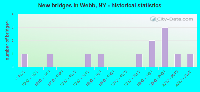
- New bridges - historical statistics
- 1Before 1900
- 11910-1919
- 11940-1949
- 11950-1959
- 11980-1989
- 21990-1999
- 32000-2009
- 12010-2019
- 12020-2022

- Reconstructed bridges - Historical Statistics
- 21980-1989
- 21990-1999


- Bridge Condition - Deck
- 10.0%Excellent
- 20.0%Very good
- 40.0%Good
- 30.0%Satisfactory

- Bridge Condition - Superstructure
- 10.0%Excellent
- 40.0%Very good
- 40.0%Good
- 10.0%Poor

- Bridge Condition - Substructure
- 30.0%Excellent
- 20.0%Very good
- 30.0%Good
- 20.0%Satisfactory

- Bridge Condition - Channel
- 9.1%Excellent
- 27.3%Very good
- 45.5%Good
- 18.2%Satisfactory
Find on map >> Show street view
Structure Number: 102023, Location: 7 MI SW OF THENDARA (Lat: 43.612700, Lng: -75.102428), Route carried "on" structure: State highway 28, Year Built: 1947, Year Reconstructed: 1990, Status: Open, Structure Length: 15.03m (49.31ft), Average Daily Traffic: 3,568 (year 2020), Truck Traffic: 12%, Average Future Daily Traffic: 3,590 (year 2040), Design Load: HS 20, Features Intersected: MOOSE RIVER
Minimum Vertical Clearance: 30+ m (98+ ft), Kilometerpoint: 1.207, Lanes on structure: 2, Base Highway Network: Yes, Owner: State Highway Agency, Approaching Roadway Width: 10.7m (35.1ft), Material/Design: Steel, Design/Construction: Stringer/Multi-beam, Number Of Spans In Main Unit: 7, Length of Maximum Span: 21.3m (69.9ft), Curb-To-Curb Width: 10.7m (35.1ft), Out-to-Out Width: 11.3m (37.1ft)
Condition: Deck: Good, Superstructure: Good, Substructure: Good, Channel: Good, Operating Rating: 64.4 metric tons, Method Used To Determine Operating Rating: Load Factor (LF), Inventory Rating: 39.0 metric tons, Method Used To Determine Inventory Rating: Load Factor (LF), Structural Evaluation: Better than present minimum criteria, Deck Geometry: Somewhat better than minimum adequacy, Waterway Adequacy: Somewhat better than minimum adequacy, Approach Roadway Alignment: Equal to present desirable criteria, Length Of Structure Improvement: 15.02m (49.28ft), Designated Inspection Frequency: Every 24 months, Inspection Date: August 2021, Bridge Improvement Cost: $2,532,000, Roadway Improvement Cost: $1,483,000, Total Project Cost: $4,014,000 ( Estimate for 2021), Deck Structure Type: Concrete Cast-file-Place, Wearing Surface/Protective System: Wearing Surface: Integral Concrete, Deck Protection: Epoxy Coated Reinforcing
Find on map >> Show street view
Structure Number: 102025, Location: 2.7 MI NE JCT SH12 & SH28 (Lat: 43.703628, Lng: -74.984469), Route carried "on" structure: State highway 28, Year Built: 1991, Status: Open, Structure Length: 3.35m (10.99ft), Average Daily Traffic: 4,683 (year 2020), Truck Traffic: 5%, Average Future Daily Traffic: 4,712 (year 2040), Design Load: HS 20, Features Intersected: M BR MOOSE RIVER
Minimum Vertical Clearance: 30+ m (98+ ft), Kilometerpoint: 16.718, Lanes on structure: 2, Base Highway Network: Yes, Owner: State Highway Agency, Approaching Roadway Width: 9.4m (30.8ft), Skew: 1 degrees, Material/Design: Steel, Design/Construction: Stringer/Multi-beam, Number Of Spans In Main Unit: 1, Length of Maximum Span: 32.3m (106.0ft), Curb or Sidewalk Widths: Left: 1.5m (4.9ft), Right: 0.0m, Curb-To-Curb Width: 9.4m (30.8ft), Out-to-Out Width: 11.6m (38.1ft)
Condition: Deck: Satisfactory, Superstructure: Good, Substructure: Good, Channel: Very good, Operating Rating: 69.9 metric tons, Method Used To Determine Operating Rating: Load Factor (LF), Inventory Rating: 34.5 metric tons, Method Used To Determine Inventory Rating: Load Factor (LF), Structural Evaluation: Better than present minimum criteria, Deck Geometry: Meets minimum limits, Waterway Adequacy: Equal to present minimum criteria, Approach Roadway Alignment: Equal to present desirable criteria, Length Of Structure Improvement: 3.35m (10.99ft), Designated Inspection Frequency: Every 24 months, Inspection Date: October 2021, Bridge Improvement Cost: $768,000, Roadway Improvement Cost: $450,000, Total Project Cost: $1,218,000 ( Estimate for 2021), Deck Structure Type: Concrete Cast-file-Place, Wearing Surface/Protective System: Wearing Surface: Integral Concrete, Deck Protection: Epoxy Coated Reinforcing
Find on map >> Show street view
Structure Number: 102026, Location: 27.6MI NW JCT RTS 12 & 28 (Lat: 43.712767, Lng: -74.969686), Route carried "on" structure: State highway 28, Year Built: 2000, Status: Open, Structure Length: 1.40m (4.59ft), Average Daily Traffic: 4,134 (year 2020), Truck Traffic: 8%, Average Future Daily Traffic: 4,159 (year 2040), Design Load: HS 25 or greater, Features Intersected: MOOSE RIVER
Minimum Vertical Clearance: 30+ m (98+ ft), Kilometerpoint: 18.343, Lanes on structure: 3, Base Highway Network: Yes, Owner: State Highway Agency, Approaching Roadway Width: 12.2m (40.0ft), Skew: 1 degrees, Material/Design: Prestressed concrete, Design/Construction: Box Beam or Girders - Multiple, Number Of Spans In Main Unit: 1, Length of Maximum Span: 13.1m (43.0ft), Curb or Sidewalk Widths: Left: 1.5m (4.9ft), Right: 1.5m (4.9ft), Curb-To-Curb Width: 12.3m (40.4ft), Out-to-Out Width: 16.1m (52.8ft)
Condition: Deck: Very good, Superstructure: Very good, Substructure: Excellent, Channel: Excellent, Operating Rating: 77.1 metric tons, Method Used To Determine Operating Rating: Load Factor (LF), Inventory Rating: 32.7 metric tons, Method Used To Determine Inventory Rating: Load Factor (LF), Structural Evaluation: Equal to present desirable criteria, Deck Geometry: Meets minimum limits, Waterway Adequacy: Equal to present desirable criteria, Approach Roadway Alignment: Equal to present desirable criteria, Length Of Structure Improvement: 1.40m (4.59ft), Designated Inspection Frequency: Every 24 months, Inspection Date: October 2021, Bridge Improvement Cost: $863,000, Roadway Improvement Cost: $506,000, Total Project Cost: $1,369,000 ( Estimate for 2021), Deck Structure Type: Concrete Cast-file-Place, Wearing Surface/Protective System: Wearing Surface: Bituminous, Deck Protection: Epoxy Coated Reinforcing
Find on map >> Show street view
Structure Number: 220492, Location: 4 MILES SW OF BRANDRETH (Lat: 43.904675, Lng: -74.906717), Route carried "on" structure: Other road , Year Built: 1991, Status: Open, Structure Length: 3.08m (10.10ft), Truck Traffic: 4%, Features Intersected: BEAVER RIVER, Facility Carried by Structure: BULLOCK RD
Minimum Vertical Clearance: 30+ m (98+ ft), Kilometerpoint: 0.338, Lanes on structure: 1, Owner: Town or Township Highway Agency, Approaching Roadway Width: 3.7m (12.1ft), Material/Design: Steel, Design/Construction: Culvert, Number Of Spans In Main Unit: 9, Length of Maximum Span: 3.3m (10.8ft), Curb-To-Curb Width: 5.6m (18.4ft), Out-to-Out Width: 6.2m (20.3ft)
Condition: Channel: Good, Culverts: Good, Operating Rating: 74.9 metric tons, Method Used To Determine Operating Rating: Field evaluation and documented engineering judgment, Inventory Rating: 32.7 metric tons, Method Used To Determine Inventory Rating: Field evaluation and documented engineering judgment, Structural Evaluation: Better than present minimum criteria, Deck Geometry: Meets minimum limits, Waterway Adequacy: Somewhat better than minimum adequacy, Approach Roadway Alignment: Equal to present desirable criteria, Length Of Structure Improvement: 3.07m (10.07ft), Designated Inspection Frequency: Every 24 months, Inspection Date: April 2021, Bridge Improvement Cost: $275,000, Roadway Improvement Cost: $161,000, Total Project Cost: $437,000 ( Estimate for 2021)
Find on map >> Show street view
Structure Number: 220493, Location: .5 MI SW OF OLD FORGE (Lat: 43.694903, Lng: -74.998606), Route carried "on" structure: Other road , Year Built: 1985, Status: Open, Structure Length: 3.17m (10.40ft), Average Daily Traffic: 177 (year 2016), Truck Traffic: 2%, Average Future Daily Traffic: 248 (year 2036), Design Load: HS 20, Features Intersected: M BR MOOSE RIVER, Facility Carried by Structure: GREENBRIDGE ROAD
Minimum Vertical Clearance: 30+ m (98+ ft), Kilometerpoint: 0.274, Lanes on structure: 2, Owner: Town or Township Highway Agency, Approaching Roadway Width: 6.7m (22.0ft), Material/Design: Steel, Design/Construction: Stringer/Multi-beam, Number Of Spans In Main Unit: 1, Length of Maximum Span: 30.4m (99.7ft), Curb-To-Curb Width: 6.7m (22.0ft), Out-to-Out Width: 7.3m (24.0ft)
Condition: Deck: Good, Superstructure: Very good, Substructure: Very good, Channel: Very good, Operating Rating: 94.3 metric tons, Method Used To Determine Operating Rating: Load Factor (LF), Inventory Rating: 56.2 metric tons, Method Used To Determine Inventory Rating: Load Factor (LF), Structural Evaluation: Equal to present desirable criteria, Deck Geometry: Meets minimum limits, Waterway Adequacy: Somewhat better than minimum adequacy, Approach Roadway Alignment: Equal to present desirable criteria, Length Of Structure Improvement: 3.16m (10.37ft), Designated Inspection Frequency: Every 24 months, Inspection Date: July 2021, Bridge Improvement Cost: $359,000, Roadway Improvement Cost: $210,000, Total Project Cost: $570,000 ( Estimate for 2021), Deck Structure Type: Concrete Cast-file-Place, Wearing Surface/Protective System: Wearing Surface: Integral Concrete, Deck Protection: Epoxy Coated Reinforcing
Find on map >> Show street view
Structure Number: 220494, Location: 4 MI NE OF OLD FORGE (Lat: 43.763119, Lng: -74.920481), Route carried "on" structure: Other road , Year Built: 1910, Year Reconstructed: 1992, Status: Open, Structure Length: 2.23m (7.32ft), Average Daily Traffic: 39 (year 2018), Truck Traffic: 4%, Average Future Daily Traffic: 55 (year 2038), Design Load: H 20, Features Intersected: N BR MOOSE RIVER, Facility Carried by Structure: RONDAXE ROAD
Minimum Vertical Clearance: 30+ m (98+ ft), Kilometerpoint: 0.949, Lanes on structure: 1, Owner: Town or Township Highway Agency, Approaching Roadway Width: 4.6m (15.1ft), Material/Design: Prestressed concrete, Design/Construction: Box Beam or Girders - Multiple, Number Of Spans In Main Unit: 1, Length of Maximum Span: 21.6m (70.9ft), Curb-To-Curb Width: 4.6m (15.1ft), Out-to-Out Width: 4.9m (16.1ft)
Condition: Deck: Satisfactory, Superstructure: Good, Substructure: Good, Channel: Good, Operating Rating: 59.9 metric tons, Method Used To Determine Operating Rating: Load Factor (LF), Inventory Rating: 39.0 metric tons, Method Used To Determine Inventory Rating: Load Factor (LF), Structural Evaluation: Better than present minimum criteria, Deck Geometry: Better than present minimum criteria, Waterway Adequacy: Somewhat better than minimum adequacy, Approach Roadway Alignment: Somewhat better than minimum adequacy, Length Of Structure Improvement: 2.22m (7.28ft), Designated Inspection Frequency: Every 24 months, Inspection Date: August 2020, Bridge Improvement Cost: $287,000, Roadway Improvement Cost: $168,000, Total Project Cost: $455,000 ( Estimate for 2021), Wearing Surface/Protective System: Wearing Surface: Integral Concrete
Find on map >> Show street view
Structure Number: 220495, Location: 3.5 MI NW EAGLE BAY (Lat: 43.816789, Lng: -74.856142), Route carried "on" structure: Other road , Year Built: 1950, Year Reconstructed: 1992, Status: Open, Structure Length: 1.58m (5.18ft), Average Daily Traffic: 91 (year 2017), Average Future Daily Traffic: 127 (year 2037), Features Intersected: OUTLET SOUTH BAY, Facility Carried by Structure: COVEY ROAD
Minimum Vertical Clearance: 30+ m (98+ ft), Kilometerpoint: 0.241, Lanes on structure: 1, Owner: Town or Township Highway Agency, Approaching Roadway Width: 4.9m (16.1ft), Material/Design: Prestressed concrete, Design/Construction: Box Beam or Girders - Multiple, Number Of Spans In Main Unit: 1, Length of Maximum Span: 15.2m (49.9ft), Curb-To-Curb Width: 4.8m (15.7ft), Out-to-Out Width: 4.9m (16.1ft)
Condition: Deck: Good, Superstructure: Good, Substructure: Satisfactory, Channel: Satisfactory, Operating Rating: 55.3 metric tons, Method Used To Determine Operating Rating: Load Factor (LF), Inventory Rating: 38.1 metric tons, Method Used To Determine Inventory Rating: Load Factor (LF), Structural Evaluation: Equal to present minimum criteria, Deck Geometry: Equal to present desirable criteria, Waterway Adequacy: Meets minimum limits, Approach Roadway Alignment: Equal to present minimum criteria, Length Of Structure Improvement: 1.58m (5.18ft), Designated Inspection Frequency: Every 24 months, Inspection Date: July 2020, Bridge Improvement Cost: $189,000, Roadway Improvement Cost: $110,000, Total Project Cost: $299,000 ( Estimate for 2021), Wearing Surface/Protective System: Wearing Surface: Other
Find on map >> Show street view
Structure Number: 226357, Location: 1.5 MILES SE OF CARTER (Lat: 43.758506, Lng: -74.933539), Route carried "on" structure: Other road , Year Built: 1895, Year Reconstructed: 2003, Status: Posted for load, Structure Length: 3.20m (10.50ft), Truck Traffic: 10%, Features Intersected: N BR MOOSE RIVER, Facility Carried by Structure: SNOWMOBILE TRAIL
Minimum Vertical Clearance: 5.05m (16.57ft), Kilometerpoint: 1.303, Lanes on structure: 1, Owner: Town or Township Highway Agency, Approaching Roadway Width: 4.0m (13.1ft), Material/Design: Steel, Design/Construction: Truss - Thru, Number Of Spans In Main Unit: 1, Length of Maximum Span: 31.4m (103.0ft), Curb-To-Curb Width: 4.0m (13.1ft), Out-to-Out Width: 6.9m (22.6ft)
Condition: Deck: Satisfactory, Superstructure: Poor, Substructure: Satisfactory, Channel: Satisfactory, Operating Rating: 4.5 metric tons, Method Used To Determine Operating Rating: Field evaluation and documented engineering judgment, Inventory Rating: 4.5 metric tons, Method Used To Determine Inventory Rating: Field evaluation and documented engineering judgment, Structural Evaluation: High priority of corrective action, Deck Geometry: Somewhat better than minimum adequacy, Waterway Adequacy: Meets minimum limits, Approach Roadway Alignment: High priority of corrective action, Bridge Posting: Required (Relationship of Operating Rating to Maximum Legal Load: > 39.9% below), Length Of Structure Improvement: 3.13m (10.27ft), Designated Inspection Frequency: Every 12 months, Critical Feature Inspection Frequency: Every 12 months, Inspection Date: August 2021, Critical Feature Inspection Date: August 2021, Bridge Improvement Cost: $1,251,000, Roadway Improvement Cost: $733,000, Total Project Cost: $1,984,000 ( Estimate for 2021), Deck Structure Type: Wood or Timber, Wearing Surface/Protective System: Wearing Surface: Other
Find on map >> Show street view
Structure Number: 227134, Location: 19 Miles NW of Eagle Bay (Lat: 43.895342, Lng: -75.047519), Route carried "on" structure: Other road , Year Built: 2002, Status: Open, Structure Length: 1.13m (3.71ft), Design Load: HS 25 or greater, Features Intersected: Stillwater Spillway Chan, Facility Carried by Structure: Necessary Dam Rd
Minimum Vertical Clearance: 32.69m (107.25ft), Kilometerpoint: 1.175, Lanes on structure: 2, Owner: State Agenciy, Approaching Roadway Width: 6.1m (20.0ft), Material/Design: Concrete, Design/Construction: Frame, Number Of Spans In Main Unit: 1, Length of Maximum Span: 10.4m (34.1ft), Curb-To-Curb Width: 5.4m (17.7ft), Out-to-Out Width: 6.1m (20.0ft)
Condition: Deck: Good, Superstructure: Very good, Substructure: Very good, Channel: Good, Operating Rating: 97.2 metric tons, Method Used To Determine Operating Rating: Load and Resistance Factor Rating (LRFR) rating reported by rating factor(RF) method using HL-93 loadings, Inventory Rating: 81.6 metric tons, Method Used To Determine Inventory Rating: Load and Resistance Factor Rating (LRFR) rating reported by rating factor(RF) method using HL-93 loadings, Structural Evaluation: Equal to present desirable criteria, Deck Geometry: High priority of corrective action, Waterway Adequacy: Better than present minimum criteria, Approach Roadway Alignment: Equal to present minimum criteria, Length Of Structure Improvement: 1.12m (3.67ft), Designated Inspection Frequency: Every 24 months, Inspection Date: August 2020, Bridge Improvement Cost: $235,000, Roadway Improvement Cost: $138,000, Total Project Cost: $373,000 ( Estimate for 2021), Wearing Surface/Protective System: Wearing Surface: Other
Find on map >> Show street view
Structure Number: 330821, Location: 3 MILES EAST OF BIG MOOSE (Lat: 43.809808, Lng: -74.854200), Route carried "on" structure: County highway , Year Built: 2010, Status: Open, Structure Length: 2.23m (7.32ft), Average Daily Traffic: 449 (year 2017), Truck Traffic: 8%, Average Future Daily Traffic: 629 (year 2037), Design Load: HL 93, Features Intersected: N BR MOOSE RIVER, Facility Carried by Structure: CR1 BIG MOOSE ROAD
Minimum Vertical Clearance: 30+ m (98+ ft), Kilometerpoint: 6.259, Lanes on structure: 2, Owner: County Highway Agency, Approaching Roadway Width: 7.0m (23.0ft), Skew: 2 degrees, Material/Design: Prestressed concrete, Design/Construction: Box Beam or Girders - Multiple, Number Of Spans In Main Unit: 1, Length of Maximum Span: 21.3m (69.9ft), Curb-To-Curb Width: 10.1m (33.1ft), Out-to-Out Width: 11.2m (36.7ft)
Condition: Deck: Very good, Superstructure: Very good, Substructure: Excellent, Channel: Good, Operating Rating: 75.5 metric tons, Method Used To Determine Operating Rating: Load and Resistance Factor Rating (LRFR) rating reported by rating factor(RF) method using HL-93 loadings, Inventory Rating: 58.3 metric tons, Method Used To Determine Inventory Rating: Load and Resistance Factor Rating (LRFR) rating reported by rating factor(RF) method using HL-93 loadings, Structural Evaluation: Equal to present desirable criteria, Deck Geometry: Equal to present minimum criteria, Waterway Adequacy: Equal to present minimum criteria, Approach Roadway Alignment: Equal to present desirable criteria, Length Of Structure Improvement: 2.22m (7.28ft), Designated Inspection Frequency: Every 24 months, Inspection Date: July 2020, Bridge Improvement Cost: $556,000, Roadway Improvement Cost: $325,000, Total Project Cost: $881,000 ( Estimate for 2021), Wearing Surface/Protective System: Wearing Surface: Bituminous
Find on map >> Show street view
Structure Number: 330822, Location: 2.5 MI E OLD FORGE (Lat: 43.710339, Lng: -74.950511), Route carried "on" structure: County highway , Year Built: 2021, Status: Open, Structure Length: 1.19m (3.90ft), Average Daily Traffic: 1,346 (year 2017), Truck Traffic: 9%, Average Future Daily Traffic: 1,884 (year 2037), Design Load: HL 93, Features Intersected: TWIN POND OUTLET, Facility Carried by Structure: CR118 SOUTH SHORE
Minimum Vertical Clearance: 30+ m (98+ ft), Kilometerpoint: 1.062, Lanes on structure: 2, Owner: County Highway Agency, Approaching Roadway Width: 9.1m (29.9ft), Material/Design: Concrete, Design/Construction: Frame, Number Of Spans In Main Unit: 1, Length of Maximum Span: 11.0m (36.1ft), Curb-To-Curb Width: 9.1m (29.9ft), Out-to-Out Width: 10.1m (33.1ft)
Condition: Deck: Excellent, Superstructure: Excellent, Substructure: Excellent, Channel: Very good, Operating Rating: 80.4 metric tons, Method Used To Determine Operating Rating: Field evaluation and documented engineering judgment, Inventory Rating: 40.8 metric tons, Method Used To Determine Inventory Rating: Field evaluation and documented engineering judgment, Structural Evaluation: Superior to present desirable criteria, Deck Geometry: Somewhat better than minimum adequacy, Waterway Adequacy: Somewhat better than minimum adequacy, Approach Roadway Alignment: Meets minimum limits, Length Of Structure Improvement: 0.70m (2.30ft), Designated Inspection Frequency: Every 24 months, Inspection Date: December 2021, Bridge Improvement Cost: $218,000, Roadway Improvement Cost: $127,000, Total Project Cost: $345,000 ( Estimate for 2021)
Find on map >> Show street view
Structure Number: 702024, Location: THENDARA (Lat: 43.700636, Lng: -75.003494), Route carried "under" structure: State highway 28, Year Built: 2006, Structure Length: 0. m, Average Daily Traffic: 3,564 (year 2000), Features Intersected: RTE 28, Facility Carried by Structure: ADIRONDACK SCENIC
Minimum Vertical Clearance: 4.55m (14.93ft), Kilometerpoint: 14.626, Lanes under structure: 2, Material/Design: Steel, Design/Construction: Girder and Floorbeam System, Length of Maximum Span: 31.5m (103.3ft)