Bridge Statistics for Webster Groves, Missouri (MO)
Condition, Traffic, Stress, Structural Evaluation, Project Costs
- National Bridge Inventory (NBI) Statistics
- 35Number of bridges
- 397ft / 121mTotal length
- $7,743,000Total costs
- 1,093,638Total average daily traffic
- 116,377Total average daily truck traffic
- National Bridge Inventory (NBI) Registered Bridges for Webster Groves
- No street view available for this location
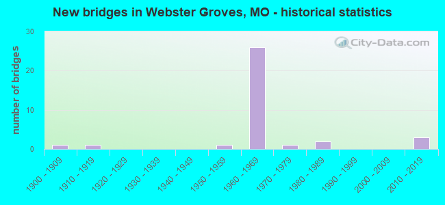
- New bridges - historical statistics
- 11900-1909
- 11910-1919
- 11950-1959
- 261960-1969
- 11970-1979
- 21980-1989
- 32010-2019
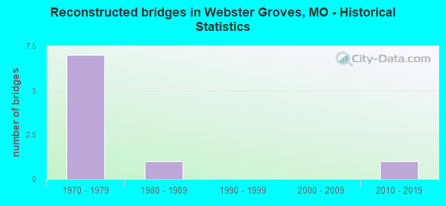
- Reconstructed bridges - Historical Statistics
- 71970-1979
- 11980-1989
- 01990-1999
- 02000-2009
- 12010-2019
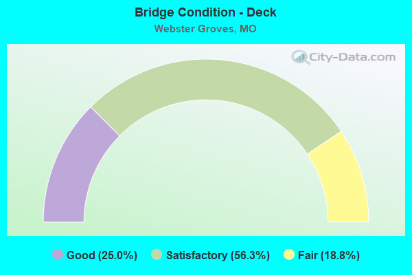
- Bridge Condition - Deck
- 25.0%Good
- 56.3%Satisfactory
- 18.8%Fair
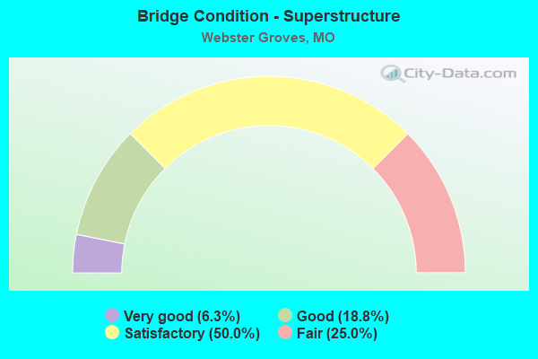
- Bridge Condition - Superstructure
- 6.3%Very good
- 18.8%Good
- 50.0%Satisfactory
- 25.0%Fair
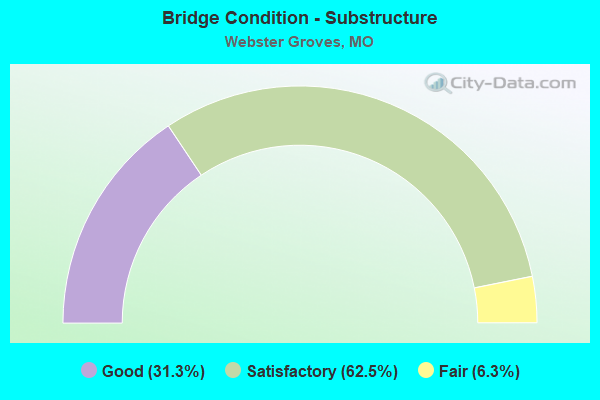
- Bridge Condition - Substructure
- 31.3%Good
- 62.5%Satisfactory
- 6.3%Fair
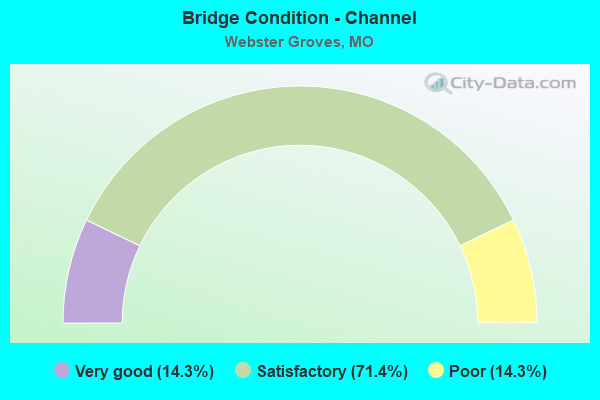
- Bridge Condition - Channel
- 14.3%Very good
- 71.4%Satisfactory
- 14.3%Poor
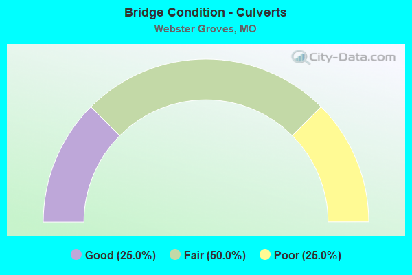
- Bridge Condition - Culverts
- 25.0%Good
- 50.0%Fair
- 25.0%Poor
Find on map >> Show street view
Structure Number: 1422, Location: S 5 T 44 N R 6 E (Lat: 38.578433, Lng: -90.367672), Route carried "on" structure: City street , Year Built: 1969, Year Reconstructed: 1984, Status: Open, Structure Length: 7.65m (25.10ft), Average Daily Traffic: 4,302 (year 2021), Truck Traffic: 5%, Average Future Daily Traffic: 6,453 (year 2041), Design Load: H 20, Features Intersected: IS 44, Facility Carried by Structure: SO ROCK HILL RD S
Minimum Vertical Clearance: 30+ m (98+ ft), Kilometerpoint: 0.225, Lanes on structure: 2, Lanes under structure: 8, Owner: State Highway Agency, Approaching Roadway Width: 7.3m (24.0ft), Skew: 2 degrees, Material/Design: Concrete continuous, Design/Construction: Box Beam or Girders - Single/Spread, Number Of Spans In Main Unit: 4, Length of Maximum Span: 24.8m (81.4ft), Curb or Sidewalk Widths: Left: 1.5m (4.9ft), Right: 1.5m (4.9ft), Curb-To-Curb Width: 8.5m (27.9ft), Out-to-Out Width: 12.1m (39.7ft)
Condition: Deck: Satisfactory, Superstructure: Satisfactory, Substructure: Satisfactory, Operating Rating: 70.2 metric tons, Method Used To Determine Operating Rating: Load Factor (LF), Inventory Rating: 42.3 metric tons, Method Used To Determine Inventory Rating: Load Factor (LF), Structural Evaluation: Equal to present minimum criteria, Deck Geometry: Meets minimum limits, Underclear: Meets minimum limits, Approach Roadway Alignment: Better than present minimum criteria, Designated Inspection Frequency: Every 24 months, Inspection Date: June 2020, Deck Structure Type: Concrete Cast-file-Place, Wearing Surface/Protective System: Wearing Surface: Bituminous, Membrane: Built-up
Find on map >> Show street view
Structure Number: 1423, Location: S 4 T 44 N R 6 E (Lat: 38.580244, Lng: -90.359561), Route carried "on" structure: Interstate 44, Year Built: 1969, Status: Open, Structure Length: 5.24m (17.19ft), Average Daily Traffic: 59,157 (year 2021), Truck Traffic: 12%, Average Future Daily Traffic: 73,946 (year 2041), Design Load: HS 20+Mod, Features Intersected: CST ELM AVE
Minimum Vertical Clearance: 30+ m (98+ ft), Kilometerpoint: 451.787, Lanes on structure: 4, Lanes under structure: 6, Base Highway Network: Yes, Owner: State Highway Agency, Approaching Roadway Width: 18.9m (62.0ft), Skew: 1 degrees, Material/Design: Concrete continuous, Design/Construction: Slab, Number Of Spans In Main Unit: 4, Length of Maximum Span: 16.8m (55.1ft), Curb-To-Curb Width: 20.6m (67.6ft), Out-to-Out Width: 21.5m (70.5ft)
Condition: Deck: Satisfactory, Superstructure: Satisfactory, Substructure: Satisfactory, Operating Rating: 51.3 metric tons, Method Used To Determine Operating Rating: Load Factor (LF), Inventory Rating: 30.6 metric tons, Method Used To Determine Inventory Rating: Load Factor (LF), Structural Evaluation: Equal to present minimum criteria, Deck Geometry: Equal to present minimum criteria, Underclear: High priority of corrective action, Approach Roadway Alignment: Equal to present desirable criteria, Designated Inspection Frequency: Every 24 months, Inspection Date: June 2020, Deck Structure Type: Concrete Cast-file-Place, Wearing Surface/Protective System: Wearing Surface: Bituminous
Find on map >> Show street view
Structure Number: 1424, Location: S 4 T 44 N R 6 E (Lat: 38.580431, Lng: -90.359583), Route carried "on" structure: Interstate 44, Year Built: 1969, Status: Open, Structure Length: 5.24m (17.19ft), Average Daily Traffic: 59,813 (year 2021), Truck Traffic: 12%, Average Future Daily Traffic: 74,766 (year 2041), Design Load: HS 20+Mod, Features Intersected: CST ELM AVE
Minimum Vertical Clearance: 30+ m (98+ ft), Kilometerpoint: 19.850, Lanes on structure: 4, Lanes under structure: 6, Base Highway Network: Yes, Owner: State Highway Agency, Approaching Roadway Width: 18.9m (62.0ft), Skew: 1 degrees, Material/Design: Concrete continuous, Design/Construction: Slab, Number Of Spans In Main Unit: 4, Length of Maximum Span: 16.8m (55.1ft), Curb-To-Curb Width: 20.0m (65.6ft), Out-to-Out Width: 20.8m (68.2ft)
Condition: Deck: Fair, Superstructure: Fair, Substructure: Satisfactory, Operating Rating: 51.3 metric tons, Method Used To Determine Operating Rating: Load Factor (LF), Inventory Rating: 30.6 metric tons, Method Used To Determine Inventory Rating: Load Factor (LF), Structural Evaluation: Somewhat better than minimum adequacy, Deck Geometry: Equal to present minimum criteria, Underclear: High priority of corrective action, Approach Roadway Alignment: Equal to present desirable criteria, Length Of Structure Improvement: 0.63m (2.07ft), Designated Inspection Frequency: Every 24 months, Inspection Date: June 2020, Bridge Improvement Cost: $819,000, Roadway Improvement Cost: $82,000, Total Project Cost: $1,229,000 ( Estimate for 2022), Deck Structure Type: Concrete Cast-file-Place, Wearing Surface/Protective System: Wearing Surface: Bituminous
Find on map >> Show street view
Structure Number: 1426, Location: S 4 T 44 N R 6 E (Lat: 38.585328, Lng: -90.345392), Route carried "on" structure: City street , Year Built: 1969, Year Reconstructed: 1984, Status: Open, Structure Length: 10.97m (35.99ft), Average Daily Traffic: 5,627 (year 2021), Truck Traffic: 5%, Average Future Daily Traffic: 8,441 (year 2041), Design Load: H 20, Features Intersected: IS 44, BNSF RR, Facility Carried by Structure: EDGAR RD S
Minimum Vertical Clearance: 30+ m (98+ ft), Kilometerpoint: 0.484, Lanes on structure: 2, Lanes under structure: 8, Owner: State Highway Agency, Approaching Roadway Width: 7.3m (24.0ft), Skew: 2 degrees, Material/Design: Concrete continuous, Design/Construction: Box Beam or Girders - Single/Spread, Number Of Spans In Main Unit: 4, Number Of Approach Spans: 2, Length of Maximum Span: 25.6m (84.0ft), Curb-To-Curb Width: 7.9m (25.9ft), Out-to-Out Width: 11.5m (37.7ft)
Condition: Deck: Satisfactory, Superstructure: Fair, Substructure: Satisfactory, Operating Rating: 55.8 metric tons, Method Used To Determine Operating Rating: Allowable Stress (AS), Inventory Rating: 29.7 metric tons, Method Used To Determine Inventory Rating: Allowable Stress (AS), Structural Evaluation: Somewhat better than minimum adequacy, Deck Geometry: High priority of corrective action, Underclear: Equal to present minimum criteria, Approach Roadway Alignment: Equal to present minimum criteria, Length Of Structure Improvement: 1.19m (3.90ft), Designated Inspection Frequency: Every 24 months, Inspection Date: June 2020, Bridge Improvement Cost: $1,018,000, Roadway Improvement Cost: $102,000, Total Project Cost: $1,527,000 ( Estimate for 2022), Deck Structure Type: Concrete Cast-file-Place, Wearing Surface/Protective System: Wearing Surface: Bituminous, Membrane: Built-up
Find on map >> Show street view
Structure Number: 1428, Location: S 34 T 45 N R 6 E (Lat: 38.593592, Lng: -90.332292), Route carried "on" structure: Interstate 44, Year Built: 1969, Status: Posted for load, Structure Length: 5.76m (18.90ft), Average Daily Traffic: 37,009 (year 2021), Truck Traffic: 12%, Average Future Daily Traffic: 46,261 (year 2041), Design Load: HS 20+Mod, Features Intersected: CST LACLEDE STATION RD
Minimum Vertical Clearance: 30+ m (98+ ft), Kilometerpoint: 454.645, Lanes on structure: 4, Lanes under structure: 4, Base Highway Network: Yes, Owner: State Highway Agency, Approaching Roadway Width: 19.5m (64.0ft), Skew: 3 degrees, Material/Design: Concrete continuous, Design/Construction: Slab, Number Of Spans In Main Unit: 4, Length of Maximum Span: 16.5m (54.1ft), Curb-To-Curb Width: 20.4m (66.9ft), Out-to-Out Width: 21.4m (70.2ft)
Condition: Deck: Satisfactory, Superstructure: Satisfactory, Substructure: Satisfactory, Operating Rating: 48.6 metric tons, Method Used To Determine Operating Rating: Load Factor (LF), Inventory Rating: 29.7 metric tons, Method Used To Determine Inventory Rating: Load Factor (LF), Structural Evaluation: Equal to present minimum criteria, Deck Geometry: Equal to present minimum criteria, Underclear: Meets minimum limits, Approach Roadway Alignment: Equal to present desirable criteria, Designated Inspection Frequency: Every 24 months, Inspection Date: June 2020, Deck Structure Type: Concrete Cast-file-Place, Wearing Surface/Protective System: Wearing Surface: Other, Membrane: Built-up
Find on map >> Show street view
Structure Number: 1429, Location: S 34 T 45 N R 6 E (Lat: 38.593800, Lng: -90.332278), Route carried "on" structure: Interstate 44, Year Built: 1969, Status: Posted for load, Structure Length: 5.76m (18.90ft), Average Daily Traffic: 39,037 (year 2021), Truck Traffic: 12%, Average Future Daily Traffic: 48,796 (year 2041), Design Load: HS 20+Mod, Features Intersected: CST LACLEDE STATION RD
Minimum Vertical Clearance: 30+ m (98+ ft), Kilometerpoint: 16.985, Lanes on structure: 4, Lanes under structure: 4, Base Highway Network: Yes, Owner: State Highway Agency, Approaching Roadway Width: 19.5m (64.0ft), Skew: 3 degrees, Material/Design: Concrete continuous, Design/Construction: Slab, Number Of Spans In Main Unit: 4, Length of Maximum Span: 16.5m (54.1ft), Curb-To-Curb Width: 20.4m (66.9ft), Out-to-Out Width: 20.8m (68.2ft)
Condition: Deck: Satisfactory, Superstructure: Satisfactory, Substructure: Satisfactory, Operating Rating: 51.3 metric tons, Method Used To Determine Operating Rating: Load Factor (LF), Inventory Rating: 30.6 metric tons, Method Used To Determine Inventory Rating: Load Factor (LF), Structural Evaluation: Equal to present minimum criteria, Deck Geometry: Equal to present minimum criteria, Underclear: Somewhat better than minimum adequacy, Approach Roadway Alignment: Equal to present desirable criteria, Designated Inspection Frequency: Every 24 months, Inspection Date: June 2020, Deck Structure Type: Concrete Cast-file-Place, Wearing Surface/Protective System: Wearing Surface: Other, Membrane: Built-up
Find on map >> Show street view
Structure Number: 143, Location: S 7 T 48 N R 13 W (Lat: 38.971742, Lng: -92.430917), Route carried "on" structure: US 40, Year Built: 1958, Year Reconstructed: 2010, Status: Open, Structure Length: 8.26m (27.10ft), Average Daily Traffic: 8,154 (year 2021), Truck Traffic: 6%, Average Future Daily Traffic: 15,085 (year 2041), Design Load: H 20, Features Intersected: IS 70
Minimum Vertical Clearance: 30+ m (98+ ft), Kilometerpoint: 202.829, Lanes on structure: 2, Lanes under structure: 4, Owner: State Highway Agency, Approaching Roadway Width: 9.1m (29.9ft), Skew: 4 degrees, Material/Design: Steel continuous, Design/Construction: Stringer/Multi-beam, Number Of Spans In Main Unit: 4, Length of Maximum Span: 23.5m (77.1ft), Curb-To-Curb Width: 9.1m (29.9ft), Out-to-Out Width: 10.0m (32.8ft)
Condition: Deck: Satisfactory, Superstructure: Satisfactory, Substructure: Good, Operating Rating: 55.8 metric tons, Method Used To Determine Operating Rating: Load Factor (LF), Inventory Rating: 33.3 metric tons, Method Used To Determine Inventory Rating: Load Factor (LF), Structural Evaluation: Equal to present minimum criteria, Deck Geometry: Meets minimum limits, Underclear: Meets minimum limits, Approach Roadway Alignment: Equal to present minimum criteria, Designated Inspection Frequency: Every 24 months, Inspection Date: September 2021, Deck Structure Type: Concrete Cast-file-Place, Wearing Surface/Protective System: Wearing Surface: Monolithic Concrete, Deck Protection: Epoxy Coated Reinforcing
Find on map >> Show street view
Structure Number: 143, Location: S 34 T 45 N R 6 E (Lat: 38.594953, Lng: -90.326506), Route carried "on" structure: City street , Year Built: 1969, Year Reconstructed: 1984, Status: Open, Structure Length: 7.41m (24.31ft), Average Daily Traffic: 16,794 (year 2021), Truck Traffic: 5%, Average Future Daily Traffic: 23,512 (year 2041), Design Load: HS 20, Features Intersected: IS 44, RP IS44W TO SHREW, Facility Carried by Structure: SHREWSBURY AVE S
Minimum Vertical Clearance: 30+ m (98+ ft), Kilometerpoint: 0.668, Lanes on structure: 4, Lanes under structure: 7, Owner: State Highway Agency, Approaching Roadway Width: 18.9m (62.0ft), Material/Design: Concrete continuous, Design/Construction: Box Beam or Girders - Single/Spread, Number Of Spans In Main Unit: 4, Length of Maximum Span: 25.3m (83.0ft), Curb or Sidewalk Widths: Left: 1.5m (4.9ft), Right: 1.5m (4.9ft), Curb-To-Curb Width: 18.9m (62.0ft), Out-to-Out Width: 21.4m (70.2ft)
Condition: Deck: Fair, Superstructure: Fair, Substructure: Satisfactory, Operating Rating: 68.4 metric tons, Method Used To Determine Operating Rating: Load Factor (LF), Inventory Rating: 41.4 metric tons, Method Used To Determine Inventory Rating: Load Factor (LF), Structural Evaluation: Somewhat better than minimum adequacy, Deck Geometry: Equal to present minimum criteria, Underclear: High priority of corrective action, Approach Roadway Alignment: Equal to present desirable criteria, Length Of Structure Improvement: 0.84m (2.76ft), Designated Inspection Frequency: Every 24 months, Inspection Date: June 2020, Bridge Improvement Cost: $1,126,000, Roadway Improvement Cost: $113,000, Total Project Cost: $1,689,000 ( Estimate for 2022), Deck Structure Type: Concrete Cast-file-Place, Wearing Surface/Protective System: Wearing Surface: Bituminous
Find on map >> Show street view
Structure Number: 15639, Location: S 28 T 45 N R 6 E (Lat: 38.605717, Lng: -90.350572), Route carried "on" structure: County highway , Year Built: 1912, Year Reconstructed: 1981, Status: Posted for load, Structure Length: 4.02m (13.19ft), Average Daily Traffic: 23,967 (year 2020), Truck Traffic: 10%, Average Future Daily Traffic: 32,355 (year 2040), Design Load: HS 20, Features Intersected: DEER CR, Facility Carried by Structure: BRENTWOOD BLVD
Minimum Vertical Clearance: 30+ m (98+ ft), Kilometerpoint: 0.000, Lanes on structure: 4, Owner: County Highway Agency, Approaching Roadway Width: 19.5m (64.0ft), Material/Design: Prestressed concrete continuous, Design/Construction: Stringer/Multi-beam, Number Of Spans In Main Unit: 3, Length of Maximum Span: 13.1m (43.0ft), Curb or Sidewalk Widths: Left: 1.8m (5.9ft), Right: 1.8m (5.9ft), Curb-To-Curb Width: 19.5m (64.0ft), Out-to-Out Width: 24.4m (80.1ft)
Condition: Deck: Good, Superstructure: Good, Substructure: Good, Channel: Satisfactory, Operating Rating: 62.1 metric tons, Method Used To Determine Operating Rating: Allowable Stress (AS), Inventory Rating: 38.7 metric tons, Method Used To Determine Inventory Rating: Allowable Stress (AS), Structural Evaluation: Better than present minimum criteria, Deck Geometry: Better than present minimum criteria, Waterway Adequacy: Superior to present desirable criteria, Approach Roadway Alignment: Equal to present desirable criteria, Designated Inspection Frequency: Every 24 months, Inspection Date: March 2020, Deck Structure Type: Concrete Cast-file-Place, Wearing Surface/Protective System: Wearing Surface: Monolithic Concrete, Membrane: Epoxy, Deck Protection: Epoxy Coated Reinforcing
Find on map >> Show street view
Structure Number: 15641, Location: S 28 T 45 N R 6 E (Lat: 38.602036, Lng: -90.331594), Route carried "on" structure: County highway , Year Built: 1974, Year Reconstructed: 1994, Status: Posted for load, Structure Length: 3.81m (12.50ft), Average Daily Traffic: 34,312 (year 2020), Truck Traffic: 10%, Average Future Daily Traffic: 46,321 (year 2040), Design Load: HS 20, Features Intersected: DEER CR, Facility Carried by Structure: LACLEDE STA. RD
Minimum Vertical Clearance: 30+ m (98+ ft), Kilometerpoint: 0.000, Lanes on structure: 4, Owner: County Highway Agency, Approaching Roadway Width: 17.4m (57.1ft), Skew: 1 degrees, Material/Design: Steel continuous, Design/Construction: Stringer/Multi-beam, Number Of Spans In Main Unit: 2, Length of Maximum Span: 19.0m (62.3ft), Curb or Sidewalk Widths: Left: 1.5m (4.9ft), Right: 1.5m (4.9ft), Curb-To-Curb Width: 17.4m (57.1ft), Out-to-Out Width: 21.2m (69.6ft)
Condition: Deck: Satisfactory, Superstructure: Satisfactory, Substructure: Satisfactory, Channel: Satisfactory, Operating Rating: 89.1 metric tons, Method Used To Determine Operating Rating: Allowable Stress (AS), Inventory Rating: 69.3 metric tons, Method Used To Determine Inventory Rating: Allowable Stress (AS), Structural Evaluation: Equal to present minimum criteria, Deck Geometry: Somewhat better than minimum adequacy, Waterway Adequacy: Superior to present desirable criteria, Approach Roadway Alignment: Better than present minimum criteria, Designated Inspection Frequency: Every 24 months, Inspection Date: March 2020, Deck Structure Type: Concrete Cast-file-Place, Wearing Surface/Protective System: Wearing Surface: Monolithic Concrete, Deck Protection: Epoxy Coated Reinforcing
Find on map >> Show street view
Structure Number: 1774, Location: S 5 T 44 N R 6 E (Lat: 38.579231, Lng: -90.364525), Route carried "on" structure: City street , Year Built: 1969, Year Reconstructed: 1984, Status: Open, Structure Length: 11.98m (39.30ft), Average Daily Traffic: 10,030 (year 2021), Truck Traffic: 5%, Average Future Daily Traffic: 14,042 (year 2041), Design Load: HS 20, Features Intersected: IS 44, Facility Carried by Structure: BIG BEND BLVD E
Minimum Vertical Clearance: 30+ m (98+ ft), Kilometerpoint: 1.267, Lanes on structure: 2, Lanes under structure: 8, Owner: State Highway Agency, Approaching Roadway Width: 14.6m (47.9ft), Skew: 3 degrees, Material/Design: Concrete continuous, Design/Construction: Box Beam or Girders - Single/Spread, Number Of Spans In Main Unit: 4, Length of Maximum Span: 38.2m (125.3ft), Curb or Sidewalk Widths: Left: 0.2m (0.7ft), Right: 1.5m (4.9ft), Curb-To-Curb Width: 7.9m (25.9ft), Out-to-Out Width: 8.9m (29.2ft)
Condition: Deck: Satisfactory, Superstructure: Satisfactory, Substructure: Satisfactory, Operating Rating: 66.6 metric tons, Method Used To Determine Operating Rating: Load Factor (LF), Inventory Rating: 39.6 metric tons, Method Used To Determine Inventory Rating: Load Factor (LF), Structural Evaluation: Equal to present minimum criteria, Deck Geometry: High priority of replacement, Underclear: Meets minimum limits, Approach Roadway Alignment: Somewhat better than minimum adequacy, Length Of Structure Improvement: 1.28m (4.20ft), Designated Inspection Frequency: Every 24 months, Inspection Date: June 2020, Bridge Improvement Cost: $994,000, Roadway Improvement Cost: $99,000, Total Project Cost: $1,491,000 ( Estimate for 2022), Deck Structure Type: Concrete Cast-file-Place, Wearing Surface/Protective System: Wearing Surface: Bituminous, Membrane: Built-up, Deck Protection: Internally Sealed
Find on map >> Show street view
Structure Number: 1775, Location: S 5 T 44 N R 6 E (Lat: 38.579194, Lng: -90.364667), Route carried "on" structure: City street , Year Built: 1969, Year Reconstructed: 1984, Status: Open, Structure Length: 11.98m (39.30ft), Average Daily Traffic: 10,525 (year 2021), Truck Traffic: 5%, Average Future Daily Traffic: 14,735 (year 2041), Design Load: HS 20, Features Intersected: IS 44, Facility Carried by Structure: BIG BEND BLVD W
Minimum Vertical Clearance: 30+ m (98+ ft), Kilometerpoint: 10.480, Lanes on structure: 2, Lanes under structure: 8, Owner: State Highway Agency, Approaching Roadway Width: 14.6m (47.9ft), Skew: 3 degrees, Material/Design: Concrete continuous, Design/Construction: Box Beam or Girders - Single/Spread, Number Of Spans In Main Unit: 4, Length of Maximum Span: 38.2m (125.3ft), Curb or Sidewalk Widths: Left: 1.5m (4.9ft), Right: 0.2m (0.7ft), Curb-To-Curb Width: 7.9m (25.9ft), Out-to-Out Width: 10.0m (32.8ft)
Condition: Deck: Satisfactory, Superstructure: Satisfactory, Substructure: Satisfactory, Operating Rating: 66.6 metric tons, Method Used To Determine Operating Rating: Load Factor (LF), Inventory Rating: 39.6 metric tons, Method Used To Determine Inventory Rating: Load Factor (LF), Structural Evaluation: Equal to present minimum criteria, Deck Geometry: High priority of replacement, Underclear: Meets minimum limits, Approach Roadway Alignment: Somewhat better than minimum adequacy, Length Of Structure Improvement: 1.28m (4.20ft), Designated Inspection Frequency: Every 24 months, Inspection Date: June 2020, Bridge Improvement Cost: $994,000, Roadway Improvement Cost: $99,000, Total Project Cost: $1,491,000 ( Estimate for 2022), Deck Structure Type: Concrete Cast-file-Place, Wearing Surface/Protective System: Wearing Surface: Bituminous, Membrane: Built-up
Find on map >> Show street view
Structure Number: 24012, Location: S 1953 T 45 N R 6 E (Lat: 38.600000, Lng: -90.354556), Route carried "on" structure: City street , Year Built: 1965, Status: Posted for load, Structure Length: 0.82m (2.69ft), Average Daily Traffic: 5,000 (year 2020), Truck Traffic: 2%, Average Future Daily Traffic: 6,750 (year 2040), Features Intersected: SHADY GROVE CR, Facility Carried by Structure: NEWPORT RD
Minimum Vertical Clearance: 30+ m (98+ ft), Kilometerpoint: 0.322, Lanes on structure: 2, Owner: City or Municipal Highway Agency, Approaching Roadway Width: 9.4m (30.8ft), Material/Design: Concrete continuous, Design/Construction: Culvert, Number Of Spans In Main Unit: 2, Length of Maximum Span: 3.7m (12.1ft), Curb-To-Curb Width: 9.4m (30.8ft), Out-to-Out Width: 15.2m (49.9ft)
Condition: Channel: Satisfactory, Culverts: Good, Operating Rating: 20.7 metric tons, Method Used To Determine Operating Rating: Allowable Stress (AS), Inventory Rating: 11.7 metric tons, Method Used To Determine Inventory Rating: Allowable Stress (AS), Structural Evaluation: High priority of corrective action, Deck Geometry: Meets minimum limits, Waterway Adequacy: Better than present minimum criteria, Approach Roadway Alignment: Equal to present minimum criteria, Bridge Posting: Required (Relationship of Operating Rating to Maximum Legal Load: 10.0 - 19.9% below), Length Of Structure Improvement: 0.15m (0.49ft), Designated Inspection Frequency: Every 24 months, Inspection Date: January 2022, Bridge Improvement Cost: $85,000, Roadway Improvement Cost: $9,000, Total Project Cost: $128,000 ( Estimate for 2022)
Find on map >> Show street view
Structure Number: 24014, Location: S 1953 T 45 N R 6 E (Lat: 38.599403, Lng: -90.350417), Route carried "on" structure: City street , Year Built: 1989, Status: Open, Structure Length: 3.35m (10.99ft), Average Daily Traffic: 5,000 (year 2020), Truck Traffic: 2%, Average Future Daily Traffic: 6,750 (year 2040), Design Load: HS 20, Features Intersected: UP RR, Facility Carried by Structure: NEWPORT AVE
Minimum Vertical Clearance: 30+ m (98+ ft), Kilometerpoint: 0.483, Lanes on structure: 2, Owner: City or Municipal Highway Agency, Approaching Roadway Width: 9.1m (29.9ft), Skew: 7 degrees, Material/Design: Prestressed concrete, Design/Construction: Box Beam or Girders - Multiple, Number Of Spans In Main Unit: 3, Length of Maximum Span: 12.2m (40.0ft), Curb or Sidewalk Widths: Left: 1.2m (3.9ft), Right: 1.2m (3.9ft), Curb-To-Curb Width: 8.5m (27.9ft), Out-to-Out Width: 11.5m (37.7ft)
Condition: Deck: Good, Superstructure: Fair, Substructure: Fair, Operating Rating: 58.5 metric tons, Method Used To Determine Operating Rating: Allowable Stress (AS), Inventory Rating: 32.4 metric tons, Method Used To Determine Inventory Rating: Allowable Stress (AS), Structural Evaluation: Somewhat better than minimum adequacy, Deck Geometry: Meets minimum limits, Approach Roadway Alignment: Somewhat better than minimum adequacy, Designated Inspection Frequency: Every 24 months, Inspection Date: January 2022, Deck Structure Type: Concrete Cast-file-Place, Wearing Surface/Protective System: Wearing Surface: Monolithic Concrete, Deck Protection: Epoxy Coated Reinforcing
Find on map >> Show street view
Structure Number: 24015, Location: S 1953 T 45 N R 6 E (Lat: 38.604369, Lng: -90.351900), Route carried "on" structure: City street , Year Built: 1965, Status: Posted for load, Structure Length: 1.07m (3.51ft), Average Daily Traffic: 500 (year 2020), Truck Traffic: 10%, Average Future Daily Traffic: 675 (year 2040), Features Intersected: SHADY GROVE CR, Facility Carried by Structure: THORNTON RD
Minimum Vertical Clearance: 30+ m (98+ ft), Kilometerpoint: 0.644, Lanes on structure: 2, Owner: City or Municipal Highway Agency, Approaching Roadway Width: 11.0m (36.1ft), Material/Design: Steel, Design/Construction: Culvert, Number Of Spans In Main Unit: 1, Length of Maximum Span: 7.3m (24.0ft)
Condition: Channel: Poor, Culverts: Fair, Operating Rating: 50.4 metric tons, Method Used To Determine Operating Rating: Allowable Stress (AS), Inventory Rating: 22.5 metric tons, Method Used To Determine Inventory Rating: Allowable Stress (AS), Structural Evaluation: Somewhat better than minimum adequacy, Waterway Adequacy: Equal to present desirable criteria, Approach Roadway Alignment: Equal to present minimum criteria, Designated Inspection Frequency: Every 24 months, Inspection Date: January 2022
Find on map >> Show street view
Structure Number: 24021, Location: S 1953 T 45 N R 6 E (Lat: 38.601844, Lng: -90.352758), Route carried "on" structure: City street , Year Built: 1900, Year Reconstructed: 1984, Status: Posted for load, Structure Length: 0.94m (3.08ft), Average Daily Traffic: 6,000 (year 2020), Truck Traffic: 4%, Average Future Daily Traffic: 8,100 (year 2040), Features Intersected: SHADY GROVE CR, Facility Carried by Structure: S BRENTWOOD BLVD
Minimum Vertical Clearance: 30+ m (98+ ft), Kilometerpoint: 0.000, Lanes on structure: 4, Owner: City or Municipal Highway Agency, Approaching Roadway Width: 12.2m (40.0ft), Material/Design: Steel, Design/Construction: Culvert, Number Of Spans In Main Unit: 1, Length of Maximum Span: 7.6m (24.9ft)
Condition: Channel: Satisfactory, Culverts: Fair, Operating Rating: 40.5 metric tons, Method Used To Determine Operating Rating: Allowable Stress (AS), Inventory Rating: 22.5 metric tons, Method Used To Determine Inventory Rating: Allowable Stress (AS), Structural Evaluation: Somewhat better than minimum adequacy, Waterway Adequacy: Equal to present minimum criteria, Approach Roadway Alignment: Equal to present desirable criteria, Designated Inspection Frequency: Every 24 months, Inspection Date: January 2022
Find on map >> Show street view
Structure Number: 24022, Location: S 1953 T 45 N R 6 E (Lat: 38.598086, Lng: -90.356817), Route carried "on" structure: City street , Year Built: 1989, Status: Posted for load, Structure Length: 0.64m (2.10ft), Average Daily Traffic: 13,730 (year 2020), Truck Traffic: 1%, Average Future Daily Traffic: 18,536 (year 2040), Features Intersected: SHADY GROVE CR, Facility Carried by Structure: N ELM AVE
Minimum Vertical Clearance: 30+ m (98+ ft), Kilometerpoint: 0.805, Lanes on structure: 4, Owner: City or Municipal Highway Agency, Approaching Roadway Width: 17.1m (56.1ft), Material/Design: Steel, Design/Construction: Culvert, Number Of Spans In Main Unit: 1, Length of Maximum Span: 5.2m (17.1ft), Curb or Sidewalk Widths: Left: 0.0m, Right: 0.1m (0.3ft)
Condition: Channel: Satisfactory, Culverts: Poor, Operating Rating: 26.1 metric tons, Method Used To Determine Operating Rating: Field evaluation and documented engineering judgment, Inventory Rating: 18.0 metric tons, Method Used To Determine Inventory Rating: Field evaluation and documented engineering judgment, Structural Evaluation: Meets minimum limits, Waterway Adequacy: Equal to present desirable criteria, Approach Roadway Alignment: Equal to present minimum criteria, Bridge Posting: Required (Relationship of Operating Rating to Maximum Legal Load: 30.0 - 39.9% below), Length Of Structure Improvement: 0.13m (0.43ft), Designated Inspection Frequency: Every 24 months, Inspection Date: January 2022, Bridge Improvement Cost: $125,000, Roadway Improvement Cost: $13,000, Total Project Cost: $188,000 ( Estimate for 2022)
Find on map >> Show street view
Structure Number: 35221, Location: S 35 T 45 N R 6 E (Lat: 38.596508, Lng: -90.321000), Route carried "on" structure: Interstate 44, Year Built: 2016, Status: Open, Structure Length: 12.50m (41.01ft), Average Daily Traffic: 45,865 (year 2021), Truck Traffic: 12%, Average Future Daily Traffic: 57,331 (year 2041), Features Intersected: BNSF RR
Minimum Vertical Clearance: 30+ m (98+ ft), Kilometerpoint: 15.931, Lanes on structure: 4, Base Highway Network: Yes, Owner: State Highway Agency, Approaching Roadway Width: 20.3m (66.6ft), Skew: 5 degrees, Material/Design: Steel, Design/Construction: Stringer/Multi-beam, Number Of Spans In Main Unit: 1, Length of Maximum Span: 47.5m (155.8ft), Curb-To-Curb Width: 20.3m (66.6ft), Out-to-Out Width: 21.1m (69.2ft)
Condition: Deck: Fair, Superstructure: Good, Substructure: Good, Inventory Rating: 63.0 metric tons, Method Used To Determine Inventory Rating: Load Factor (LF), Structural Evaluation: Better than present minimum criteria, Deck Geometry: Equal to present minimum criteria, Underclear: Superior to present desirable criteria, Approach Roadway Alignment: Equal to present desirable criteria, Designated Inspection Frequency: Every 24 months, Inspection Date: June 2020, Deck Structure Type: Concrete Cast-file-Place, Wearing Surface/Protective System: Wearing Surface: Other, Deck Protection: Epoxy Coated Reinforcing
Find on map >> Show street view
Structure Number: 35222, Location: S 35 T 45 N R 6 E (Lat: 38.596161, Lng: -90.321097), Route carried "on" structure: Interstate 44, Year Built: 2016, Status: Open, Structure Length: 12.37m (40.58ft), Average Daily Traffic: 43,533 (year 2021), Truck Traffic: 12%, Average Future Daily Traffic: 54,416 (year 2041), Features Intersected: BNSF RR
Minimum Vertical Clearance: 30+ m (98+ ft), Kilometerpoint: 455.688, Lanes on structure: 4, Base Highway Network: Yes, Owner: State Highway Agency, Approaching Roadway Width: 20.3m (66.6ft), Skew: 5 degrees, Material/Design: Steel, Design/Construction: Stringer/Multi-beam, Number Of Spans In Main Unit: 1, Length of Maximum Span: 47.5m (155.8ft), Curb-To-Curb Width: 20.3m (66.6ft), Out-to-Out Width: 21.1m (69.2ft)
Condition: Deck: Good, Superstructure: Very good, Substructure: Good, Operating Rating: 74.7 metric tons, Method Used To Determine Operating Rating: Load Factor (LF), Inventory Rating: 45.0 metric tons, Method Used To Determine Inventory Rating: Load Factor (LF), Structural Evaluation: Better than present minimum criteria, Deck Geometry: Equal to present minimum criteria, Underclear: Superior to present desirable criteria, Approach Roadway Alignment: Equal to present desirable criteria, Designated Inspection Frequency: Every 24 months, Inspection Date: June 2020, Deck Structure Type: Concrete Cast-file-Place, Wearing Surface/Protective System: Wearing Surface: Monolithic Concrete, Deck Protection: Epoxy Coated Reinforcing
Find on map >> Show street view
Structure Number: 35385, Location: S 1953 T 45 N R 6 E (Lat: 38.595111, Lng: -90.365028), Route carried "on" structure: City street 15000, Year Built: 2017, Status: Open, Structure Length: 1.20m (3.94ft), Average Daily Traffic: 5,574 (year 2020), Truck Traffic: 15%, Average Future Daily Traffic: 7,525 (year 2040), Design Load: HS 20, Features Intersected: SHADY GROVE CR, Facility Carried by Structure: N ROCK HILL RD
Minimum Vertical Clearance: 30+ m (98+ ft), Kilometerpoint: 0.161, Lanes on structure: 2, Owner: City or Municipal Highway Agency, Approaching Roadway Width: 10.4m (34.1ft), Skew: 2 degrees, Material/Design: Prestressed concrete, Design/Construction: Box Beam or Girders - Multiple, Number Of Spans In Main Unit: 1, Length of Maximum Span: 11.3m (37.1ft), Curb or Sidewalk Widths: Left: 1.8m (5.9ft), Right: 1.8m (5.9ft), Curb-To-Curb Width: 10.4m (34.1ft), Out-to-Out Width: 14.6m (47.9ft)
Condition: Deck: Good, Superstructure: Good, Substructure: Good, Channel: Very good, Operating Rating: 82.8 metric tons, Method Used To Determine Operating Rating: Load Factor (LF), Inventory Rating: 63.9 metric tons, Method Used To Determine Inventory Rating: Load Factor (LF), Structural Evaluation: Better than present minimum criteria, Deck Geometry: Meets minimum limits, Waterway Adequacy: Superior to present desirable criteria, Approach Roadway Alignment: Equal to present desirable criteria, Designated Inspection Frequency: Every 24 months, Inspection Date: January 2022, Deck Structure Type: Concrete Cast-file-Place, Wearing Surface/Protective System: Wearing Surface: Monolithic Concrete, Deck Protection: Epoxy Coated Reinforcing
Find on map >> Show street view
Structure Number: 1422, Location: S 5 T 44 N R 6 E (Lat: 38.578433, Lng: -90.367672), Route carried "under" structure: Interstate 44, Year Built: 1969, Structure Length: 0. m, Average Daily Traffic: 58,299 (year 2021), Truck Traffic: 12%, Features Intersected: IS 44, Facility Carried by Structure: SO ROCK HILL RD S
Minimum Vertical Clearance: 4.57m (14.99ft), Kilometerpoint: 20.606, Lanes on structure: 2, Lanes under structure: 4, Material/Design: Concrete continuous, Design/Construction: Box Beam or Girders - Single/Spread, Length of Maximum Span: 24.8m (81.4ft)
Find on map >> Show street view
Structure Number: 1422, Location: S 5 T 44 N R 6 E (Lat: 38.578433, Lng: -90.367672), Route carried "under" structure: Interstate 44, Year Built: 1969, Structure Length: 0. m, Average Daily Traffic: 59,157 (year 2021), Truck Traffic: 12%, Features Intersected: IS 44, Facility Carried by Structure: SO ROCK HILL RD S
Minimum Vertical Clearance: 5.16m (16.93ft), Kilometerpoint: 451.082, Lanes on structure: 2, Lanes under structure: 4, Material/Design: Concrete continuous, Design/Construction: Box Beam or Girders - Single/Spread, Length of Maximum Span: 24.8m (81.4ft)
Find on map >> Show street view
Structure Number: 1423, Location: S 4 T 44 N R 6 E (Lat: 38.580244, Lng: -90.359561), Route carried "under" structure: City street , Year Built: 1969, Structure Length: 0. m, Average Daily Traffic: 23,397 (year 2021), Truck Traffic: 5%, Features Intersected: CST ELM AVE, Facility Carried by Structure: IS 44 E
Minimum Vertical Clearance: 4.67m (15.32ft), Kilometerpoint: 2.990, Lanes on structure: 4, Lanes under structure: 6, Material/Design: Concrete continuous, Design/Construction: Slab, Length of Maximum Span: 16.8m (55.1ft)
Find on map >> Show street view
Structure Number: 1424, Location: S 4 T 44 N R 6 E (Lat: 38.580431, Lng: -90.359583), Route carried "under" structure: City street , Year Built: 1969, Structure Length: 0. m, Average Daily Traffic: 23,397 (year 2021), Truck Traffic: 5%, Features Intersected: CST ELM AVE, Facility Carried by Structure: IS 44 W
Minimum Vertical Clearance: 4.65m (15.26ft), Kilometerpoint: 2.971, Lanes on structure: 4, Lanes under structure: 6, Material/Design: Concrete continuous, Design/Construction: Slab, Length of Maximum Span: 16.8m (55.1ft)
Find on map >> Show street view
Structure Number: 1426, Location: S 4 T 44 N R 6 E (Lat: 38.585328, Lng: -90.345392), Route carried "under" structure: Interstate 44, Year Built: 1969, Structure Length: 0. m, Average Daily Traffic: 59,813 (year 2021), Truck Traffic: 12%, Features Intersected: IS 44, Facility Carried by Structure: EDGAR RD S
Minimum Vertical Clearance: 5.82m (19.09ft), Kilometerpoint: 18.511, Lanes on structure: 2, Lanes under structure: 4, Material/Design: Concrete continuous, Design/Construction: Box Beam or Girders - Single/Spread, Length of Maximum Span: 25.6m (84.0ft)
Find on map >> Show street view
Structure Number: 1426, Location: S 4 T 44 N R 6 E (Lat: 38.585328, Lng: -90.345392), Route carried "under" structure: Interstate 44, Year Built: 1969, Structure Length: 0. m, Average Daily Traffic: 63,453 (year 2021), Truck Traffic: 12%, Features Intersected: IS 44, Facility Carried by Structure: EDGAR RD S
Minimum Vertical Clearance: 5.87m (19.26ft), Kilometerpoint: 453.174, Lanes on structure: 2, Lanes under structure: 4, Material/Design: Concrete continuous, Design/Construction: Box Beam or Girders - Single/Spread, Length of Maximum Span: 25.6m (84.0ft)
Find on map >> Show street view
Structure Number: 1428, Location: S 34 T 45 N R 6 E (Lat: 38.593592, Lng: -90.332292), Route carried "under" structure: City street , Year Built: 1969, Structure Length: 0. m, Average Daily Traffic: 28,631 (year 2021), Truck Traffic: 5%, Features Intersected: CST LACLEDE STATION RD, Facility Carried by Structure: IS 44 E
Minimum Vertical Clearance: 4.47m (14.67ft), Kilometerpoint: 1.379, Lanes on structure: 4, Lanes under structure: 4, Material/Design: Concrete continuous, Design/Construction: Slab, Length of Maximum Span: 16.5m (54.1ft)
Find on map >> Show street view
Structure Number: 1429, Location: S 34 T 45 N R 6 E (Lat: 38.593800, Lng: -90.332278), Route carried "under" structure: City street , Year Built: 1969, Structure Length: 0. m, Average Daily Traffic: 28,631 (year 2021), Truck Traffic: 5%, Features Intersected: CST LACLEDE STATION RD, Facility Carried by Structure: IS 44 W
Minimum Vertical Clearance: 4.55m (14.93ft), Kilometerpoint: 1.357, Lanes on structure: 4, Lanes under structure: 4, Material/Design: Concrete continuous, Design/Construction: Slab, Length of Maximum Span: 16.5m (54.1ft)
Find on map >> Show street view
Structure Number: 143, Location: S 34 T 45 N R 6 E (Lat: 38.594953, Lng: -90.326506), Route carried "under" structure: Interstate 44, Year Built: 1969, Structure Length: 0. m, Average Daily Traffic: 39,037 (year 2021), Truck Traffic: 12%, Features Intersected: IS 44, Facility Carried by Structure: SHREWSBURY AVE S
Minimum Vertical Clearance: 4.73m (15.52ft), Kilometerpoint: 16.481, Lanes on structure: 4, Lanes under structure: 2, Material/Design: Concrete continuous, Design/Construction: Box Beam or Girders - Single/Spread, Length of Maximum Span: 25.3m (83.0ft)
Find on map >> Show street view
Structure Number: 143, Location: S 34 T 45 N R 6 E (Lat: 38.594953, Lng: -90.326506), Route carried "under" structure: Interstate 44, Year Built: 1969, Structure Length: 0. m, Average Daily Traffic: 37,009 (year 2021), Truck Traffic: 12%, Features Intersected: IS 44, Facility Carried by Structure: SHREWSBURY AVE S
Minimum Vertical Clearance: 5.33m (17.49ft), Kilometerpoint: 455.204, Lanes on structure: 4, Lanes under structure: 4, Material/Design: Concrete continuous, Design/Construction: Box Beam or Girders - Single/Spread, Length of Maximum Span: 25.3m (83.0ft)
Find on map >> Show street view
Structure Number: 143, Location: S 34 T 45 N R 6 E (Lat: 38.594953, Lng: -90.326506), Route carried "under" structure: Ramp State highway , Year Built: 1969, Structure Length: 0. m, Average Daily Traffic: 3,973 (year 2021), Truck Traffic: 18%, Features Intersected: RP IS44W TO SHREWSBURY A, Facility Carried by Structure: SHREWSBURY AVE S
Minimum Vertical Clearance: 4.73m (15.52ft), Kilometerpoint: 0.161, Lanes on structure: 4, Lanes under structure: 1, Material/Design: Concrete continuous, Design/Construction: Box Beam or Girders - Single/Spread, Length of Maximum Span: 25.3m (83.0ft)
Find on map >> Show street view
Structure Number: 1774, Location: S 5 T 44 N R 6 E (Lat: 38.579231, Lng: -90.364525), Route carried "under" structure: Interstate 44, Year Built: 1969, Structure Length: 0. m, Average Daily Traffic: 59,157 (year 2021), Truck Traffic: 12%, Features Intersected: IS 44, Facility Carried by Structure: BIG BEND BLVD E
Minimum Vertical Clearance: 4.76m (15.62ft), Kilometerpoint: 451.356, Lanes on structure: 2, Lanes under structure: 4, Material/Design: Concrete continuous, Design/Construction: Box Beam or Girders - Single/Spread, Length of Maximum Span: 38.2m (125.3ft)
Find on map >> Show street view
Structure Number: 1774, Location: S 5 T 44 N R 6 E (Lat: 38.579231, Lng: -90.364525), Route carried "under" structure: Interstate 44, Year Built: 1969, Structure Length: 0. m, Average Daily Traffic: 58,299 (year 2021), Truck Traffic: 12%, Features Intersected: IS 44, Facility Carried by Structure: BIG BEND BLVD E
Minimum Vertical Clearance: 4.57m (14.99ft), Kilometerpoint: 20.320, Lanes on structure: 2, Lanes under structure: 4, Material/Design: Concrete continuous, Design/Construction: Box Beam or Girders - Single/Spread, Length of Maximum Span: 38.2m (125.3ft)
Find on map >> Show street view
Structure Number: 1775, Location: S 5 T 44 N R 6 E (Lat: 38.579194, Lng: -90.364667), Route carried "under" structure: Interstate 44, Year Built: 1969, Structure Length: 0. m, Average Daily Traffic: 58,299 (year 2021), Truck Traffic: 12%, Features Intersected: IS 44, Facility Carried by Structure: BIG BEND BLVD W
Minimum Vertical Clearance: 4.67m (15.32ft), Kilometerpoint: 20.320, Lanes on structure: 2, Lanes under structure: 4, Material/Design: Concrete continuous, Design/Construction: Box Beam or Girders - Single/Spread, Length of Maximum Span: 38.2m (125.3ft)
Find on map >> Show street view
Structure Number: 1775, Location: S 5 T 44 N R 6 E (Lat: 38.579194, Lng: -90.364667), Route carried "under" structure: Interstate 44, Year Built: 1969, Structure Length: 0. m, Average Daily Traffic: 59,157 (year 2021), Truck Traffic: 12%, Features Intersected: IS 44, Facility Carried by Structure: BIG BEND BLVD W
Minimum Vertical Clearance: 4.76m (15.62ft), Kilometerpoint: 451.356, Lanes on structure: 2, Lanes under structure: 4, Material/Design: Concrete continuous, Design/Construction: Box Beam or Girders - Single/Spread, Length of Maximum Span: 38.2m (125.3ft)