Bridge Statistics for Webster, New York (NY)
Condition, Traffic, Stress, Structural Evaluation, Project Costs
- National Bridge Inventory (NBI) Statistics
- 34Number of bridges
- 220ft / 66.5mTotal length
- $40,197,000Total costs
- 359,356Total average daily traffic
- 10,922Total average daily truck traffic
- National Bridge Inventory (NBI) Registered Bridges for Webster
- No street view available for this location
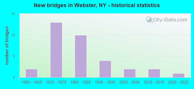
- New bridges - historical statistics
- 21960-1969
- 131970-1979
- 101980-1989
- 41990-1999
- 22000-2009
- 22010-2019
- 12020-2022


- Bridge Condition - Deck
- 5.6%Excellent
- 22.2%Very good
- 38.9%Good
- 16.7%Satisfactory
- 16.7%Fair

- Bridge Condition - Superstructure
- 9.5%Excellent
- 14.3%Very good
- 57.1%Good
- 14.3%Satisfactory
- 4.8%Fair

- Bridge Condition - Substructure
- 4.8%Excellent
- 14.3%Very good
- 47.6%Good
- 9.5%Satisfactory
- 19.0%Fair
- 4.8%Poor

- Bridge Condition - Channel
- 16.7%Very good
- 25.0%Good
- 33.3%Satisfactory
- 25.0%Fair

- Bridge Condition - Culverts
- 50.0%Very good
- 50.0%Good
Find on map >> Show street view
Structure Number: 1052129, Location: 2.9MI E JCT RTS 104+47 (Lat: 43.213781, Lng: -77.474989), Route carried "on" structure: County highway , Year Built: 1969, Status: Open, Structure Length: 7.53m (24.70ft), Average Daily Traffic: 9,462 (year 2020), Truck Traffic: 2%, Average Future Daily Traffic: 11,494 (year 2040), Design Load: HS 20, Features Intersected: 104 104 43035251 WB, RTE, Facility Carried by Structure: FIVE MILE LINE RD
Minimum Vertical Clearance: 30+ m (98+ ft), Kilometerpoint: 10.024, Lanes on structure: 5, Lanes under structure: 4, Owner: State Highway Agency, Approaching Roadway Width: 19.5m (64.0ft), Skew: 1 degrees, Material/Design: Steel, Design/Construction: Stringer/Multi-beam, Number Of Spans In Main Unit: 2, Length of Maximum Span: 36.5m (119.8ft), Curb or Sidewalk Widths: Left: 1.5m (4.9ft), Right: 1.5m (4.9ft), Curb-To-Curb Width: 19.5m (64.0ft), Out-to-Out Width: 23.3m (76.4ft)
Condition: Deck: Satisfactory, Superstructure: Good, Substructure: Poor, Operating Rating: 70.8 metric tons, Method Used To Determine Operating Rating: Load Factor (LF), Inventory Rating: 41.7 metric tons, Method Used To Determine Inventory Rating: Load Factor (LF), Structural Evaluation: Meets minimum limits, Deck Geometry: Meets minimum limits, Underclear: High priority of corrective action, Approach Roadway Alignment: Equal to present minimum criteria, Length Of Structure Improvement: 7.52m (24.67ft), Designated Inspection Frequency: Every 24 months, Inspection Date: June 2021, Bridge Improvement Cost: $4,463,000, Roadway Improvement Cost: $2,614,000, Total Project Cost: $7,077,000 ( Estimate for 2021), Deck Structure Type: Concrete Cast-file-Place, Wearing Surface/Protective System: Wearing Surface: Latex Concrete, Deck Protection: Other Coated Reinforcing
Find on map >> Show street view
Structure Number: 1068801, Location: IN WEBSTER (Lat: 43.215942, Lng: -77.430206), Route carried "on" structure: State highway 104, Year Built: 1976, Status: Open, Structure Length: 4.51m (14.80ft), Average Daily Traffic: 22,326 (year 2020), Truck Traffic: 4%, Average Future Daily Traffic: 23,288 (year 2040), Design Load: HS 20, Features Intersected: RTE 250
Minimum Vertical Clearance: 30+ m (98+ ft), Kilometerpoint: 48.672, Lanes on structure: 2, Lanes under structure: 6, Base Highway Network: Yes, Owner: State Highway Agency, Approaching Roadway Width: 12.8m (42.0ft), Material/Design: Steel, Design/Construction: Stringer/Multi-beam, Number Of Spans In Main Unit: 1, Length of Maximum Span: 44.1m (144.7ft), Curb-To-Curb Width: 12.6m (41.3ft), Out-to-Out Width: 13.6m (44.6ft)
Condition: Deck: Good, Superstructure: Good, Substructure: Fair, Operating Rating: 66.7 metric tons, Method Used To Determine Operating Rating: Load and Resistance Factor Rating (LRFR) rating reported by rating factor(RF) method using HL-93 loadings, Inventory Rating: 51.5 metric tons, Method Used To Determine Inventory Rating: Load and Resistance Factor Rating (LRFR) rating reported by rating factor(RF) method using HL-93 loadings, Structural Evaluation: Somewhat better than minimum adequacy, Deck Geometry: Better than present minimum criteria, Underclear: Meets minimum limits, Approach Roadway Alignment: Equal to present desirable criteria, Length Of Structure Improvement: 4.51m (14.80ft), Designated Inspection Frequency: Every 24 months, Inspection Date: September 2021, Bridge Improvement Cost: $1,699,000, Roadway Improvement Cost: $995,000, Total Project Cost: $2,693,000 ( Estimate for 2021), Deck Structure Type: Concrete Cast-file-Place, Wearing Surface/Protective System: Wearing Surface: Integral Concrete
Find on map >> Show street view
Structure Number: 1068802, Location: IN WEBSTER (Lat: 43.215717, Lng: -77.430214), Route carried "on" structure: State highway 104, Year Built: 1976, Status: Open, Structure Length: 4.57m (14.99ft), Average Daily Traffic: 22,326 (year 2020), Truck Traffic: 4%, Average Future Daily Traffic: 23,288 (year 2040), Design Load: HS 20, Features Intersected: RTE 250
Minimum Vertical Clearance: 30+ m (98+ ft), Kilometerpoint: 48.672, Lanes on structure: 2, Lanes under structure: 6, Base Highway Network: Yes, Owner: State Highway Agency, Approaching Roadway Width: 12.8m (42.0ft), Material/Design: Steel, Design/Construction: Stringer/Multi-beam, Number Of Spans In Main Unit: 1, Length of Maximum Span: 44.1m (144.7ft), Curb-To-Curb Width: 12.6m (41.3ft), Out-to-Out Width: 13.6m (44.6ft)
Condition: Deck: Good, Superstructure: Satisfactory, Substructure: Fair, Operating Rating: 66.7 metric tons, Method Used To Determine Operating Rating: Load and Resistance Factor Rating (LRFR) rating reported by rating factor(RF) method using HL-93 loadings, Inventory Rating: 51.5 metric tons, Method Used To Determine Inventory Rating: Load and Resistance Factor Rating (LRFR) rating reported by rating factor(RF) method using HL-93 loadings, Structural Evaluation: Somewhat better than minimum adequacy, Deck Geometry: Better than present minimum criteria, Underclear: Meets minimum limits, Approach Roadway Alignment: Equal to present desirable criteria, Length Of Structure Improvement: 4.57m (14.99ft), Designated Inspection Frequency: Every 24 months, Inspection Date: September 2021, Bridge Improvement Cost: $1,681,000, Roadway Improvement Cost: $984,000, Total Project Cost: $2,665,000 ( Estimate for 2021), Deck Structure Type: Concrete Cast-file-Place, Wearing Surface/Protective System: Wearing Surface: Integral Concrete
Find on map >> Show street view
Structure Number: 1068811, Location: 1.0 MI EAST OF WEBSTER (Lat: 43.218369, Lng: -77.419147), Route carried "on" structure: State highway 104, Year Built: 1976, Status: Open, Structure Length: 4.39m (14.40ft), Average Daily Traffic: 22,326 (year 2020), Truck Traffic: 5%, Average Future Daily Traffic: 23,288 (year 2040), Design Load: HS 20, Features Intersected: PHILLIPS ROAD
Minimum Vertical Clearance: 30+ m (98+ ft), Kilometerpoint: 49.622, Lanes on structure: 2, Lanes under structure: 5, Base Highway Network: Yes, Owner: State Highway Agency, Approaching Roadway Width: 12.8m (42.0ft), Skew: 2 degrees, Material/Design: Steel, Design/Construction: Stringer/Multi-beam, Number Of Spans In Main Unit: 1, Length of Maximum Span: 42.6m (139.8ft), Curb-To-Curb Width: 12.6m (41.3ft), Out-to-Out Width: 13.6m (44.6ft)
Condition: Deck: Good, Superstructure: Satisfactory, Substructure: Satisfactory, Operating Rating: 98.0 metric tons, Method Used To Determine Operating Rating: Load Factor (LF), Inventory Rating: 59.0 metric tons, Method Used To Determine Inventory Rating: Load Factor (LF), Structural Evaluation: Equal to present minimum criteria, Deck Geometry: Better than present minimum criteria, Underclear: Somewhat better than minimum adequacy, Approach Roadway Alignment: Equal to present desirable criteria, Length Of Structure Improvement: 4.38m (14.37ft), Designated Inspection Frequency: Every 24 months, Inspection Date: September 2021, Bridge Improvement Cost: $1,688,000, Roadway Improvement Cost: $989,000, Total Project Cost: $2,677,000 ( Estimate for 2021), Deck Structure Type: Concrete Cast-file-Place, Wearing Surface/Protective System: Wearing Surface: Integral Concrete
Find on map >> Show street view
Structure Number: 1068812, Location: 1.0 MI EAST OF WEBSTER (Lat: 43.218119, Lng: -77.419150), Route carried "on" structure: State highway 104, Year Built: 1976, Status: Open, Structure Length: 4.42m (14.50ft), Average Daily Traffic: 22,326 (year 2020), Truck Traffic: 4%, Average Future Daily Traffic: 23,288 (year 2040), Design Load: HS 20, Features Intersected: PHILLIPS ROAD-CR8
Minimum Vertical Clearance: 30+ m (98+ ft), Kilometerpoint: 49.622, Lanes on structure: 2, Lanes under structure: 5, Base Highway Network: Yes, Owner: State Highway Agency, Approaching Roadway Width: 12.8m (42.0ft), Skew: 2 degrees, Material/Design: Steel, Design/Construction: Stringer/Multi-beam, Number Of Spans In Main Unit: 1, Length of Maximum Span: 42.6m (139.8ft), Curb-To-Curb Width: 12.6m (41.3ft), Out-to-Out Width: 13.6m (44.6ft)
Condition: Deck: Very good, Superstructure: Satisfactory, Substructure: Fair, Operating Rating: 98.9 metric tons, Method Used To Determine Operating Rating: Load Factor (LF), Inventory Rating: 59.0 metric tons, Method Used To Determine Inventory Rating: Load Factor (LF), Structural Evaluation: Somewhat better than minimum adequacy, Deck Geometry: Better than present minimum criteria, Underclear: Somewhat better than minimum adequacy, Approach Roadway Alignment: Equal to present desirable criteria, Length Of Structure Improvement: 4.41m (14.47ft), Designated Inspection Frequency: Every 24 months, Inspection Date: September 2021, Bridge Improvement Cost: $1,679,000, Roadway Improvement Cost: $983,000, Total Project Cost: $2,662,000 ( Estimate for 2021), Deck Structure Type: Concrete Cast-file-Place, Wearing Surface/Protective System: Wearing Surface: Integral Concrete
Find on map >> Show street view
Structure Number: 1068821, Location: JCT S H 104 & COUNTY RD 6 (Lat: 43.220139, Lng: -77.400139), Route carried "on" structure: State highway 104, Year Built: 1976, Status: Open, Structure Length: 4.54m (14.90ft), Average Daily Traffic: 15,745 (year 2020), Truck Traffic: 5%, Average Future Daily Traffic: 16,423 (year 2040), Design Load: HS 20, Features Intersected: SALT ROAD
Minimum Vertical Clearance: 30+ m (98+ ft), Kilometerpoint: 51.182, Lanes on structure: 2, Lanes under structure: 6, Base Highway Network: Yes, Owner: State Highway Agency, Approaching Roadway Width: 11.0m (36.1ft), Material/Design: Steel, Design/Construction: Stringer/Multi-beam, Number Of Spans In Main Unit: 1, Length of Maximum Span: 44.1m (144.7ft), Curb-To-Curb Width: 12.6m (41.3ft), Out-to-Out Width: 13.6m (44.6ft)
Condition: Deck: Good, Superstructure: Good, Substructure: Satisfactory, Inventory Rating: 64.4 metric tons, Method Used To Determine Inventory Rating: Load Factor (LF), Structural Evaluation: Equal to present minimum criteria, Deck Geometry: Better than present minimum criteria, Underclear: Equal to present minimum criteria, Approach Roadway Alignment: Equal to present desirable criteria, Length Of Structure Improvement: 4.54m (14.90ft), Designated Inspection Frequency: Every 24 months, Inspection Date: August 2021, Bridge Improvement Cost: $1,722,000, Roadway Improvement Cost: $1,009,000, Total Project Cost: $2,731,000 ( Estimate for 2021), Deck Structure Type: Concrete Cast-file-Place, Wearing Surface/Protective System: Wearing Surface: Monolithic Concrete
Find on map >> Show street view
Structure Number: 1068822, Location: JCT S H 104 & COUNTY RD 6 (Lat: 43.219892, Lng: -77.400111), Route carried "on" structure: State highway 104, Year Built: 1976, Status: Open, Structure Length: 4.54m (14.90ft), Average Daily Traffic: 15,745 (year 2020), Truck Traffic: 5%, Average Future Daily Traffic: 16,423 (year 2040), Design Load: HS 20, Features Intersected: SALT ROAD
Minimum Vertical Clearance: 30+ m (98+ ft), Kilometerpoint: 51.182, Lanes on structure: 2, Lanes under structure: 6, Base Highway Network: Yes, Owner: State Highway Agency, Approaching Roadway Width: 11.0m (36.1ft), Material/Design: Steel, Design/Construction: Stringer/Multi-beam, Number Of Spans In Main Unit: 1, Length of Maximum Span: 44.1m (144.7ft), Curb-To-Curb Width: 12.6m (41.3ft), Out-to-Out Width: 13.6m (44.6ft)
Condition: Deck: Good, Superstructure: Very good, Substructure: Good, Operating Rating: 53.1 metric tons, Method Used To Determine Operating Rating: Load and Resistance Factor Rating (LRFR) rating reported by rating factor(RF) method using HL-93 loadings, Inventory Rating: 41.1 metric tons, Method Used To Determine Inventory Rating: Load and Resistance Factor Rating (LRFR) rating reported by rating factor(RF) method using HL-93 loadings, Structural Evaluation: Better than present minimum criteria, Deck Geometry: Better than present minimum criteria, Underclear: Equal to present minimum criteria, Approach Roadway Alignment: Equal to present desirable criteria, Length Of Structure Improvement: 4.54m (14.90ft), Designated Inspection Frequency: Every 24 months, Inspection Date: June 2021, Bridge Improvement Cost: $1,705,000, Roadway Improvement Cost: $998,000, Total Project Cost: $2,703,000 ( Estimate for 2021), Deck Structure Type: Concrete Cast-file-Place, Wearing Surface/Protective System: Wearing Surface: Monolithic Concrete
Find on map >> Show street view
Structure Number: 1073451, Location: 1.6MI W RTES 250 & 104 WB (Lat: 43.214269, Lng: -77.461244), Route carried "on" structure: State highway 104, Year Built: 1986, Status: Open, Structure Length: 4.71m (15.45ft), Average Daily Traffic: 26,086 (year 2020), Truck Traffic: 4%, Average Future Daily Traffic: 27,210 (year 2040), Design Load: HS 20, Features Intersected: HARD ROAD
Minimum Vertical Clearance: 30+ m (98+ ft), Kilometerpoint: 46.130, Lanes on structure: 2, Lanes under structure: 5, Base Highway Network: Yes, Owner: State Highway Agency, Approaching Roadway Width: 11.6m (38.1ft), Material/Design: Steel, Design/Construction: Stringer/Multi-beam, Number Of Spans In Main Unit: 1, Length of Maximum Span: 45.7m (149.9ft), Curb-To-Curb Width: 11.9m (39.0ft), Out-to-Out Width: 12.8m (42.0ft)
Condition: Deck: Fair, Superstructure: Good, Substructure: Good, Operating Rating: 93.4 metric tons, Method Used To Determine Operating Rating: Load Factor (LF), Inventory Rating: 56.2 metric tons, Method Used To Determine Inventory Rating: Load Factor (LF), Structural Evaluation: Better than present minimum criteria, Deck Geometry: Equal to present minimum criteria, Underclear: Meets minimum limits, Approach Roadway Alignment: Equal to present desirable criteria, Length Of Structure Improvement: 4.71m (15.45ft), Designated Inspection Frequency: Every 24 months, Inspection Date: October 2020, Bridge Improvement Cost: $1,660,000, Roadway Improvement Cost: $972,000, Total Project Cost: $2,632,000 ( Estimate for 2021), Deck Structure Type: Concrete Cast-file-Place, Wearing Surface/Protective System: Wearing Surface: Bituminous, Deck Protection: Epoxy Coated Reinforcing
Find on map >> Show street view
Structure Number: 1073452, Location: 1.6MI W RTES 250 & 104 EB (Lat: 43.214097, Lng: -77.461242), Route carried "on" structure: State highway 104, Year Built: 1986, Status: Open, Structure Length: 4.71m (15.45ft), Average Daily Traffic: 26,086 (year 2020), Truck Traffic: 4%, Average Future Daily Traffic: 27,210 (year 2040), Design Load: HS 20, Features Intersected: HARD ROAD
Minimum Vertical Clearance: 30+ m (98+ ft), Kilometerpoint: 46.130, Lanes on structure: 2, Lanes under structure: 5, Base Highway Network: Yes, Owner: State Highway Agency, Approaching Roadway Width: 11.6m (38.1ft), Material/Design: Steel, Design/Construction: Stringer/Multi-beam, Number Of Spans In Main Unit: 1, Length of Maximum Span: 45.7m (149.9ft), Curb-To-Curb Width: 11.9m (39.0ft), Out-to-Out Width: 12.8m (42.0ft)
Condition: Deck: Fair, Superstructure: Good, Substructure: Good, Operating Rating: 99.8 metric tons, Method Used To Determine Operating Rating: Load Factor (LF), Inventory Rating: 59.0 metric tons, Method Used To Determine Inventory Rating: Load Factor (LF), Structural Evaluation: Better than present minimum criteria, Deck Geometry: Equal to present minimum criteria, Underclear: Meets minimum limits, Approach Roadway Alignment: Equal to present desirable criteria, Length Of Structure Improvement: 4.71m (15.45ft), Designated Inspection Frequency: Every 24 months, Inspection Date: October 2020, Bridge Improvement Cost: $1,676,000, Roadway Improvement Cost: $982,000, Total Project Cost: $2,658,000 ( Estimate for 2021), Deck Structure Type: Concrete Cast-file-Place, Wearing Surface/Protective System: Wearing Surface: Bituminous, Deck Protection: Epoxy Coated Reinforcing
Find on map >> Show street view
Structure Number: 1073461, Location: 0.9MI W RTES 250 & 104 WB (Lat: 43.215650, Lng: -77.446594), Route carried "on" structure: State highway 104, Year Built: 1986, Status: Open, Structure Length: 4.42m (14.50ft), Average Daily Traffic: 26,086 (year 2020), Truck Traffic: 4%, Average Future Daily Traffic: 27,210 (year 2040), Design Load: HS 20, Features Intersected: HOLT ROAD
Minimum Vertical Clearance: 30+ m (98+ ft), Kilometerpoint: 47.337, Lanes on structure: 2, Lanes under structure: 5, Base Highway Network: Yes, Owner: State Highway Agency, Approaching Roadway Width: 11.6m (38.1ft), Material/Design: Steel, Design/Construction: Stringer/Multi-beam, Number Of Spans In Main Unit: 1, Length of Maximum Span: 42.6m (139.8ft), Curb-To-Curb Width: 11.9m (39.0ft), Out-to-Out Width: 12.8m (42.0ft)
Condition: Deck: Satisfactory, Superstructure: Good, Substructure: Good, Operating Rating: 98.0 metric tons, Method Used To Determine Operating Rating: Load Factor (LF), Inventory Rating: 58.1 metric tons, Method Used To Determine Inventory Rating: Load Factor (LF), Structural Evaluation: Better than present minimum criteria, Deck Geometry: Equal to present minimum criteria, Underclear: Meets minimum limits, Approach Roadway Alignment: Equal to present desirable criteria, Length Of Structure Improvement: 4.41m (14.47ft), Designated Inspection Frequency: Every 24 months, Inspection Date: May 2020, Bridge Improvement Cost: $1,576,000, Roadway Improvement Cost: $923,000, Total Project Cost: $2,500,000 ( Estimate for 2021), Deck Structure Type: Concrete Cast-file-Place, Wearing Surface/Protective System: Wearing Surface: Bituminous, Deck Protection: Epoxy Coated Reinforcing
Find on map >> Show street view
Structure Number: 1073462, Location: 0.9MI W RTES 250 & 104 EB (Lat: 43.215414, Lng: -77.446586), Route carried "on" structure: State highway 104, Year Built: 1986, Status: Open, Structure Length: 4.42m (14.50ft), Average Daily Traffic: 26,086 (year 2020), Truck Traffic: 4%, Average Future Daily Traffic: 27,210 (year 2040), Design Load: HS 20, Features Intersected: HOLT ROAD
Minimum Vertical Clearance: 30+ m (98+ ft), Kilometerpoint: 47.337, Lanes on structure: 2, Lanes under structure: 5, Base Highway Network: Yes, Owner: State Highway Agency, Approaching Roadway Width: 11.6m (38.1ft), Material/Design: Steel, Design/Construction: Stringer/Multi-beam, Number Of Spans In Main Unit: 1, Length of Maximum Span: 42.6m (139.8ft), Curb-To-Curb Width: 11.9m (39.0ft), Out-to-Out Width: 12.8m (42.0ft)
Condition: Deck: Satisfactory, Superstructure: Good, Substructure: Good, Operating Rating: 98.0 metric tons, Method Used To Determine Operating Rating: Load Factor (LF), Inventory Rating: 58.1 metric tons, Method Used To Determine Inventory Rating: Load Factor (LF), Structural Evaluation: Better than present minimum criteria, Deck Geometry: Equal to present minimum criteria, Underclear: Meets minimum limits, Approach Roadway Alignment: Equal to present desirable criteria, Length Of Structure Improvement: 4.41m (14.47ft), Designated Inspection Frequency: Every 24 months, Inspection Date: May 2020, Bridge Improvement Cost: $1,576,000, Roadway Improvement Cost: $923,000, Total Project Cost: $2,500,000 ( Estimate for 2021), Deck Structure Type: Concrete Cast-file-Place, Wearing Surface/Protective System: Wearing Surface: Bituminous, Deck Protection: Epoxy Coated Reinforcing
Find on map >> Show street view
Structure Number: 10957, Location: 0.9MI W JCT RTS 18 + 250 (Lat: 43.259656, Lng: -77.450856), Route carried "on" structure: Other road 941L, Year Built: 1971, Status: Open, Structure Length: 1.43m (4.69ft), Average Daily Traffic: 1,696 (year 2018), Truck Traffic: 2%, Average Future Daily Traffic: 2,098 (year 2040), Design Load: HS 20, Features Intersected: MILL CREEK, SIDEWALK
Minimum Vertical Clearance: 30+ m (98+ ft), Kilometerpoint: 7.562, Lanes on structure: 2, Owner: County Highway Agency, Approaching Roadway Width: 11.0m (36.1ft), Skew: 1 degrees, Material/Design: Prestressed concrete, Design/Construction: Box Beam or Girders - Multiple, Number Of Spans In Main Unit: 1, Length of Maximum Span: 12.8m (42.0ft), Curb-To-Curb Width: 11.1m (36.4ft), Out-to-Out Width: 12.2m (40.0ft)
Condition: Deck: Good, Superstructure: Good, Substructure: Good, Channel: Good, Operating Rating: 53.1 metric tons, Method Used To Determine Operating Rating: Load and Resistance Factor Rating (LRFR) rating reported by rating factor(RF) method using HL-93 loadings, Inventory Rating: 37.9 metric tons, Method Used To Determine Inventory Rating: Load and Resistance Factor Rating (LRFR) rating reported by rating factor(RF) method using HL-93 loadings, Structural Evaluation: Better than present minimum criteria, Deck Geometry: Equal to present minimum criteria, Waterway Adequacy: Equal to present minimum criteria, Approach Roadway Alignment: Equal to present desirable criteria, Length Of Structure Improvement: 1.43m (4.69ft), Designated Inspection Frequency: Every 24 months, Inspection Date: August 2021, Bridge Improvement Cost: $638,000, Roadway Improvement Cost: $374,000, Total Project Cost: $1,012,000 ( Estimate for 2021), Deck Structure Type: Concrete Cast-file-Place, Wearing Surface/Protective System: Wearing Surface: Bituminous, Membrane: Other
Find on map >> Show street view
Structure Number: 221122, Location: 3.6 MI NE OF WEBSTER (Lat: 43.252953, Lng: -77.386925), Route carried "on" structure: Other road , Year Built: 1997, Status: Open, Structure Length: 0.98m (3.22ft), Average Daily Traffic: 243 (year 2016), Truck Traffic: 3%, Average Future Daily Traffic: 340 (year 2036), Design Load: HS 25 or greater, Features Intersected: FOUR MILE CREEK, Facility Carried by Structure: WOODARD ROAD
Minimum Vertical Clearance: 30+ m (98+ ft), Kilometerpoint: 1.126, Lanes on structure: 2, Owner: County Highway Agency, Approaching Roadway Width: 10.1m (33.1ft), Material/Design: Concrete, Design/Construction: Frame, Number Of Spans In Main Unit: 1, Length of Maximum Span: 9.1m (29.9ft), Curb-To-Curb Width: 10.1m (33.1ft), Out-to-Out Width: 11.3m (37.1ft)
Condition: Superstructure: Excellent, Substructure: Good, Channel: Satisfactory, Operating Rating: 79.1 metric tons, Method Used To Determine Operating Rating: Field evaluation and documented engineering judgment, Inventory Rating: 40.8 metric tons, Method Used To Determine Inventory Rating: Field evaluation and documented engineering judgment, Structural Evaluation: Better than present minimum criteria, Deck Geometry: Better than present minimum criteria, Waterway Adequacy: Better than present minimum criteria, Approach Roadway Alignment: Equal to present desirable criteria, Length Of Structure Improvement: 0.97m (3.18ft), Designated Inspection Frequency: Every 24 months, Inspection Date: May 2021, Bridge Improvement Cost: $345,000, Roadway Improvement Cost: $202,000, Total Project Cost: $547,000 ( Estimate for 2021), Wearing Surface/Protective System: Wearing Surface: Bituminous, Membrane: Other
Find on map >> Show street view
Structure Number: 227181, Location: 1 MI E OF 250-STATE RD IN (Lat: 43.204417, Lng: -77.410686), Route carried "on" structure: Other road , Year Built: 2016, Status: Posted for load, Structure Length: 0.88m (2.89ft), Design Load: HS 20, Features Intersected: ARBOR CREEK, Facility Carried by Structure: CREEK FIELD DRIVE
Minimum Vertical Clearance: 32.69m (107.25ft), Kilometerpoint: 0.064, Lanes on structure: 2, Owner: Town or Township Highway Agency, Approaching Roadway Width: 6.1m (20.0ft), Material/Design: Prestressed concrete, Design/Construction: Box Beam or Girders - Multiple, Number Of Spans In Main Unit: 1, Length of Maximum Span: 8.5m (27.9ft), Curb or Sidewalk Widths: Left: 2.6m (8.5ft), Right: 2.6m (8.5ft), Curb-To-Curb Width: 7.7m (25.3ft), Out-to-Out Width: 13.7m (44.9ft)
Condition: Deck: Fair, Superstructure: Fair, Substructure: Good, Channel: Good, Operating Rating: 3.6 metric tons, Method Used To Determine Operating Rating: Field evaluation and documented engineering judgment, Inventory Rating: 3.6 metric tons, Method Used To Determine Inventory Rating: Field evaluation and documented engineering judgment, Structural Evaluation: High priority of corrective action, Deck Geometry: Equal to present minimum criteria, Waterway Adequacy: Better than present minimum criteria, Approach Roadway Alignment: Equal to present minimum criteria, Bridge Posting: Required (Relationship of Operating Rating to Maximum Legal Load: > 39.9% below), Designated Inspection Frequency: Every 12 months, Inspection Date: August 2021, Wearing Surface/Protective System: Wearing Surface: Monolithic Concrete
Find on map >> Show street view
Structure Number: 331733, Location: 4 MI NE OF WEBSTER (Lat: 43.260589, Lng: -77.388175), Route carried "on" structure: County highway , Year Built: 2006, Status: Open, Structure Length: 1.92m (6.30ft), Average Daily Traffic: 564 (year 2016), Truck Traffic: 5%, Average Future Daily Traffic: 790 (year 2036), Design Load: HS 25 or greater, Features Intersected: FOUR MILE CREEK, Facility Carried by Structure: BASKET ROAD
Minimum Vertical Clearance: 30+ m (98+ ft), Kilometerpoint: 4.376, Lanes on structure: 2, Owner: County Highway Agency, Approaching Roadway Width: 5.8m (19.0ft), Skew: 4 degrees, Material/Design: Prestressed concrete, Design/Construction: Box Beam or Girders - Multiple, Number Of Spans In Main Unit: 1, Length of Maximum Span: 16.5m (54.1ft), Curb-To-Curb Width: 10.3m (33.8ft), Out-to-Out Width: 11.3m (37.1ft)
Condition: Deck: Very good, Superstructure: Very good, Substructure: Very good, Channel: Very good, Operating Rating: 55.1 metric tons, Method Used To Determine Operating Rating: Load and Resistance Factor Rating (LRFR) rating reported by rating factor(RF) method using HL-93 loadings, Inventory Rating: 42.4 metric tons, Method Used To Determine Inventory Rating: Load and Resistance Factor Rating (LRFR) rating reported by rating factor(RF) method using HL-93 loadings, Structural Evaluation: Equal to present desirable criteria, Deck Geometry: Equal to present minimum criteria, Waterway Adequacy: Equal to present desirable criteria, Approach Roadway Alignment: Better than present minimum criteria, Length Of Structure Improvement: 1.92m (6.30ft), Designated Inspection Frequency: Every 24 months, Inspection Date: November 2020, Bridge Improvement Cost: $623,000, Roadway Improvement Cost: $365,000, Total Project Cost: $988,000 ( Estimate for 2021), Wearing Surface/Protective System: Wearing Surface: Integral Concrete
Find on map >> Show street view
Structure Number: 331734, Location: 3.3 MI N.E. OF WEBSTER (Lat: 43.237533, Lng: -77.375986), Route carried "on" structure: ServiceCounty highway , Year Built: 1984, Status: Open, Structure Length: 0.88m (2.89ft), Average Daily Traffic: 1,979 (year 2018), Truck Traffic: 7%, Average Future Daily Traffic: 2,448 (year 2040), Design Load: HS 20+Mod, Features Intersected: FOUR MILE CREEK, Facility Carried by Structure: MON-WYN CO LNE RD
Minimum Vertical Clearance: 30+ m (98+ ft), Kilometerpoint: 1.625, Lanes on structure: 2, Owner: County Highway Agency, Approaching Roadway Width: 12.2m (40.0ft), Skew: 2 degrees, Material/Design: Prestressed concrete, Design/Construction: Box Beam or Girders - Multiple, Number Of Spans In Main Unit: 1, Length of Maximum Span: 8.5m (27.9ft), Curb-To-Curb Width: 12.2m (40.0ft), Out-to-Out Width: 12.8m (42.0ft)
Condition: Deck: Good, Superstructure: Good, Substructure: Fair, Channel: Fair, Operating Rating: 61.7 metric tons, Method Used To Determine Operating Rating: Load Factor (LF), Inventory Rating: 37.2 metric tons, Method Used To Determine Inventory Rating: Load Factor (LF), Structural Evaluation: Somewhat better than minimum adequacy, Deck Geometry: Better than present minimum criteria, Waterway Adequacy: Equal to present desirable criteria, Approach Roadway Alignment: Equal to present desirable criteria, Length Of Structure Improvement: 0.88m (2.89ft), Designated Inspection Frequency: Every 24 months, Inspection Date: April 2020, Bridge Improvement Cost: $360,000, Roadway Improvement Cost: $211,000, Total Project Cost: $571,000 ( Estimate for 2021), Wearing Surface/Protective System: Wearing Surface: Bituminous, Membrane: Other
Find on map >> Show street view
Structure Number: 331735, Location: 3.4 MI NE OF WEBSTER (Lat: 43.240808, Lng: -77.377453), Route carried "on" structure: County highway , Year Built: 1999, Status: Open, Structure Length: 0.98m (3.22ft), Average Daily Traffic: 1,064 (year 2018), Truck Traffic: 2%, Average Future Daily Traffic: 1,316 (year 2040), Design Load: HS 25 or greater, Features Intersected: FOUR MILE CREEK, Facility Carried by Structure: SCHLEGEL ROAD
Minimum Vertical Clearance: 30+ m (98+ ft), Kilometerpoint: 4.167, Lanes on structure: 2, Owner: County Highway Agency, Approaching Roadway Width: 5.5m (18.0ft), Material/Design: Concrete, Design/Construction: Frame, Number Of Spans In Main Unit: 1, Length of Maximum Span: 9.1m (29.9ft), Curb-To-Curb Width: 9.6m (31.5ft), Out-to-Out Width: 10.6m (34.8ft)
Condition: Deck: Very good, Superstructure: Good, Substructure: Very good, Channel: Fair, Operating Rating: 79.1 metric tons, Method Used To Determine Operating Rating: Field evaluation and documented engineering judgment, Inventory Rating: 40.8 metric tons, Method Used To Determine Inventory Rating: Field evaluation and documented engineering judgment, Structural Evaluation: Better than present minimum criteria, Deck Geometry: Somewhat better than minimum adequacy, Waterway Adequacy: Somewhat better than minimum adequacy, Approach Roadway Alignment: Equal to present desirable criteria, Length Of Structure Improvement: 0.97m (3.18ft), Designated Inspection Frequency: Every 24 months, Inspection Date: May 2021, Bridge Improvement Cost: $302,000, Roadway Improvement Cost: $177,000, Total Project Cost: $479,000 ( Estimate for 2021), Wearing Surface/Protective System: Wearing Surface: Bituminous, Membrane: Other
Find on map >> Show street view
Structure Number: 33179, Location: 3.8 MI NE OF WEBSTER (Lat: 43.264903, Lng: -77.400872), Route carried "on" structure: County highway , Year Built: 2020, Status: Open, Structure Length: 1.52m (4.99ft), Average Daily Traffic: 697 (year 2020), Truck Traffic: 10%, Average Future Daily Traffic: 862 (year 2040), Features Intersected: FOURMILE CREEK, Facility Carried by Structure: SALT ROAD
Minimum Vertical Clearance: 30+ m (98+ ft), Kilometerpoint: 14.915, Lanes on structure: 2, Owner: County Highway Agency, Approaching Roadway Width: 9.1m (29.9ft), Material/Design: Steel, Design/Construction: Stringer/Multi-beam, Number Of Spans In Main Unit: 1, Length of Maximum Span: 14.0m (45.9ft), Curb-To-Curb Width: 10.6m (34.8ft), Out-to-Out Width: 11.8m (38.7ft)
Condition: Deck: Excellent, Superstructure: Excellent, Substructure: Excellent, Channel: Satisfactory, Operating Rating: 33.6 metric tons, Method Used To Determine Operating Rating: Load Factor (LF), Inventory Rating: 20.0 metric tons, Method Used To Determine Inventory Rating: Load Factor (LF), Structural Evaluation: Somewhat better than minimum adequacy, Deck Geometry: Equal to present minimum criteria, Waterway Adequacy: Meets minimum limits, Approach Roadway Alignment: Equal to present desirable criteria, Length Of Structure Improvement: 1.52m (4.99ft), Designated Inspection Frequency: Every 24 months, Inspection Date: November 2020, Bridge Improvement Cost: $527,000, Roadway Improvement Cost: $309,000, Total Project Cost: $835,000 ( Estimate for 2021), Deck Structure Type: Concrete Cast-file-Place, Wearing Surface/Protective System: Wearing Surface: Integral Concrete
Find on map >> Show street view
Structure Number: 336162, Location: 4 MI N OF WEBSTER (Lat: 43.265703, Lng: -77.418364), Route carried "on" structure: County highway , Year Built: 2004, Status: Open, Structure Length: 1.13m (3.71ft), Average Daily Traffic: 3,074 (year 2020), Truck Traffic: 5%, Average Future Daily Traffic: 3,803 (year 2040), Design Load: HS 25 or greater, Features Intersected: FOUR MILE CREEK, Facility Carried by Structure: LAKE ROAD
Minimum Vertical Clearance: 30+ m (98+ ft), Kilometerpoint: 10.330, Lanes on structure: 2, Owner: County Highway Agency, Approaching Roadway Width: 10.1m (33.1ft), Skew: 1 degrees, Material/Design: Concrete, Design/Construction: Culvert, Number Of Spans In Main Unit: 1, Length of Maximum Span: 11.0m (36.1ft), Curb-To-Curb Width: 10.2m (33.5ft), Out-to-Out Width: 15.6m (51.2ft)
Condition: Channel: Very good, Culverts: Very good, Operating Rating: 80.4 metric tons, Method Used To Determine Operating Rating: Field evaluation and documented engineering judgment, Inventory Rating: 40.8 metric tons, Method Used To Determine Inventory Rating: Field evaluation and documented engineering judgment, Structural Evaluation: Equal to present desirable criteria, Deck Geometry: Meets minimum limits, Waterway Adequacy: Superior to present desirable criteria, Approach Roadway Alignment: Equal to present desirable criteria, Length Of Structure Improvement: 1.12m (3.67ft), Designated Inspection Frequency: Every 24 months, Inspection Date: March 2021, Bridge Improvement Cost: $316,000, Roadway Improvement Cost: $185,000, Total Project Cost: $502,000 ( Estimate for 2021)
Find on map >> Show street view
Structure Number: 33681, Location: 2.9 MILES EAST OF WEBSTER (Lat: 43.225700, Lng: -77.375347), Route carried "on" structure: County highway , Year Built: 1989, Status: Open, Structure Length: 1.19m (3.90ft), Average Daily Traffic: 1,979 (year 2018), Truck Traffic: 7%, Average Future Daily Traffic: 2,448 (year 2040), Design Load: HS 20, Features Intersected: FOUR MILE CREEK, Facility Carried by Structure: MONROE-WNE C.L.RD
Minimum Vertical Clearance: 30+ m (98+ ft), Kilometerpoint: 0.306, Lanes on structure: 2, Owner: County Highway Agency, Approaching Roadway Width: 9.4m (30.8ft), Material/Design: Prestressed concrete, Design/Construction: Box Beam or Girders - Multiple, Number Of Spans In Main Unit: 1, Length of Maximum Span: 11.2m (36.7ft), Curb-To-Curb Width: 12.3m (40.4ft), Out-to-Out Width: 13.0m (42.7ft)
Condition: Deck: Very good, Superstructure: Good, Substructure: Good, Channel: Fair, Operating Rating: 69.9 metric tons, Method Used To Determine Operating Rating: Load Factor (LF), Inventory Rating: 41.7 metric tons, Method Used To Determine Inventory Rating: Load Factor (LF), Structural Evaluation: Better than present minimum criteria, Deck Geometry: Better than present minimum criteria, Waterway Adequacy: Equal to present minimum criteria, Approach Roadway Alignment: Equal to present desirable criteria, Length Of Structure Improvement: 1.18m (3.87ft), Designated Inspection Frequency: Every 24 months, Inspection Date: April 2021, Bridge Improvement Cost: $438,000, Roadway Improvement Cost: $257,000, Total Project Cost: $695,000 ( Estimate for 2021), Wearing Surface/Protective System: Wearing Surface: Bituminous, Membrane: Other
Find on map >> Show street view
Structure Number: 336944, Location: 2.5 MI NE OF WEBSTER (Lat: 43.251872, Lng: -77.387969), Route carried "on" structure: County highway , Year Built: 1998, Status: Open, Structure Length: 0.91m (2.99ft), Average Daily Traffic: 564 (year 2016), Truck Traffic: 5%, Average Future Daily Traffic: 790 (year 2036), Features Intersected: FOUR MILE CREEK, Facility Carried by Structure: BASKET ROAD
Minimum Vertical Clearance: 30+ m (98+ ft), Kilometerpoint: 3.395, Lanes on structure: 2, Owner: County Highway Agency, Approaching Roadway Width: 10.4m (34.1ft), Skew: 1 degrees, Material/Design: Concrete, Design/Construction: Culvert, Number Of Spans In Main Unit: 1, Length of Maximum Span: 8.8m (28.9ft), Curb-To-Curb Width: 10.4m (34.1ft), Out-to-Out Width: 13.4m (44.0ft)
Condition: Channel: Satisfactory, Culverts: Good, Operating Rating: 78.8 metric tons, Method Used To Determine Operating Rating: Field evaluation and documented engineering judgment, Inventory Rating: 40.8 metric tons, Method Used To Determine Inventory Rating: Field evaluation and documented engineering judgment, Structural Evaluation: Better than present minimum criteria, Deck Geometry: Equal to present minimum criteria, Waterway Adequacy: Equal to present desirable criteria, Approach Roadway Alignment: Equal to present desirable criteria, Length Of Structure Improvement: 0.91m (2.99ft), Designated Inspection Frequency: Every 24 months, Inspection Date: April 2020, Bridge Improvement Cost: $220,000, Roadway Improvement Cost: $129,000, Total Project Cost: $348,000 ( Estimate for 2021), Wearing Surface/Protective System: Wearing Surface: Bituminous
Find on map >> Show street view
Structure Number: 336945, Location: 2.5 MI NE OF WEBSTER (Lat: 43.250819, Lng: -77.387942), Route carried "on" structure: County highway , Year Built: 1998, Status: Open, Structure Length: 0.91m (2.99ft), Average Daily Traffic: 564 (year 2016), Truck Traffic: 5%, Average Future Daily Traffic: 790 (year 2036), Features Intersected: FOUR MILE CREEK, Facility Carried by Structure: BASKET ROAD
Minimum Vertical Clearance: 30+ m (98+ ft), Kilometerpoint: 3.282, Lanes on structure: 2, Owner: County Highway Agency, Approaching Roadway Width: 10.4m (34.1ft), Skew: 1 degrees, Material/Design: Concrete, Design/Construction: Frame, Number Of Spans In Main Unit: 1, Length of Maximum Span: 8.8m (28.9ft), Curb-To-Curb Width: 10.4m (34.1ft), Out-to-Out Width: 14.6m (47.9ft)
Condition: Superstructure: Good, Substructure: Good, Channel: Good, Operating Rating: 78.8 metric tons, Method Used To Determine Operating Rating: Field evaluation and documented engineering judgment, Inventory Rating: 40.8 metric tons, Method Used To Determine Inventory Rating: Field evaluation and documented engineering judgment, Structural Evaluation: Better than present minimum criteria, Deck Geometry: Equal to present minimum criteria, Waterway Adequacy: Equal to present desirable criteria, Approach Roadway Alignment: Equal to present desirable criteria, Length Of Structure Improvement: 0.91m (2.99ft), Designated Inspection Frequency: Every 24 months, Inspection Date: April 2020, Bridge Improvement Cost: $240,000, Roadway Improvement Cost: $140,000, Total Project Cost: $380,000 ( Estimate for 2021), Wearing Surface/Protective System: Wearing Surface: Bituminous
Find on map >> Show street view
Structure Number: 3371, Location: 0.2mi S of Salt Rd + Rt 1 (Lat: 43.217603, Lng: -77.400000), Route carried "on" structure: County highway , Year Built: 2013, Status: Open, Structure Length: 1.04m (3.41ft), Average Daily Traffic: 3,120 (year 2018), Truck Traffic: 6%, Average Future Daily Traffic: 3,790 (year 2040), Design Load: HL 93, Features Intersected: Four Mile Creek Trib., Facility Carried by Structure: CR 6
Minimum Vertical Clearance: 30+ m (98+ ft), Kilometerpoint: 9.670, Lanes on structure: 2, Owner: County Highway Agency, Approaching Roadway Width: 10.7m (35.1ft), Material/Design: Concrete, Design/Construction: Frame, Number Of Spans In Main Unit: 1, Length of Maximum Span: 9.8m (32.2ft), Curb-To-Curb Width: 10.7m (35.1ft), Out-to-Out Width: 11.6m (38.1ft)
Condition: Superstructure: Very good, Substructure: Very good, Channel: Satisfactory, Operating Rating: 79.5 metric tons, Method Used To Determine Operating Rating: Field evaluation and documented engineering judgment, Inventory Rating: 40.8 metric tons, Method Used To Determine Inventory Rating: Field evaluation and documented engineering judgment, Structural Evaluation: Equal to present desirable criteria, Deck Geometry: Somewhat better than minimum adequacy, Waterway Adequacy: Somewhat better than minimum adequacy, Approach Roadway Alignment: Equal to present desirable criteria, Length Of Structure Improvement: 1.03m (3.38ft), Designated Inspection Frequency: Every 24 months, Inspection Date: December 2021, Bridge Improvement Cost: $216,000, Roadway Improvement Cost: $126,000, Total Project Cost: $342,000 ( Estimate for 2021)
Find on map >> Show street view
Structure Number: 1052129, Location: 2.9MI E JCT RTS 104+47 (Lat: 43.213781, Lng: -77.474989), Route carried "under" structure: Interstate 104, Year Built: 1969, Structure Length: 0. m, Average Daily Traffic: 56,000 (year 1971), Features Intersected: 104 104 43035251 WB, RTE, Facility Carried by Structure: FIVE MILE LINE RD
Minimum Vertical Clearance: 4.45m (14.60ft), Kilometerpoint: 8.431, Lanes on structure: 5, Lanes under structure: 2, Material/Design: Steel, Design/Construction: Stringer/Multi-beam, Length of Maximum Span: 36.5m (119.8ft)
Find on map >> Show street view
Structure Number: 1068801, Location: IN WEBSTER (Lat: 43.215942, Lng: -77.430206), Route carried "under" structure: State highway 250, Year Built: 1976, Structure Length: 0. m, Average Daily Traffic: 12,022 (year 2009), Features Intersected: RTE 250, Facility Carried by Structure: RTE 104
Minimum Vertical Clearance: 4.85m (15.91ft), Kilometerpoint: 20.032, Lanes on structure: 2, Lanes under structure: 6, Material/Design: Steel, Design/Construction: Stringer/Multi-beam, Length of Maximum Span: 44.1m (144.7ft)
Find on map >> Show street view
Structure Number: 1068802, Location: IN WEBSTER (Lat: 43.215717, Lng: -77.430214), Route carried "under" structure: State highway 250, Year Built: 1976, Structure Length: 0. m, Average Daily Traffic: 12,022 (year 2009), Features Intersected: RTE 250, Facility Carried by Structure: RTE 104
Minimum Vertical Clearance: 4.55m (14.93ft), Kilometerpoint: 20.032, Lanes on structure: 2, Lanes under structure: 6, Material/Design: Steel, Design/Construction: Stringer/Multi-beam, Length of Maximum Span: 44.1m (144.7ft)
Find on map >> Show street view
Structure Number: 1068811, Location: 1.0 MI EAST OF WEBSTER (Lat: 43.218369, Lng: -77.419147), Route carried "under" structure: Bypass County highway , Year Built: 1976, Structure Length: 0. m, Average Daily Traffic: 3,023 (year 2019), Truck Traffic: 3%, Features Intersected: PHILLIPS ROAD, Facility Carried by Structure: RTE 104
Minimum Vertical Clearance: 4.85m (15.91ft), Kilometerpoint: 1.963, Lanes on structure: 2, Lanes under structure: 5, Material/Design: Steel, Design/Construction: Stringer/Multi-beam, Length of Maximum Span: 42.6m (139.8ft)
Find on map >> Show street view
Structure Number: 1068812, Location: 1.0 MI EAST OF WEBSTER (Lat: 43.218119, Lng: -77.419150), Route carried "under" structure: Bypass County highway , Year Built: 1976, Structure Length: 0. m, Average Daily Traffic: 3,023 (year 2019), Truck Traffic: 3%, Features Intersected: PHILLIPS ROAD-CR8, Facility Carried by Structure: RTE 104
Minimum Vertical Clearance: 4.65m (15.26ft), Kilometerpoint: 1.979, Lanes on structure: 2, Lanes under structure: 5, Material/Design: Steel, Design/Construction: Stringer/Multi-beam, Length of Maximum Span: 42.6m (139.8ft)
Find on map >> Show street view
Structure Number: 1068821, Location: JCT S H 104 & COUNTY RD 6 (Lat: 43.220139, Lng: -77.400139), Route carried "under" structure: Bypass County highway , Year Built: 1976, Structure Length: 0. m, Average Daily Traffic: 7,011 (year 2009), Features Intersected: SALT ROAD, Facility Carried by Structure: RTE 104
Minimum Vertical Clearance: 4.67m (15.32ft), Kilometerpoint: 0.000, Lanes on structure: 2, Lanes under structure: 6, Material/Design: Steel, Design/Construction: Stringer/Multi-beam, Length of Maximum Span: 44.1m (144.7ft)
Find on map >> Show street view
Structure Number: 1068822, Location: JCT S H 104 & COUNTY RD 6 (Lat: 43.219892, Lng: -77.400111), Route carried "under" structure: Bypass County highway , Year Built: 1976, Structure Length: 0. m, Average Daily Traffic: 7,011 (year 2009), Features Intersected: SALT ROAD, Facility Carried by Structure: RTE 104
Minimum Vertical Clearance: 4.57m (14.99ft), Kilometerpoint: 0.000, Lanes on structure: 2, Lanes under structure: 6, Material/Design: Steel, Design/Construction: Stringer/Multi-beam, Length of Maximum Span: 44.1m (144.7ft)
Find on map >> Show street view
Structure Number: 1073451, Location: 1.6MI W RTES 250 & 104 WB (Lat: 43.214269, Lng: -77.461244), Route carried "under" structure: Other road , Year Built: 1986, Structure Length: 0. m, Features Intersected: HARD ROAD, Facility Carried by Structure: RTE 104
Minimum Vertical Clearance: 4.70m (15.42ft), Kilometerpoint: 2.590, Lanes on structure: 2, Lanes under structure: 5, Material/Design: Steel, Design/Construction: Stringer/Multi-beam, Length of Maximum Span: 45.7m (149.9ft)
Find on map >> Show street view
Structure Number: 1073452, Location: 1.6MI W RTES 250 & 104 EB (Lat: 43.214097, Lng: -77.461242), Route carried "under" structure: Other road , Year Built: 1986, Structure Length: 0. m, Features Intersected: HARD ROAD, Facility Carried by Structure: RTE 104
Minimum Vertical Clearance: 4.78m (15.68ft), Kilometerpoint: 0.000, Lanes on structure: 2, Lanes under structure: 5, Material/Design: Steel, Design/Construction: Stringer/Multi-beam, Length of Maximum Span: 45.7m (149.9ft)
Find on map >> Show street view
Structure Number: 1073461, Location: 0.9MI W RTES 250 & 104 WB (Lat: 43.215650, Lng: -77.446594), Route carried "under" structure: Other road , Year Built: 1986, Structure Length: 0. m, Average Daily Traffic: 4,550 (year 2020), Truck Traffic: 2%, Features Intersected: HOLT ROAD, Facility Carried by Structure: RTE 104
Minimum Vertical Clearance: 4.92m (16.14ft), Kilometerpoint: 0.563, Lanes on structure: 2, Lanes under structure: 5, Material/Design: Steel, Design/Construction: Stringer/Multi-beam, Length of Maximum Span: 42.6m (139.8ft)
Find on map >> Show street view
Structure Number: 1073462, Location: 0.9MI W RTES 250 & 104 EB (Lat: 43.215414, Lng: -77.446586), Route carried "under" structure: Other road , Year Built: 1986, Structure Length: 0. m, Average Daily Traffic: 4,550 (year 2020), Truck Traffic: 2%, Features Intersected: HOLT ROAD, Facility Carried by Structure: RTE 104
Minimum Vertical Clearance: 4.62m (15.16ft), Kilometerpoint: 0.515, Lanes on structure: 2, Lanes under structure: 5, Material/Design: Steel, Design/Construction: Stringer/Multi-beam, Length of Maximum Span: 42.6m (139.8ft)