Bridge Statistics for Weldon Spring, Missouri (MO)
Condition, Traffic, Stress, Structural Evaluation, Project Costs
- National Bridge Inventory (NBI) Statistics
- 11Number of bridges
- 69ft / 21.3mTotal length
- 201,557Total average daily traffic
- 16,407Total average daily truck traffic
- National Bridge Inventory (NBI) Registered Bridges for Weldon Spring
- No street view available for this location
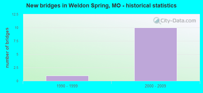
- New bridges - historical statistics
- 11990-1999
- 102000-2009


- Bridge Condition - Channel
- 20.0%Satisfactory
- 80.0%Fair
Find on map >> Show street view
Structure Number: 12028, Location: S 28 T 46 N R 3 E (Lat: 38.711761, Lng: -90.690336), Route carried "on" structure: State highway 94, Year Built: 2000, Status: Open, Structure Length: 9.81m (32.19ft), Average Daily Traffic: 17,690 (year 2021), Truck Traffic: 9%, Average Future Daily Traffic: 31,842 (year 2041), Design Load: HS 20+Mod, Features Intersected: IS 64
Minimum Vertical Clearance: 30+ m (98+ ft), Kilometerpoint: 159.723, Lanes on structure: 6, Lanes under structure: 7, Base Highway Network: Yes, Owner: State Highway Agency, Approaching Roadway Width: 27.4m (89.9ft), Skew: 3 degrees, Material/Design: Steel continuous, Design/Construction: Stringer/Multi-beam, Number Of Spans In Main Unit: 2, Length of Maximum Span: 42.5m (139.4ft), Curb-To-Curb Width: 27.6m (90.6ft), Out-to-Out Width: 28.6m (93.8ft)
Condition: Deck: Good, Superstructure: Good, Substructure: Good, Operating Rating: 80.1 metric tons, Method Used To Determine Operating Rating: Load Factor (LF), Inventory Rating: 48.6 metric tons, Method Used To Determine Inventory Rating: Load Factor (LF), Structural Evaluation: Better than present minimum criteria, Deck Geometry: Better than present minimum criteria, Underclear: Somewhat better than minimum adequacy, Approach Roadway Alignment: Equal to present desirable criteria, Designated Inspection Frequency: Every 24 months, Inspection Date: September 2021, Deck Structure Type: Concrete Cast-file-Place, Wearing Surface/Protective System: Wearing Surface: Monolithic Concrete, Deck Protection: Epoxy Coated Reinforcing
Find on map >> Show street view
Structure Number: 29119, Location: S 1669 T 46 N R 3 E (Lat: 38.714094, Lng: -90.703728), Route carried "on" structure: State highway K, Year Built: 2002, Status: Open, Structure Length: 6.49m (21.29ft), Average Daily Traffic: 30,137 (year 2021), Truck Traffic: 5%, Average Future Daily Traffic: 54,247 (year 2041), Design Load: HS 25 or greater, Features Intersected: IS 64
Minimum Vertical Clearance: 30+ m (98+ ft), Kilometerpoint: 10.361, Lanes on structure: 5, Lanes under structure: 7, Base Highway Network: Yes, Owner: State Highway Agency, Approaching Roadway Width: 25.6m (84.0ft), Material/Design: Steel continuous, Design/Construction: Stringer/Multi-beam, Number Of Spans In Main Unit: 2, Length of Maximum Span: 34.4m (112.9ft), Curb-To-Curb Width: 25.6m (84.0ft), Out-to-Out Width: 26.4m (86.6ft)
Condition: Deck: Good, Superstructure: Good, Substructure: Good, Operating Rating: 74.7 metric tons, Method Used To Determine Operating Rating: Load Factor (LF), Inventory Rating: 45.0 metric tons, Method Used To Determine Inventory Rating: Load Factor (LF), Structural Evaluation: Better than present minimum criteria, Deck Geometry: Superior to present desirable criteria, Underclear: High priority of corrective action, Approach Roadway Alignment: Equal to present desirable criteria, Designated Inspection Frequency: Every 24 months, Inspection Date: September 2021, Deck Structure Type: Concrete Cast-file-Place, Wearing Surface/Protective System: Wearing Surface: Monolithic Concrete, Deck Protection: Epoxy Coated Reinforcing
Find on map >> Show street view
Structure Number: 30127, Location: S 19 T 46 N R 4 E (Lat: 38.722875, Lng: -90.618103), Route carried "on" structure: County highway , Year Built: 2002, Status: Open, Structure Length: 0.93m (3.05ft), Average Daily Traffic: 4,669 (year 2020), Truck Traffic: 2%, Average Future Daily Traffic: 7,237 (year 2040), Features Intersected: BR OF DARDENNE CR, Facility Carried by Structure: KISKER RD
Minimum Vertical Clearance: 30+ m (98+ ft), Kilometerpoint: 0.000, Lanes on structure: 4, Owner: County Highway Agency, Approaching Roadway Width: 15.2m (49.9ft), Skew: 3 degrees, Material/Design: Concrete continuous, Design/Construction: Culvert, Number Of Spans In Main Unit: 2, Length of Maximum Span: 4.5m (14.8ft), Curb or Sidewalk Widths: Left: 1.2m (3.9ft), Right: 1.2m (3.9ft)
Condition: Channel: Fair, Culverts: Satisfactory, Operating Rating: 54.0 metric tons, Method Used To Determine Operating Rating: Field evaluation and documented engineering judgment, Inventory Rating: 32.4 metric tons, Method Used To Determine Inventory Rating: Field evaluation and documented engineering judgment, Structural Evaluation: Equal to present minimum criteria, Waterway Adequacy: Equal to present desirable criteria, Approach Roadway Alignment: Equal to present desirable criteria, Designated Inspection Frequency: Every 24 months, Inspection Date: Febuary 2022
Find on map >> Show street view
Structure Number: 30674, Location: S 19 T 46 N R 12 E (Lat: 38.720772, Lng: -90.616250), Route carried "on" structure: County highway , Year Built: 2004, Status: Open, Structure Length: 1.01m (3.31ft), Average Daily Traffic: 7,169 (year 2020), Truck Traffic: 3%, Average Future Daily Traffic: 11,112 (year 2040), Design Load: HS 20, Features Intersected: BALTIC CR, Facility Carried by Structure: TOWERS RD
Minimum Vertical Clearance: 30+ m (98+ ft), Kilometerpoint: 0.644, Lanes on structure: 2, Owner: County Highway Agency, Approaching Roadway Width: 11.6m (38.1ft), Material/Design: Concrete continuous, Design/Construction: Culvert, Number Of Spans In Main Unit: 2, Length of Maximum Span: 4.9m (16.1ft)
Condition: Channel: Fair, Culverts: Satisfactory, Operating Rating: 72.9 metric tons, Method Used To Determine Operating Rating: Load Factor (LF), Inventory Rating: 44.1 metric tons, Method Used To Determine Inventory Rating: Load Factor (LF), Structural Evaluation: Equal to present minimum criteria, Waterway Adequacy: Superior to present desirable criteria, Approach Roadway Alignment: Equal to present desirable criteria, Designated Inspection Frequency: Every 24 months, Inspection Date: Febuary 2022, Deck Structure Type: Concrete Cast-file-Place, Wearing Surface/Protective System: Wearing Surface: Monolithic Concrete
Find on map >> Show street view
Structure Number: 31762, Location: S 292 T 46 N R 4 E (Lat: 38.727225, Lng: -90.626497), Route carried "on" structure: County highway 245, Year Built: 2006, Status: Open, Structure Length: 1.41m (4.63ft), Average Daily Traffic: 4,968 (year 2020), Truck Traffic: 5%, Average Future Daily Traffic: 7,700 (year 2040), Design Load: HS 20, Features Intersected: TRIB OF DARDENNE C, Facility Carried by Structure: PITMAN HILL RD
Minimum Vertical Clearance: 30+ m (98+ ft), Kilometerpoint: 1.448, Lanes on structure: 2, Owner: County Highway Agency, Approaching Roadway Width: 11.0m (36.1ft), Skew: 3 degrees, Material/Design: Concrete, Design/Construction: Culvert, Number Of Spans In Main Unit: 1, Length of Maximum Span: 14.1m (46.3ft)
Condition: Channel: Fair, Culverts: Satisfactory, Operating Rating: 54.0 metric tons, Method Used To Determine Operating Rating: Load Factor (LF), Inventory Rating: 32.4 metric tons, Method Used To Determine Inventory Rating: Load Factor (LF), Structural Evaluation: Equal to present minimum criteria, Waterway Adequacy: Better than present minimum criteria, Approach Roadway Alignment: Better than present minimum criteria, Designated Inspection Frequency: Every 24 months, Inspection Date: Febuary 2022
Find on map >> Show street view
Structure Number: 35811, Location: S 1787 T 46 N R 3 E (Lat: 38.725556, Lng: -90.663861), Route carried "on" structure: County highway 481, Year Built: 1997, Status: Open, Structure Length: 0.94m (3.08ft), Average Daily Traffic: 250 (year 2020), Truck Traffic: 10%, Average Future Daily Traffic: 388 (year 2040), Design Load: HS 20, Features Intersected: TRIB CROOKED CR, Facility Carried by Structure: WRENWYCK PL
Minimum Vertical Clearance: 30+ m (98+ ft), Kilometerpoint: 0.805, Lanes on structure: 2, Owner: City or Municipal Highway Agency, Maintenance Responsibility: County Highway Agency, Approaching Roadway Width: 8.0m (26.2ft), Material/Design: Concrete, Design/Construction: Culvert, Number Of Spans In Main Unit: 2, Length of Maximum Span: 3.7m (12.1ft)
Condition: Channel: Satisfactory, Culverts: Satisfactory, Operating Rating: 43.2 metric tons, Method Used To Determine Operating Rating: Load Factor (LF), Inventory Rating: 25.2 metric tons, Method Used To Determine Inventory Rating: Load Factor (LF), Structural Evaluation: Equal to present minimum criteria, Waterway Adequacy: Superior to present desirable criteria, Approach Roadway Alignment: Equal to present desirable criteria, Designated Inspection Frequency: Every 24 months, Inspection Date: Febuary 2022
Find on map >> Show street view
Structure Number: 35812, Location: S 1785 T 46 N R 3 E (Lat: 38.721722, Lng: -90.642611), Route carried "on" structure: County highway 246, Year Built: 2009, Status: Open, Structure Length: 0.69m (2.26ft), Average Daily Traffic: 5,000 (year 2020), Truck Traffic: 10%, Average Future Daily Traffic: 7,750 (year 2040), Design Load: HS 20, Features Intersected: TRIB DARDENNE CR, Facility Carried by Structure: WOLFRUM RD
Minimum Vertical Clearance: 30+ m (98+ ft), Kilometerpoint: 1.127, Lanes on structure: 2, Owner: City or Municipal Highway Agency, Maintenance Responsibility: County Highway Agency, Approaching Roadway Width: 11.0m (36.1ft), Skew: 2 degrees, Material/Design: Concrete, Design/Construction: Culvert, Number Of Spans In Main Unit: 2, Length of Maximum Span: 3.3m (10.8ft), Curb or Sidewalk Widths: Left: 0.0m, Right: 2.6m (8.5ft), Out-to-Out Width: 18.6m (61.0ft)
Condition: Channel: Fair, Culverts: Satisfactory, Operating Rating: 31.5 metric tons, Method Used To Determine Operating Rating: Load Factor (LF), Inventory Rating: 18.9 metric tons, Method Used To Determine Inventory Rating: Load Factor (LF), Structural Evaluation: Somewhat better than minimum adequacy, Waterway Adequacy: Equal to present desirable criteria, Approach Roadway Alignment: Equal to present desirable criteria, Designated Inspection Frequency: Every 24 months, Inspection Date: Febuary 2022
Find on map >> Show street view
Structure Number: 12028, Location: S 28 T 46 N R 3 E (Lat: 38.711761, Lng: -90.690336), Route carried "under" structure: Interstate 64, Year Built: 2000, Structure Length: 0. m, Average Daily Traffic: 41,590 (year 2021), Truck Traffic: 7%, Features Intersected: IS 64, Facility Carried by Structure: MO 94 E
Minimum Vertical Clearance: 5.16m (16.93ft), Kilometerpoint: 48.414, Lanes on structure: 6, Lanes under structure: 3, Material/Design: Steel continuous, Design/Construction: Stringer/Multi-beam, Length of Maximum Span: 42.5m (139.4ft)
Find on map >> Show street view
Structure Number: 12028, Location: S 28 T 46 N R 3 E (Lat: 38.711761, Lng: -90.690336), Route carried "under" structure: Interstate 64, Year Built: 2000, Structure Length: 0. m, Average Daily Traffic: 32,670 (year 2021), Truck Traffic: 12%, Features Intersected: IS 64, Facility Carried by Structure: MO 94 E
Minimum Vertical Clearance: 5.61m (18.41ft), Kilometerpoint: 17.262, Lanes on structure: 6, Lanes under structure: 4, Material/Design: Steel continuous, Design/Construction: Stringer/Multi-beam, Length of Maximum Span: 42.5m (139.4ft)
Find on map >> Show street view
Structure Number: 29119, Location: S 1669 T 46 N R 3 E (Lat: 38.714094, Lng: -90.703728), Route carried "under" structure: Interstate 64, Year Built: 2002, Structure Length: 0. m, Average Daily Traffic: 29,845 (year 2021), Truck Traffic: 7%, Features Intersected: IS 64, Facility Carried by Structure: RT K S
Minimum Vertical Clearance: 5.21m (17.09ft), Kilometerpoint: 49.607, Lanes on structure: 5, Lanes under structure: 3, Material/Design: Steel continuous, Design/Construction: Stringer/Multi-beam, Length of Maximum Span: 34.4m (112.9ft)
Find on map >> Show street view
Structure Number: 29119, Location: S 1669 T 46 N R 3 E (Lat: 38.714094, Lng: -90.703728), Route carried "under" structure: Interstate 64, Year Built: 2002, Structure Length: 0. m, Average Daily Traffic: 27,569 (year 2021), Truck Traffic: 12%, Features Intersected: IS 64, Facility Carried by Structure: RT K S
Minimum Vertical Clearance: 5.21m (17.09ft), Kilometerpoint: 16.081, Lanes on structure: 5, Lanes under structure: 4, Material/Design: Steel continuous, Design/Construction: Stringer/Multi-beam, Length of Maximum Span: 34.4m (112.9ft)