Bridge Statistics for Wellston, Ohio (OH)
Condition, Traffic, Stress, Structural Evaluation, Project Costs
- National Bridge Inventory (NBI) Statistics
- 25Number of bridges
- 190ft / 58.0mTotal length
- 85,620Total average daily traffic
- 8,125Total average daily truck traffic
- National Bridge Inventory (NBI) Registered Bridges for Wellston
- No street view available for this location
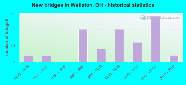
- New bridges - historical statistics
- 11930-1939
- 11940-1949
- 51960-1969
- 21970-1979
- 51980-1989
- 31990-1999
- 72000-2009
- 12010-2019

- Reconstructed bridges - Historical Statistics
- 11990-1999
- 22000-2009


- Bridge Condition - Deck
- 9.5%Excellent
- 42.9%Very good
- 19.0%Good
- 14.3%Satisfactory
- 9.5%Fair
- 4.8%Poor

- Bridge Condition - Superstructure
- 28.6%Very good
- 47.6%Good
- 9.5%Satisfactory
- 9.5%Fair
- 4.8%Poor

- Bridge Condition - Substructure
- 4.8%Excellent
- 28.6%Very good
- 38.1%Good
- 14.3%Satisfactory
- 9.5%Fair
- 4.8%Poor

- Bridge Condition - Channel
- 52.6%Very good
- 26.3%Good
- 15.8%Satisfactory
- 5.3%Poor
Find on map >> Show street view
Structure Number: 4001605, Location: JCT SR 349 (Lat: 39.132831, Lng: -82.530019), Route carried "on" structure: State highway 93, Year Built: 1992, Status: Open, Structure Length: 1.56m (5.12ft), Average Daily Traffic: 6,257 (year 2015), Truck Traffic: 5%, Average Future Daily Traffic: 8,685 (year 2035), Design Load: HS 20+Mod, Features Intersected: SAND RUN
Minimum Vertical Clearance: 30+ m (98+ ft), Kilometerpoint: 43.999, Lanes on structure: 2, Base Highway Network: Yes, Owner: State Highway Agency, Approaching Roadway Width: 9.1m (29.9ft), Skew: 3 degrees, Material/Design: Prestressed concrete, Design/Construction: Box Beam or Girders - Multiple, Number Of Spans In Main Unit: 1, Length of Maximum Span: 15.2m (49.9ft), Curb-To-Curb Width: 13.4m (44.0ft), Out-to-Out Width: 13.4m (44.0ft)
Condition: Deck: Very good, Superstructure: Good, Substructure: Very good, Channel: Very good, Operating Rating: 42.1 metric tons, Method Used To Determine Operating Rating: Allowable Stress (AS) rating reported by rating factor (RF) method using MS18 loading, Inventory Rating: 32.4 metric tons, Method Used To Determine Inventory Rating: Allowable Stress (AS) rating reported by rating factor (RF) method using MS18 loading, Structural Evaluation: Better than present minimum criteria, Deck Geometry: Equal to present minimum criteria, Waterway Adequacy: Equal to present desirable criteria, Approach Roadway Alignment: Equal to present desirable criteria, Designated Inspection Frequency: Every 24 months, Inspection Date: November 2020, Deck Structure Type: Concrete Cast-file-Place, Wearing Surface/Protective System: Wearing Surface: Bituminous, Membrane: Preformed Fabric
Find on map >> Show street view
Structure Number: 4001613, Location: .7 MI S OF VINTON LINE (Lat: 39.142589, Lng: -82.532700), Route carried "on" structure: State highway 93, Year Built: 1981, Status: Open, Structure Length: 1.55m (5.09ft), Average Daily Traffic: 6,257 (year 2015), Truck Traffic: 5%, Average Future Daily Traffic: 8,685 (year 2035), Design Load: HS 20, Features Intersected: SAND RUN
Minimum Vertical Clearance: 30+ m (98+ ft), Kilometerpoint: 45.223, Lanes on structure: 2, Base Highway Network: Yes, Owner: State Highway Agency, Approaching Roadway Width: 13.7m (44.9ft), Material/Design: Prestressed concrete, Design/Construction: Box Beam or Girders - Multiple, Number Of Spans In Main Unit: 1, Length of Maximum Span: 14.9m (48.9ft), Curb-To-Curb Width: 13.5m (44.3ft), Out-to-Out Width: 13.5m (44.3ft)
Condition: Deck: Very good, Superstructure: Very good, Substructure: Very good, Channel: Good, Operating Rating: 42.1 metric tons, Method Used To Determine Operating Rating: Allowable Stress (AS) rating reported by rating factor (RF) method using MS18 loading, Inventory Rating: 32.4 metric tons, Method Used To Determine Inventory Rating: Allowable Stress (AS) rating reported by rating factor (RF) method using MS18 loading, Structural Evaluation: Equal to present desirable criteria, Deck Geometry: Superior to present desirable criteria, Waterway Adequacy: Equal to present desirable criteria, Approach Roadway Alignment: Equal to present desirable criteria, Designated Inspection Frequency: Every 24 months, Inspection Date: November 2020, Deck Structure Type: Concrete Cast-file-Place, Wearing Surface/Protective System: Wearing Surface: Bituminous
Find on map >> Show street view
Structure Number: 4002229, Location: 0.02MI W OF JCT SR 124 (Lat: 39.080039, Lng: -82.541181), Route carried "on" structure: State highway 32, Year Built: 1969, Status: Open, Structure Length: 0.70m (2.30ft), Average Daily Traffic: 9,601 (year 2015), Truck Traffic: 13%, Average Future Daily Traffic: 13,326 (year 2035), Design Load: HS 20, Features Intersected: MEADOW RUN
Minimum Vertical Clearance: 30+ m (98+ ft), Kilometerpoint: 26.667, Lanes on structure: 4, Base Highway Network: Yes, Owner: State Highway Agency, Approaching Roadway Width: 31.7m (104.0ft), Skew: 4 degrees, Material/Design: Concrete, Design/Construction: Culvert, Number Of Spans In Main Unit: 2, Length of Maximum Span: 3.4m (11.2ft)
Condition: Channel: Satisfactory, Culverts: Satisfactory, Operating Rating: 48.6 metric tons, Method Used To Determine Operating Rating: Load and Resistance Factor Rating (LRFR) rating reported by rating factor(RF) method using HL-93 loadings, Inventory Rating: 38.9 metric tons, Method Used To Determine Inventory Rating: Load and Resistance Factor Rating (LRFR) rating reported by rating factor(RF) method using HL-93 loadings, Structural Evaluation: Equal to present minimum criteria, Waterway Adequacy: Superior to present desirable criteria, Approach Roadway Alignment: Better than present minimum criteria, Designated Inspection Frequency: Every 12 months, Inspection Date: July 2021
Find on map >> Show street view
Structure Number: 4002237, Location: .01 MI W OF JCT 124 (Lat: 39.080339, Lng: -82.540661), Route carried "on" structure: County highway C0078, Year Built: 2004, Status: Open, Structure Length: 6.18m (20.28ft), Average Daily Traffic: 80 (year 2015), Truck Traffic: 5%, Average Future Daily Traffic: 13,326 (year 2035), Design Load: HS 20+Mod, Features Intersected: STATE ROUTE 32, Facility Carried by Structure: COUNTY ROAD 78
Minimum Vertical Clearance: 30+ m (98+ ft), Kilometerpoint: 55.200, Lanes on structure: 2, Lanes under structure: 4, Owner: State Highway Agency, Approaching Roadway Width: 11.0m (36.1ft), Material/Design: Steel continuous, Design/Construction: Stringer/Multi-beam, Number Of Spans In Main Unit: 2, Length of Maximum Span: 30.6m (100.4ft), Curb-To-Curb Width: 10.8m (35.4ft), Out-to-Out Width: 11.7m (38.4ft)
Condition: Deck: Very good, Superstructure: Very good, Substructure: Good, Operating Rating: 42.1 metric tons, Method Used To Determine Operating Rating: Load Factor (LF) rating reported by rating factor (RF) method using MS18 loading, Inventory Rating: 32.4 metric tons, Method Used To Determine Inventory Rating: Load Factor (LF) rating reported by rating factor (RF) method using MS18 loading, Structural Evaluation: Better than present minimum criteria, Deck Geometry: Superior to present desirable criteria, Underclear: Superior to present desirable criteria, Approach Roadway Alignment: Superior to present desirable criteria, Designated Inspection Frequency: Every 24 months, Inspection Date: October 2020, Deck Structure Type: Concrete Cast-file-Place, Wearing Surface/Protective System: Wearing Surface: Monolithic Concrete, Membrane: Built-up, Deck Protection: Epoxy Coated Reinforcing
Find on map >> Show street view
Structure Number: 4002245, Location: .57 MI E OF JCT 124 (Lat: 39.087650, Lng: -82.537869), Route carried "on" structure: State highway 32, Year Built: 2004, Status: Open, Structure Length: 4.08m (13.39ft), Average Daily Traffic: 3,470 (year 2015), Truck Traffic: 16%, Average Future Daily Traffic: 4,816 (year 2035), Design Load: HS 25 or greater, Features Intersected: STATE ROUTE 327
Minimum Vertical Clearance: 30+ m (98+ ft), Kilometerpoint: 27.552, Lanes on structure: 2, Lanes under structure: 3, Base Highway Network: Yes, Owner: State Highway Agency, Approaching Roadway Width: 13.2m (43.3ft), Skew: 4 degrees, Material/Design: Prestressed concrete, Design/Construction: Stringer/Multi-beam, Number Of Spans In Main Unit: 1, Length of Maximum Span: 39.5m (129.6ft), Curb-To-Curb Width: 13.2m (43.3ft), Out-to-Out Width: 14.1m (46.3ft)
Condition: Deck: Very good, Superstructure: Good, Substructure: Good, Operating Rating: 42.1 metric tons, Method Used To Determine Operating Rating: Load Factor (LF) rating reported by rating factor (RF) method using MS18 loading, Inventory Rating: 32.4 metric tons, Method Used To Determine Inventory Rating: Load Factor (LF) rating reported by rating factor (RF) method using MS18 loading, Structural Evaluation: Better than present minimum criteria, Deck Geometry: Superior to present desirable criteria, Underclear: Superior to present desirable criteria, Approach Roadway Alignment: Better than present minimum criteria, Designated Inspection Frequency: Every 24 months, Inspection Date: August 2020, Deck Structure Type: Concrete Cast-file-Place, Wearing Surface/Protective System: Wearing Surface: Monolithic Concrete, Membrane: Built-up, Deck Protection: Epoxy Coated Reinforcing
Find on map >> Show street view
Structure Number: 4002253, Location: .57 MI E OF JCT 124 (Lat: 39.087419, Lng: -82.537881), Route carried "on" structure: State highway 32, Year Built: 2004, Status: Open, Structure Length: 4.08m (13.39ft), Average Daily Traffic: 3,470 (year 2015), Truck Traffic: 16%, Average Future Daily Traffic: 4,816 (year 2035), Design Load: HS 25 or greater, Features Intersected: STATE ROUTE 327
Minimum Vertical Clearance: 30+ m (98+ ft), Kilometerpoint: 27.552, Lanes on structure: 2, Lanes under structure: 3, Base Highway Network: Yes, Owner: State Highway Agency, Approaching Roadway Width: 13.4m (44.0ft), Skew: 4 degrees, Material/Design: Prestressed concrete, Design/Construction: Stringer/Multi-beam, Number Of Spans In Main Unit: 1, Length of Maximum Span: 39.5m (129.6ft), Curb-To-Curb Width: 13.2m (43.3ft), Out-to-Out Width: 14.1m (46.3ft)
Condition: Deck: Very good, Superstructure: Good, Substructure: Good, Operating Rating: 42.1 metric tons, Method Used To Determine Operating Rating: Load Factor (LF) rating reported by rating factor (RF) method using MS18 loading, Inventory Rating: 32.4 metric tons, Method Used To Determine Inventory Rating: Load Factor (LF) rating reported by rating factor (RF) method using MS18 loading, Structural Evaluation: Better than present minimum criteria, Deck Geometry: Superior to present desirable criteria, Underclear: Superior to present desirable criteria, Approach Roadway Alignment: Better than present minimum criteria, Designated Inspection Frequency: Every 24 months, Inspection Date: August 2020, Deck Structure Type: Concrete Cast-file-Place, Wearing Surface/Protective System: Wearing Surface: Monolithic Concrete, Membrane: Built-up, Deck Protection: Epoxy Coated Reinforcing
Find on map >> Show street view
Structure Number: 4002288, Location: 2.63 MI E OF JCT 327 (Lat: 39.085331, Lng: -82.485911), Route carried "on" structure: State highway 124, Year Built: 1935, Year Reconstructed: 2012, Status: Open, Structure Length: 1.51m (4.95ft), Average Daily Traffic: 990 (year 2015), Truck Traffic: 11%, Average Future Daily Traffic: 1,374 (year 2035), Design Load: HS 25 or greater, Features Intersected: BUNDINS RUN
Minimum Vertical Clearance: 30+ m (98+ ft), Kilometerpoint: 32.460, Lanes on structure: 2, Owner: State Highway Agency, Approaching Roadway Width: 7.9m (25.9ft), Skew: 3 degrees, Material/Design: Concrete, Design/Construction: Tee Beam, Number Of Spans In Main Unit: 1, Length of Maximum Span: 14.0m (45.9ft), Curb-To-Curb Width: 9.8m (32.2ft), Out-to-Out Width: 9.8m (32.2ft)
Condition: Deck: Excellent, Superstructure: Very good, Substructure: Very good, Channel: Good, Operating Rating: 61.6 metric tons, Method Used To Determine Operating Rating: Load and Resistance Factor Rating (LRFR) rating reported by rating factor(RF) method using HL-93 loadings, Inventory Rating: 42.1 metric tons, Method Used To Determine Inventory Rating: Load and Resistance Factor Rating (LRFR) rating reported by rating factor(RF) method using HL-93 loadings, Structural Evaluation: Equal to present desirable criteria, Deck Geometry: Equal to present minimum criteria, Waterway Adequacy: Equal to present minimum criteria, Approach Roadway Alignment: Equal to present desirable criteria, Designated Inspection Frequency: Every 24 months, Inspection Date: November 2020, Deck Structure Type: Concrete Cast-file-Place, Wearing Surface/Protective System: Wearing Surface: Integral Concrete
Find on map >> Show street view
Structure Number: 4002326, Location: 3.9 MI E OF JCT 327 (Lat: 39.086231, Lng: -82.471589), Route carried "on" structure: State highway 124, Year Built: 1997, Status: Open, Structure Length: 4.08m (13.39ft), Average Daily Traffic: 990 (year 2015), Truck Traffic: 11%, Average Future Daily Traffic: 1,374 (year 2035), Design Load: HS 20+Mod, Features Intersected: LITTLE RACCOON CREEK
Minimum Vertical Clearance: 30+ m (98+ ft), Kilometerpoint: 34.488, Lanes on structure: 2, Owner: State Highway Agency, Approaching Roadway Width: 11.0m (36.1ft), Skew: 2 degrees, Material/Design: Prestressed concrete continuous, Design/Construction: Box Beam or Girders - Multiple, Number Of Spans In Main Unit: 3, Length of Maximum Span: 15.5m (50.9ft), Curb or Sidewalk Widths: Left: 0.0m, Right: 10.0m (32.8ft), Curb-To-Curb Width: 11.0m (36.1ft), Out-to-Out Width: 11.0m (36.1ft)
Condition: Deck: Good, Superstructure: Good, Substructure: Very good, Channel: Very good, Operating Rating: 42.1 metric tons, Method Used To Determine Operating Rating: Load Factor (LF) rating reported by rating factor (RF) method using MS18 loading, Inventory Rating: 32.4 metric tons, Method Used To Determine Inventory Rating: Load Factor (LF) rating reported by rating factor (RF) method using MS18 loading, Structural Evaluation: Better than present minimum criteria, Deck Geometry: Better than present minimum criteria, Waterway Adequacy: Equal to present desirable criteria, Approach Roadway Alignment: Equal to present desirable criteria, Designated Inspection Frequency: Every 24 months, Inspection Date: November 2020, Deck Structure Type: Concrete Cast-file-Place, Wearing Surface/Protective System: Wearing Surface: Monolithic Concrete, Membrane: Built-up, Deck Protection: Epoxy Coated Reinforcing
Find on map >> Show street view
Structure Number: 4003357, Location: 4.25 MI N OF US 35 (Lat: 39.038189, Lng: -82.538811), Route carried "on" structure: State highway 327, Year Built: 1989, Status: Open, Structure Length: 1.80m (5.91ft), Average Daily Traffic: 1,569 (year 2015), Truck Traffic: 10%, Average Future Daily Traffic: 2,178 (year 2035), Design Load: HS 20+Mod, Features Intersected: DICKASON RUN
Minimum Vertical Clearance: 30+ m (98+ ft), Kilometerpoint: 6.148, Lanes on structure: 2, Owner: State Highway Agency, Approaching Roadway Width: 9.8m (32.2ft), Skew: 1 degrees, Material/Design: Prestressed concrete, Design/Construction: Box Beam or Girders - Multiple, Number Of Spans In Main Unit: 1, Length of Maximum Span: 15.2m (49.9ft), Curb-To-Curb Width: 9.8m (32.2ft), Out-to-Out Width: 9.8m (32.2ft)
Condition: Deck: Fair, Superstructure: Fair, Substructure: Very good, Channel: Satisfactory, Operating Rating: 51.8 metric tons, Method Used To Determine Operating Rating: Load and Resistance Factor Rating (LRFR) rating reported by rating factor(RF) method using HL-93 loadings, Inventory Rating: 29.2 metric tons, Method Used To Determine Inventory Rating: Load and Resistance Factor Rating (LRFR) rating reported by rating factor(RF) method using HL-93 loadings, Structural Evaluation: Somewhat better than minimum adequacy, Deck Geometry: Somewhat better than minimum adequacy, Waterway Adequacy: Better than present minimum criteria, Approach Roadway Alignment: Equal to present desirable criteria, Designated Inspection Frequency: Every 12 months, Inspection Date: August 2021, Deck Structure Type: Concrete Cast-file-Place, Wearing Surface/Protective System: Wearing Surface: Bituminous, Membrane: Built-up, Deck Protection: Epoxy Coated Reinforcing
Find on map >> Show street view
Structure Number: 4003543, Location: WELLSTON (Lat: 39.104911, Lng: -82.535881), Route carried "on" structure: State highway 327, Year Built: 1962, Status: Open, Structure Length: 2.62m (8.60ft), Average Daily Traffic: 10,554 (year 2015), Truck Traffic: 6%, Average Future Daily Traffic: 14,649 (year 2035), Design Load: H 15, Features Intersected: MEADOW RUN
Minimum Vertical Clearance: 30+ m (98+ ft), Kilometerpoint: 13.647, Lanes on structure: 2, Base Highway Network: Yes, Owner: State Highway Agency, Approaching Roadway Width: 13.7m (44.9ft), Skew: 3 degrees, Material/Design: Concrete continuous, Design/Construction: Slab, Number Of Spans In Main Unit: 3, Length of Maximum Span: 26.2m (86.0ft), Curb-To-Curb Width: 13.1m (43.0ft), Out-to-Out Width: 13.7m (44.9ft)
Condition: Deck: Satisfactory, Superstructure: Satisfactory, Substructure: Fair, Channel: Very good, Operating Rating: 29.2 metric tons, Method Used To Determine Operating Rating: Load and Resistance Factor Rating (LRFR) rating reported by rating factor(RF) method using HL-93 loadings, Inventory Rating: 22.7 metric tons, Method Used To Determine Inventory Rating: Load and Resistance Factor Rating (LRFR) rating reported by rating factor(RF) method using HL-93 loadings, Structural Evaluation: Somewhat better than minimum adequacy, Deck Geometry: Somewhat better than minimum adequacy, Waterway Adequacy: Equal to present minimum criteria, Approach Roadway Alignment: Better than present minimum criteria, Designated Inspection Frequency: Every 12 months, Inspection Date: August 2021, Deck Structure Type: Concrete Cast-file-Place, Wearing Surface/Protective System: Wearing Surface: Bituminous
Find on map >> Show street view
Structure Number: 4003756, Location: 3.05MI E OF JCT SR 327 (Lat: 39.100239, Lng: -82.484989), Route carried "on" structure: State highway 32, Year Built: 1969, Status: Open, Structure Length: 3.63m (11.91ft), Average Daily Traffic: 2,138 (year 2015), Truck Traffic: 23%, Average Future Daily Traffic: 2,968 (year 2035), Design Load: HS 20, Features Intersected: LITTLE RACCOON CREEK
Minimum Vertical Clearance: 30+ m (98+ ft), Kilometerpoint: 32.525, Lanes on structure: 2, Base Highway Network: Yes, Owner: State Highway Agency, Approaching Roadway Width: 12.2m (40.0ft), Material/Design: Concrete continuous, Design/Construction: Slab, Number Of Spans In Main Unit: 3, Length of Maximum Span: 13.7m (44.9ft), Curb-To-Curb Width: 12.2m (40.0ft), Out-to-Out Width: 12.2m (40.0ft)
Condition: Deck: Good, Superstructure: Good, Substructure: Satisfactory, Channel: Very good, Operating Rating: 42.1 metric tons, Method Used To Determine Operating Rating: Allowable Stress (AS) rating reported by rating factor (RF) method using MS18 loading, Inventory Rating: 32.4 metric tons, Method Used To Determine Inventory Rating: Allowable Stress (AS) rating reported by rating factor (RF) method using MS18 loading, Structural Evaluation: Equal to present minimum criteria, Deck Geometry: Better than present minimum criteria, Waterway Adequacy: Superior to present desirable criteria, Approach Roadway Alignment: Superior to present desirable criteria, Designated Inspection Frequency: Every 12 months, Underwater Inspection Frequency: Every 60 months, Inspection Date: July 2021, Underwater Inspection Date: June 2019, Deck Structure Type: Concrete Cast-file-Place, Wearing Surface/Protective System: Wearing Surface: Integral Concrete
Find on map >> Show street view
Structure Number: 400378, Location: 3.05MI E OF JCT SR 327 (Lat: 39.100119, Lng: -82.484819), Route carried "on" structure: State highway 32, Year Built: 1969, Status: Open, Structure Length: 3.63m (11.91ft), Average Daily Traffic: 2,138 (year 2015), Truck Traffic: 23%, Average Future Daily Traffic: 2,968 (year 2035), Design Load: HS 20, Features Intersected: LITTLE RACCOON CREEK
Minimum Vertical Clearance: 30+ m (98+ ft), Kilometerpoint: 32.525, Lanes on structure: 2, Base Highway Network: Yes, Owner: State Highway Agency, Approaching Roadway Width: 12.2m (40.0ft), Material/Design: Concrete continuous, Design/Construction: Slab, Number Of Spans In Main Unit: 3, Length of Maximum Span: 13.7m (44.9ft), Curb-To-Curb Width: 12.2m (40.0ft), Out-to-Out Width: 12.2m (40.0ft)
Condition: Deck: Satisfactory, Superstructure: Good, Substructure: Satisfactory, Channel: Very good, Operating Rating: 42.1 metric tons, Method Used To Determine Operating Rating: Allowable Stress (AS) rating reported by rating factor (RF) method using MS18 loading, Inventory Rating: 32.4 metric tons, Method Used To Determine Inventory Rating: Allowable Stress (AS) rating reported by rating factor (RF) method using MS18 loading, Structural Evaluation: Equal to present minimum criteria, Deck Geometry: Better than present minimum criteria, Waterway Adequacy: Superior to present desirable criteria, Approach Roadway Alignment: Superior to present desirable criteria, Designated Inspection Frequency: Every 12 months, Underwater Inspection Frequency: Every 60 months, Inspection Date: July 2021, Underwater Inspection Date: June 2019, Deck Structure Type: Concrete Cast-file-Place, Wearing Surface/Protective System: Wearing Surface: Integral Concrete
Find on map >> Show street view
Structure Number: 4003837, Location: 0.5MI N OF JCT SR 93 (Lat: 39.135650, Lng: -82.521831), Route carried "on" structure: State highway 349, Year Built: 1984, Status: Open, Structure Length: 2.47m (8.10ft), Average Daily Traffic: 1,373 (year 2015), Truck Traffic: 5%, Average Future Daily Traffic: 1,906 (year 2035), Design Load: HS 20, Features Intersected: SAND RUN
Minimum Vertical Clearance: 30+ m (98+ ft), Kilometerpoint: 0.789, Lanes on structure: 2, Owner: State Highway Agency, Approaching Roadway Width: 9.8m (32.2ft), Skew: 3 degrees, Material/Design: Concrete continuous, Design/Construction: Slab, Number Of Spans In Main Unit: 3, Length of Maximum Span: 9.1m (29.9ft), Curb-To-Curb Width: 9.8m (32.2ft), Out-to-Out Width: 9.8m (32.2ft)
Condition: Deck: Very good, Superstructure: Very good, Substructure: Good, Channel: Good, Operating Rating: 42.1 metric tons, Method Used To Determine Operating Rating: Allowable Stress (AS) rating reported by rating factor (RF) method using MS18 loading, Inventory Rating: 32.4 metric tons, Method Used To Determine Inventory Rating: Allowable Stress (AS) rating reported by rating factor (RF) method using MS18 loading, Structural Evaluation: Better than present minimum criteria, Deck Geometry: Somewhat better than minimum adequacy, Waterway Adequacy: Equal to present desirable criteria, Approach Roadway Alignment: Meets minimum limits, Designated Inspection Frequency: Every 24 months, Inspection Date: November 2020, Deck Structure Type: Concrete Cast-file-Place, Wearing Surface/Protective System: Wearing Surface: Epoxy Overlay
Find on map >> Show street view
Structure Number: 4003861, Location: LAKE ALMA (Lat: 39.141000, Lng: -82.516131), Route carried "on" structure: State highway 349, Year Built: 1977, Status: Open, Structure Length: 5.73m (18.80ft), Average Daily Traffic: 1,373 (year 2015), Truck Traffic: 5%, Average Future Daily Traffic: 1,906 (year 2035), Design Load: H 15, Features Intersected: LITTLE RACCOON
Minimum Vertical Clearance: 30+ m (98+ ft), Kilometerpoint: 1.577, Lanes on structure: 2, Owner: State Highway Agency, Approaching Roadway Width: 11.0m (36.1ft), Skew: 4 degrees, Material/Design: Steel continuous, Design/Construction: Stringer/Multi-beam, Number Of Spans In Main Unit: 3, Length of Maximum Span: 20.7m (67.9ft), Curb-To-Curb Width: 11.0m (36.1ft), Out-to-Out Width: 11.0m (36.1ft)
Condition: Deck: Very good, Superstructure: Good, Substructure: Very good, Channel: Very good, Operating Rating: 42.1 metric tons, Method Used To Determine Operating Rating: Allowable Stress (AS) rating reported by rating factor (RF) method using MS18 loading, Inventory Rating: 32.4 metric tons, Method Used To Determine Inventory Rating: Allowable Stress (AS) rating reported by rating factor (RF) method using MS18 loading, Structural Evaluation: Better than present minimum criteria, Deck Geometry: Equal to present minimum criteria, Waterway Adequacy: Equal to present desirable criteria, Approach Roadway Alignment: Equal to present desirable criteria, Designated Inspection Frequency: Every 24 months, Inspection Date: November 2020, Deck Structure Type: Concrete Cast-file-Place, Wearing Surface/Protective System: Wearing Surface: Bituminous
Find on map >> Show street view
Structure Number: 4030214, Location: 100 FT W OF CR40 (Lat: 39.117181, Lng: -82.469281), Route carried "on" structure: County highway C0039, Year Built: 1963, Year Reconstructed: 2002, Status: Open, Structure Length: 1.65m (5.41ft), Average Daily Traffic: 911 (year 2015), Truck Traffic: 2%, Average Future Daily Traffic: 1,264 (year 2035), Design Load: H 20, Features Intersected: MULGA CREEK, Facility Carried by Structure: MULGA RD
Minimum Vertical Clearance: 30+ m (98+ ft), Kilometerpoint: 4.925, Lanes on structure: 2, Owner: County Highway Agency, Approaching Roadway Width: 7.0m (23.0ft), Material/Design: Steel, Design/Construction: Truss - Thru, Number Of Spans In Main Unit: 1, Length of Maximum Span: 16.2m (53.1ft), Curb-To-Curb Width: 6.0m (19.7ft), Out-to-Out Width: 6.1m (20.0ft)
Condition: Deck: Good, Superstructure: Fair, Substructure: Good, Channel: Poor, Operating Rating: 48.6 metric tons, Method Used To Determine Operating Rating: Load Factor (LF) rating reported by rating factor (RF) method using MS18 loading, Inventory Rating: 29.2 metric tons, Method Used To Determine Inventory Rating: Load Factor (LF) rating reported by rating factor (RF) method using MS18 loading, Structural Evaluation: Somewhat better than minimum adequacy, Deck Geometry: High priority of replacement, Waterway Adequacy: Equal to present minimum criteria, Approach Roadway Alignment: Equal to present desirable criteria, Designated Inspection Frequency: Every 12 months, Critical Feature Inspection Frequency: Every 24 months, Inspection Date: May 2021, Critical Feature Inspection Date: May 2020, Deck Structure Type: Corrugated Steel, Wearing Surface/Protective System: Wearing Surface: Bituminous
Find on map >> Show street view
Structure Number: 403118, Location: 200 FT S OF ST RT 327 (Lat: 39.135319, Lng: -82.574831), Route carried "on" structure: County highway C0035, Year Built: 1944, Year Reconstructed: 2013, Status: Open, Structure Length: 0.91m (2.99ft), Average Daily Traffic: 282 (year 2015), Average Future Daily Traffic: 391 (year 2035), Design Load: HL 93, Features Intersected: TRIB TO SAND RUN, Facility Carried by Structure: GLENROY RD
Minimum Vertical Clearance: 30+ m (98+ ft), Kilometerpoint: 2.704, Lanes on structure: 2, Owner: County Highway Agency, Approaching Roadway Width: 6.4m (21.0ft), Skew: 2 degrees, Material/Design: Concrete, Design/Construction: Tee Beam, Number Of Spans In Main Unit: 1, Length of Maximum Span: 8.8m (28.9ft), Curb-To-Curb Width: 6.1m (20.0ft), Out-to-Out Width: 6.1m (20.0ft)
Condition: Deck: Very good, Superstructure: Very good, Substructure: Good, Channel: Very good, Operating Rating: 74.5 metric tons, Method Used To Determine Operating Rating: Load and Resistance Factor Rating (LRFR) rating reported by rating factor(RF) method using HL-93 loadings, Inventory Rating: 45.4 metric tons, Method Used To Determine Inventory Rating: Load and Resistance Factor Rating (LRFR) rating reported by rating factor(RF) method using HL-93 loadings, Structural Evaluation: Better than present minimum criteria, Deck Geometry: Meets minimum limits, Waterway Adequacy: Equal to present desirable criteria, Approach Roadway Alignment: Equal to present desirable criteria, Designated Inspection Frequency: Every 24 months, Inspection Date: May 2021, Deck Structure Type: Concrete Cast-file-Place, Wearing Surface/Protective System: Wearing Surface: Bituminous, Deck Protection: Epoxy Coated Reinforcing
Find on map >> Show street view
Structure Number: 4033265, Location: 1.33 Miles NW of C-39 (Lat: 39.133981, Lng: -82.507689), Route carried "on" structure: County highway T-384, Year Built: 2019, Status: Open, Structure Length: 2.93m (9.61ft), Average Daily Traffic: 535 (year 2020), Truck Traffic: 7%, Average Future Daily Traffic: 589 (year 2040), Design Load: HS 20, Features Intersected: Little Raccoon Creek, Facility Carried by Structure: Wellston Park Road
Minimum Vertical Clearance: 30+ m (98+ ft), Kilometerpoint: 2.140, Lanes on structure: 2, Owner: County Highway Agency, Approaching Roadway Width: 4.9m (16.1ft), Material/Design: Steel, Design/Construction: Truss - Thru, Number Of Spans In Main Unit: 1, Length of Maximum Span: 28.7m (94.2ft), Curb-To-Curb Width: 5.5m (18.0ft), Out-to-Out Width: 5.5m (18.0ft)
Condition: Deck: Excellent, Superstructure: Good, Substructure: Excellent, Channel: Very good, Operating Rating: 63.5 metric tons, Method Used To Determine Operating Rating: Load Factor (LF) rating reported by rating factor (RF) method using MS18 loading, Inventory Rating: 41.1 metric tons, Method Used To Determine Inventory Rating: Load Factor (LF) rating reported by rating factor (RF) method using MS18 loading, Structural Evaluation: Better than present minimum criteria, Deck Geometry: High priority of replacement, Waterway Adequacy: Equal to present desirable criteria, Approach Roadway Alignment: Equal to present desirable criteria, Designated Inspection Frequency: Every 12 months, Critical Feature Inspection Frequency: Every 24 months, Inspection Date: May 2021, Critical Feature Inspection Date: May 2021, Deck Structure Type: Concrete Cast-file-Place, Wearing Surface/Protective System: Wearing Surface: Monolithic Concrete
Find on map >> Show street view
Structure Number: 4033272, Location: 0.19 MI E OF CR39 (Lat: 39.115581, Lng: -82.515511), Route carried "on" structure: County highway T0383, Year Built: 1990, Status: Open, Structure Length: 1.22m (4.00ft), Average Daily Traffic: 24 (year 2015), Average Future Daily Traffic: 33 (year 2035), Design Load: HS 20, Features Intersected: MEADOW RUN, Facility Carried by Structure: CHEATWOOD RD
Minimum Vertical Clearance: 30+ m (98+ ft), Kilometerpoint: 0.306, Lanes on structure: 1, Owner: County Highway Agency, Approaching Roadway Width: 4.3m (14.1ft), Material/Design: Steel, Design/Construction: Stringer/Multi-beam, Number Of Spans In Main Unit: 1, Length of Maximum Span: 11.6m (38.1ft), Curb-To-Curb Width: 4.9m (16.1ft), Out-to-Out Width: 5.0m (16.4ft)
Condition: Deck: Satisfactory, Superstructure: Good, Substructure: Fair, Channel: Satisfactory, Operating Rating: 38.9 metric tons, Method Used To Determine Operating Rating: Allowable Stress (AS) rating reported by rating factor (RF) method using MS18 loading, Inventory Rating: 25.9 metric tons, Method Used To Determine Inventory Rating: Allowable Stress (AS) rating reported by rating factor (RF) method using MS18 loading, Structural Evaluation: Somewhat better than minimum adequacy, Deck Geometry: High priority of corrective action, Waterway Adequacy: Equal to present desirable criteria, Approach Roadway Alignment: Equal to present desirable criteria, Designated Inspection Frequency: Every 12 months, Inspection Date: May 2021, Deck Structure Type: Wood or Timber, Wearing Surface/Protective System: Wearing Surface: Bituminous
Find on map >> Show street view
Structure Number: 4034155, Location: 0.4 MI W OF SR327 (Lat: 39.053319, Lng: -82.546939), Route carried "on" structure: County highway C0010, Year Built: 1986, Status: Posted for load, Structure Length: 0.73m (2.40ft), Average Daily Traffic: 1,183 (year 2015), Truck Traffic: 1%, Average Future Daily Traffic: 1,642 (year 2035), Design Load: H 20, Features Intersected: DICKASON RUN, Facility Carried by Structure: PATTONSVILLE RD
Minimum Vertical Clearance: 30+ m (98+ ft), Kilometerpoint: 6.920, Lanes on structure: 2, Owner: County Highway Agency, Approaching Roadway Width: 6.7m (22.0ft), Skew: 1 degrees, Material/Design: Steel, Design/Construction: Stringer/Multi-beam, Number Of Spans In Main Unit: 1, Length of Maximum Span: 6.7m (22.0ft), Curb-To-Curb Width: 6.2m (20.3ft), Out-to-Out Width: 6.2m (20.3ft)
Condition: Deck: Fair, Superstructure: Poor, Substructure: Poor, Channel: Good, Operating Rating: 13.6 metric tons, Method Used To Determine Operating Rating: Field evaluation and documented engineering judgment, Inventory Rating: 10.9 metric tons, Method Used To Determine Inventory Rating: Field evaluation and documented engineering judgment, Structural Evaluation: High priority of corrective action, Deck Geometry: High priority of replacement, Waterway Adequacy: Equal to present desirable criteria, Approach Roadway Alignment: Equal to present minimum criteria, Bridge Posting: Required (Relationship of Operating Rating to Maximum Legal Load: > 39.9% below), Designated Inspection Frequency: Every 12 months, Inspection Date: May 2021, Deck Structure Type: Wood or Timber, Wearing Surface/Protective System: Wearing Surface: Bituminous
Find on map >> Show street view
Structure Number: 4034422, Location: 100 FT. E. OF T-384 (Lat: 39.122050, Lng: -82.499100), Route carried "on" structure: County highway C0039, Year Built: 2004, Status: Open, Structure Length: 2.90m (9.51ft), Average Daily Traffic: 911 (year 2015), Truck Traffic: 2%, Average Future Daily Traffic: 1,264 (year 2035), Design Load: HS 20, Features Intersected: LITTLE RACCOON CREEK, Facility Carried by Structure: MULGA RD
Minimum Vertical Clearance: 30+ m (98+ ft), Kilometerpoint: 2.060, Lanes on structure: 2, Owner: County Highway Agency, Approaching Roadway Width: 11.6m (38.1ft), Skew: 4 degrees, Material/Design: Prestressed concrete, Design/Construction: Stringer/Multi-beam, Number Of Spans In Main Unit: 1, Length of Maximum Span: 28.3m (92.8ft), Curb-To-Curb Width: 11.0m (36.1ft), Out-to-Out Width: 11.0m (36.1ft)
Condition: Deck: Very good, Superstructure: Very good, Substructure: Good, Channel: Good, Operating Rating: 97.2 metric tons, Method Used To Determine Operating Rating: Load Factor (LF) rating reported by rating factor (RF) method using MS18 loading, Inventory Rating: 74.5 metric tons, Method Used To Determine Inventory Rating: Load Factor (LF) rating reported by rating factor (RF) method using MS18 loading, Structural Evaluation: Better than present minimum criteria, Deck Geometry: Better than present minimum criteria, Waterway Adequacy: Superior to present desirable criteria, Approach Roadway Alignment: Superior to present desirable criteria, Designated Inspection Frequency: Every 24 months, Inspection Date: May 2021, Deck Structure Type: Concrete Cast-file-Place, Wearing Surface/Protective System: Wearing Surface: Monolithic Concrete, Membrane: Epoxy, Deck Protection: Other Coated Reinforcing
Find on map >> Show street view
Structure Number: 4060067, Location: 240' E OF SR 346 (Lat: 39.136939, Lng: -82.518719), Route carried "on" structure: City street 200, Year Built: 1989, Status: Open, Structure Length: 1.59m (5.22ft), Average Daily Traffic: 274 (year 2020), Truck Traffic: 10%, Average Future Daily Traffic: 380 (year 2040), Features Intersected: SAND RUN, Facility Carried by Structure: WELLSTON PARK RD
Minimum Vertical Clearance: 30+ m (98+ ft), Kilometerpoint: 2.816, Lanes on structure: 1, Owner: City or Municipal Highway Agency, Approaching Roadway Width: 4.9m (16.1ft), Material/Design: Steel, Design/Construction: Stringer/Multi-beam, Number Of Spans In Main Unit: 1, Length of Maximum Span: 15.5m (50.9ft), Curb-To-Curb Width: 5.5m (18.0ft), Out-to-Out Width: 5.5m (18.0ft)
Condition: Deck: Poor, Superstructure: Satisfactory, Substructure: Satisfactory, Channel: Very good, Operating Rating: 51.8 metric tons, Method Used To Determine Operating Rating: Load Factor (LF) rating reported by rating factor (RF) method using MS18 loading, Inventory Rating: 32.4 metric tons, Method Used To Determine Inventory Rating: Load Factor (LF) rating reported by rating factor (RF) method using MS18 loading, Structural Evaluation: Equal to present minimum criteria, Deck Geometry: High priority of corrective action, Waterway Adequacy: Better than present minimum criteria, Approach Roadway Alignment: Equal to present minimum criteria, Designated Inspection Frequency: Every 12 months, Inspection Date: July 2021, Deck Structure Type: Wood or Timber, Wearing Surface/Protective System: Wearing Surface: Wood or Timber
Find on map >> Show street view
Structure Number: 4060172, Location: .1 MI W OF S DELAWARE AVE (Lat: 39.109650, Lng: -82.526789), Route carried "on" structure: County highway 513, Year Built: 1974, Status: Posted for load, Structure Length: 2.47m (8.10ft), Average Daily Traffic: 1,457 (year 2020), Truck Traffic: 3%, Average Future Daily Traffic: 2,022 (year 2040), Design Load: HS 20+Mod, Features Intersected: MEADOW RUN, Facility Carried by Structure: E 14TH ST
Minimum Vertical Clearance: 30+ m (98+ ft), Kilometerpoint: 0.724, Lanes on structure: 2, Owner: City or Municipal Highway Agency, Approaching Roadway Width: 7.3m (24.0ft), Skew: 3 degrees, Material/Design: Concrete continuous, Design/Construction: Slab, Number Of Spans In Main Unit: 3, Length of Maximum Span: 9.1m (29.9ft), Curb-To-Curb Width: 7.3m (24.0ft), Out-to-Out Width: 11.0m (36.1ft)
Condition: Deck: Good, Superstructure: Good, Substructure: Good, Channel: Very good, Operating Rating: 38.9 metric tons, Method Used To Determine Operating Rating: Load Factor (LF) rating reported by rating factor (RF) method using MS18 loading, Inventory Rating: 22.7 metric tons, Method Used To Determine Inventory Rating: Load Factor (LF) rating reported by rating factor (RF) method using MS18 loading, Structural Evaluation: Equal to present minimum criteria, Deck Geometry: Meets minimum limits, Waterway Adequacy: Superior to present desirable criteria, Approach Roadway Alignment: Superior to present desirable criteria, Bridge Posting: Required (Relationship of Operating Rating to Maximum Legal Load: 10.0 - 19.9% below), Designated Inspection Frequency: Every 12 months, Inspection Date: July 2021, Deck Structure Type: Concrete Cast-file-Place, Wearing Surface/Protective System: Wearing Surface: Bituminous
Find on map >> Show street view
Structure Number: 4002237, Location: .01 MI W OF JCT 124 (Lat: 39.080339, Lng: -82.540661), Route carried "under" structure: State highway 32, Year Built: 2004, Structure Length: 0. m, Average Daily Traffic: 9,601 (year 2015), Truck Traffic: 13%, Features Intersected: CTY RD 78, FAIRGREENS RD, Facility Carried by Structure: COUNTY ROAD 78
Minimum Vertical Clearance: 5.56m (18.24ft), Kilometerpoint: 26.683, Lanes on structure: 2, Lanes under structure: 4, Material/Design: Steel continuous, Design/Construction: Stringer/Multi-beam, Length of Maximum Span: 30.6m (100.4ft)
Find on map >> Show street view
Structure Number: 4002245, Location: .57 MI E OF JCT 124 (Lat: 39.087650, Lng: -82.537869), Route carried "under" structure: State highway 327, Year Built: 2004, Structure Length: 0. m, Average Daily Traffic: 10,091 (year 2015), Truck Traffic: 8%, Features Intersected: STATE ROUTE 32, Facility Carried by Structure: STATE ROUTE 32
Minimum Vertical Clearance: 5.16m (16.93ft), Kilometerpoint: 11.716, Lanes on structure: 2, Lanes under structure: 3, Material/Design: Prestressed concrete, Design/Construction: Stringer/Multi-beam, Length of Maximum Span: 39.5m (129.6ft)
Find on map >> Show street view
Structure Number: 4002253, Location: .57 MI E OF JCT 124 (Lat: 39.087419, Lng: -82.537881), Route carried "under" structure: State highway 327, Year Built: 2004, Structure Length: 0. m, Average Daily Traffic: 10,091 (year 2015), Truck Traffic: 8%, Features Intersected: STATE ROUTE 32, Facility Carried by Structure: STATE ROUTE 32
Minimum Vertical Clearance: 5.18m (16.99ft), Kilometerpoint: 11.684, Lanes on structure: 2, Lanes under structure: 3, Material/Design: Prestressed concrete, Design/Construction: Stringer/Multi-beam, Length of Maximum Span: 39.5m (129.6ft)