Bridge Statistics for Wenatchee, Washington (WA)
Condition, Traffic, Stress, Structural Evaluation, Project Costs
- National Bridge Inventory (NBI) Statistics
- 10Number of bridges
- 72ft / 22.2mTotal length
- $22,260,000Total costs
- 82,224Total average daily traffic
- 3,450Total average daily truck traffic
- National Bridge Inventory (NBI) Registered Bridges for Wenatchee
- No street view available for this location
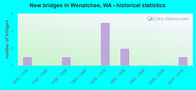
- New bridges - historical statistics
- 11930-1939
- 11950-1959
- 51970-1979
- 21980-1989
- 12010-2019
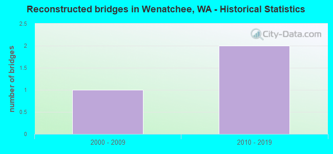
- Reconstructed bridges - Historical Statistics
- 12000-2009
- 22010-2019
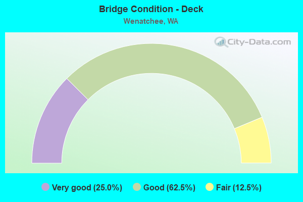
- Bridge Condition - Deck
- 25.0%Very good
- 62.5%Good
- 12.5%Fair
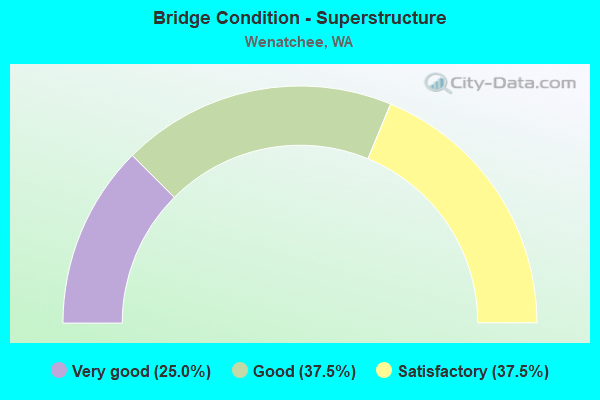
- Bridge Condition - Superstructure
- 25.0%Very good
- 37.5%Good
- 37.5%Satisfactory
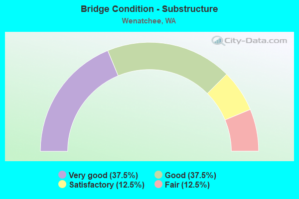
- Bridge Condition - Substructure
- 37.5%Very good
- 37.5%Good
- 12.5%Satisfactory
- 12.5%Fair
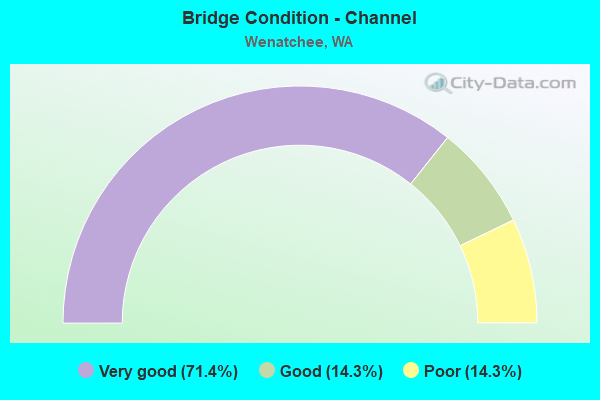
- Bridge Condition - Channel
- 71.4%Very good
- 14.3%Good
- 14.3%Poor
Find on map >> Show street view
Structure Number: 82453, Location: 3. W WENATCHEE C.L (Lat: 47.471750, Lng: -120.372222), Route carried "on" structure: County highway 25840, Year Built: 1988, Status: Open, Structure Length: 11.80m (38.71ft), Average Daily Traffic: 601 (year 2019), Truck Traffic: 3%, Average Future Daily Traffic: 754 (year 2039), Design Load: HS 20, Features Intersected: WENATCHEE RIVER, Facility Carried by Structure: SLEEPY HOLLOW ROAD
Minimum Vertical Clearance: 30+ m (98+ ft), Kilometerpoint: 0.001, Lanes on structure: 2, Owner: County Highway Agency, Approaching Roadway Width: 10.4m (34.1ft), Material/Design: Prestressed concrete continuous, Design/Construction: Stringer/Multi-beam, Number Of Spans In Main Unit: 3, Length of Maximum Span: 39.3m (128.9ft), Curb-To-Curb Width: 9.8m (32.2ft), Out-to-Out Width: 10.4m (34.1ft)
Condition: Deck: Good, Superstructure: Good, Substructure: Good, Channel: Good, Operating Rating: 78.4 metric tons, Method Used To Determine Operating Rating: Load and Resistance Factor Rating (LRFR) rating reported by rating factor(RF) method using HL-93 loadings, Inventory Rating: 42.4 metric tons, Method Used To Determine Inventory Rating: Load and Resistance Factor Rating (LRFR) rating reported by rating factor(RF) method using HL-93 loadings, Structural Evaluation: Better than present minimum criteria, Deck Geometry: Equal to present minimum criteria, Waterway Adequacy: Equal to present desirable criteria, Approach Roadway Alignment: Equal to present desirable criteria, Length Of Structure Improvement: 12.10m (39.70ft), Designated Inspection Frequency: Every 24 months, Underwater Inspection Frequency: Every 60 months, Inspection Date: August 2021, Underwater Inspection Date: September 2018, Bridge Improvement Cost: $6,034,000, Roadway Improvement Cost: $1,207,000, Total Project Cost: $12,069,000 ( Estimate for 2014), Deck Structure Type: Concrete Cast-file-Place, Wearing Surface/Protective System: Wearing Surface: Monolithic Concrete, Deck Protection: Epoxy Coated Reinforcing
Find on map >> Show street view
Structure Number: 82544, Location: 2.7 from S. WENATCHEE AV (Lat: 47.378333, Lng: -120.246667), Route carried "on" structure: County highway 91300, Year Built: 1951, Status: Posted for load, Structure Length: 1.34m (4.40ft), Average Daily Traffic: 5,578 (year 2019), Truck Traffic: 7%, Average Future Daily Traffic: 6,930 (year 2039), Design Load: HS 20, Features Intersected: STEMILT CR., Facility Carried by Structure: MALAGA-ALCOA HWY
Minimum Vertical Clearance: 30+ m (98+ ft), Kilometerpoint: 0.001, Lanes on structure: 2, Owner: County Highway Agency, Approaching Roadway Width: 11.9m (39.0ft), Material/Design: Concrete continuous, Design/Construction: Slab, Number Of Spans In Main Unit: 3, Length of Maximum Span: 9.1m (29.9ft), Curb-To-Curb Width: 8.5m (27.9ft), Out-to-Out Width: 9.1m (29.9ft)
Condition: Deck: Good, Superstructure: Good, Substructure: Satisfactory, Channel: Very good, Operating Rating: 23.3 metric tons, Method Used To Determine Operating Rating: Load and Resistance Factor Rating (LRFR) rating reported by rating factor(RF) method using HL-93 loadings, Inventory Rating: 18.1 metric tons, Method Used To Determine Inventory Rating: Load and Resistance Factor Rating (LRFR) rating reported by rating factor(RF) method using HL-93 loadings, Structural Evaluation: Meets minimum limits, Deck Geometry: High priority of replacement, Waterway Adequacy: Equal to present minimum criteria, Approach Roadway Alignment: Equal to present desirable criteria, Bridge Posting: Required (Relationship of Operating Rating to Maximum Legal Load: 10.0 - 19.9% below), Length Of Structure Improvement: 1.65m (5.41ft), Designated Inspection Frequency: Every 24 months, Inspection Date: October 2020, Bridge Improvement Cost: $821,000, Roadway Improvement Cost: $164,000, Total Project Cost: $1,642,000 ( Estimate for 2014), Deck Structure Type: Concrete Cast-file-Place, Wearing Surface/Protective System: Wearing Surface: Monolithic Concrete
Find on map >> Show street view
Structure Number: 82635, Location: 14.34S/W WENATCHEE (Lat: 47.298333, Lng: -120.103333), Route carried "on" structure: County highway 19550, Year Built: 1976, Year Reconstructed: 2016, Status: Open, Structure Length: 1.10m (3.61ft), Average Daily Traffic: 161 (year 2019), Truck Traffic: 7%, Average Future Daily Traffic: 201 (year 2039), Design Load: HS 20+Mod, Features Intersected: COLOCKUM CREEK
Minimum Vertical Clearance: 30+ m (98+ ft), Kilometerpoint: 0.001, Lanes on structure: 2, Owner: County Highway Agency, Approaching Roadway Width: 7.9m (25.9ft), Material/Design: Prestressed concrete, Design/Construction: Stringer/Multi-beam, Number Of Spans In Main Unit: 1, Length of Maximum Span: 10.7m (35.1ft), Curb-To-Curb Width: 7.2m (23.6ft), Out-to-Out Width: 7.3m (24.0ft)
Condition: Deck: Very good, Superstructure: Very good, Substructure: Very good, Channel: Very good, Operating Rating: 28.5 metric tons, Method Used To Determine Operating Rating: Load and Resistance Factor Rating (LRFR) rating reported by rating factor(RF) method using HL-93 loadings, Inventory Rating: 10.4 metric tons, Method Used To Determine Inventory Rating: Load and Resistance Factor Rating (LRFR) rating reported by rating factor(RF) method using HL-93 loadings, Structural Evaluation: High priority of corrective action, Deck Geometry: Meets minimum limits, Waterway Adequacy: Somewhat better than minimum adequacy, Approach Roadway Alignment: Equal to present minimum criteria, Length Of Structure Improvement: 1.10m (3.61ft), Designated Inspection Frequency: Every 24 months, Inspection Date: October 2021, Bridge Improvement Cost: $202,000, Roadway Improvement Cost: $40,000, Total Project Cost: $403,000 ( Estimate for 2014), Deck Structure Type: Other, Wearing Surface/Protective System: Wearing Surface: Bituminous, Membrane: Preformed Fabric
Find on map >> Show street view
Structure Number: 8468, Location: 12.0 S OF MALAGA (Lat: 47.273333, Lng: -120.181667), Route carried "on" structure: County highway 19390, Year Built: 1979, Year Reconstructed: 2016, Status: Open, Structure Length: 0.98m (3.22ft), Average Daily Traffic: 50 (year 2019), Truck Traffic: 12%, Average Future Daily Traffic: 63 (year 2039), Design Load: H 20, Features Intersected: COLOCKUM CREEK, Facility Carried by Structure: COLOCKUM PASS RD
Minimum Vertical Clearance: 30+ m (98+ ft), Kilometerpoint: 0.001, Lanes on structure: 2, Owner: County Highway Agency, Approaching Roadway Width: 7.3m (24.0ft), Material/Design: Prestressed concrete, Design/Construction: Tee Beam, Number Of Spans In Main Unit: 1, Length of Maximum Span: 9.1m (29.9ft), Curb-To-Curb Width: 7.3m (24.0ft), Out-to-Out Width: 7.3m (24.0ft)
Condition: Deck: Good, Superstructure: Good, Substructure: Very good, Channel: Very good, Operating Rating: 44.4 metric tons, Method Used To Determine Operating Rating: Allowable Stress (AS), Inventory Rating: 26.3 metric tons, Method Used To Determine Inventory Rating: Allowable Stress (AS), Structural Evaluation: Equal to present minimum criteria, Deck Geometry: Equal to present minimum criteria, Waterway Adequacy: Better than present minimum criteria, Approach Roadway Alignment: Equal to present desirable criteria, Length Of Structure Improvement: 0.98m (3.22ft), Designated Inspection Frequency: Every 24 months, Inspection Date: October 2021, Bridge Improvement Cost: $166,000, Roadway Improvement Cost: $33,000, Total Project Cost: $333,000 ( Estimate for 2014), Deck Structure Type: Other, Wearing Surface/Protective System: Wearing Surface: Monolithic Concrete
Find on map >> Show street view
Structure Number: 85134, Location: APPLELAND DR (Lat: 47.413333, Lng: -120.326667), Route carried "on" structure: City street 14050, Year Built: 1975, Status: Posted for load, Structure Length: 0.91m (2.99ft), Average Daily Traffic: 453 (year 2018), Truck Traffic: 5%, Average Future Daily Traffic: 660 (year 2040), Design Load: HS 20, Features Intersected: WEN REC IRRIG CANAL, Facility Carried by Structure: MILLERDALE AVE
Minimum Vertical Clearance: 30+ m (98+ ft), Kilometerpoint: 0.001, Lanes on structure: 2, Owner: City or Municipal Highway Agency, Approaching Roadway Width: 11.0m (36.1ft), Material/Design: Prestressed concrete, Design/Construction: Stringer/Multi-beam, Number Of Spans In Main Unit: 1, Length of Maximum Span: 8.5m (27.9ft), Curb or Sidewalk Widths: Left: 1.2m (3.9ft), Right: 1.2m (3.9ft), Curb-To-Curb Width: 10.5m (34.4ft), Out-to-Out Width: 13.6m (44.6ft)
Condition: Deck: Good, Superstructure: Satisfactory, Substructure: Good, Channel: Very good, Operating Rating: 34.0 metric tons, Method Used To Determine Operating Rating: Load and Resistance Factor Rating (LRFR) rating reported by rating factor(RF) method using HL-93 loadings, Inventory Rating: 26.2 metric tons, Method Used To Determine Inventory Rating: Load and Resistance Factor Rating (LRFR) rating reported by rating factor(RF) method using HL-93 loadings, Structural Evaluation: Equal to present minimum criteria, Deck Geometry: Equal to present minimum criteria, Waterway Adequacy: Equal to present desirable criteria, Approach Roadway Alignment: Equal to present minimum criteria, Bridge Posting: Required (Relationship of Operating Rating to Maximum Legal Load: 10.0 - 19.9% below), Length Of Structure Improvement: 1.22m (4.00ft), Designated Inspection Frequency: Every 24 months, Inspection Date: October 2020, Bridge Improvement Cost: $608,000, Roadway Improvement Cost: $122,000, Total Project Cost: $1,216,000 ( Estimate for 2014), Deck Structure Type: Concrete Precast Panels, Wearing Surface/Protective System: Wearing Surface: Monolithic Concrete
Find on map >> Show street view
Structure Number: 85169, Location: 0.5 N JCT SR 28 (Lat: 47.409681, Lng: -120.299828), Route carried "on" structure: State highway 285, Year Built: 1973, Year Reconstructed: 2013, Status: Open, Structure Length: 3.96m (12.99ft), Average Daily Traffic: 47,445 (year 2019), Truck Traffic: 3%, Average Future Daily Traffic: 59,590 (year 2039), Design Load: HS 20+Mod, Features Intersected: S WENATCHEE AVE
Minimum Vertical Clearance: 30+ m (98+ ft), Kilometerpoint: 0.756, Lanes on structure: 6, Lanes under structure: 3, Base Highway Network: Yes, Owner: State Highway Agency, Approaching Roadway Width: 24.4m (80.1ft), Material/Design: Prestressed concrete, Design/Construction: Box Beam or Girders - Multiple, Number Of Spans In Main Unit: 1, Length of Maximum Span: 38.7m (127.0ft), Curb-To-Curb Width: 24.4m (80.1ft), Out-to-Out Width: 25.1m (82.3ft)
Condition: Deck: Good, Superstructure: Satisfactory, Substructure: Good, Operating Rating: 53.1 metric tons, Method Used To Determine Operating Rating: Load and Resistance Factor Rating (LRFR) rating reported by rating factor(RF) method using HL-93 loadings, Inventory Rating: 25.6 metric tons, Method Used To Determine Inventory Rating: Load and Resistance Factor Rating (LRFR) rating reported by rating factor(RF) method using HL-93 loadings, Structural Evaluation: Equal to present minimum criteria, Deck Geometry: Meets minimum limits, Underclear: Meets minimum limits, Approach Roadway Alignment: Equal to present desirable criteria, Length Of Structure Improvement: 3.96m (12.99ft), Designated Inspection Frequency: Every 48 months, Inspection Date: July 2018, Bridge Improvement Cost: $2,132,000, Roadway Improvement Cost: $426,000, Total Project Cost: $4,264,000 ( Estimate for 2014), Deck Structure Type: Concrete Cast-file-Place, Wearing Surface/Protective System: Wearing Surface: Latex Concrete
Find on map >> Show street view
Structure Number: 85629, Location: 00.2 N EASY ST (Lat: 47.478333, Lng: -120.355000), Route carried "on" structure: County highway 45230, Year Built: 1987, Status: Open, Structure Length: 1.16m (3.81ft), Average Daily Traffic: 1,931 (year 2019), Truck Traffic: 9%, Average Future Daily Traffic: 2,200 (year 2039), Design Load: HS 20, Features Intersected: HIGHLINE CANAL
Minimum Vertical Clearance: 30+ m (98+ ft), Kilometerpoint: 0.001, Lanes on structure: 2, Owner: County Highway Agency, Approaching Roadway Width: 11.6m (38.1ft), Skew: 2 degrees, Material/Design: Prestressed concrete, Design/Construction: Tee Beam, Number Of Spans In Main Unit: 1, Length of Maximum Span: 11.6m (38.1ft), Curb-To-Curb Width: 9.1m (29.9ft), Out-to-Out Width: 9.8m (32.2ft)
Condition: Deck: Very good, Superstructure: Very good, Substructure: Very good, Channel: Very good, Operating Rating: 51.8 metric tons, Method Used To Determine Operating Rating: Load and Resistance Factor Rating (LRFR) rating reported by rating factor(RF) method using HL-93 loadings, Inventory Rating: 36.9 metric tons, Method Used To Determine Inventory Rating: Load and Resistance Factor Rating (LRFR) rating reported by rating factor(RF) method using HL-93 loadings, Structural Evaluation: Equal to present desirable criteria, Deck Geometry: Somewhat better than minimum adequacy, Waterway Adequacy: Equal to present desirable criteria, Approach Roadway Alignment: Equal to present desirable criteria, Length Of Structure Improvement: 1.46m (4.79ft), Designated Inspection Frequency: Every 24 months, Inspection Date: October 2020, Bridge Improvement Cost: $730,000, Roadway Improvement Cost: $146,000, Total Project Cost: $1,459,000 ( Estimate for 2014), Deck Structure Type: Other, Wearing Surface/Protective System: Wearing Surface: Low Slump Concrete, Deck Protection: Epoxy Coated Reinforcing
Find on map >> Show street view
Structure Number: 88863, Location: 300' FROM STEMILT CRK RD (Lat: 47.374878, Lng: -120.249539), Route carried "on" structure: Alternate County highway 16360, Year Built: 1936, Status: Posted for load, Structure Length: 0.98m (3.22ft), Average Daily Traffic: 2 (year 2021), Average Future Daily Traffic: 2 (year 2041), Features Intersected: STEMILT CREEK, Facility Carried by Structure: OLD WEST MALAGA RD
Minimum Vertical Clearance: 30+ m (98+ ft), Kilometerpoint: 0.001, Lanes on structure: 1, Owner: County Highway Agency, Approaching Roadway Width: 4.0m (13.1ft), Skew: 2 degrees, Material/Design: Concrete, Design/Construction: Girder and Floorbeam System, Number Of Spans In Main Unit: 1, Length of Maximum Span: 9.1m (29.9ft), Curb-To-Curb Width: 6.1m (20.0ft), Out-to-Out Width: 6.9m (22.6ft)
Condition: Deck: Fair, Superstructure: Satisfactory, Substructure: Fair, Channel: Poor, Operating Rating: 23.0 metric tons, Method Used To Determine Operating Rating: Load and Resistance Factor Rating (LRFR) rating reported by rating factor(RF) method using HL-93 loadings, Inventory Rating: 17.8 metric tons, Method Used To Determine Inventory Rating: Load and Resistance Factor Rating (LRFR) rating reported by rating factor(RF) method using HL-93 loadings, Structural Evaluation: Somewhat better than minimum adequacy, Deck Geometry: Somewhat better than minimum adequacy, Waterway Adequacy: Better than present minimum criteria, Approach Roadway Alignment: Equal to present desirable criteria, Bridge Posting: Required (Relationship of Operating Rating to Maximum Legal Load: 10.0 - 19.9% below), Length Of Structure Improvement: 1.28m (4.20ft), Designated Inspection Frequency: Every 24 months, Inspection Date: October 2021, Bridge Improvement Cost: $437,000, Roadway Improvement Cost: $87,000, Total Project Cost: $874,000 ( Estimate for 2014), Deck Structure Type: Concrete Cast-file-Place, Wearing Surface/Protective System: Wearing Surface: Bituminous
Find on map >> Show street view
Structure Number: 18310A, Location: 0.5 N JCT SR 28 (Lat: 47.409556, Lng: -120.300083), Route carried "under" structure: City street 285, Year Built: 2013, Structure Length: 0. m, Average Daily Traffic: 5,900 (year 2016), Features Intersected: S WENATCHEE AVE, Facility Carried by Structure: PED TRAIL
Minimum Vertical Clearance: 5.46m (17.91ft), Kilometerpoint: 0.113, Lanes under structure: 3, Material/Design: Prestressed concrete, Design/Construction: Box Beam or Girders - Single/Spread, Length of Maximum Span: 38.4m (126.0ft)
Find on map >> Show street view
Structure Number: 85169, Location: 0.5 N JCT SR 28 (Lat: 47.409681, Lng: -120.299828), Route carried "under" structure: City street , Year Built: 1973, Structure Length: 0. m, Average Daily Traffic: 20,103 (year 2012), Truck Traffic: 7%, Features Intersected: S WENATCHEE AVE, Facility Carried by Structure: SR 285
Minimum Vertical Clearance: 5.26m (17.26ft), Kilometerpoint: 0.129, Lanes on structure: 6, Lanes under structure: 3, Material/Design: Prestressed concrete, Design/Construction: Box Beam or Girders - Multiple, Length of Maximum Span: 38.7m (127.0ft)