Bridge Statistics for West Baden Springs, Indiana (IN)
Condition, Traffic, Stress, Structural Evaluation, Project Costs
- National Bridge Inventory (NBI) Statistics
- 17Number of bridges
- 217ft / 66.2mTotal length
- $1,300,000Total costs
- 37,645Total average daily traffic
- 4,895Total average daily truck traffic
- 52,939Total future (year 2030) average daily traffic
- National Bridge Inventory (NBI) Registered Bridges for West Baden Springs
- No street view available for this location
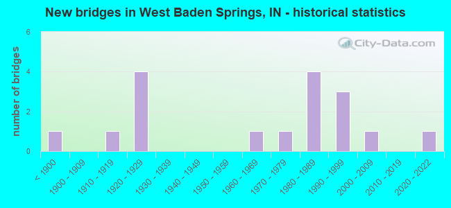
- New bridges - historical statistics
- 1Before 1900
- 11910-1919
- 41920-1929
- 11960-1969
- 11970-1979
- 41980-1989
- 31990-1999
- 12000-2009
- 12020-2022

- Reconstructed bridges - Historical Statistics
- 11960-1969
- 01970-1979
- 01980-1989
- 01990-1999
- 42000-2009


- Bridge Condition - Deck
- 7.7%Very good
- 76.9%Good
- 7.7%Fair
- 7.7%Poor

- Bridge Condition - Superstructure
- 14.3%Very good
- 42.9%Good
- 21.4%Satisfactory
- 14.3%Fair
- 7.1%Serious

- Bridge Condition - Substructure
- 21.4%Very good
- 35.7%Good
- 21.4%Satisfactory
- 14.3%Fair
- 7.1%Poor

- Bridge Condition - Channel
- 5.9%Excellent
- 5.9%Very good
- 29.4%Good
- 35.3%Satisfactory
- 11.8%Fair
- 11.8%Poor

- Bridge Condition - Culverts
- 33.3%Excellent
- 66.7%Satisfactory
Find on map >> Show street view
Structure Number: 2012, Location: 00.40 W US 150 (Lat: 38.573411, Lng: -86.613331), Route carried "on" structure: State highway 56, Year Built: 1923, Year Reconstructed: 2012, Status: Open, Structure Length: 7.07m (23.20ft), Average Daily Traffic: 11,870 (year 2010), Truck Traffic: 14%, Average Future Daily Traffic: 17,090 (year 2030), Design Load: H 20, Features Intersected: LOST RIVER
Minimum Vertical Clearance: 30+ m (98+ ft), Kilometerpoint: 9.946, Lanes on structure: 2, Owner: State Highway Agency, Approaching Roadway Width: 8.5m (27.9ft), Skew: 3 degrees, Material/Design: Concrete, Design/Construction: Arch - Deck, Number Of Spans In Main Unit: 2, Length of Maximum Span: 25.0m (82.0ft), Curb or Sidewalk Widths: Left: 3.0m (9.8ft), Right: 0.0m, Curb-To-Curb Width: 9.2m (30.2ft), Out-to-Out Width: 13.4m (44.0ft)
Condition: Superstructure: Satisfactory, Substructure: Satisfactory, Channel: Satisfactory, Operating Rating: 81.6 metric tons, Method Used To Determine Operating Rating: Field evaluation and documented engineering judgment, Inventory Rating: 48.9 metric tons, Method Used To Determine Inventory Rating: Field evaluation and documented engineering judgment, Structural Evaluation: Equal to present minimum criteria, Deck Geometry: Meets minimum limits, Waterway Adequacy: Better than present minimum criteria, Approach Roadway Alignment: Equal to present desirable criteria, Designated Inspection Frequency: Every 24 months, Inspection Date: September 2020
Find on map >> Show street view
Structure Number: 2745, Location: 03.31 W SR 56 (Lat: 38.586650, Lng: -86.664311), Route carried "on" structure: US 150, Year Built: 1971, Year Reconstructed: 2014, Status: Open, Structure Length: 7.38m (24.21ft), Average Daily Traffic: 900 (year 2010), Truck Traffic: 24%, Average Future Daily Traffic: 1,628 (year 2034), Design Load: HS 20, Features Intersected: LOST RIVER
Minimum Vertical Clearance: 30+ m (98+ ft), Kilometerpoint: 1.963, Lanes on structure: 2, Owner: State Highway Agency, Approaching Roadway Width: 8.5m (27.9ft), Material/Design: Prestressed concrete continuous, Design/Construction: Box Beam or Girders - Multiple, Number Of Spans In Main Unit: 5, Length of Maximum Span: 14.8m (48.6ft), Curb-To-Curb Width: 13.4m (44.0ft), Out-to-Out Width: 14.2m (46.6ft)
Condition: Deck: Good, Superstructure: Satisfactory, Substructure: Good, Channel: Satisfactory, Operating Rating: 44.7 metric tons, Method Used To Determine Operating Rating: Load and Resistance Factor Rating (LRFR) rating reported by rating factor(RF) method using HL-93 loadings, Inventory Rating: 34.3 metric tons, Method Used To Determine Inventory Rating: Load and Resistance Factor Rating (LRFR) rating reported by rating factor(RF) method using HL-93 loadings, Structural Evaluation: Equal to present minimum criteria, Deck Geometry: Superior to present desirable criteria, Waterway Adequacy: Equal to present desirable criteria, Approach Roadway Alignment: Equal to present desirable criteria, Designated Inspection Frequency: Every 24 months, Inspection Date: October 2020, Deck Structure Type: Concrete Cast-file-Place, Wearing Surface/Protective System: Wearing Surface: Integral Concrete, Deck Protection: Epoxy Coated Reinforcing
Find on map >> Show street view
Structure Number: 27461, Location: 01.62 W SR 56 (Lat: 38.588811, Lng: -86.636850), Route carried "on" structure: US 150, Year Built: 2021, Status: Open, Structure Length: 2.22m (7.28ft), Average Daily Traffic: 1,320 (year 2021), Truck Traffic: 26%, Average Future Daily Traffic: 1,360 (year 2041), Design Load: HL 93, Features Intersected: KANIE CREEK
Minimum Vertical Clearance: 30+ m (98+ ft), Kilometerpoint: 4.683, Lanes on structure: 2, Owner: State Highway Agency, Approaching Roadway Width: 9.8m (32.2ft), Skew: 3 degrees, Material/Design: Concrete, Design/Construction: Culvert, Number Of Spans In Main Unit: 1, Length of Maximum Span: 21.1m (69.2ft), Curb-To-Curb Width: 10.5m (34.4ft), Out-to-Out Width: 10.7m (35.1ft)
Condition: Channel: Excellent, Culverts: Excellent, Operating Rating: 67.7 metric tons, Method Used To Determine Operating Rating: Load and Resistance Factor Rating (LRFR) rating reported by rating factor(RF) method using HL-93 loadings, Inventory Rating: 49.6 metric tons, Method Used To Determine Inventory Rating: Load and Resistance Factor Rating (LRFR) rating reported by rating factor(RF) method using HL-93 loadings, Structural Evaluation: Superior to present desirable criteria, Deck Geometry: Equal to present minimum criteria, Waterway Adequacy: Superior to present desirable criteria, Approach Roadway Alignment: Equal to present desirable criteria, Designated Inspection Frequency: Every 24 months, Inspection Date: November 2021, Wearing Surface/Protective System: Wearing Surface: Bituminous
Find on map >> Show street view
Structure Number: 2747, Location: 01.36 W SR 56 (Lat: 38.585981, Lng: -86.634100), Route carried "on" structure: US 150, Year Built: 1963, Year Reconstructed: 2014, Status: Open, Structure Length: 6.92m (22.70ft), Average Daily Traffic: 1,900 (year 2011), Truck Traffic: 16%, Average Future Daily Traffic: 2,310 (year 2033), Design Load: HS 20, Features Intersected: LOST RIVER
Minimum Vertical Clearance: 30+ m (98+ ft), Kilometerpoint: 5.102, Lanes on structure: 2, Owner: State Highway Agency, Approaching Roadway Width: 7.9m (25.9ft), Material/Design: Steel continuous, Design/Construction: Stringer/Multi-beam, Number Of Spans In Main Unit: 3, Length of Maximum Span: 25.8m (84.6ft), Curb or Sidewalk Widths: Left: 0.6m (2.0ft), Right: 0.6m (2.0ft), Curb-To-Curb Width: 9.1m (29.9ft), Out-to-Out Width: 11.1m (36.4ft)
Condition: Deck: Good, Superstructure: Good, Substructure: Good, Channel: Good, Operating Rating: 39.2 metric tons, Method Used To Determine Operating Rating: Load and Resistance Factor Rating (LRFR) rating reported by rating factor(RF) method using HL-93 loadings, Inventory Rating: 30.1 metric tons, Method Used To Determine Inventory Rating: Load and Resistance Factor Rating (LRFR) rating reported by rating factor(RF) method using HL-93 loadings, Structural Evaluation: Better than present minimum criteria, Deck Geometry: Somewhat better than minimum adequacy, Waterway Adequacy: Superior to present desirable criteria, Approach Roadway Alignment: Equal to present desirable criteria, Designated Inspection Frequency: Every 24 months, Inspection Date: October 2020, Deck Structure Type: Concrete Cast-file-Place, Wearing Surface/Protective System: Wearing Surface: Monolithic Concrete, Deck Protection: Epoxy Coated Reinforcing
Find on map >> Show street view
Structure Number: 2748, Location: 00.77 E SR 56 (Lat: 38.581269, Lng: -86.598689), Route carried "on" structure: US 150, Year Built: 2005, Status: Open, Structure Length: 6.49m (21.29ft), Average Daily Traffic: 5,365 (year 2004), Truck Traffic: 10%, Average Future Daily Traffic: 7,431 (year 2032), Design Load: HS 20+Mod, Features Intersected: LOST RIVER
Minimum Vertical Clearance: 30+ m (98+ ft), Kilometerpoint: 8.530, Lanes on structure: 2, Owner: State Highway Agency, Approaching Roadway Width: 13.4m (44.0ft), Skew: 2 degrees, Material/Design: Prestressed concrete continuous, Design/Construction: Stringer/Multi-beam, Number Of Spans In Main Unit: 3, Length of Maximum Span: 22.4m (73.5ft), Curb-To-Curb Width: 13.6m (44.6ft), Out-to-Out Width: 14.5m (47.6ft)
Condition: Deck: Good, Superstructure: Good, Substructure: Good, Channel: Very good, Operating Rating: 43.1 metric tons, Method Used To Determine Operating Rating: Load and Resistance Factor Rating (LRFR) rating reported by rating factor(RF) method using HL-93 loadings, Inventory Rating: 33.0 metric tons, Method Used To Determine Inventory Rating: Load and Resistance Factor Rating (LRFR) rating reported by rating factor(RF) method using HL-93 loadings, Structural Evaluation: Better than present minimum criteria, Deck Geometry: Superior to present desirable criteria, Waterway Adequacy: Equal to present desirable criteria, Approach Roadway Alignment: Equal to present desirable criteria, Designated Inspection Frequency: Every 24 months, Inspection Date: December 2020, Deck Structure Type: Concrete Cast-file-Place, Wearing Surface/Protective System: Wearing Surface: Monolithic Concrete, Deck Protection: Epoxy Coated Reinforcing
Find on map >> Show street view
Structure Number: 275, Location: 02.71 E SR 56 (Lat: 38.576969, Lng: -86.566681), Route carried "on" structure: US 150, Year Built: 1923, Year Reconstructed: 2014, Status: Open, Structure Length: 4.82m (15.81ft), Average Daily Traffic: 8,180 (year 2011), Truck Traffic: 14%, Average Future Daily Traffic: 12,810 (year 2031), Design Load: H 20, Features Intersected: LICK CREEK
Minimum Vertical Clearance: 30+ m (98+ ft), Kilometerpoint: 11.652, Lanes on structure: 2, Owner: State Highway Agency, Approaching Roadway Width: 8.5m (27.9ft), Material/Design: Concrete, Design/Construction: Culvert, Number Of Spans In Main Unit: 2, Number Of Approach Spans: 2, Length of Maximum Span: 18.3m (60.0ft), Curb or Sidewalk Widths: Left: 0.3m (1.0ft), Right: 0.3m (1.0ft), Curb-To-Curb Width: 9.9m (32.5ft), Out-to-Out Width: 10.5m (34.4ft)
Condition: Channel: Good, Culverts: Satisfactory, Operating Rating: 60.4 metric tons, Method Used To Determine Operating Rating: Field evaluation and documented engineering judgment, Inventory Rating: 36.1 metric tons, Method Used To Determine Inventory Rating: Field evaluation and documented engineering judgment, Structural Evaluation: Equal to present minimum criteria, Deck Geometry: Meets minimum limits, Waterway Adequacy: Superior to present desirable criteria, Approach Roadway Alignment: Equal to present desirable criteria, Designated Inspection Frequency: Every 24 months, Inspection Date: December 2020
Find on map >> Show street view
Structure Number: 2751, Location: 03.70 E SR 56 (Lat: 38.573269, Lng: -86.550919), Route carried "on" structure: US 150, Year Built: 1927, Year Reconstructed: 1968, Status: Open, Structure Length: 1.46m (4.79ft), Average Daily Traffic: 5,365 (year 2004), Truck Traffic: 10%, Average Future Daily Traffic: 7,431 (year 2030), Design Load: H 20, Features Intersected: MYSTERIOUS SPRING
Minimum Vertical Clearance: 30+ m (98+ ft), Kilometerpoint: 13.245, Lanes on structure: 2, Owner: State Highway Agency, Approaching Roadway Width: 8.5m (27.9ft), Material/Design: Concrete, Design/Construction: Culvert, Number Of Spans In Main Unit: 1, Length of Maximum Span: 11.0m (36.1ft), Curb or Sidewalk Widths: Left: 0.3m (1.0ft), Right: 0.3m (1.0ft), Curb-To-Curb Width: 10.1m (33.1ft), Out-to-Out Width: 10.7m (35.1ft)
Condition: Channel: Good, Culverts: Satisfactory, Operating Rating: 39.8 metric tons, Method Used To Determine Operating Rating: Field evaluation and documented engineering judgment, Inventory Rating: 23.9 metric tons, Method Used To Determine Inventory Rating: Field evaluation and documented engineering judgment, Structural Evaluation: Somewhat better than minimum adequacy, Deck Geometry: Meets minimum limits, Waterway Adequacy: Superior to present desirable criteria, Approach Roadway Alignment: Equal to present desirable criteria, Designated Inspection Frequency: Every 24 months, Inspection Date: December 2020
Find on map >> Show street view
Structure Number: 590001, Location: 0.60 N OF CR 375 N (Lat: 38.616419, Lng: -86.648219), Route carried "on" structure: Alternate County highway 44, Year Built: 1910, Status: Posted for load, Structure Length: 2.55m (8.37ft), Average Daily Traffic: 100 (year 2014), Truck Traffic: 5%, Average Future Daily Traffic: 180 (year 2034), Features Intersected: SULPHUR CREEK, Facility Carried by Structure: CR 390 NORTH
Minimum Vertical Clearance: 30+ m (98+ ft), Kilometerpoint: 0.000, Lanes on structure: 1, Owner: County Highway Agency, Approaching Roadway Width: 4.3m (14.1ft), Material/Design: Steel, Design/Construction: Truss - Thru, Number Of Spans In Main Unit: 1, Number Of Approach Spans: 1, Length of Maximum Span: 17.5m (57.4ft), Curb-To-Curb Width: 3.5m (11.5ft), Out-to-Out Width: 3.6m (11.8ft)
Condition: Deck: Poor, Superstructure: Serious, Substructure: Poor, Channel: Fair, Operating Rating: 6.2 metric tons, Method Used To Determine Operating Rating: Load Factor (LF), Inventory Rating: 3.7 metric tons, Method Used To Determine Inventory Rating: Load Factor (LF), Structural Evaluation: High priority of replacement, Deck Geometry: High priority of corrective action, Waterway Adequacy: High priority of corrective action, Approach Roadway Alignment: High priority of corrective action, Bridge Posting: Required (Relationship of Operating Rating to Maximum Legal Load: > 39.9% below), Length Of Structure Improvement: 3.05m (10.01ft), Designated Inspection Frequency: Every 12 months, Critical Feature Inspection Frequency: Every 24 months, Other Special Inspection Frequency: Every 24 months, Inspection Date: May 2021, Critical Feature Inspection Date: May 2020, Other Special Inspection Date: May 2021, Bridge Improvement Cost: $400,000, Roadway Improvement Cost: $200,000, Total Project Cost: $600,000 ( Estimate for 2021), Deck Structure Type: Concrete Cast-file-Place, Wearing Surface/Protective System: Wearing Surface: Integral Concrete
Find on map >> Show street view
Structure Number: 5900011, Location: 0.10 N OF CR 500 N (Lat: 38.628011, Lng: -86.632311), Route carried "on" structure: Alternate County highway 272, Year Built: 1993, Status: Open, Structure Length: 0.85m (2.79ft), Average Daily Traffic: 10 (year 2014), Truck Traffic: 5%, Average Future Daily Traffic: 15 (year 2034), Features Intersected: SULPHUR CREEK, Facility Carried by Structure: CR 500 NORTH
Minimum Vertical Clearance: 30+ m (98+ ft), Kilometerpoint: 0.000, Lanes on structure: 1, Owner: County Highway Agency, Approaching Roadway Width: 3.7m (12.1ft), Material/Design: Steel, Design/Construction: Stringer/Multi-beam, Number Of Spans In Main Unit: 1, Length of Maximum Span: 6.4m (21.0ft), Curb-To-Curb Width: 4.3m (14.1ft), Out-to-Out Width: 4.3m (14.1ft)
Condition: Deck: Good, Superstructure: Good, Substructure: Fair, Channel: Poor, Operating Rating: 58.6 metric tons, Method Used To Determine Operating Rating: Load Factor (LF), Inventory Rating: 35.1 metric tons, Method Used To Determine Inventory Rating: Load Factor (LF), Structural Evaluation: Somewhat better than minimum adequacy, Deck Geometry: Equal to present minimum criteria, Waterway Adequacy: High priority of replacement, Approach Roadway Alignment: High priority of corrective action, Designated Inspection Frequency: Every 24 months, Inspection Date: May 2020, Deck Structure Type: Open Grating, Wearing Surface/Protective System: Wearing Surface: Other
Find on map >> Show street view
Structure Number: 5900012, Location: 0.20 E OF CR 710 W (Lat: 38.607569, Lng: -86.586500), Route carried "on" structure: Alternate County highway 17, Year Built: 1983, Status: Open, Structure Length: 5.22m (17.13ft), Average Daily Traffic: 779 (year 2019), Truck Traffic: 5%, Average Future Daily Traffic: 105 (year 2039), Design Load: HS 20, Features Intersected: LOST RIVER, Facility Carried by Structure: CR 350 NORTH
Minimum Vertical Clearance: 30+ m (98+ ft), Kilometerpoint: 0.000, Lanes on structure: 2, Owner: County Highway Agency, Approaching Roadway Width: 7.0m (23.0ft), Material/Design: Steel continuous, Design/Construction: Stringer/Multi-beam, Number Of Spans In Main Unit: 3, Length of Maximum Span: 24.3m (79.7ft), Curb-To-Curb Width: 7.3m (24.0ft), Out-to-Out Width: 8.0m (26.2ft)
Condition: Deck: Good, Superstructure: Very good, Substructure: Very good, Channel: Satisfactory, Operating Rating: 76.9 metric tons, Method Used To Determine Operating Rating: Load Factor (LF), Inventory Rating: 46.0 metric tons, Method Used To Determine Inventory Rating: Load Factor (LF), Structural Evaluation: Equal to present desirable criteria, Deck Geometry: Meets minimum limits, Waterway Adequacy: Meets minimum limits, Approach Roadway Alignment: Equal to present desirable criteria, Designated Inspection Frequency: Every 24 months, Inspection Date: May 2020, Deck Structure Type: Concrete Cast-file-Place, Wearing Surface/Protective System: Wearing Surface: Integral Concrete
Find on map >> Show street view
Structure Number: 5900013, Location: 0.20 E OF CR 775 W (Lat: 38.612150, Lng: -86.598619), Route carried "on" structure: Alternate County highway 228, Year Built: 1894, Status: Posted for load, Structure Length: 3.08m (10.10ft), Average Daily Traffic: 125 (year 2014), Truck Traffic: 5%, Average Future Daily Traffic: 180 (year 2034), Features Intersected: LOST RIVER, Facility Carried by Structure: CR 375 NORTH
Minimum Vertical Clearance: 3.72m (12.20ft), Kilometerpoint: 0.000, Lanes on structure: 1, Owner: County Highway Agency, Approaching Roadway Width: 4.0m (13.1ft), Material/Design: Aluminum, Iron, Design/Construction: Truss - Thru, Number Of Spans In Main Unit: 1, Length of Maximum Span: 28.8m (94.5ft), Curb-To-Curb Width: 3.7m (12.1ft), Out-to-Out Width: 3.7m (12.1ft)
Condition: Deck: Good, Superstructure: Fair, Substructure: Satisfactory, Channel: Fair, Operating Rating: 7.7 metric tons, Method Used To Determine Operating Rating: Load Factor (LF), Inventory Rating: 4.6 metric tons, Method Used To Determine Inventory Rating: Load Factor (LF), Structural Evaluation: High priority of replacement, Deck Geometry: High priority of replacement, Waterway Adequacy: Equal to present minimum criteria, Approach Roadway Alignment: Equal to present minimum criteria, Bridge Posting: Required (Relationship of Operating Rating to Maximum Legal Load: > 39.9% below), Length Of Structure Improvement: 3.05m (10.01ft), Designated Inspection Frequency: Every 24 months, Critical Feature Inspection Frequency: Every 24 months, Inspection Date: May 2020, Critical Feature Inspection Date: May 2020, Bridge Improvement Cost: $500,000, Roadway Improvement Cost: $200,000, Total Project Cost: $700,000 ( Estimate for 2020), Deck Structure Type: Open Grating, Wearing Surface/Protective System: Deck Protection: Galvanized Reinforcing
Find on map >> Show street view
Structure Number: 5900016, Location: 1.20 W OF CR 550 W (Lat: 38.570800, Lng: -86.584650), Route carried "on" structure: Alternate County highway 206, Year Built: 1991, Status: Open, Structure Length: 2.35m (7.71ft), Average Daily Traffic: 380 (year 2015), Truck Traffic: 5%, Average Future Daily Traffic: 501 (year 2035), Design Load: HS 20, Features Intersected: UPPER SULPHUR CREEK, Facility Carried by Structure: CR 100 NORTH
Minimum Vertical Clearance: 30+ m (98+ ft), Kilometerpoint: 0.000, Lanes on structure: 2, Owner: County Highway Agency, Approaching Roadway Width: 5.5m (18.0ft), Skew: 3 degrees, Material/Design: Steel, Design/Construction: Stringer/Multi-beam, Number Of Spans In Main Unit: 1, Length of Maximum Span: 22.9m (75.1ft), Curb-To-Curb Width: 7.3m (24.0ft), Out-to-Out Width: 8.0m (26.2ft)
Condition: Deck: Good, Superstructure: Good, Substructure: Very good, Channel: Satisfactory, Operating Rating: 65.6 metric tons, Method Used To Determine Operating Rating: Load Factor (LF), Inventory Rating: 39.3 metric tons, Method Used To Determine Inventory Rating: Load Factor (LF), Structural Evaluation: Better than present minimum criteria, Deck Geometry: Somewhat better than minimum adequacy, Waterway Adequacy: Better than present minimum criteria, Approach Roadway Alignment: Equal to present desirable criteria, Designated Inspection Frequency: Every 24 months, Inspection Date: May 2020, Deck Structure Type: Concrete Cast-file-Place, Wearing Surface/Protective System: Wearing Surface: Integral Concrete
Find on map >> Show street view
Structure Number: 5900023, Location: 0.15 W OF CR 525 W (Lat: 38.553861, Lng: -86.567161), Route carried "on" structure: Alternate County highway 36, Year Built: 1991, Status: Open, Structure Length: 3.08m (10.10ft), Average Daily Traffic: 135 (year 2014), Truck Traffic: 5%, Average Future Daily Traffic: 199 (year 2034), Design Load: HS 20, Features Intersected: UPPER SULPHUR CREEK, Facility Carried by Structure: CR 10 SOUTH
Minimum Vertical Clearance: 30+ m (98+ ft), Kilometerpoint: 0.000, Lanes on structure: 2, Owner: County Highway Agency, Approaching Roadway Width: 5.2m (17.1ft), Skew: 4 degrees, Material/Design: Concrete continuous, Design/Construction: Slab, Number Of Spans In Main Unit: 3, Length of Maximum Span: 11.9m (39.0ft), Curb-To-Curb Width: 7.3m (24.0ft), Out-to-Out Width: 8.0m (26.2ft)
Condition: Deck: Good, Superstructure: Good, Substructure: Satisfactory, Channel: Satisfactory, Operating Rating: 40.0 metric tons, Method Used To Determine Operating Rating: Load and Resistance Factor (LRFR), Inventory Rating: 33.1 metric tons, Method Used To Determine Inventory Rating: Load and Resistance Factor (LRFR), Structural Evaluation: Equal to present minimum criteria, Deck Geometry: Somewhat better than minimum adequacy, Waterway Adequacy: Equal to present desirable criteria, Approach Roadway Alignment: Equal to present minimum criteria, Designated Inspection Frequency: Every 24 months, Inspection Date: May 2020, Deck Structure Type: Concrete Cast-file-Place, Wearing Surface/Protective System: Wearing Surface: Integral Concrete
Find on map >> Show street view
Structure Number: 5900075, Location: 0.05 W OF CR 550 W (Lat: 38.584981, Lng: -86.559250), Route carried "on" structure: Alternate County highway 23, Year Built: 1989, Status: Open, Structure Length: 3.19m (10.47ft), Average Daily Traffic: 250 (year 2014), Truck Traffic: 5%, Average Future Daily Traffic: 340 (year 2034), Design Load: HS 20, Features Intersected: LICK CREEK, Facility Carried by Structure: CR 200 NORTH
Minimum Vertical Clearance: 30+ m (98+ ft), Kilometerpoint: 0.000, Lanes on structure: 2, Owner: County Highway Agency, Approaching Roadway Width: 6.1m (20.0ft), Skew: 1 degrees, Material/Design: Concrete continuous, Design/Construction: Slab, Number Of Spans In Main Unit: 3, Length of Maximum Span: 12.8m (42.0ft), Curb-To-Curb Width: 7.3m (24.0ft), Out-to-Out Width: 7.4m (24.3ft)
Condition: Deck: Very good, Superstructure: Very good, Substructure: Very good, Channel: Satisfactory, Operating Rating: 67.7 metric tons, Method Used To Determine Operating Rating: Load Factor (LF), Inventory Rating: 40.6 metric tons, Method Used To Determine Inventory Rating: Load Factor (LF), Structural Evaluation: Equal to present desirable criteria, Deck Geometry: Somewhat better than minimum adequacy, Waterway Adequacy: Meets minimum limits, Approach Roadway Alignment: Equal to present minimum criteria, Designated Inspection Frequency: Every 24 months, Inspection Date: May 2020, Deck Structure Type: Concrete Cast-file-Place, Wearing Surface/Protective System: Wearing Surface: Integral Concrete
Find on map >> Show street view
Structure Number: 5900097, Location: 0.05 E OF CR 25 N (Lat: 38.563389, Lng: -86.616711), Route carried "on" structure: Alternate City street , Year Built: 1986, Status: Open, Structure Length: 5.10m (16.73ft), Average Daily Traffic: 666 (year 2014), Truck Traffic: 8%, Average Future Daily Traffic: 900 (year 2034), Design Load: HS 20, Features Intersected: BRANCH OF FRENCH LICK CR, Facility Carried by Structure: SINCLAIR STREET
Minimum Vertical Clearance: 30+ m (98+ ft), Kilometerpoint: 0.000, Lanes on structure: 2, Owner: County Highway Agency, Approaching Roadway Width: 7.9m (25.9ft), Skew: 2 degrees, Material/Design: Prestressed concrete continuous, Design/Construction: Box Beam or Girders - Single/Spread, Number Of Spans In Main Unit: 4, Length of Maximum Span: 15.2m (49.9ft), Curb or Sidewalk Widths: Left: 1.8m (5.9ft), Right: 0.0m, Curb-To-Curb Width: 7.9m (25.9ft), Out-to-Out Width: 10.2m (33.5ft)
Condition: Deck: Good, Superstructure: Fair, Substructure: Good, Channel: Good, Operating Rating: 52.9 metric tons, Method Used To Determine Operating Rating: Load Factor (LF), Inventory Rating: 28.5 metric tons, Method Used To Determine Inventory Rating: Load Factor (LF), Structural Evaluation: Somewhat better than minimum adequacy, Deck Geometry: Somewhat better than minimum adequacy, Waterway Adequacy: Equal to present desirable criteria, Approach Roadway Alignment: Equal to present desirable criteria, Designated Inspection Frequency: Every 24 months, Inspection Date: May 2020, Deck Structure Type: Concrete Cast-file-Place, Wearing Surface/Protective System: Wearing Surface: Integral Concrete
Find on map >> Show street view
Structure Number: 5900105, Location: 0.05 E OF CR 1025 W (Lat: 38.610231, Lng: -86.648800), Route carried "on" structure: Alternate County highway 200, Year Built: 1987, Status: Open, Structure Length: 3.75m (12.30ft), Average Daily Traffic: 200 (year 2014), Truck Traffic: 5%, Average Future Daily Traffic: 289 (year 2034), Design Load: HS 20, Features Intersected: LOST RIVER, Facility Carried by Structure: CR 960 WEST
Minimum Vertical Clearance: 30+ m (98+ ft), Kilometerpoint: 0.000, Lanes on structure: 2, Owner: County Highway Agency, Approaching Roadway Width: 5.8m (19.0ft), Material/Design: Concrete continuous, Design/Construction: Slab, Number Of Spans In Main Unit: 3, Length of Maximum Span: 16.2m (53.1ft), Curb-To-Curb Width: 7.3m (24.0ft), Out-to-Out Width: 7.3m (24.0ft)
Condition: Deck: Good, Superstructure: Good, Substructure: Good, Channel: Good, Operating Rating: 56.3 metric tons, Method Used To Determine Operating Rating: Load and Resistance Factor (LRFR), Inventory Rating: 46.7 metric tons, Method Used To Determine Inventory Rating: Load and Resistance Factor (LRFR), Structural Evaluation: Better than present minimum criteria, Deck Geometry: Somewhat better than minimum adequacy, Waterway Adequacy: Meets minimum limits, Approach Roadway Alignment: Equal to present desirable criteria, Designated Inspection Frequency: Every 24 months, Inspection Date: May 2020, Deck Structure Type: Concrete Cast-file-Place, Wearing Surface/Protective System: Wearing Surface: Integral Concrete
Find on map >> Show street view
Structure Number: 5900106, Location: 0.60 N OF CR 75 N (Lat: 38.573619, Lng: -86.674269), Route carried "on" structure: Alternate County highway 200, Year Built: 1920, Status: Open, Structure Length: 0.70m (2.30ft), Average Daily Traffic: 100 (year 2014), Truck Traffic: 5%, Average Future Daily Traffic: 170 (year 2034), Features Intersected: BUFFALO CREEK, Facility Carried by Structure: CR 150 NORTH
Minimum Vertical Clearance: 30+ m (98+ ft), Kilometerpoint: 0.000, Lanes on structure: 2, Owner: County Highway Agency, Approaching Roadway Width: 4.9m (16.1ft), Material/Design: Concrete, Design/Construction: Slab, Number Of Spans In Main Unit: 1, Length of Maximum Span: 6.1m (20.0ft), Curb-To-Curb Width: 5.0m (16.4ft), Out-to-Out Width: 5.6m (18.4ft)
Condition: Deck: Fair, Superstructure: Satisfactory, Substructure: Fair, Channel: Poor, Operating Rating: 51.8 metric tons, Method Used To Determine Operating Rating: Field evaluation and documented engineering judgment, Inventory Rating: 31.0 metric tons, Method Used To Determine Inventory Rating: Field evaluation and documented engineering judgment, Structural Evaluation: Somewhat better than minimum adequacy, Deck Geometry: High priority of corrective action, Waterway Adequacy: Equal to present minimum criteria, Approach Roadway Alignment: Equal to present desirable criteria, Designated Inspection Frequency: Every 24 months, Inspection Date: May 2020, Deck Structure Type: Concrete Cast-file-Place, Wearing Surface/Protective System: Wearing Surface: Gravel