Bridge Statistics for West Chester, Pennsylvania (PA)
Condition, Traffic, Stress, Structural Evaluation, Project Costs
- National Bridge Inventory (NBI) Statistics
- 44Number of bridges
- 174ft / 52.6mTotal length
- $2,283,000Total costs
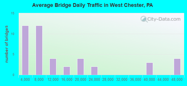
- 572,131Total average daily traffic
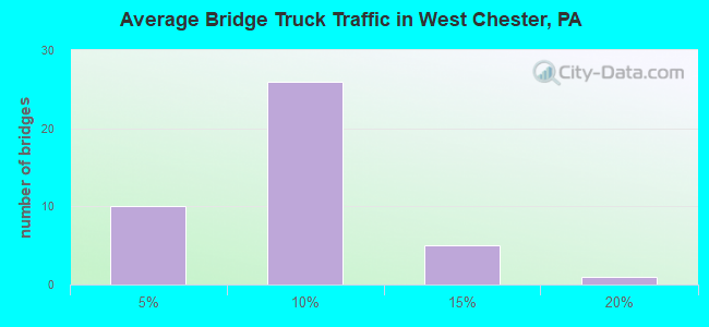
- 37,375Total average daily truck traffic
- National Bridge Inventory (NBI) Registered Bridges for West Chester
- No street view available for this location
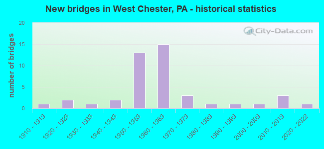
- New bridges - historical statistics
- 11910-1919
- 21920-1929
- 11930-1939
- 21940-1949
- 131950-1959
- 151960-1969
- 31970-1979
- 11980-1989
- 11990-1999
- 12000-2009
- 32010-2019
- 12020-2022
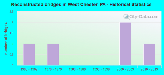
- Reconstructed bridges - Historical Statistics
- 11960-1969
- 11970-1979
- 01980-1989
- 01990-1999
- 22000-2009
- 12010-2019
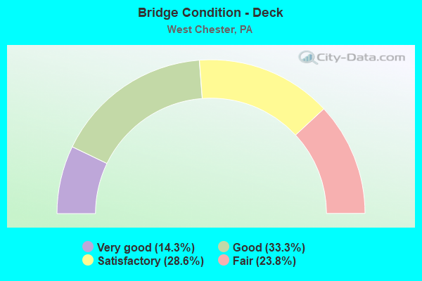
- Bridge Condition - Deck
- 14.3%Very good
- 33.3%Good
- 28.6%Satisfactory
- 23.8%Fair
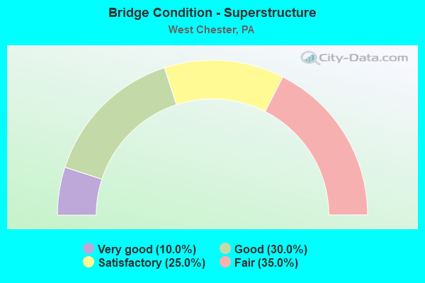
- Bridge Condition - Superstructure
- 10.0%Very good
- 30.0%Good
- 25.0%Satisfactory
- 35.0%Fair
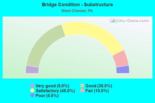
- Bridge Condition - Substructure
- 5.0%Very good
- 35.0%Good
- 45.0%Satisfactory
- 10.0%Fair
- 5.0%Poor
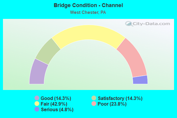
- Bridge Condition - Channel
- 14.3%Good
- 14.3%Satisfactory
- 42.9%Fair
- 23.8%Poor
- 4.8%Serious
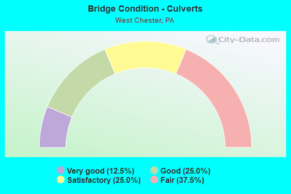
- Bridge Condition - Culverts
- 12.5%Very good
- 25.0%Good
- 25.0%Satisfactory
- 37.5%Fair
Find on map >> Show street view
Structure Number: 9922, Location: 5MI.TO LR-15090 32B10 (Lat: 39.962400, Lng: -75.600897), Route carried "on" structure: State highway 3, Year Built: 1960, Status: Open, Structure Length: 0.67m (2.20ft), Average Daily Traffic: 18,590 (year 2022), Truck Traffic: 4%, Average Future Daily Traffic: 18,452 (year 2032), Design Load: HS 20, Features Intersected: PENN CENTRAL (ABANDONED), Facility Carried by Structure: EAST GAY STREET
Minimum Vertical Clearance: 30+ m (98+ ft), Kilometerpoint: 0.753, Lanes on structure: 2, Base Highway Network: Yes, Owner: Railroad, Approaching Roadway Width: 12.2m (40.0ft), Skew: 2 degrees, Material/Design: Concrete, Design/Construction: Slab, Number Of Spans In Main Unit: 1, Length of Maximum Span: 6.4m (21.0ft), Curb or Sidewalk Widths: Left: 2.7m (8.9ft), Right: 2.7m (8.9ft), Curb-To-Curb Width: 12.2m (40.0ft), Out-to-Out Width: 18.4m (60.4ft)
Condition: Deck: Satisfactory, Superstructure: Satisfactory, Substructure: Satisfactory, Operating Rating: 44.5 metric tons, Method Used To Determine Operating Rating: Load Factor (LF), Inventory Rating: 26.3 metric tons, Method Used To Determine Inventory Rating: Load Factor (LF), Structural Evaluation: Equal to present minimum criteria, Deck Geometry: Better than present minimum criteria, Underclear: High priority of corrective action, Approach Roadway Alignment: Equal to present desirable criteria, Length Of Structure Improvement: 1.30m (4.27ft), Designated Inspection Frequency: Every 24 months, Inspection Date: August 2020, Deck Structure Type: Concrete Cast-file-Place, Wearing Surface/Protective System: Wearing Surface: Monolithic Concrete
Find on map >> Show street view
Structure Number: 10036, Location: .7 MI. S PRICE STR. 41A1 (Lat: 39.942861, Lng: -75.609850), Route carried "on" structure: State highway 52, Year Built: 1988, Status: Open, Structure Length: 0.98m (3.22ft), Average Daily Traffic: 7,105 (year 2022), Truck Traffic: 6%, Average Future Daily Traffic: 11,790 (year 2035), Design Load: HS 20, Features Intersected: BRANCH PLUM RUN, Facility Carried by Structure: LENAPE ROAD
Minimum Vertical Clearance: 30+ m (98+ ft), Kilometerpoint: 15.783, Lanes on structure: 5, Owner: State Highway Agency, Approaching Roadway Width: 18.6m (61.0ft), Skew: 4 degrees, Material/Design: Steel, Design/Construction: Culvert, Number Of Spans In Main Unit: 3, Length of Maximum Span: 2.7m (8.9ft)
Condition: Channel: Fair, Culverts: Fair, Operating Rating: 54.4 metric tons, Method Used To Determine Operating Rating: Field evaluation and documented engineering judgment, Inventory Rating: 32.7 metric tons, Method Used To Determine Inventory Rating: Field evaluation and documented engineering judgment, Structural Evaluation: Somewhat better than minimum adequacy, Waterway Adequacy: Equal to present minimum criteria, Approach Roadway Alignment: Equal to present desirable criteria, Length Of Structure Improvement: 1.60m (5.25ft), Designated Inspection Frequency: Every 24 months, Inspection Date: January 2020
Find on map >> Show street view
Structure Number: 10057, Location: LEANAPE 40H06 (Lat: 39.914331, Lng: -75.627656), Route carried "on" structure: State highway 100, Year Built: 1960, Status: Open, Structure Length: 0.94m (3.08ft), Average Daily Traffic: 1,055 (year 2021), Truck Traffic: 8%, Average Future Daily Traffic: 1,659 (year 2032), Design Load: HS 20, Features Intersected: PLUM CREEK, Facility Carried by Structure: CREEK ROAD
Minimum Vertical Clearance: 30+ m (98+ ft), Kilometerpoint: 6.465, Lanes on structure: 2, Owner: State Highway Agency, Approaching Roadway Width: 6.4m (21.0ft), Skew: 1 degrees, Material/Design: Prestressed concrete, Design/Construction: Box Beam or Girders - Multiple, Number Of Spans In Main Unit: 1, Length of Maximum Span: 8.8m (28.9ft), Curb-To-Curb Width: 7.8m (25.6ft), Out-to-Out Width: 8.3m (27.2ft)
Condition: Deck: Satisfactory, Superstructure: Fair, Substructure: Satisfactory, Channel: Fair, Operating Rating: 69.9 metric tons, Method Used To Determine Operating Rating: Load Factor (LF), Inventory Rating: 36.3 metric tons, Method Used To Determine Inventory Rating: Load Factor (LF), Structural Evaluation: Somewhat better than minimum adequacy, Deck Geometry: Meets minimum limits, Waterway Adequacy: Somewhat better than minimum adequacy, Approach Roadway Alignment: Equal to present desirable criteria, Length Of Structure Improvement: 1.60m (5.25ft), Designated Inspection Frequency: Every 24 months, Inspection Date: May 2020, Deck Structure Type: Other, Wearing Surface/Protective System: Wearing Surface: Bituminous
Find on map >> Show street view
Structure Number: 10058, Location: NEAR WEST CHESTER 31K8 (Lat: 39.973203, Lng: -75.614581), Route carried "on" structure: State highway 100, Year Built: 1955, Year Reconstructed: 2010, Status: Open, Structure Length: 2.35m (7.71ft), Average Daily Traffic: 16,134 (year 2022), Truck Traffic: 5%, Average Future Daily Traffic: 23,437 (year 2032), Design Load: HS 20, Features Intersected: W. CHESTER BYPASS (322), Facility Carried by Structure: POTTSTOWN PIKE
Minimum Vertical Clearance: 30+ m (98+ ft), Kilometerpoint: 9.407, Lanes on structure: 2, Lanes under structure: 4, Owner: State Highway Agency, Approaching Roadway Width: 20.4m (66.9ft), Skew: 20 degrees, Material/Design: Steel, Design/Construction: Stringer/Multi-beam, Number Of Spans In Main Unit: 1, Length of Maximum Span: 22.6m (74.1ft), Curb or Sidewalk Widths: Left: 1.8m (5.9ft), Right: 1.8m (5.9ft), Curb-To-Curb Width: 21.0m (68.9ft), Out-to-Out Width: 25.0m (82.0ft)
Condition: Deck: Fair, Superstructure: Satisfactory, Substructure: Satisfactory, Operating Rating: 80.7 metric tons, Method Used To Determine Operating Rating: Load Factor (LF), Inventory Rating: 48.1 metric tons, Method Used To Determine Inventory Rating: Load Factor (LF), Structural Evaluation: Equal to present minimum criteria, Deck Geometry: Superior to present desirable criteria, Underclear: Meets minimum limits, Approach Roadway Alignment: Equal to present desirable criteria, Length Of Structure Improvement: 3.00m (9.84ft), Designated Inspection Frequency: Every 24 months, Inspection Date: October 2020, Bridge Improvement Cost: $53,000, Roadway Improvement Cost: $157,000, Total Project Cost: $719,000, Deck Structure Type: Concrete Cast-file-Place, Wearing Surface/Protective System: Wearing Surface: Monolithic Concrete
Find on map >> Show street view
Structure Number: 10059, Location: NEAR WEST CHESTER 31K8 (Lat: 39.973419, Lng: -75.614706), Route carried "on" structure: State highway 100, Year Built: 1953, Status: Open, Structure Length: 0.67m (2.20ft), Average Daily Traffic: 16,134 (year 2022), Truck Traffic: 5%, Average Future Daily Traffic: 23,437 (year 2035), Design Load: HS 20, Features Intersected: TAYLOR RUN, Facility Carried by Structure: POTTSTOWN PIKE
Minimum Vertical Clearance: 30+ m (98+ ft), Kilometerpoint: 9.407, Lanes on structure: 4, Owner: State Highway Agency, Approaching Roadway Width: 16.2m (53.1ft), Skew: 20 degrees, Material/Design: Concrete, Design/Construction: Culvert, Number Of Spans In Main Unit: 1, Length of Maximum Span: 6.7m (22.0ft)
Condition: Channel: Fair, Culverts: Satisfactory, Operating Rating: 78.0 metric tons, Method Used To Determine Operating Rating: Field evaluation and documented engineering judgment, Inventory Rating: 46.3 metric tons, Method Used To Determine Inventory Rating: Field evaluation and documented engineering judgment, Structural Evaluation: Equal to present minimum criteria, Waterway Adequacy: Superior to present desirable criteria, Approach Roadway Alignment: Equal to present desirable criteria, Length Of Structure Improvement: 1.50m (4.92ft), Designated Inspection Frequency: Every 24 months, Inspection Date: January 2020
Find on map >> Show street view
Structure Number: 10087, Location: 1MI.COUNTY LINE 31F10 (Lat: 39.960394, Lng: -75.638867), Route carried "on" structure: State highway 162, Year Built: 1969, Status: Open, Structure Length: 1.13m (3.71ft), Average Daily Traffic: 4,614 (year 2020), Truck Traffic: 4%, Average Future Daily Traffic: 7,373 (year 2032), Design Load: HS 20, Features Intersected: TAYLORS RUN, Facility Carried by Structure: STRASBURG ROAD
Minimum Vertical Clearance: 30+ m (98+ ft), Kilometerpoint: 14.304, Lanes on structure: 2, Owner: State Highway Agency, Approaching Roadway Width: 13.7m (44.9ft), Material/Design: Prestressed concrete, Design/Construction: Box Beam or Girders - Single/Spread, Number Of Spans In Main Unit: 1, Length of Maximum Span: 11.0m (36.1ft), Curb or Sidewalk Widths: Left: 0.2m (0.7ft), Right: 0.2m (0.7ft), Curb-To-Curb Width: 13.4m (44.0ft), Out-to-Out Width: 14.6m (47.9ft)
Condition: Deck: Good, Superstructure: Good, Substructure: Satisfactory, Channel: Satisfactory, Operating Rating: 53.5 metric tons, Method Used To Determine Operating Rating: Load Factor (LF), Inventory Rating: 29.9 metric tons, Method Used To Determine Inventory Rating: Load Factor (LF), Structural Evaluation: Equal to present minimum criteria, Deck Geometry: Better than present minimum criteria, Waterway Adequacy: Equal to present minimum criteria, Approach Roadway Alignment: Equal to present desirable criteria, Length Of Structure Improvement: 1.70m (5.58ft), Designated Inspection Frequency: Every 24 months, Inspection Date: August 2020, Deck Structure Type: Concrete Cast-file-Place, Wearing Surface/Protective System: Wearing Surface: Bituminous
Find on map >> Show street view
Structure Number: 10089, Location: SOUTH WEST CHESTER 41C1 (Lat: 39.940275, Lng: -75.590728), Route carried "on" structure: US 202, Year Built: 1953, Year Reconstructed: 2009, Status: Open, Structure Length: 2.80m (9.19ft), Average Daily Traffic: 46,231 (year 2022), Truck Traffic: 5%, Average Future Daily Traffic: 53,850 (year 2032), Design Load: HS 20, Features Intersected: HIGH STREET, Facility Carried by Structure: WEST CHESTER BYPAS
Minimum Vertical Clearance: 30+ m (98+ ft), Kilometerpoint: 4.971, Lanes on structure: 2, Lanes under structure: 4, Base Highway Network: Yes, Owner: State Highway Agency, Approaching Roadway Width: 17.1m (56.1ft), Skew: 33 degrees, Material/Design: Steel, Design/Construction: Stringer/Multi-beam, Number Of Spans In Main Unit: 1, Length of Maximum Span: 26.8m (87.9ft), Curb-To-Curb Width: 16.3m (53.5ft), Out-to-Out Width: 18.3m (60.0ft)
Condition: Deck: Satisfactory, Superstructure: Fair, Substructure: Good, Operating Rating: 74.4 metric tons, Method Used To Determine Operating Rating: Load Factor (LF), Inventory Rating: 44.5 metric tons, Method Used To Determine Inventory Rating: Load Factor (LF), Structural Evaluation: Somewhat better than minimum adequacy, Deck Geometry: Superior to present desirable criteria, Underclear: High priority of corrective action, Approach Roadway Alignment: Better than present minimum criteria, Length Of Structure Improvement: 3.40m (11.15ft), Designated Inspection Frequency: Every 24 months, Inspection Date: October 2020, Bridge Improvement Cost: $65,000, Roadway Improvement Cost: $192,000, Total Project Cost: $879,000, Deck Structure Type: Concrete Cast-file-Place, Wearing Surface/Protective System: Wearing Surface: Bituminous
Find on map >> Show street view
Structure Number: 10091, Location: NEAR WEST CHESTER 32E12 (Lat: 39.949661, Lng: -75.582317), Route carried "on" structure: US 202, Year Built: 1954, Year Reconstructed: 1967, Status: Open, Structure Length: 0.70m (2.30ft), Average Daily Traffic: 46,231 (year 2022), Truck Traffic: 5%, Average Future Daily Traffic: 53,850 (year 2035), Design Load: HS 20, Features Intersected: BRANCH CHESTER CREEK, Facility Carried by Structure: WEST CHESTER BYPAS
Minimum Vertical Clearance: 30+ m (98+ ft), Kilometerpoint: 5.734, Lanes on structure: 4, Base Highway Network: Yes, Owner: State Highway Agency, Approaching Roadway Width: 20.7m (67.9ft), Skew: 33 degrees, Material/Design: Concrete, Design/Construction: Culvert, Number Of Spans In Main Unit: 1, Length of Maximum Span: 7.0m (23.0ft)
Condition: Channel: Fair, Culverts: Fair, Operating Rating: 89.8 metric tons, Method Used To Determine Operating Rating: Field evaluation and documented engineering judgment, Inventory Rating: 32.7 metric tons, Method Used To Determine Inventory Rating: Field evaluation and documented engineering judgment, Structural Evaluation: Somewhat better than minimum adequacy, Waterway Adequacy: Superior to present desirable criteria, Approach Roadway Alignment: Equal to present desirable criteria, Length Of Structure Improvement: 1.60m (5.25ft), Designated Inspection Frequency: Every 24 months, Inspection Date: January 2020
Find on map >> Show street view
Structure Number: 10093, Location: NEAR WEST CHESTER 32E12 (Lat: 39.951861, Lng: -75.581558), Route carried "on" structure: US 202, Year Built: 1954, Status: Open, Structure Length: 1.07m (3.51ft), Average Daily Traffic: 46,231 (year 2022), Truck Traffic: 5%, Average Future Daily Traffic: 53,850 (year 2032), Design Load: HS 20, Features Intersected: BOLMAR STREET(T349), Facility Carried by Structure: WEST CHESTER BYPAS
Minimum Vertical Clearance: 30+ m (98+ ft), Kilometerpoint: 6.412, Lanes on structure: 2, Lanes under structure: 2, Base Highway Network: Yes, Owner: State Highway Agency, Approaching Roadway Width: 21.3m (69.9ft), Skew: 31 degrees, Material/Design: Concrete, Design/Construction: Tee Beam, Number Of Spans In Main Unit: 1, Length of Maximum Span: 10.4m (34.1ft), Curb-To-Curb Width: 19.5m (64.0ft), Out-to-Out Width: 21.6m (70.9ft)
Condition: Deck: Good, Superstructure: Satisfactory, Substructure: Good, Operating Rating: 68.9 metric tons, Method Used To Determine Operating Rating: Load Factor (LF), Inventory Rating: 41.7 metric tons, Method Used To Determine Inventory Rating: Load Factor (LF), Structural Evaluation: Equal to present minimum criteria, Deck Geometry: Superior to present desirable criteria, Underclear: High priority of corrective action, Approach Roadway Alignment: Equal to present desirable criteria, Length Of Structure Improvement: 1.60m (5.25ft), Designated Inspection Frequency: Every 24 months, Inspection Date: July 2020, Bridge Improvement Cost: $9,000, Roadway Improvement Cost: $25,000, Total Project Cost: $116,000, Deck Structure Type: Concrete Cast-file-Place, Wearing Surface/Protective System: Wearing Surface: Bituminous
Find on map >> Show street view
Structure Number: 10103, Location: WEST CHESTER 32D07 (Lat: 39.980772, Lng: -75.588289), Route carried "on" structure: US 202, Year Built: 1968, Status: Open, Structure Length: 1.37m (4.49ft), Average Daily Traffic: 36,343 (year 2021), Truck Traffic: 6%, Average Future Daily Traffic: 41,918 (year 2032), Design Load: HS 20, Features Intersected: WEST CHESTER BYPASS WB
Minimum Vertical Clearance: 30+ m (98+ ft), Kilometerpoint: 9.872, Lanes on structure: 2, Lanes under structure: 1, Base Highway Network: Yes, Owner: State Highway Agency, Approaching Roadway Width: 12.2m (40.0ft), Skew: 13 degrees, Material/Design: Prestressed concrete, Design/Construction: Stringer/Multi-beam, Number Of Spans In Main Unit: 1, Length of Maximum Span: 13.4m (44.0ft), Curb or Sidewalk Widths: Left: 0.2m (0.7ft), Right: 0.2m (0.7ft), Curb-To-Curb Width: 12.2m (40.0ft), Out-to-Out Width: 13.4m (44.0ft)
Condition: Deck: Good, Superstructure: Good, Substructure: Good, Operating Rating: 71.7 metric tons, Method Used To Determine Operating Rating: Load Factor (LF), Inventory Rating: 32.7 metric tons, Method Used To Determine Inventory Rating: Load Factor (LF), Structural Evaluation: Better than present minimum criteria, Deck Geometry: Better than present minimum criteria, Underclear: Equal to present minimum criteria, Approach Roadway Alignment: Equal to present desirable criteria, Length Of Structure Improvement: 2.10m (6.89ft), Designated Inspection Frequency: Every 24 months, Inspection Date: June 2020, Deck Structure Type: Concrete Cast-file-Place, Wearing Surface/Protective System: Wearing Surface: Bituminous
Find on map >> Show street view
Structure Number: 10265, Location: SHAWS BRIDGE 40E04 (Lat: 39.925244, Lng: -75.648506), Route carried "on" structure: State highway 842, Year Built: 1952, Status: Open, Structure Length: 7.99m (26.21ft), Average Daily Traffic: 4,494 (year 2022), Truck Traffic: 9%, Average Future Daily Traffic: 3,552 (year 2032), Design Load: HS 20, Features Intersected: E.BR.BRANDYWINE CREEK, Facility Carried by Structure: BRIDGE ROAD
Minimum Vertical Clearance: 30+ m (98+ ft), Kilometerpoint: 17.737, Lanes on structure: 2, Owner: State Highway Agency, Approaching Roadway Width: 8.8m (28.9ft), Material/Design: Steel continuous, Design/Construction: Stringer/Multi-beam, Number Of Spans In Main Unit: 4, Length of Maximum Span: 21.9m (71.9ft), Curb or Sidewalk Widths: Left: 1.4m (4.6ft), Right: 0.6m (2.0ft), Curb-To-Curb Width: 7.3m (24.0ft), Out-to-Out Width: 9.8m (32.2ft)
Condition: Deck: Fair, Superstructure: Fair, Substructure: Satisfactory, Channel: Fair, Operating Rating: 88.0 metric tons, Method Used To Determine Operating Rating: Load Factor (LF), Inventory Rating: 52.6 metric tons, Method Used To Determine Inventory Rating: Load Factor (LF), Structural Evaluation: Somewhat better than minimum adequacy, Deck Geometry: High priority of replacement, Waterway Adequacy: Better than present minimum criteria, Approach Roadway Alignment: Equal to present desirable criteria, Length Of Structure Improvement: 8.80m (28.87ft), Designated Inspection Frequency: Every 24 months, Inspection Date: August 2020, Deck Structure Type: Concrete Cast-file-Place, Wearing Surface/Protective System: Wearing Surface: Monolithic Concrete
Find on map >> Show street view
Structure Number: 10282, Location: .3MI.W.ROUTE 100 40G09 (Lat: 39.897311, Lng: -75.632292), Route carried "on" structure: State highway 926, Year Built: 1937, Year Reconstructed: 2000, Status: Open, Structure Length: 1.46m (4.79ft), Average Daily Traffic: 7,070 (year 2020), Truck Traffic: 9%, Average Future Daily Traffic: 12,502 (year 2032), Design Load: HS 20, Features Intersected: POCOPSON CREEK, Facility Carried by Structure: STREET ROAD
Minimum Vertical Clearance: 30+ m (98+ ft), Kilometerpoint: 27.388, Lanes on structure: 2, Owner: State Highway Agency, Approaching Roadway Width: 7.3m (24.0ft), Material/Design: Steel, Design/Construction: Stringer/Multi-beam, Number Of Spans In Main Unit: 1, Length of Maximum Span: 14.0m (45.9ft), Curb or Sidewalk Widths: Left: 0.2m (0.7ft), Right: 0.2m (0.7ft), Curb-To-Curb Width: 7.3m (24.0ft), Out-to-Out Width: 8.4m (27.6ft)
Condition: Deck: Very good, Superstructure: Fair, Substructure: Poor, Channel: Poor, Operating Rating: 56.2 metric tons, Method Used To Determine Operating Rating: Load Factor (LF), Inventory Rating: 33.6 metric tons, Method Used To Determine Inventory Rating: Load Factor (LF), Structural Evaluation: Meets minimum limits, Deck Geometry: High priority of replacement, Waterway Adequacy: Equal to present minimum criteria, Approach Roadway Alignment: Equal to present desirable criteria, Length Of Structure Improvement: 2.10m (6.89ft), Designated Inspection Frequency: Every 24 months, Underwater Inspection Frequency: Every 24 months, Inspection Date: August 2020, Underwater Inspection Date: October 2020, Bridge Improvement Cost: $15,000, Roadway Improvement Cost: $43,000, Total Project Cost: $198,000, Deck Structure Type: Concrete Cast-file-Place, Wearing Surface/Protective System: Wearing Surface: Monolithic Concrete
Find on map >> Show street view
Structure Number: 10388, Location: 2MI.N.WEST CHESTER 32C04 (Lat: 39.996253, Lng: -75.594133), Route carried "on" structure: State highway , Year Built: 1968, Status: Open, Structure Length: 3.38m (11.09ft), Average Daily Traffic: 13,609 (year 2022), Truck Traffic: 5%, Average Future Daily Traffic: 15,701 (year 2032), Design Load: HS 20, Features Intersected: PA 100 BYPASS, Facility Carried by Structure: PHOENIXVILLE PIKE
Minimum Vertical Clearance: 30+ m (98+ ft), Kilometerpoint: 4.141, Lanes on structure: 2, Lanes under structure: 4, Owner: State Highway Agency, Approaching Roadway Width: 13.4m (44.0ft), Skew: 3 degrees, Material/Design: Steel, Design/Construction: Stringer/Multi-beam, Number Of Spans In Main Unit: 1, Length of Maximum Span: 32.0m (105.0ft), Curb or Sidewalk Widths: Left: 0.2m (0.7ft), Right: 0.2m (0.7ft), Curb-To-Curb Width: 11.6m (38.1ft), Out-to-Out Width: 13.4m (44.0ft)
Condition: Deck: Satisfactory, Superstructure: Satisfactory, Substructure: Good, Operating Rating: 79.8 metric tons, Method Used To Determine Operating Rating: Load Factor (LF), Inventory Rating: 48.1 metric tons, Method Used To Determine Inventory Rating: Load Factor (LF), Structural Evaluation: Equal to present minimum criteria, Deck Geometry: Somewhat better than minimum adequacy, Underclear: High priority of corrective action, Approach Roadway Alignment: Better than present minimum criteria, Length Of Structure Improvement: 4.20m (13.78ft), Designated Inspection Frequency: Every 24 months, Inspection Date: May 2020, Deck Structure Type: Concrete Cast-file-Place, Wearing Surface/Protective System: Wearing Surface: Bituminous
Find on map >> Show street view
Structure Number: 10393, Location: NR.WEST CHESTER 32H06 (Lat: 39.984228, Lng: -75.562303), Route carried "on" structure: State highway , Year Built: 1946, Status: Open, Structure Length: 0.98m (3.22ft), Average Daily Traffic: 11,023 (year 2021), Truck Traffic: 5%, Average Future Daily Traffic: 17,344 (year 2032), Design Load: HS 20, Features Intersected: CHESTER CREEK, Facility Carried by Structure: PAOLI PIKE
Minimum Vertical Clearance: 30+ m (98+ ft), Kilometerpoint: 3.330, Lanes on structure: 2, Owner: State Highway Agency, Approaching Roadway Width: 9.8m (32.2ft), Material/Design: Concrete, Design/Construction: Tee Beam, Number Of Spans In Main Unit: 1, Length of Maximum Span: 9.4m (30.8ft), Curb-To-Curb Width: 9.8m (32.2ft), Out-to-Out Width: 10.7m (35.1ft)
Condition: Deck: Fair, Superstructure: Fair, Substructure: Fair, Channel: Poor, Operating Rating: 61.7 metric tons, Method Used To Determine Operating Rating: Load Factor (LF), Inventory Rating: 37.2 metric tons, Method Used To Determine Inventory Rating: Load Factor (LF), Structural Evaluation: Somewhat better than minimum adequacy, Deck Geometry: Meets minimum limits, Waterway Adequacy: Equal to present minimum criteria, Approach Roadway Alignment: Equal to present desirable criteria, Length Of Structure Improvement: 1.60m (5.25ft), Designated Inspection Frequency: Every 24 months, Inspection Date: July 2020, Bridge Improvement Cost: $8,000, Roadway Improvement Cost: $24,000, Total Project Cost: $110,000, Deck Structure Type: Concrete Cast-file-Place, Wearing Surface/Protective System: Wearing Surface: Bituminous
Find on map >> Show street view
Structure Number: 10456, Location: 1 MI. S OF SR 926 40H9 (Lat: 39.896922, Lng: -75.624086), Route carried "on" structure: State highway , Year Built: 1929, Status: Open, Structure Length: 0.98m (3.22ft), Average Daily Traffic: 1,209 (year 2022), Truck Traffic: 3%, Average Future Daily Traffic: 2,287 (year 2032), Design Load: H 15, Features Intersected: POCOPSON CREEK, Facility Carried by Structure: POCOPSON ROAD
Minimum Vertical Clearance: 30+ m (98+ ft), Kilometerpoint: 1.963, Lanes on structure: 2, Owner: State Highway Agency, Approaching Roadway Width: 5.2m (17.1ft), Skew: 2 degrees, Material/Design: Steel, Design/Construction: Stringer/Multi-beam, Number Of Spans In Main Unit: 1, Length of Maximum Span: 9.1m (29.9ft), Curb-To-Curb Width: 5.3m (17.4ft), Out-to-Out Width: 6.1m (20.0ft)
Condition: Deck: Satisfactory, Superstructure: Fair, Substructure: Satisfactory, Channel: Poor, Operating Rating: 80.7 metric tons, Method Used To Determine Operating Rating: Load Factor (LF), Inventory Rating: 48.1 metric tons, Method Used To Determine Inventory Rating: Load Factor (LF), Structural Evaluation: Somewhat better than minimum adequacy, Deck Geometry: High priority of replacement, Waterway Adequacy: Equal to present minimum criteria, Approach Roadway Alignment: Equal to present minimum criteria, Length Of Structure Improvement: 1.00m (3.28ft), Designated Inspection Frequency: Every 24 months, Inspection Date: April 2020, Bridge Improvement Cost: $3,000, Roadway Improvement Cost: $9,000, Total Project Cost: $42,000, Deck Structure Type: Concrete Cast-file-Place, Wearing Surface/Protective System: Wearing Surface: Bituminous
Find on map >> Show street view
Structure Number: 10542, Location: EAST BRADFORD TWP. 31E6 (Lat: 39.985206, Lng: -75.646558), Route carried "on" structure: State highway , Year Built: 1975, Status: Open, Structure Length: 1.01m (3.31ft), Average Daily Traffic: 1,868 (year 2022), Truck Traffic: 6%, Average Future Daily Traffic: 2,115 (year 2032), Design Load: HS 20, Features Intersected: BROAD RUN, Facility Carried by Structure: COPELAND SCHOOL RD
Minimum Vertical Clearance: 30+ m (98+ ft), Kilometerpoint: 0.000, Lanes on structure: 2, Owner: State Highway Agency, Approaching Roadway Width: 12.8m (42.0ft), Material/Design: Prestressed concrete, Design/Construction: Slab, Number Of Spans In Main Unit: 1, Length of Maximum Span: 9.8m (32.2ft), Curb or Sidewalk Widths: Left: 0.2m (0.7ft), Right: 0.2m (0.7ft), Curb-To-Curb Width: 12.8m (42.0ft), Out-to-Out Width: 13.9m (45.6ft)
Condition: Deck: Satisfactory, Superstructure: Good, Substructure: Good, Channel: Fair, Operating Rating: 93.4 metric tons, Method Used To Determine Operating Rating: Load Factor (LF), Inventory Rating: 46.3 metric tons, Method Used To Determine Inventory Rating: Load Factor (LF), Structural Evaluation: Better than present minimum criteria, Deck Geometry: Better than present minimum criteria, Waterway Adequacy: Better than present minimum criteria, Approach Roadway Alignment: Better than present minimum criteria, Length Of Structure Improvement: 1.60m (5.25ft), Designated Inspection Frequency: Every 24 months, Inspection Date: July 2020, Deck Structure Type: Concrete Cast-file-Place, Wearing Surface/Protective System: Wearing Surface: Monolithic Concrete, Deck Protection: Galvanized Reinforcing
Find on map >> Show street view
Structure Number: 1056, Location: N.WEST CHESTER 31G09 (Lat: 39.965922, Lng: -75.631872), Route carried "on" structure: US 322B, Year Built: 1928, Year Reconstructed: 1979, Status: Open, Structure Length: 0.82m (2.69ft), Average Daily Traffic: 6,910 (year 2020), Truck Traffic: 8%, Average Future Daily Traffic: 13,118 (year 2032), Design Load: HS 25 or greater, Features Intersected: TAYLORS RUN, Facility Carried by Structure: DOWNINGTOWN PIKE
Minimum Vertical Clearance: 30+ m (98+ ft), Kilometerpoint: 0.000, Lanes on structure: 4, Base Highway Network: Yes, Owner: State Highway Agency, Approaching Roadway Width: 23.5m (77.1ft), Skew: 3 degrees, Material/Design: Concrete, Design/Construction: Tee Beam, Number Of Spans In Main Unit: 1, Length of Maximum Span: 7.9m (25.9ft), Curb-To-Curb Width: 23.5m (77.1ft), Out-to-Out Width: 24.3m (79.7ft)
Condition: Deck: Fair, Superstructure: Fair, Substructure: Fair, Channel: Poor, Operating Rating: 49.0 metric tons, Method Used To Determine Operating Rating: Load Factor (LF), Inventory Rating: 29.0 metric tons, Method Used To Determine Inventory Rating: Load Factor (LF), Structural Evaluation: Somewhat better than minimum adequacy, Deck Geometry: Superior to present desirable criteria, Waterway Adequacy: Equal to present minimum criteria, Approach Roadway Alignment: Equal to present desirable criteria, Length Of Structure Improvement: 1.40m (4.59ft), Designated Inspection Frequency: Every 24 months, Inspection Date: August 2020, Bridge Improvement Cost: $8,000, Roadway Improvement Cost: $23,000, Total Project Cost: $106,000, Deck Structure Type: Concrete Cast-file-Place, Wearing Surface/Protective System: Wearing Surface: Monolithic Concrete, Deck Protection: Epoxy Coated Reinforcing
Find on map >> Show street view
Structure Number: 10782, Location: E GOSHEN TWP ADC 3583-K4 (Lat: 39.979039, Lng: -75.563044), Route carried "on" structure: City street , Year Built: 1974, Status: Open, Structure Length: 0.91m (2.99ft), Average Daily Traffic: 4,350 (year 1989), Truck Traffic: 3%, Average Future Daily Traffic: 6,090 (year 2009), Design Load: HS 20, Features Intersected: TRIBUTARY OF CHESTER CRE, Facility Carried by Structure: ELLIS LANE
Minimum Vertical Clearance: 30+ m (98+ ft), Kilometerpoint: 0.000, Lanes on structure: 2, Owner: Town or Township Highway Agency, Approaching Roadway Width: 6.1m (20.0ft), Material/Design: Concrete continuous, Design/Construction: Slab, Number Of Spans In Main Unit: 2, Length of Maximum Span: 4.6m (15.1ft), Curb or Sidewalk Widths: Left: 1.1m (3.6ft), Right: 1.1m (3.6ft), Curb-To-Curb Width: 7.3m (24.0ft), Out-to-Out Width: 10.1m (33.1ft)
Condition: Deck: Good, Superstructure: Good, Substructure: Good, Channel: Fair, Operating Rating: 71.7 metric tons, Method Used To Determine Operating Rating: Field evaluation and documented engineering judgment, Inventory Rating: 42.6 metric tons, Method Used To Determine Inventory Rating: Field evaluation and documented engineering judgment, Structural Evaluation: Better than present minimum criteria, Deck Geometry: High priority of replacement, Waterway Adequacy: Better than present minimum criteria, Approach Roadway Alignment: Equal to present desirable criteria, Length Of Structure Improvement: 1.60m (5.25ft), Designated Inspection Frequency: Every 24 months, Inspection Date: April 2020, Deck Structure Type: Concrete Cast-file-Place, Wearing Surface/Protective System: Wearing Surface: Bituminous
Find on map >> Show street view
Structure Number: 10783, Location: 0.9 MI NW OF SR3 3584-B4 (Lat: 39.976628, Lng: -75.551592), Route carried "on" structure: City street , Year Built: 1977, Status: Open, Structure Length: 1.07m (3.51ft), Average Daily Traffic: 220 (year 1989), Truck Traffic: 2%, Average Future Daily Traffic: 308 (year 2015), Design Load: HS 20, Features Intersected: CHESTER CREEK TRIBUTARY, Facility Carried by Structure: BALDWIN DRIVE
Minimum Vertical Clearance: 30+ m (98+ ft), Kilometerpoint: 0.000, Lanes on structure: 2, Owner: Town or Township Highway Agency, Approaching Roadway Width: 8.8m (28.9ft), Material/Design: Prestressed concrete, Design/Construction: Box Beam or Girders - Multiple, Number Of Spans In Main Unit: 1, Length of Maximum Span: 10.4m (34.1ft), Curb-To-Curb Width: 9.2m (30.2ft), Out-to-Out Width: 9.8m (32.2ft)
Condition: Deck: Fair, Superstructure: Satisfactory, Substructure: Satisfactory, Channel: Fair, Operating Rating: 72.6 metric tons, Method Used To Determine Operating Rating: Field evaluation and documented engineering judgment, Inventory Rating: 43.5 metric tons, Method Used To Determine Inventory Rating: Field evaluation and documented engineering judgment, Structural Evaluation: Equal to present minimum criteria, Deck Geometry: Equal to present minimum criteria, Waterway Adequacy: Better than present minimum criteria, Approach Roadway Alignment: Equal to present desirable criteria, Length Of Structure Improvement: 1.30m (4.27ft), Designated Inspection Frequency: Every 24 months, Inspection Date: August 2019, Bridge Improvement Cost: $8,000, Roadway Improvement Cost: $25,000, Total Project Cost: $113,000, Deck Structure Type: Concrete Cast-file-Place, Wearing Surface/Protective System: Wearing Surface: Monolithic Concrete
Find on map >> Show street view
Structure Number: 10846, Location: At WC Reservoir 3583-J3 (Lat: 39.985181, Lng: -75.570950), Route carried "on" structure: City street , Year Built: 1965, Status: Open, Structure Length: 0.85m (2.79ft), Average Daily Traffic: 7,040 (year 2015), Truck Traffic: 1%, Average Future Daily Traffic: 8,000 (year 2035), Features Intersected: EAST BR CHESTER CREEK, Facility Carried by Structure: AIRPORT ROAD
Minimum Vertical Clearance: 30+ m (98+ ft), Kilometerpoint: 0.000, Lanes on structure: 2, Owner: Town or Township Highway Agency, Approaching Roadway Width: 7.6m (24.9ft), Skew: 4 degrees, Material/Design: Concrete, Design/Construction: Culvert, Number Of Spans In Main Unit: 2, Length of Maximum Span: 4.0m (13.1ft), Curb-To-Curb Width: 10.5m (34.4ft), Out-to-Out Width: 11.1m (36.4ft)
Condition: Channel: Good, Culverts: Satisfactory, Operating Rating: 48.1 metric tons, Method Used To Determine Operating Rating: Load Factor (LF), Inventory Rating: 29.0 metric tons, Method Used To Determine Inventory Rating: Load Factor (LF), Structural Evaluation: Equal to present minimum criteria, Deck Geometry: Meets minimum limits, Waterway Adequacy: Better than present minimum criteria, Approach Roadway Alignment: Equal to present desirable criteria, Length Of Structure Improvement: 1.50m (4.92ft), Designated Inspection Frequency: Every 24 months, Inspection Date: May 2020
Find on map >> Show street view
Structure Number: 10875, Location: US 322 INTERCH. 31K8 (Lat: 39.973831, Lng: -75.614700), Route carried "on" structure: Ramp State highway , Year Built: 1955, Status: Open, Structure Length: 0.67m (2.20ft), Average Daily Traffic: 1,360 (year 2022), Truck Traffic: 7%, Average Future Daily Traffic: 1,512 (year 2035), Design Load: HS 20, Features Intersected: TAYLOR RUN, Facility Carried by Structure: ON-RAMP TO SR 3100
Minimum Vertical Clearance: 30+ m (98+ ft), Kilometerpoint: 0.000, Lanes on structure: 1, Base Highway Network: Yes, Owner: State Highway Agency, Approaching Roadway Width: 6.1m (20.0ft), Skew: 2 degrees, Material/Design: Concrete, Design/Construction: Culvert, Number Of Spans In Main Unit: 1, Length of Maximum Span: 6.7m (22.0ft)
Condition: Channel: Serious, Culverts: Fair, Operating Rating: 96.2 metric tons, Method Used To Determine Operating Rating: Load Factor (LF), Inventory Rating: 57.2 metric tons, Method Used To Determine Inventory Rating: Load Factor (LF), Structural Evaluation: Somewhat better than minimum adequacy, Waterway Adequacy: Superior to present desirable criteria, Approach Roadway Alignment: Equal to present desirable criteria, Length Of Structure Improvement: 1.40m (4.59ft), Designated Inspection Frequency: Every 24 months, Other Special Inspection Frequency: Every 12 months, Inspection Date: January 2020, Other Special Inspection Date: January 2021
Find on map >> Show street view
Structure Number: 46069, Location: NEAR WEST CHESTER 32E12 (Lat: 39.951044, Lng: -75.581764), Route carried "on" structure: US 202, Year Built: 2011, Status: Open, Structure Length: 2.07m (6.79ft), Average Daily Traffic: 46,231 (year 2022), Truck Traffic: 5%, Average Future Daily Traffic: 53,850 (year 2032), Design Load: HL 93, Features Intersected: WEST CHESTER RR (SEPTA), Facility Carried by Structure: WEST CHESTER BYPAS
Minimum Vertical Clearance: 30+ m (98+ ft), Kilometerpoint: 6.412, Lanes on structure: 2, Base Highway Network: Yes, Owner: State Highway Agency, Approaching Roadway Width: 21.9m (71.9ft), Skew: 33 degrees, Material/Design: Prestressed concrete, Design/Construction: Box Beam or Girders - Single/Spread, Number Of Spans In Main Unit: 1, Length of Maximum Span: 20.7m (67.9ft), Curb or Sidewalk Widths: Left: 0.1m (0.3ft), Right: 0.1m (0.3ft), Curb-To-Curb Width: 21.9m (71.9ft), Out-to-Out Width: 24.6m (80.7ft)
Condition: Deck: Good, Superstructure: Very good, Substructure: Good, Operating Rating: 54.8 metric tons, Method Used To Determine Operating Rating: Assigned ratings based on Load and Resistance Factor Design (LRFD) reported by rating factor (RF) using HL93 loadings, Inventory Rating: 34.3 metric tons, Method Used To Determine Inventory Rating: Assigned ratings based on Load and Resistance Factor Design (LRFD) reported by rating factor (RF) using HL93 loadings, Structural Evaluation: Better than present minimum criteria, Deck Geometry: Superior to present desirable criteria, Underclear: High priority of corrective action, Approach Roadway Alignment: Equal to present desirable criteria, Designated Inspection Frequency: Every 24 months, Inspection Date: December 2020, Deck Structure Type: Concrete Cast-file-Place, Wearing Surface/Protective System: Wearing Surface: Monolithic Concrete, Membrane: Other, Deck Protection: Epoxy Coated Reinforcing
Find on map >> Show street view
Structure Number: 47164, Location: 0.6 Mi. E US-202 3583-J8 (Lat: 39.952131, Lng: -75.571697), Route carried "on" structure: Other road , Year Built: 2008, Status: Open, Structure Length: 2.38m (7.81ft), Average Daily Traffic: 100 (year 2012), Truck Traffic: 2%, Average Future Daily Traffic: 100 (year 2022), Design Load: HS 25 or greater, Features Intersected: TRIB. TO CHESTER CREEK, Facility Carried by Structure: COLD SPRINGS DRIVE
Minimum Vertical Clearance: 30+ m (98+ ft), Kilometerpoint: 0.000, Lanes on structure: 2, Owner: Town or Township Highway Agency, Approaching Roadway Width: 9.8m (32.2ft), Material/Design: Concrete, Design/Construction: Culvert, Number Of Spans In Main Unit: 3, Length of Maximum Span: 9.8m (32.2ft)
Condition: Channel: Good, Culverts: Good, Operating Rating: 59.0 metric tons, Method Used To Determine Operating Rating: Load Factor (LF), Inventory Rating: 36.3 metric tons, Method Used To Determine Inventory Rating: Load Factor (LF), Structural Evaluation: Better than present minimum criteria, Waterway Adequacy: Superior to present desirable criteria, Approach Roadway Alignment: Equal to present desirable criteria, Designated Inspection Frequency: Every 24 months, Inspection Date: June 2020
Find on map >> Show street view
Structure Number: 54189, Location: S of Ward Ave. 3583-F2 (Lat: 39.988178, Lng: -75.588639), Route carried "on" structure: Other road , Year Built: 1990, Status: Open, Structure Length: 0.61m (2.00ft), Average Daily Traffic: 800 (year 2017), Truck Traffic: 3%, Average Future Daily Traffic: 1,663 (year 2032), Design Load: HS 20, Features Intersected: E Br of Chester Creek, Facility Carried by Structure: N Five Points Road
Minimum Vertical Clearance: 30+ m (98+ ft), Kilometerpoint: 0.000, Lanes on structure: 2, Owner: Town or Township Highway Agency, Approaching Roadway Width: 7.9m (25.9ft), Skew: 4 degrees, Material/Design: Concrete, Design/Construction: Slab, Number Of Spans In Main Unit: 1, Length of Maximum Span: 6.1m (20.0ft), Curb-To-Curb Width: 8.1m (26.6ft), Out-to-Out Width: 9.8m (32.2ft)
Condition: Deck: Good, Superstructure: Good, Substructure: Satisfactory, Channel: Satisfactory, Operating Rating: 81.6 metric tons, Method Used To Determine Operating Rating: Field evaluation and documented engineering judgment, Inventory Rating: 49.0 metric tons, Method Used To Determine Inventory Rating: Field evaluation and documented engineering judgment, Structural Evaluation: Equal to present minimum criteria, Deck Geometry: Somewhat better than minimum adequacy, Waterway Adequacy: Better than present minimum criteria, Approach Roadway Alignment: Better than present minimum criteria, Designated Inspection Frequency: Every 24 months, Inspection Date: May 2021, Deck Structure Type: Concrete Cast-file-Place, Wearing Surface/Protective System: Wearing Surface: Bituminous, Deck Protection: Epoxy Coated Reinforcing
Find on map >> Show street view
Structure Number: 54193, Location: N WChester Bypass 3583A5 (Lat: 39.971256, Lng: -75.619119), Route carried "on" structure: Other road , Year Built: 1940, Status: Open, Structure Length: 1.10m (3.61ft), Average Daily Traffic: 1,000 (year 2017), Truck Traffic: 3%, Average Future Daily Traffic: 2,079 (year 2032), Design Load: H 20, Features Intersected: Taylor Run, Facility Carried by Structure: N New Street
Minimum Vertical Clearance: 30+ m (98+ ft), Kilometerpoint: 0.000, Lanes on structure: 2, Owner: Town or Township Highway Agency, Approaching Roadway Width: 7.3m (24.0ft), Skew: 3 degrees, Material/Design: Concrete, Design/Construction: Tee Beam, Number Of Spans In Main Unit: 1, Length of Maximum Span: 10.4m (34.1ft), Curb-To-Curb Width: 12.6m (41.3ft), Out-to-Out Width: 13.1m (43.0ft)
Condition: Deck: Good, Superstructure: Good, Substructure: Satisfactory, Channel: Fair, Operating Rating: 77.1 metric tons, Method Used To Determine Operating Rating: Field evaluation and documented engineering judgment, Inventory Rating: 46.3 metric tons, Method Used To Determine Inventory Rating: Field evaluation and documented engineering judgment, Structural Evaluation: Equal to present minimum criteria, Deck Geometry: Superior to present desirable criteria, Waterway Adequacy: Better than present minimum criteria, Approach Roadway Alignment: Somewhat better than minimum adequacy, Designated Inspection Frequency: Every 24 months, Inspection Date: May 2021, Deck Structure Type: Concrete Cast-file-Place, Wearing Surface/Protective System: Wearing Surface: Bituminous
Find on map >> Show street view
Structure Number: 54528, Location: .2MI. W. RTE 100 3693A6 (Lat: 39.900728, Lng: -75.623628), Route carried "on" structure: State highway 926, Year Built: 2017, Status: Open, Structure Length: 9.81m (32.19ft), Average Daily Traffic: 11,427 (year 2021), Truck Traffic: 6%, Average Future Daily Traffic: 17,698 (year 2032), Design Load: HL 93, Features Intersected: BRANDYWINE CREEK, Facility Carried by Structure: STREET ROAD
Minimum Vertical Clearance: 30+ m (98+ ft), Kilometerpoint: 27.388, Lanes on structure: 2, Owner: State Highway Agency, Approaching Roadway Width: 9.8m (32.2ft), Skew: 2 degrees, Material/Design: Prestressed concrete continuous, Design/Construction: Tee Beam, Number Of Spans In Main Unit: 3, Length of Maximum Span: 32.0m (105.0ft), Curb-To-Curb Width: 9.8m (32.2ft), Out-to-Out Width: 10.7m (35.1ft)
Condition: Deck: Very good, Superstructure: Very good, Substructure: Very good, Channel: Satisfactory, Operating Rating: 47.3 metric tons, Method Used To Determine Operating Rating: Assigned ratings based on Load and Resistance Factor Design (LRFD) reported by rating factor (RF) using HL93 loadings, Inventory Rating: 36.6 metric tons, Method Used To Determine Inventory Rating: Assigned ratings based on Load and Resistance Factor Design (LRFD) reported by rating factor (RF) using HL93 loadings, Structural Evaluation: Equal to present desirable criteria, Deck Geometry: Meets minimum limits, Waterway Adequacy: Equal to present desirable criteria, Approach Roadway Alignment: Better than present minimum criteria, Designated Inspection Frequency: Every 24 months, Inspection Date: September 2021, Deck Structure Type: Concrete Cast-file-Place, Wearing Surface/Protective System: Wearing Surface: Epoxy Overlay, Deck Protection: Epoxy Coated Reinforcing
Find on map >> Show street view
Structure Number: 54529, Location: AT SR 100 3693A6 (Lat: 39.900678, Lng: -75.620678), Route carried "on" structure: State highway 926, Year Built: 2017, Status: Open, Structure Length: 3.11m (10.20ft), Average Daily Traffic: 11,427 (year 2021), Truck Traffic: 6%, Average Future Daily Traffic: 17,698 (year 2032), Design Load: HL 93, Features Intersected: RADLEY RUN, Facility Carried by Structure: STREET ROAD
Minimum Vertical Clearance: 30+ m (98+ ft), Kilometerpoint: 28.394, Lanes on structure: 2, Owner: State Highway Agency, Approaching Roadway Width: 9.8m (32.2ft), Material/Design: Concrete, Design/Construction: Culvert, Number Of Spans In Main Unit: 2, Length of Maximum Span: 14.6m (47.9ft), Curb-To-Curb Width: 9.8m (32.2ft), Out-to-Out Width: 10.7m (35.1ft)
Condition: Channel: Poor, Culverts: Good, Operating Rating: 65.8 metric tons, Method Used To Determine Operating Rating: Assigned ratings based on Load and Resistance Factor Design (LRFD) reported by rating factor (RF) using HL93 loadings, Inventory Rating: 40.5 metric tons, Method Used To Determine Inventory Rating: Assigned ratings based on Load and Resistance Factor Design (LRFD) reported by rating factor (RF) using HL93 loadings, Structural Evaluation: Better than present minimum criteria, Deck Geometry: Meets minimum limits, Waterway Adequacy: Superior to present desirable criteria, Approach Roadway Alignment: Equal to present desirable criteria, Designated Inspection Frequency: Every 24 months, Inspection Date: September 2021, Deck Structure Type: Concrete Cast-file-Place, Wearing Surface/Protective System: Wearing Surface: Epoxy Overlay, Deck Protection: Epoxy Coated Reinforcing
Find on map >> Show street view
Structure Number: 57669, Location: E of Trellis Lane 3583J10 (Lat: 39.942125, Lng: -75.572136), Route carried "on" structure: City street , Year Built: 2020, Status: Open, Structure Length: 0.73m (2.40ft), Average Daily Traffic: 1,000 (year 2020), Truck Traffic: 1%, Average Future Daily Traffic: 1,100 (year 2032), Design Load: HL 93, Features Intersected: GOOSE CREEK, Facility Carried by Structure: OAKBOURNE ROAD
Minimum Vertical Clearance: 30+ m (98+ ft), Kilometerpoint: 0.000, Lanes on structure: 2, Owner: Town or Township Highway Agency, Approaching Roadway Width: 7.3m (24.0ft), Skew: 1 degrees, Material/Design: Concrete, Design/Construction: Culvert, Number Of Spans In Main Unit: 1, Length of Maximum Span: 6.7m (22.0ft), Curb-To-Curb Width: 7.3m (24.0ft), Out-to-Out Width: 10.7m (35.1ft)
Condition: Deck: Very good, Channel: Good, Culverts: Very good, Operating Rating: 53.8 metric tons, Method Used To Determine Operating Rating: Assigned ratings based on Load and Resistance Factor Design (LRFD) reported by rating factor (RF) using HL93 loadings, Inventory Rating: 33.7 metric tons, Method Used To Determine Inventory Rating: Assigned ratings based on Load and Resistance Factor Design (LRFD) reported by rating factor (RF) using HL93 loadings, Structural Evaluation: Equal to present desirable criteria, Deck Geometry: Meets minimum limits, Waterway Adequacy: Better than present minimum criteria, Approach Roadway Alignment: Equal to present desirable criteria, Designated Inspection Frequency: Every 24 months, Inspection Date: April 2020, Deck Structure Type: Concrete Cast-file-Place, Wearing Surface/Protective System: Wearing Surface: Monolithic Concrete, Deck Protection: Epoxy Coated Reinforcing
Find on map >> Show street view
Structure Number: 10033, Location: 1MI.TO ROUTE 282 40G6 (Lat: 39.914892, Lng: -75.629900), Route carried "under" structure: Other road , Year Built: 1912, Structure Length: 0. m, Features Intersected: BRANDYWINE CREEK FLOOD, Facility Carried by Structure: LENAPE ROAD
Minimum Vertical Clearance: 2.49m (8.17ft), Kilometerpoint: 0.000, Lanes on structure: 2, Lanes under structure: 2, Material/Design: Masonry, Design/Construction: Arch - Deck, Length of Maximum Span: 13.4m (44.0ft)
Find on map >> Show street view
Structure Number: 10058, Location: NEAR WEST CHESTER 31K8 (Lat: 39.973203, Lng: -75.614581), Route carried "under" structure: US 322, Year Built: 1955, Structure Length: 0. m, Average Daily Traffic: 4,566 (year 2020), Truck Traffic: 13%, Features Intersected: W. CHESTER BYPASS (322), Facility Carried by Structure: POTTSTOWN PIKE
Minimum Vertical Clearance: 4.37m (14.34ft), Kilometerpoint: 34.075, Lanes on structure: 2, Lanes under structure: 2, Material/Design: Steel, Design/Construction: Stringer/Multi-beam, Length of Maximum Span: 22.6m (74.1ft)
Find on map >> Show street view
Structure Number: 10058, Location: NEAR WEST CHESTER 31K8 (Lat: 39.973203, Lng: -75.614581), Route carried "under" structure: US 322, Year Built: 1955, Structure Length: 0. m, Average Daily Traffic: 6,629 (year 2022), Truck Traffic: 6%, Features Intersected: W. CHESTER BYPASS (322), Facility Carried by Structure: POTTSTOWN PIKE
Minimum Vertical Clearance: 4.29m (14.07ft), Kilometerpoint: 34.075, Lanes on structure: 2, Lanes under structure: 2, Material/Design: Steel, Design/Construction: Stringer/Multi-beam, Length of Maximum Span: 22.6m (74.1ft)
Find on map >> Show street view
Structure Number: 10089, Location: SOUTH WEST CHESTER 41C1 (Lat: 39.940275, Lng: -75.590728), Route carried "under" structure: Business US 322B, Year Built: 1953, Structure Length: 0. m, Average Daily Traffic: 3,832 (year 2020), Truck Traffic: 9%, Features Intersected: HIGH STREET, Facility Carried by Structure: WEST CHESTER BYPAS
Minimum Vertical Clearance: 4.32m (14.17ft), Kilometerpoint: 0.000, Lanes on structure: 2, Lanes under structure: 2, Material/Design: Steel, Design/Construction: Stringer/Multi-beam, Length of Maximum Span: 26.8m (87.9ft)
Find on map >> Show street view
Structure Number: 10089, Location: SOUTH WEST CHESTER 41C1 (Lat: 39.940275, Lng: -75.590728), Route carried "under" structure: Business US 322B, Year Built: 1953, Structure Length: 0. m, Average Daily Traffic: 3,832 (year 2020), Truck Traffic: 9%, Features Intersected: HIGH STREET, Facility Carried by Structure: WEST CHESTER BYPAS
Minimum Vertical Clearance: 4.29m (14.07ft), Kilometerpoint: 0.000, Lanes on structure: 2, Lanes under structure: 2, Material/Design: Steel, Design/Construction: Stringer/Multi-beam, Length of Maximum Span: 26.8m (87.9ft)
Find on map >> Show street view
Structure Number: 10093, Location: NEAR WEST CHESTER 32E12 (Lat: 39.951861, Lng: -75.581558), Route carried "under" structure: City street , Year Built: 1954, Structure Length: 0. m, Average Daily Traffic: 600 (year 1980), Features Intersected: BOLMAR STREET(T349), Facility Carried by Structure: WEST CHESTER BYPAS
Minimum Vertical Clearance: 4.24m (13.91ft), Kilometerpoint: 0.000, Lanes on structure: 2, Lanes under structure: 2, Material/Design: Concrete, Design/Construction: Tee Beam, Length of Maximum Span: 10.4m (34.1ft)
Find on map >> Show street view
Structure Number: 10103, Location: WEST CHESTER 32D07 (Lat: 39.980772, Lng: -75.588289), Route carried "under" structure: US 322, Year Built: 1968, Structure Length: 0. m, Average Daily Traffic: 6,695 (year 2021), Truck Traffic: 7%, Features Intersected: WEST CHESTER BYPASS WB, Facility Carried by Structure: US 202(NB)
Minimum Vertical Clearance: 4.44m (14.57ft), Kilometerpoint: 36.743, Lanes on structure: 2, Lanes under structure: 1, Material/Design: Prestressed concrete, Design/Construction: Stringer/Multi-beam, Length of Maximum Span: 13.4m (44.0ft)
Find on map >> Show street view
Structure Number: 10105, Location: WEST CHESTER 32D7 (Lat: 39.980833, Lng: -75.588561), Route carried "under" structure: US 322, Year Built: 1968, Structure Length: 0. m, Average Daily Traffic: 6,695 (year 2021), Truck Traffic: 7%, Features Intersected: WEST CHESTER BYPASS WB, Facility Carried by Structure: US 202 (SB)
Minimum Vertical Clearance: 5.08m (16.67ft), Kilometerpoint: 36.743, Lanes on structure: 2, Lanes under structure: 1, Material/Design: Prestressed concrete, Design/Construction: Stringer/Multi-beam, Length of Maximum Span: 13.4m (44.0ft)
Find on map >> Show street view
Structure Number: 10205, Location: NORTH WEST CHESTER 32A07 (Lat: 39.976864, Lng: -75.606608), Route carried "under" structure: US 322, Year Built: 1955, Structure Length: 0. m, Average Daily Traffic: 9,131 (year 2020), Truck Traffic: 13%, Features Intersected: WEST CHESTER BY-PASS, Facility Carried by Structure: NORTH PENN DRIVE
Minimum Vertical Clearance: 5.21m (17.09ft), Kilometerpoint: 34.514, Lanes on structure: 2, Lanes under structure: 2, Material/Design: Steel, Design/Construction: Stringer/Multi-beam, Length of Maximum Span: 22.9m (75.1ft)
Find on map >> Show street view
Structure Number: 10388, Location: 2MI.N.WEST CHESTER 32C04 (Lat: 39.996253, Lng: -75.594133), Route carried "under" structure: Bypass State highway 100, Year Built: 1968, Structure Length: 0. m, Average Daily Traffic: 15,446 (year 2022), Truck Traffic: 12%, Features Intersected: PA 100 BYPASS, Facility Carried by Structure: PHOENIXVILLE PIKE
Minimum Vertical Clearance: 4.42m (14.50ft), Kilometerpoint: 1.392, Lanes on structure: 2, Lanes under structure: 2, Material/Design: Steel, Design/Construction: Stringer/Multi-beam, Length of Maximum Span: 32.0m (105.0ft)
Find on map >> Show street view
Structure Number: 10388, Location: 2MI.N.WEST CHESTER 32C04 (Lat: 39.996253, Lng: -75.594133), Route carried "under" structure: Bypass State highway 100, Year Built: 1968, Structure Length: 0. m, Average Daily Traffic: 17,606 (year 2022), Truck Traffic: 16%, Features Intersected: PA 100 BYPASS, Facility Carried by Structure: PHOENIXVILLE PIKE
Minimum Vertical Clearance: 4.58m (15.03ft), Kilometerpoint: 1.015, Lanes on structure: 2, Lanes under structure: 2, Material/Design: Steel, Design/Construction: Stringer/Multi-beam, Length of Maximum Span: 32.0m (105.0ft)
Find on map >> Show street view
Structure Number: 10392, Location: .5 MI N PAOLI PIKE 32D7 (Lat: 39.977575, Lng: -75.586247), Route carried "under" structure: US 202, Year Built: 1968, Structure Length: 0. m, Average Daily Traffic: 36,343 (year 2021), Truck Traffic: 6%, Features Intersected: US 202, Facility Carried by Structure: FERNHILL ROAD
Minimum Vertical Clearance: 4.62m (15.16ft), Kilometerpoint: 9.485, Lanes on structure: 2, Lanes under structure: 2, Material/Design: Prestressed concrete, Design/Construction: Stringer/Multi-beam, Length of Maximum Span: 17.7m (58.1ft)
Find on map >> Show street view
Structure Number: 10392, Location: .5 MI N PAOLI PIKE 32D7 (Lat: 39.977575, Lng: -75.586247), Route carried "under" structure: US 202, Year Built: 1968, Structure Length: 0. m, Average Daily Traffic: 39,149 (year 2021), Truck Traffic: 6%, Features Intersected: US 202, Facility Carried by Structure: FERNHILL ROAD
Minimum Vertical Clearance: 5.18m (16.99ft), Kilometerpoint: 9.450, Lanes on structure: 2, Lanes under structure: 3, Material/Design: Prestressed concrete, Design/Construction: Stringer/Multi-beam, Length of Maximum Span: 17.7m (58.1ft)
Find on map >> Show street view
Structure Number: 10392, Location: .5 MI N PAOLI PIKE 32D7 (Lat: 39.977575, Lng: -75.586247), Route carried "under" structure: Bypass US 322, Year Built: 1968, Structure Length: 0. m, Average Daily Traffic: 6,695 (year 2021), Truck Traffic: 7%, Features Intersected: US 202, Facility Carried by Structure: FERNHILL ROAD
Minimum Vertical Clearance: 4.44m (14.57ft), Kilometerpoint: 36.743, Lanes on structure: 2, Lanes under structure: 1, Material/Design: Prestressed concrete, Design/Construction: Stringer/Multi-beam, Length of Maximum Span: 17.7m (58.1ft)
Find on map >> Show street view
Structure Number: 10408, Location: N. W. CHESTER 32D5/3583F2 (Lat: 39.991772, Lng: -75.588614), Route carried "under" structure: US 202, Year Built: 1968, Structure Length: 0. m, Average Daily Traffic: 23,045 (year 2021), Truck Traffic: 10%, Features Intersected: US 202 BY-PASS, Facility Carried by Structure: PA 100 BYPASS
Minimum Vertical Clearance: 4.47m (14.67ft), Kilometerpoint: 11.119, Lanes on structure: 1, Lanes under structure: 2, Material/Design: Steel continuous, Design/Construction: Stringer/Multi-beam, Length of Maximum Span: 19.5m (64.0ft)
Find on map >> Show street view
Structure Number: 10408, Location: N. W. CHESTER 32D5/3583F2 (Lat: 39.991772, Lng: -75.588614), Route carried "under" structure: US 202, Year Built: 1968, Structure Length: 0. m, Average Daily Traffic: 22,061 (year 2021), Truck Traffic: 11%, Features Intersected: US 202 BY-PASS, Facility Carried by Structure: PA 100 BYPASS
Minimum Vertical Clearance: 4.44m (14.57ft), Kilometerpoint: 11.119, Lanes on structure: 1, Lanes under structure: 2, Material/Design: Steel continuous, Design/Construction: Stringer/Multi-beam, Length of Maximum Span: 19.5m (64.0ft)