Bridge Statistics for West Chicago, Illinois (IL)
Condition, Traffic, Stress, Structural Evaluation, Project Costs
- National Bridge Inventory (NBI) Statistics
- 19Number of bridges
- 217ft / 65.5mTotal length
- $1,385,000Total costs
- 416,975Total average daily traffic
- 44,129Total average daily truck traffic
- National Bridge Inventory (NBI) Registered Bridges for West Chicago
- No street view available for this location
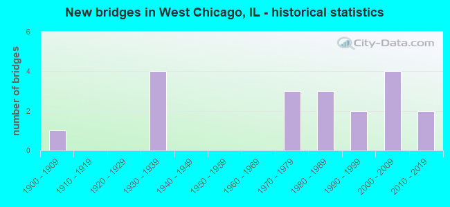
- New bridges - historical statistics
- 11900-1909
- 41930-1939
- 31970-1979
- 31980-1989
- 21990-1999
- 42000-2009
- 22010-2019
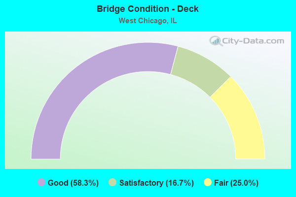
- Bridge Condition - Deck
- 58.3%Good
- 16.7%Satisfactory
- 25.0%Fair
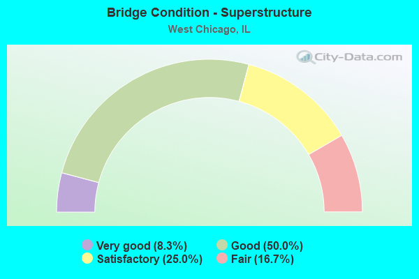
- Bridge Condition - Superstructure
- 8.3%Very good
- 50.0%Good
- 25.0%Satisfactory
- 16.7%Fair
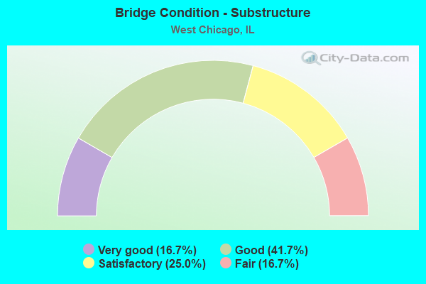
- Bridge Condition - Substructure
- 16.7%Very good
- 41.7%Good
- 25.0%Satisfactory
- 16.7%Fair
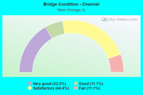
- Bridge Condition - Channel
- 33.3%Very good
- 11.1%Good
- 44.4%Satisfactory
- 11.1%Fair
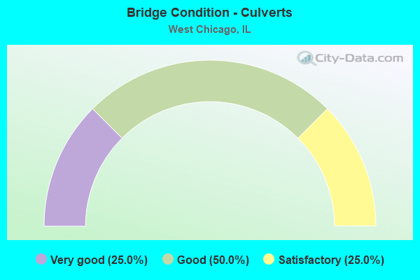
- Bridge Condition - Culverts
- 25.0%Very good
- 50.0%Good
- 25.0%Satisfactory
Find on map >> Show street view
Structure Number: 220022, Location: 0.1 M E OF IL 59 (Lat: 41.861314, Lng: -88.192447), Route carried "on" structure: State highway 38, Year Built: 1933, Year Reconstructed: 1984, Status: Open, Structure Length: 3.90m (12.80ft), Average Daily Traffic: 18,300 (year 2021), Truck Traffic: 8%, Average Future Daily Traffic: 20,720 (year 2032), Design Load: HS 20, Features Intersected: W BR DUPAGE RIVER
Minimum Vertical Clearance: 30+ m (98+ ft), Kilometerpoint: 117.624, Lanes on structure: 4, Base Highway Network: Yes, Owner: State Highway Agency, Approaching Roadway Width: 19.5m (64.0ft), Material/Design: Steel continuous, Design/Construction: Stringer/Multi-beam, Number Of Spans In Main Unit: 2, Length of Maximum Span: 19.0m (62.3ft), Curb-To-Curb Width: 19.5m (64.0ft), Out-to-Out Width: 20.5m (67.3ft)
Condition: Deck: Good, Superstructure: Good, Substructure: Good, Channel: Satisfactory, Operating Rating: 55.7 metric tons, Method Used To Determine Operating Rating: Load Factor (LF) rating reported by rating factor (RF) method using MS18 loading, Inventory Rating: 33.4 metric tons, Method Used To Determine Inventory Rating: Load Factor (LF) rating reported by rating factor (RF) method using MS18 loading, Structural Evaluation: Better than present minimum criteria, Deck Geometry: Better than present minimum criteria, Waterway Adequacy: Equal to present desirable criteria, Approach Roadway Alignment: Equal to present desirable criteria, Length Of Structure Improvement: 3.90m (12.80ft), Designated Inspection Frequency: Every 24 months, Inspection Date: April 2021, Bridge Improvement Cost: $618,000, Roadway Improvement Cost: $62,000, Total Project Cost: $927,000, Deck Structure Type: Concrete Cast-file-Place, Wearing Surface/Protective System: Wearing Surface: Latex Concrete, Deck Protection: Epoxy Coated Reinforcing
Find on map >> Show street view
Structure Number: 220036, Location: 3.9 M S OF IL 64 (Lat: 41.862122, Lng: -88.194844), Route carried "on" structure: State highway 59, Year Built: 1933, Year Reconstructed: 1975, Status: Open, Structure Length: 2.24m (7.35ft), Average Daily Traffic: 30,200 (year 2021), Truck Traffic: 10%, Average Future Daily Traffic: 32,863 (year 2032), Design Load: H 15, Features Intersected: IL 38
Minimum Vertical Clearance: 30+ m (98+ ft), Kilometerpoint: 39.878, Lanes on structure: 4, Lanes under structure: 4, Base Highway Network: Yes, Owner: State Highway Agency, Approaching Roadway Width: 16.5m (54.1ft), Skew: 32 degrees, Material/Design: Steel, Design/Construction: Stringer/Multi-beam, Number Of Spans In Main Unit: 1, Length of Maximum Span: 21.0m (68.9ft), Curb or Sidewalk Widths: Left: 1.5m (4.9ft), Right: 1.5m (4.9ft), Curb-To-Curb Width: 16.5m (54.1ft), Out-to-Out Width: 24.4m (80.1ft)
Condition: Deck: Fair, Superstructure: Fair, Substructure: Fair, Operating Rating: 63.5 metric tons, Method Used To Determine Operating Rating: Load Factor (LF) rating reported by rating factor (RF) method using MS18 loading, Inventory Rating: 37.9 metric tons, Method Used To Determine Inventory Rating: Load Factor (LF) rating reported by rating factor (RF) method using MS18 loading, Structural Evaluation: Somewhat better than minimum adequacy, Deck Geometry: Meets minimum limits, Underclear: Meets minimum limits, Approach Roadway Alignment: Equal to present desirable criteria, Designated Inspection Frequency: Every 24 months, Inspection Date: November 2020, Deck Structure Type: Concrete Cast-file-Place, Wearing Surface/Protective System: Wearing Surface: Latex Concrete, Membrane: Built-up
Find on map >> Show street view
Structure Number: 220037, Location: 0.7 M S OF IL 38 (Lat: 41.853044, Lng: -88.201856), Route carried "on" structure: State highway 59, Year Built: 1931, Year Reconstructed: 1975, Status: Open, Structure Length: 1.85m (6.07ft), Average Daily Traffic: 26,500 (year 2021), Truck Traffic: 11%, Average Future Daily Traffic: 32,863 (year 2032), Design Load: HS 20, Features Intersected: KRESS CREEK
Minimum Vertical Clearance: 30+ m (98+ ft), Kilometerpoint: 38.639, Lanes on structure: 4, Base Highway Network: Yes, Owner: State Highway Agency, Approaching Roadway Width: 20.3m (66.6ft), Skew: 22 degrees, Material/Design: Prestressed concrete, Design/Construction: Stringer/Multi-beam, Number Of Spans In Main Unit: 1, Length of Maximum Span: 16.5m (54.1ft), Curb-To-Curb Width: 20.3m (66.6ft), Out-to-Out Width: 21.3m (69.9ft)
Condition: Deck: Satisfactory, Superstructure: Satisfactory, Substructure: Satisfactory, Channel: Very good, Operating Rating: 71.9 metric tons, Method Used To Determine Operating Rating: Load Factor (LF) rating reported by rating factor (RF) method using MS18 loading, Inventory Rating: 41.8 metric tons, Method Used To Determine Inventory Rating: Load Factor (LF) rating reported by rating factor (RF) method using MS18 loading, Structural Evaluation: Equal to present minimum criteria, Deck Geometry: Equal to present desirable criteria, Waterway Adequacy: Better than present minimum criteria, Approach Roadway Alignment: Equal to present desirable criteria, Length Of Structure Improvement: 1.86m (6.10ft), Designated Inspection Frequency: Every 24 months, Inspection Date: September 2020, Bridge Improvement Cost: $305,000, Roadway Improvement Cost: $31,000, Total Project Cost: $458,000, Deck Structure Type: Concrete Cast-file-Place, Wearing Surface/Protective System: Wearing Surface: Latex Concrete
Find on map >> Show street view
Structure Number: 220143, Location: 1.25 M N OF IL 38 (Lat: 41.879642, Lng: -88.194633), Route carried "on" structure: State highway 59, Year Built: 1975, Status: Open, Structure Length: 6.22m (20.41ft), Average Daily Traffic: 34,200 (year 2021), Truck Traffic: 9%, Average Future Daily Traffic: 35,314 (year 2032), Design Load: HS 20, Features Intersected: RR - UP & CN
Minimum Vertical Clearance: 30+ m (98+ ft), Kilometerpoint: 41.826, Lanes on structure: 4, Base Highway Network: Yes, Owner: State Highway Agency, Approaching Roadway Width: 20.7m (67.9ft), Skew: 22 degrees, Material/Design: Steel continuous, Design/Construction: Stringer/Multi-beam, Number Of Spans In Main Unit: 3, Length of Maximum Span: 22.5m (73.8ft), Curb or Sidewalk Widths: Left: 1.5m (4.9ft), Right: 1.5m (4.9ft), Curb-To-Curb Width: 20.7m (67.9ft), Out-to-Out Width: 24.4m (80.1ft)
Condition: Deck: Fair, Superstructure: Satisfactory, Substructure: Fair, Operating Rating: 70.3 metric tons, Method Used To Determine Operating Rating: Load Factor (LF) rating reported by rating factor (RF) method using MS18 loading, Inventory Rating: 36.6 metric tons, Method Used To Determine Inventory Rating: Load Factor (LF) rating reported by rating factor (RF) method using MS18 loading, Structural Evaluation: Somewhat better than minimum adequacy, Deck Geometry: Superior to present desirable criteria, Underclear: Better than present minimum criteria, Approach Roadway Alignment: Equal to present desirable criteria, Designated Inspection Frequency: Every 24 months, Inspection Date: November 2020, Deck Structure Type: Concrete Cast-file-Place, Wearing Surface/Protective System: Wearing Surface: Latex Concrete, Membrane: Built-up
Find on map >> Show street view
Structure Number: 220144, Location: 0.66 M S OF IL 64 (Lat: 41.907306, Lng: -88.204831), Route carried "on" structure: State highway 59, Year Built: 1975, Status: Open, Structure Length: 5.11m (16.77ft), Average Daily Traffic: 25,900 (year 2021), Truck Traffic: 8%, Average Future Daily Traffic: 28,296 (year 2032), Design Load: HS 20, Features Intersected: ABANDONED RR
Minimum Vertical Clearance: 30+ m (98+ ft), Kilometerpoint: 45.286, Lanes on structure: 4, Base Highway Network: Yes, Owner: State Highway Agency, Approaching Roadway Width: 20.7m (67.9ft), Skew: 21 degrees, Material/Design: Steel continuous, Design/Construction: Stringer/Multi-beam, Number Of Spans In Main Unit: 3, Length of Maximum Span: 18.3m (60.0ft), Curb or Sidewalk Widths: Left: 1.5m (4.9ft), Right: 0.0m, Curb-To-Curb Width: 20.7m (67.9ft), Out-to-Out Width: 22.9m (75.1ft)
Condition: Deck: Fair, Superstructure: Fair, Substructure: Satisfactory, Operating Rating: 69.3 metric tons, Method Used To Determine Operating Rating: Load Factor (LF) rating reported by rating factor (RF) method using MS18 loading, Inventory Rating: 41.8 metric tons, Method Used To Determine Inventory Rating: Load Factor (LF) rating reported by rating factor (RF) method using MS18 loading, Structural Evaluation: Somewhat better than minimum adequacy, Deck Geometry: Superior to present desirable criteria, Underclear: Superior to present desirable criteria, Approach Roadway Alignment: Equal to present minimum criteria, Designated Inspection Frequency: Every 24 months, Inspection Date: November 2020, Deck Structure Type: Concrete Cast-file-Place, Wearing Surface/Protective System: Wearing Surface: Latex Concrete, Membrane: Built-up
Find on map >> Show street view
Structure Number: 220153, Location: 0.41-MI E.OF ILL 59 (Lat: 41.914183, Lng: -88.201561), Route carried "on" structure: State highway 64, Year Built: 1985, Status: Open, Structure Length: 0.80m (2.62ft), Average Daily Traffic: 33,600 (year 2021), Truck Traffic: 11%, Average Future Daily Traffic: 34,050 (year 2032), Design Load: HS 20, Features Intersected: IL PRAIRIE PATH
Minimum Vertical Clearance: 30+ m (98+ ft), Kilometerpoint: 174.899, Lanes on structure: 4, Base Highway Network: Yes, Owner: State Highway Agency, Approaching Roadway Width: 18.3m (60.0ft), Skew: 5 degrees, Material/Design: Concrete, Design/Construction: Culvert, Number Of Spans In Main Unit: 1, Length of Maximum Span: 7.4m (24.3ft)
Condition: Culverts: Good, Operating Rating: 72.9 metric tons, Method Used To Determine Operating Rating: Load Factor (LF) rating reported by rating factor (RF) method using MS18 loading, Inventory Rating: 44.1 metric tons, Method Used To Determine Inventory Rating: Load Factor (LF) rating reported by rating factor (RF) method using MS18 loading, Structural Evaluation: Better than present minimum criteria, Approach Roadway Alignment: Better than present minimum criteria, Designated Inspection Frequency: Every 48 months, Inspection Date: October 2020
Find on map >> Show street view
Structure Number: 220162, Location: 0.02 M E OF IL 59 (Lat: 41.858181, Lng: -88.193658), Route carried "on" structure: Other road , Year Built: 1988, Status: Open, Structure Length: 3.87m (12.70ft), Average Daily Traffic: 5,300 (year 2021), Truck Traffic: 3%, Average Future Daily Traffic: 3,955 (year 2032), Design Load: HS 20, Features Intersected: W BR DU PAGE RIVER, Facility Carried by Structure: GARY MILL RD
Minimum Vertical Clearance: 30+ m (98+ ft), Kilometerpoint: 0.097, Lanes on structure: 2, Owner: State Highway Agency, Approaching Roadway Width: 9.2m (30.2ft), Material/Design: Steel continuous, Design/Construction: Stringer/Multi-beam, Number Of Spans In Main Unit: 3, Length of Maximum Span: 14.6m (47.9ft), Curb-To-Curb Width: 9.2m (30.2ft), Out-to-Out Width: 10.2m (33.5ft)
Condition: Deck: Good, Superstructure: Good, Substructure: Very good, Channel: Very good, Operating Rating: 66.7 metric tons, Method Used To Determine Operating Rating: Load Factor (LF) rating reported by rating factor (RF) method using MS18 loading, Inventory Rating: 39.5 metric tons, Method Used To Determine Inventory Rating: Load Factor (LF) rating reported by rating factor (RF) method using MS18 loading, Structural Evaluation: Better than present minimum criteria, Deck Geometry: High priority of corrective action, Waterway Adequacy: Better than present minimum criteria, Approach Roadway Alignment: Better than present minimum criteria, Designated Inspection Frequency: Every 48 months, Inspection Date: April 2019, Deck Structure Type: Concrete Cast-file-Place, Wearing Surface/Protective System: Deck Protection: Epoxy Coated Reinforcing
Find on map >> Show street view
Structure Number: 220176, Location: 1.8 MI E OF IL 59 (Lat: 41.911006, Lng: -88.179028), Route carried "on" structure: State highway 64, Year Built: 2001, Status: Open, Structure Length: 3.15m (10.33ft), Average Daily Traffic: 35,000 (year 2021), Truck Traffic: 12%, Average Future Daily Traffic: 21,166 (year 2032), Design Load: HS 20, Features Intersected: W BR DUPAGE RIVER
Minimum Vertical Clearance: 30+ m (98+ ft), Kilometerpoint: 176.798, Lanes on structure: 3, Base Highway Network: Yes, Owner: State Highway Agency, Approaching Roadway Width: 15.6m (51.2ft), Material/Design: Concrete continuous, Design/Construction: Slab, Number Of Spans In Main Unit: 3, Length of Maximum Span: 10.4m (34.1ft), Curb-To-Curb Width: 15.6m (51.2ft), Out-to-Out Width: 16.6m (54.5ft)
Condition: Deck: Good, Superstructure: Good, Substructure: Good, Channel: Satisfactory, Operating Rating: 62.9 metric tons, Method Used To Determine Operating Rating: Load Factor (LF) rating reported by rating factor (RF) method using MS18 loading, Inventory Rating: 37.6 metric tons, Method Used To Determine Inventory Rating: Load Factor (LF) rating reported by rating factor (RF) method using MS18 loading, Structural Evaluation: Better than present minimum criteria, Deck Geometry: Equal to present minimum criteria, Waterway Adequacy: Superior to present desirable criteria, Approach Roadway Alignment: Equal to present desirable criteria, Designated Inspection Frequency: Every 48 months, Inspection Date: January 2020, Deck Structure Type: Concrete Cast-file-Place, Wearing Surface/Protective System: Deck Protection: Epoxy Coated Reinforcing
Find on map >> Show street view
Structure Number: 220178, Location: 1.8 M E OF IL 59 (Lat: 41.910986, Lng: -88.178833), Route carried "on" structure: State highway 64, Year Built: 2001, Status: Open, Structure Length: 3.15m (10.33ft), Average Daily Traffic: 35,000 (year 2021), Truck Traffic: 12%, Average Future Daily Traffic: 21,166 (year 2032), Design Load: HS 20, Features Intersected: W BR DU PAGE RIVER
Minimum Vertical Clearance: 30+ m (98+ ft), Kilometerpoint: 176.814, Lanes on structure: 3, Base Highway Network: Yes, Owner: State Highway Agency, Approaching Roadway Width: 15.6m (51.2ft), Material/Design: Concrete continuous, Design/Construction: Slab, Number Of Spans In Main Unit: 3, Length of Maximum Span: 10.4m (34.1ft), Curb-To-Curb Width: 15.6m (51.2ft), Out-to-Out Width: 16.6m (54.5ft)
Condition: Deck: Good, Superstructure: Good, Substructure: Good, Channel: Satisfactory, Operating Rating: 62.9 metric tons, Method Used To Determine Operating Rating: Load Factor (LF) rating reported by rating factor (RF) method using MS18 loading, Inventory Rating: 37.6 metric tons, Method Used To Determine Inventory Rating: Load Factor (LF) rating reported by rating factor (RF) method using MS18 loading, Structural Evaluation: Better than present minimum criteria, Deck Geometry: Equal to present minimum criteria, Waterway Adequacy: Superior to present desirable criteria, Approach Roadway Alignment: Equal to present desirable criteria, Designated Inspection Frequency: Every 48 months, Inspection Date: January 2020, Deck Structure Type: Concrete Cast-file-Place, Wearing Surface/Protective System: Deck Protection: Epoxy Coated Reinforcing
Find on map >> Show street view
Structure Number: 22018, Location: 0.5 M W ST CHAS RD (Lat: 41.910206, Lng: -88.172017), Route carried "on" structure: State highway 64, Year Built: 2001, Status: Open, Structure Length: 1.17m (3.84ft), Average Daily Traffic: 35,000 (year 2021), Truck Traffic: 12%, Average Future Daily Traffic: 42,332 (year 2032), Design Load: HS 20, Features Intersected: W BR DUPAGE RV TRB#4
Minimum Vertical Clearance: 30+ m (98+ ft), Kilometerpoint: 177.377, Lanes on structure: 6, Base Highway Network: Yes, Owner: State Highway Agency, Approaching Roadway Width: 28.8m (94.5ft), Skew: 35 degrees, Material/Design: Concrete, Design/Construction: Culvert, Number Of Spans In Main Unit: 2, Length of Maximum Span: 3.3m (10.8ft)
Condition: Channel: Satisfactory, Culverts: Good, Operating Rating: 44.1 metric tons, Method Used To Determine Operating Rating: Load Factor (LF) rating reported by rating factor (RF) method using MS18 loading, Inventory Rating: 32.4 metric tons, Method Used To Determine Inventory Rating: Load Factor (LF) rating reported by rating factor (RF) method using MS18 loading, Structural Evaluation: Better than present minimum criteria, Waterway Adequacy: Superior to present desirable criteria, Approach Roadway Alignment: Equal to present desirable criteria, Designated Inspection Frequency: Every 24 months, Inspection Date: September 2021
Find on map >> Show street view
Structure Number: 22019, Location: 1.35 M W OF IL 59 (Lat: 41.919419, Lng: -88.235208), Route carried "on" structure: State highway 64, Year Built: 2012, Status: Open, Structure Length: 9.13m (29.95ft), Average Daily Traffic: 33,400 (year 2021), Truck Traffic: 11%, Average Future Daily Traffic: 50,200 (year 2037), Design Load: HS 20, Features Intersected: RR - EJ&E AND UP
Minimum Vertical Clearance: 30+ m (98+ ft), Kilometerpoint: 172.034, Lanes on structure: 4, Base Highway Network: Yes, Owner: State Highway Agency, Approaching Roadway Width: 30.5m (100.1ft), Skew: 30 degrees, Material/Design: Steel continuous, Design/Construction: Stringer/Multi-beam, Number Of Spans In Main Unit: 4, Length of Maximum Span: 26.6m (87.3ft), Curb-To-Curb Width: 30.5m (100.1ft), Out-to-Out Width: 39.4m (129.3ft)
Condition: Deck: Good, Superstructure: Very good, Substructure: Good, Operating Rating: 97.2 metric tons, Method Used To Determine Operating Rating: Load Factor (LF) rating reported by rating factor (RF) method using MS18 loading, Inventory Rating: 57.3 metric tons, Method Used To Determine Inventory Rating: Load Factor (LF) rating reported by rating factor (RF) method using MS18 loading, Structural Evaluation: Better than present minimum criteria, Deck Geometry: Superior to present desirable criteria, Underclear: Superior to present desirable criteria, Approach Roadway Alignment: Equal to present minimum criteria, Designated Inspection Frequency: Every 48 months, Inspection Date: August 2019, Deck Structure Type: Concrete Cast-file-Place, Wearing Surface/Protective System: Deck Protection: Epoxy Coated Reinforcing
Find on map >> Show street view
Structure Number: 223031, Location: 1.5 MI E IL-59 (Lat: 41.912872, Lng: -88.179681), Route carried "on" structure: County highway , Year Built: 2005, Status: Open, Structure Length: 3.32m (10.89ft), Average Daily Traffic: 275 (year 2020), Truck Traffic: 4%, Average Future Daily Traffic: 2,117 (year 2032), Design Load: HS 25 or greater, Features Intersected: W BRANCH DUPAGE RIV, Facility Carried by Structure: ST CHARLES RD
Minimum Vertical Clearance: 30+ m (98+ ft), Kilometerpoint: 0.402, Lanes on structure: 2, Owner: Town or Township Highway Agency, Approaching Roadway Width: 6.7m (22.0ft), Material/Design: Concrete, Design/Construction: Slab, Number Of Spans In Main Unit: 3, Length of Maximum Span: 12.8m (42.0ft), Curb-To-Curb Width: 9.1m (29.9ft), Out-to-Out Width: 9.8m (32.2ft)
Condition: Deck: Good, Superstructure: Good, Substructure: Very good, Channel: Good, Operating Rating: 44.1 metric tons, Method Used To Determine Operating Rating: Assigned rating based on Load Factor Design (LFD) reported by rating factor (RF) using MS18 loading, Inventory Rating: 32.4 metric tons, Method Used To Determine Inventory Rating: Assigned rating based on Load Factor Design (LFD) reported by rating factor (RF) using MS18 loading, Structural Evaluation: Better than present minimum criteria, Deck Geometry: Equal to present minimum criteria, Waterway Adequacy: Equal to present desirable criteria, Approach Roadway Alignment: Equal to present desirable criteria, Designated Inspection Frequency: Every 48 months, Inspection Date: June 2018, Deck Structure Type: Concrete Cast-file-Place
Find on map >> Show street view
Structure Number: 22304, Location: 0.66 MI S OF IL 38 (Lat: 41.870322, Lng: -88.243850), Route carried "on" structure: Other road , Year Built: 1971, Status: Open, Structure Length: 0.84m (2.76ft), Average Daily Traffic: 8,800 (year 2020), Truck Traffic: 13%, Average Future Daily Traffic: 16,821 (year 2032), Design Load: HS 20, Features Intersected: KRESS CREEK, Facility Carried by Structure: FABYAN PARKWAY
Minimum Vertical Clearance: 30+ m (98+ ft), Kilometerpoint: 1.577, Lanes on structure: 2, Base Highway Network: Yes, Owner: County Highway Agency, Approaching Roadway Width: 15.2m (49.9ft), Skew: 1 degrees, Material/Design: Concrete, Design/Construction: Culvert, Number Of Spans In Main Unit: 2, Length of Maximum Span: 4.1m (13.5ft)
Condition: Channel: Fair, Culverts: Satisfactory, Operating Rating: 67.1 metric tons, Method Used To Determine Operating Rating: Load Factor (LF) rating reported by rating factor (RF) method using MS18 loading, Inventory Rating: 40.2 metric tons, Method Used To Determine Inventory Rating: Load Factor (LF) rating reported by rating factor (RF) method using MS18 loading, Structural Evaluation: Equal to present minimum criteria, Waterway Adequacy: Better than present minimum criteria, Approach Roadway Alignment: Equal to present desirable criteria, Designated Inspection Frequency: Every 24 months, Inspection Date: September 2021
Find on map >> Show street view
Structure Number: 223103, Location: 0.3 MI N OF IL 38 (Lat: 41.883250, Lng: -88.244247), Route carried "on" structure: Other road , Year Built: 1992, Status: Open, Structure Length: 6.80m (22.31ft), Average Daily Traffic: 5,900 (year 2020), Truck Traffic: 22%, Average Future Daily Traffic: 7,464 (year 2032), Design Load: HS 20, Features Intersected: UP RAILROAD CO, Facility Carried by Structure: KRESS RD
Minimum Vertical Clearance: 30+ m (98+ ft), Kilometerpoint: 1.802, Lanes on structure: 2, Owner: County Highway Agency, Approaching Roadway Width: 15.5m (50.9ft), Material/Design: Prestressed concrete, Design/Construction: Stringer/Multi-beam, Number Of Spans In Main Unit: 3, Length of Maximum Span: 30.5m (100.1ft), Curb or Sidewalk Widths: Left: 1.5m (4.9ft), Right: 1.5m (4.9ft), Curb-To-Curb Width: 15.5m (50.9ft), Out-to-Out Width: 19.2m (63.0ft)
Condition: Deck: Satisfactory, Superstructure: Satisfactory, Substructure: Satisfactory, Operating Rating: 71.6 metric tons, Method Used To Determine Operating Rating: Load Factor (LF) rating reported by rating factor (RF) method using MS18 loading, Inventory Rating: 43.1 metric tons, Method Used To Determine Inventory Rating: Load Factor (LF) rating reported by rating factor (RF) method using MS18 loading, Structural Evaluation: Equal to present minimum criteria, Deck Geometry: Superior to present desirable criteria, Underclear: Superior to present desirable criteria, Approach Roadway Alignment: Equal to present minimum criteria, Designated Inspection Frequency: Every 24 months, Inspection Date: October 2020, Deck Structure Type: Concrete Cast-file-Place, Wearing Surface/Protective System: Deck Protection: Epoxy Coated Reinforcing
Find on map >> Show street view
Structure Number: 226006, Location: 0.25 M. W.OF IL 59 (Lat: 41.856439, Lng: -88.204369), Route carried "on" structure: Other road , Year Built: 2013, Status: Open, Structure Length: 0.87m (2.85ft), Average Daily Traffic: 8,500 (year 2020), Truck Traffic: 6%, Average Future Daily Traffic: 12,477 (year 2032), Design Load: HS 25 or greater, Features Intersected: KRESS CREEK, Facility Carried by Structure: JOLIET AND WILSON
Minimum Vertical Clearance: 30+ m (98+ ft), Kilometerpoint: 3.235, Lanes on structure: 2, Owner: City or Municipal Highway Agency, Approaching Roadway Width: 7.5m (24.6ft), Skew: 4 degrees, Material/Design: Concrete, Design/Construction: Culvert, Number Of Spans In Main Unit: 2, Length of Maximum Span: 4.0m (13.1ft), Curb-To-Curb Width: 27.7m (90.9ft), Out-to-Out Width: 40.2m (131.9ft)
Condition: Channel: Very good, Culverts: Very good, Operating Rating: 42.1 metric tons, Method Used To Determine Operating Rating: Assigned ratings based on Load and Resistance Factor Design (LRFD) reported by rating factor (RF) using HL93 loadings, Inventory Rating: 32.4 metric tons, Method Used To Determine Inventory Rating: Assigned ratings based on Load and Resistance Factor Design (LRFD) reported by rating factor (RF) using HL93 loadings, Structural Evaluation: Equal to present desirable criteria, Deck Geometry: Superior to present desirable criteria, Waterway Adequacy: Superior to present desirable criteria, Approach Roadway Alignment: Equal to present desirable criteria, Designated Inspection Frequency: Every 48 months, Inspection Date: October 2018, Deck Structure Type: Other
Find on map >> Show street view
Structure Number: 227101, Location: S.OF MAIN ST. (Lat: 41.881553, Lng: -88.199639), Route carried "on" structure: City street , Year Built: 1987, Status: Open, Structure Length: 13.11m (43.01ft), Average Daily Traffic: 2,400 (year 2020), Truck Traffic: 5%, Average Future Daily Traffic: 5,580 (year 2032), Design Load: HS 20+Mod, Features Intersected: C&NW RR, Facility Carried by Structure: WILSON AVE
Minimum Vertical Clearance: 30+ m (98+ ft), Kilometerpoint: 0.048, Lanes on structure: 2, Owner: City or Municipal Highway Agency, Approaching Roadway Width: 9.1m (29.9ft), Skew: 1 degrees, Material/Design: Steel continuous, Design/Construction: Stringer/Multi-beam, Number Of Spans In Main Unit: 5, Number Of Approach Spans: 2, Length of Maximum Span: 29.0m (95.1ft), Curb or Sidewalk Widths: Left: 1.8m (5.9ft), Right: 1.8m (5.9ft), Curb-To-Curb Width: 9.1m (29.9ft), Out-to-Out Width: 13.4m (44.0ft)
Condition: Deck: Good, Superstructure: Good, Substructure: Good, Operating Rating: 44.4 metric tons, Method Used To Determine Operating Rating: Assigned rating based on Load Factor Design (LFD) reported by rating factor (RF) using MS18 loading, Inventory Rating: 32.4 metric tons, Method Used To Determine Inventory Rating: Assigned rating based on Load Factor Design (LFD) reported by rating factor (RF) using MS18 loading, Structural Evaluation: Better than present minimum criteria, Deck Geometry: Meets minimum limits, Underclear: Equal to present minimum criteria, Approach Roadway Alignment: Better than present minimum criteria, Designated Inspection Frequency: Every 48 months, Inspection Date: October 2018, Deck Structure Type: Concrete Cast-file-Place, Wearing Surface/Protective System: Wearing Surface: Latex Concrete, Deck Protection: Epoxy Coated Reinforcing
Find on map >> Show street view
Structure Number: 220021, Location: W OF JOLIET RD (Lat: 41.866872, Lng: -88.210364), Route carried "under" structure: State highway 38, Year Built: 1900, Structure Length: 0. m, Average Daily Traffic: 29,600 (year 2021), Truck Traffic: 15%, Features Intersected: ILL 38, Facility Carried by Structure: EJ&E RR
Minimum Vertical Clearance: 4.34m (14.24ft), Kilometerpoint: 116.047, Lanes under structure: 4, Material/Design: Steel, Design/Construction: Girder and Floorbeam System, Length of Maximum Span: 8.3m (27.2ft)
Find on map >> Show street view
Structure Number: 220036, Location: 3.9 M S OF IL 64 (Lat: 41.862122, Lng: -88.194844), Route carried "under" structure: State highway 38, Year Built: 1933, Structure Length: 0. m, Average Daily Traffic: 18,300 (year 2021), Truck Traffic: 8%, Features Intersected: IL 38, Facility Carried by Structure: IL 59
Minimum Vertical Clearance: 4.34m (14.24ft), Kilometerpoint: 117.447, Lanes on structure: 4, Lanes under structure: 4, Material/Design: Steel, Design/Construction: Stringer/Multi-beam, Length of Maximum Span: 21.0m (68.9ft)
Find on map >> Show street view
Structure Number: 220168, Location: .5 MI NO OF IL-64 (Lat: 41.921125, Lng: -88.208867), Route carried "under" structure: State highway 59, Year Built: 1993, Structure Length: 0. m, Average Daily Traffic: 30,800 (year 2021), Truck Traffic: 8%, Features Intersected: IL59, Facility Carried by Structure: PRAIRIE PATH
Minimum Vertical Clearance: 5.31m (17.42ft), Kilometerpoint: 46.927, Lanes under structure: 2, Length of Maximum Span: 38.1m (125.0ft)