Bridge Statistics for West Hills, Pennsylvania (PA)
Condition, Traffic, Stress, Structural Evaluation, Project Costs
- National Bridge Inventory (NBI) Statistics
- 29Number of bridges
- 135ft / 40.8mTotal length
- $116,000Total costs
- 136,052Total average daily traffic
- 14,171Total average daily truck traffic
- National Bridge Inventory (NBI) Registered Bridges for West Hills
- No street view available for this location
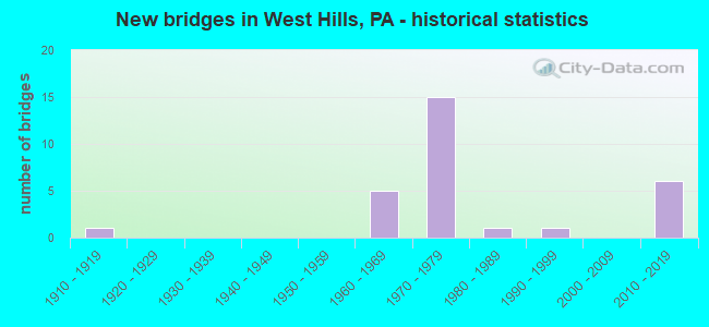
- New bridges - historical statistics
- 11910-1919
- 51960-1969
- 151970-1979
- 11980-1989
- 11990-1999
- 62010-2019


- Bridge Condition - Deck
- 12.5%Excellent
- 12.5%Very good
- 25.0%Good
- 37.5%Satisfactory
- 12.5%Fair

- Bridge Condition - Superstructure
- 12.5%Excellent
- 12.5%Very good
- 25.0%Good
- 37.5%Satisfactory
- 12.5%Fair

- Bridge Condition - Substructure
- 12.5%Excellent
- 12.5%Very good
- 25.0%Good
- 25.0%Satisfactory
- 25.0%Fair

- Bridge Condition - Channel
- 20.0%Very good
- 40.0%Fair
- 40.0%Poor

- Bridge Condition - Culverts
- 50.0%Satisfactory
- 50.0%Fair
Find on map >> Show street view
Structure Number: 2956, Location: MCHADDON NO.2 SB (Lat: 40.781156, Lng: -79.587967), Route carried "on" structure: State highway 28, Year Built: 1968, Status: Open, Structure Length: 3.57m (11.71ft), Average Daily Traffic: 7,383 (year 2021), Truck Traffic: 9%, Average Future Daily Traffic: 8,621 (year 2032), Design Load: HS 20+Mod, Features Intersected: T-435 MCHADDON RD
Minimum Vertical Clearance: 30+ m (98+ ft), Kilometerpoint: 13.203, Lanes on structure: 2, Lanes under structure: 2, Base Highway Network: Yes, Owner: State Highway Agency, Approaching Roadway Width: 10.7m (35.1ft), Skew: 13 degrees, Material/Design: Prestressed concrete, Design/Construction: Box Beam or Girders - Single/Spread, Number Of Spans In Main Unit: 3, Length of Maximum Span: 12.2m (40.0ft), Curb or Sidewalk Widths: Left: 0.2m (0.7ft), Right: 0.2m (0.7ft), Curb-To-Curb Width: 12.1m (39.7ft), Out-to-Out Width: 13.4m (44.0ft)
Condition: Deck: Satisfactory, Superstructure: Satisfactory, Substructure: Satisfactory, Operating Rating: 49.0 metric tons, Method Used To Determine Operating Rating: Load Factor (LF), Inventory Rating: 29.0 metric tons, Method Used To Determine Inventory Rating: Load Factor (LF), Structural Evaluation: Equal to present minimum criteria, Deck Geometry: Better than present minimum criteria, Underclear: Meets minimum limits, Approach Roadway Alignment: Equal to present desirable criteria, Length Of Structure Improvement: 4.50m (14.76ft), Designated Inspection Frequency: Every 24 months, Inspection Date: July 2021, Deck Structure Type: Concrete Cast-file-Place, Wearing Surface/Protective System: Wearing Surface: Epoxy Overlay, Membrane: Epoxy, Deck Protection: Epoxy Coated Reinforcing
Find on map >> Show street view
Structure Number: 296, Location: CENTER HILL NO.3 NB (Lat: 40.797364, Lng: -79.570933), Route carried "on" structure: State highway 28, Year Built: 1970, Status: Open, Structure Length: 5.82m (19.09ft), Average Daily Traffic: 7,356 (year 2021), Truck Traffic: 9%, Average Future Daily Traffic: 8,650 (year 2032), Design Load: HS 20, Features Intersected: SR3017
Minimum Vertical Clearance: 30+ m (98+ ft), Kilometerpoint: 15.504, Lanes on structure: 2, Lanes under structure: 2, Base Highway Network: Yes, Owner: State Highway Agency, Approaching Roadway Width: 11.6m (38.1ft), Skew: 14 degrees, Material/Design: Prestressed concrete, Design/Construction: Stringer/Multi-beam, Number Of Spans In Main Unit: 3, Length of Maximum Span: 28.0m (91.9ft), Curb or Sidewalk Widths: Left: 0.2m (0.7ft), Right: 0.2m (0.7ft), Curb-To-Curb Width: 12.4m (40.7ft), Out-to-Out Width: 13.4m (44.0ft)
Condition: Deck: Satisfactory, Superstructure: Satisfactory, Substructure: Good, Operating Rating: 70.8 metric tons, Method Used To Determine Operating Rating: Load Factor (LF), Inventory Rating: 25.4 metric tons, Method Used To Determine Inventory Rating: Load Factor (LF), Structural Evaluation: Equal to present minimum criteria, Deck Geometry: Better than present minimum criteria, Underclear: Equal to present minimum criteria, Approach Roadway Alignment: Equal to present desirable criteria, Length Of Structure Improvement: 6.80m (22.31ft), Designated Inspection Frequency: Every 24 months, Inspection Date: May 2021, Deck Structure Type: Concrete Cast-file-Place, Wearing Surface/Protective System: Wearing Surface: Monolithic Concrete, Deck Protection: Epoxy Coated Reinforcing
Find on map >> Show street view
Structure Number: 2963, Location: CENTER HILL NO.4 (Lat: 40.802278, Lng: -79.567417), Route carried "on" structure: State highway 28, Year Built: 1970, Status: Open, Structure Length: 1.10m (3.61ft), Average Daily Traffic: 14,739 (year 2021), Truck Traffic: 9%, Average Future Daily Traffic: 17,271 (year 2032), Design Load: HS 20, Features Intersected: GLADE RUN
Minimum Vertical Clearance: 30+ m (98+ ft), Kilometerpoint: 15.504, Lanes on structure: 2, Base Highway Network: Yes, Owner: State Highway Agency, Approaching Roadway Width: 23.2m (76.1ft), Skew: 21 degrees, Material/Design: Concrete, Design/Construction: Culvert, Number Of Spans In Main Unit: 1, Length of Maximum Span: 11.0m (36.1ft)
Condition: Channel: Fair, Culverts: Fair, Operating Rating: 46.3 metric tons, Method Used To Determine Operating Rating: Field evaluation and documented engineering judgment, Inventory Rating: 28.1 metric tons, Method Used To Determine Inventory Rating: Field evaluation and documented engineering judgment, Structural Evaluation: Somewhat better than minimum adequacy, Waterway Adequacy: Superior to present desirable criteria, Approach Roadway Alignment: Equal to present desirable criteria, Length Of Structure Improvement: 1.80m (5.91ft), Designated Inspection Frequency: Every 24 months, Inspection Date: August 2021
Find on map >> Show street view
Structure Number: 3055, Location: RTE 268 RAMPS (Lat: 40.812542, Lng: -79.556039), Route carried "on" structure: Ramp State highway 268, Year Built: 1970, Year Reconstructed: 1999, Status: Open, Structure Length: 8.81m (28.90ft), Average Daily Traffic: 14,731 (year 2022), Truck Traffic: 9%, Average Future Daily Traffic: 18,158 (year 2032), Design Load: HS 20, Features Intersected: SR0422 EB&WB
Minimum Vertical Clearance: 30.45m (99.90ft), Kilometerpoint: 0.000, Lanes on structure: 2, Lanes under structure: 4, Base Highway Network: Yes, Owner: State Highway Agency, Approaching Roadway Width: 17.8m (58.4ft), Skew: 32 degrees, Material/Design: Prestressed concrete, Design/Construction: Stringer/Multi-beam, Number Of Spans In Main Unit: 4, Length of Maximum Span: 29.9m (98.1ft), Curb or Sidewalk Widths: Left: 0.2m (0.7ft), Right: 0.2m (0.7ft), Curb-To-Curb Width: 8.9m (29.2ft), Out-to-Out Width: 19.5m (64.0ft)
Condition: Deck: Satisfactory, Superstructure: Satisfactory, Substructure: Fair, Operating Rating: 58.1 metric tons, Method Used To Determine Operating Rating: Load Factor (LF), Inventory Rating: 26.3 metric tons, Method Used To Determine Inventory Rating: Load Factor (LF), Structural Evaluation: Somewhat better than minimum adequacy, Deck Geometry: Meets minimum limits, Underclear: High priority of corrective action, Approach Roadway Alignment: Better than present minimum criteria, Length Of Structure Improvement: 9.80m (32.15ft), Designated Inspection Frequency: Every 24 months, Inspection Date: November 2020, Deck Structure Type: Concrete Cast-file-Place, Wearing Surface/Protective System: Wearing Surface: Monolithic Concrete, Deck Protection: Epoxy Coated Reinforcing
Find on map >> Show street view
Structure Number: 3057, Location: COWAN STATION NO.2 (Lat: 40.863236, Lng: -79.572000), Route carried "on" structure: State highway 268, Year Built: 1988, Status: Open, Structure Length: 1.07m (3.51ft), Average Daily Traffic: 2,951 (year 2022), Truck Traffic: 8%, Average Future Daily Traffic: 3,778 (year 2032), Design Load: HS 20, Features Intersected: GLADE RUN
Minimum Vertical Clearance: 30+ m (98+ ft), Kilometerpoint: 7.810, Lanes on structure: 2, Base Highway Network: Yes, Owner: State Highway Agency, Approaching Roadway Width: 10.1m (33.1ft), Skew: 2 degrees, Material/Design: Concrete continuous, Design/Construction: Culvert, Number Of Spans In Main Unit: 2, Length of Maximum Span: 4.6m (15.1ft), Curb-To-Curb Width: 10.4m (34.1ft), Out-to-Out Width: 12.0m (39.4ft)
Condition: Channel: Poor, Culverts: Satisfactory, Operating Rating: 70.8 metric tons, Method Used To Determine Operating Rating: Load Factor (LF), Inventory Rating: 42.6 metric tons, Method Used To Determine Inventory Rating: Load Factor (LF), Structural Evaluation: Equal to present minimum criteria, Deck Geometry: Somewhat better than minimum adequacy, Waterway Adequacy: Equal to present minimum criteria, Approach Roadway Alignment: Equal to present desirable criteria, Length Of Structure Improvement: 1.80m (5.91ft), Designated Inspection Frequency: Every 48 months, Inspection Date: Febuary 2019, Wearing Surface/Protective System: Wearing Surface: Bituminous, Deck Protection: Epoxy Coated Reinforcing
Find on map >> Show street view
Structure Number: 332, Location: WALKCHALK NO.1 (Lat: 40.835339, Lng: -79.576667), Route carried "on" structure: State highway , Year Built: 1918, Status: Open, Structure Length: 1.13m (3.71ft), Average Daily Traffic: 1,316 (year 2020), Truck Traffic: 3%, Average Future Daily Traffic: 1,934 (year 2032), Design Load: H 20, Features Intersected: GLADE RUN, Facility Carried by Structure: SR4010
Minimum Vertical Clearance: 30+ m (98+ ft), Kilometerpoint: 5.337, Lanes on structure: 2, Owner: State Highway Agency, Approaching Roadway Width: 8.5m (27.9ft), Skew: 2 degrees, Material/Design: Concrete, Design/Construction: Slab, Number Of Spans In Main Unit: 2, Length of Maximum Span: 5.2m (17.1ft), Curb or Sidewalk Widths: Left: 0.5m (1.6ft), Right: 0.5m (1.6ft), Curb-To-Curb Width: 10.2m (33.5ft), Out-to-Out Width: 11.3m (37.1ft)
Condition: Deck: Fair, Superstructure: Fair, Substructure: Fair, Channel: Poor, Operating Rating: 46.3 metric tons, Method Used To Determine Operating Rating: Load Factor (LF), Inventory Rating: 27.2 metric tons, Method Used To Determine Inventory Rating: Load Factor (LF), Structural Evaluation: Somewhat better than minimum adequacy, Deck Geometry: Somewhat better than minimum adequacy, Waterway Adequacy: Equal to present minimum criteria, Approach Roadway Alignment: Better than present minimum criteria, Length Of Structure Improvement: 1.70m (5.58ft), Designated Inspection Frequency: Every 24 months, Inspection Date: January 2021, Bridge Improvement Cost: $9,000, Roadway Improvement Cost: $52,000, Total Project Cost: $116,000, Deck Structure Type: Concrete Cast-file-Place, Wearing Surface/Protective System: Wearing Surface: Bituminous
Find on map >> Show street view
Structure Number: 3368, Location: 1 mile east of SR3007 (Lat: 40.815850, Lng: -79.570131), Route carried "on" structure: City street , Year Built: 1992, Status: Posted for load, Structure Length: 1.01m (3.31ft), Average Daily Traffic: 50 (year 2006), Truck Traffic: 9%, Average Future Daily Traffic: 70 (year 2026), Design Load: HS 20, Features Intersected: GLADE RUN, Facility Carried by Structure: T-531 SOTOS ROAD
Minimum Vertical Clearance: 30+ m (98+ ft), Kilometerpoint: 0.000, Lanes on structure: 1, Owner: Town or Township Highway Agency, Approaching Roadway Width: 4.6m (15.1ft), Material/Design: Wood or Timber, Design/Construction: Slab, Number Of Spans In Main Unit: 1, Length of Maximum Span: 9.8m (32.2ft), Curb-To-Curb Width: 4.9m (16.1ft), Out-to-Out Width: 6.1m (20.0ft)
Condition: Deck: Good, Superstructure: Good, Substructure: Satisfactory, Channel: Fair, Operating Rating: 34.5 metric tons, Method Used To Determine Operating Rating: Allowable Stress (AS), Inventory Rating: 20.9 metric tons, Method Used To Determine Inventory Rating: Allowable Stress (AS), Structural Evaluation: Equal to present minimum criteria, Deck Geometry: High priority of corrective action, Waterway Adequacy: Better than present minimum criteria, Approach Roadway Alignment: Equal to present desirable criteria, Bridge Posting: Required (Relationship of Operating Rating to Maximum Legal Load: 20.0 - 29.9% below), Length Of Structure Improvement: 1.60m (5.25ft), Designated Inspection Frequency: Every 24 months, Other Special Inspection Frequency: Every 12 months, Inspection Date: May 2021, Other Special Inspection Date: May 2021, Wearing Surface/Protective System: Wearing Surface: Bituminous
Find on map >> Show street view
Structure Number: 46197, Location: 1 mi S of COWANSVILLE (Lat: 40.877708, Lng: -79.583022), Route carried "on" structure: State highway 268, Year Built: 2010, Status: Open, Structure Length: 3.54m (11.61ft), Average Daily Traffic: 2,951 (year 2022), Truck Traffic: 8%, Average Future Daily Traffic: 3,778 (year 2032), Design Load: HL 93, Features Intersected: BUFF & PITT RR
Minimum Vertical Clearance: 30+ m (98+ ft), Kilometerpoint: 10.778, Lanes on structure: 2, Base Highway Network: Yes, Owner: State Highway Agency, Approaching Roadway Width: 6.7m (22.0ft), Skew: 3 degrees, Material/Design: Prestressed concrete, Design/Construction: Stringer/Multi-beam, Number Of Spans In Main Unit: 1, Length of Maximum Span: 35.1m (115.2ft), Curb or Sidewalk Widths: Left: 0.2m (0.7ft), Right: 0.2m (0.7ft), Curb-To-Curb Width: 9.8m (32.2ft), Out-to-Out Width: 10.8m (35.4ft)
Condition: Deck: Good, Superstructure: Good, Substructure: Good, Operating Rating: 88.0 metric tons, Method Used To Determine Operating Rating: Load and Resistance Factor (LRFR), Inventory Rating: 43.5 metric tons, Method Used To Determine Inventory Rating: Load and Resistance Factor (LRFR), Structural Evaluation: Better than present minimum criteria, Deck Geometry: Meets minimum limits, Underclear: High priority of corrective action, Approach Roadway Alignment: Equal to present minimum criteria, Designated Inspection Frequency: Every 24 months, Inspection Date: March 2021, Deck Structure Type: Concrete Cast-file-Place, Wearing Surface/Protective System: Wearing Surface: Monolithic Concrete, Deck Protection: Epoxy Coated Reinforcing
Find on map >> Show street view
Structure Number: 52635, Location: Center Hill No. 6 (Lat: 40.799333, Lng: -79.566889), Route carried "on" structure: State highway , Year Built: 2015, Status: Open, Structure Length: 3.02m (9.91ft), Average Daily Traffic: 1,269 (year 2022), Truck Traffic: 13%, Average Future Daily Traffic: 2,447 (year 2037), Design Load: HL 93, Features Intersected: Glade Run, Facility Carried by Structure: Freeport Rd SR3017
Minimum Vertical Clearance: 30+ m (98+ ft), Kilometerpoint: 8.724, Lanes on structure: 2, Owner: State Highway Agency, Maintenance Responsibility: Private, Approaching Roadway Width: 7.9m (25.9ft), Skew: 3 degrees, Material/Design: Prestressed concrete, Design/Construction: Box Beam or Girders - Single/Spread, Number Of Spans In Main Unit: 1, Length of Maximum Span: 28.7m (94.2ft), Curb-To-Curb Width: 8.7m (28.5ft), Out-to-Out Width: 9.3m (30.5ft)
Condition: Deck: Excellent, Superstructure: Excellent, Substructure: Excellent, Channel: Very good, Operating Rating: 53.8 metric tons, Method Used To Determine Operating Rating: Assigned ratings based on Load and Resistance Factor Design (LRFD) reported by rating factor (RF) using HL93 loadings, Inventory Rating: 40.2 metric tons, Method Used To Determine Inventory Rating: Assigned ratings based on Load and Resistance Factor Design (LRFD) reported by rating factor (RF) using HL93 loadings, Structural Evaluation: Superior to present desirable criteria, Deck Geometry: Somewhat better than minimum adequacy, Waterway Adequacy: Superior to present desirable criteria, Approach Roadway Alignment: Better than present minimum criteria, Designated Inspection Frequency: Every 24 months, Inspection Date: August 2021, Deck Structure Type: Concrete Cast-file-Place, Wearing Surface/Protective System: Wearing Surface: Integral Concrete, Deck Protection: Epoxy Coated Reinforcing
Find on map >> Show street view
Structure Number: 54006, Location: BRIAR HILL (Lat: 40.809136, Lng: -79.548136), Route carried "on" structure: State highway , Year Built: 2018, Status: Open, Structure Length: 11.77m (38.62ft), Average Daily Traffic: 1,269 (year 2022), Truck Traffic: 13%, Average Future Daily Traffic: 2,861 (year 2032), Design Load: HL 93, Features Intersected: SR0422 EB/WB & RAMPS F&G, Facility Carried by Structure: Freeport Rd
Minimum Vertical Clearance: 30+ m (98+ ft), Kilometerpoint: 10.662, Lanes on structure: 2, Lanes under structure: 6, Owner: State Highway Agency, Maintenance Responsibility: Private, Approaching Roadway Width: 11.3m (37.1ft), Skew: 1 degrees, Material/Design: Prestressed concrete continuous, Design/Construction: Stringer/Multi-beam, Number Of Spans In Main Unit: 3, Length of Maximum Span: 39.0m (128.0ft), Curb-To-Curb Width: 12.2m (40.0ft), Out-to-Out Width: 12.8m (42.0ft)
Condition: Deck: Very good, Superstructure: Very good, Substructure: Very good, Operating Rating: 54.4 metric tons, Method Used To Determine Operating Rating: Assigned ratings based on Load and Resistance Factor Design (LRFD) reported by rating factor (RF) using HL93 loadings, Inventory Rating: 41.8 metric tons, Method Used To Determine Inventory Rating: Assigned ratings based on Load and Resistance Factor Design (LRFD) reported by rating factor (RF) using HL93 loadings, Structural Evaluation: Equal to present desirable criteria, Deck Geometry: Better than present minimum criteria, Underclear: Better than present minimum criteria, Approach Roadway Alignment: Better than present minimum criteria, Designated Inspection Frequency: Every 24 months, Inspection Date: May 2020, Deck Structure Type: Concrete Cast-file-Place, Wearing Surface/Protective System: Wearing Surface: Integral Concrete, Deck Protection: Epoxy Coated Reinforcing
Find on map >> Show street view
Structure Number: 2953, Location: MCHADDON NO.1 NB (Lat: 40.777183, Lng: -79.597142), Route carried "under" structure: City street , Year Built: 1968, Structure Length: 0. m, Average Daily Traffic: 50 (year 2007), Truck Traffic: 9%, Features Intersected: T-414 CHURCH RD, Facility Carried by Structure: SR0028 NB
Minimum Vertical Clearance: 4.72m (15.49ft), Kilometerpoint: 0.000, Lanes on structure: 2, Lanes under structure: 2, Material/Design: Prestressed concrete, Design/Construction: Box Beam or Girders - Single/Spread, Length of Maximum Span: 11.0m (36.1ft)
Find on map >> Show street view
Structure Number: 2954, Location: MCHADDON NO.1 SB (Lat: 40.777458, Lng: -79.597322), Route carried "under" structure: City street , Year Built: 1968, Structure Length: 0. m, Average Daily Traffic: 50 (year 2007), Truck Traffic: 9%, Features Intersected: T-414 CHURCH RD, Facility Carried by Structure: SR0028 SB
Minimum Vertical Clearance: 4.67m (15.32ft), Kilometerpoint: 0.000, Lanes on structure: 2, Lanes under structure: 2, Material/Design: Prestressed concrete, Design/Construction: Box Beam or Girders - Single/Spread, Length of Maximum Span: 11.6m (38.1ft)
Find on map >> Show street view
Structure Number: 2955, Location: MCHADDON NO.2 NB (Lat: 40.780939, Lng: -79.587667), Route carried "under" structure: City street 7435, Year Built: 1968, Structure Length: 0. m, Average Daily Traffic: 50 (year 2008), Features Intersected: T-435 MCHADDON RD, Facility Carried by Structure: SR0028 NB
Minimum Vertical Clearance: 4.49m (14.73ft), Kilometerpoint: 0.000, Lanes on structure: 2, Lanes under structure: 2, Material/Design: Prestressed concrete, Design/Construction: Box Beam or Girders - Single/Spread, Length of Maximum Span: 12.8m (42.0ft)
Find on map >> Show street view
Structure Number: 2956, Location: MCHADDON NO.2 SB (Lat: 40.781156, Lng: -79.587967), Route carried "under" structure: City street , Year Built: 1968, Structure Length: 0. m, Average Daily Traffic: 50 (year 2008), Features Intersected: T-435 MCHADDON RD, Facility Carried by Structure: SR0028 SB
Minimum Vertical Clearance: 4.40m (14.44ft), Kilometerpoint: 0.000, Lanes on structure: 2, Lanes under structure: 2, Material/Design: Prestressed concrete, Design/Construction: Box Beam or Girders - Single/Spread, Length of Maximum Span: 12.2m (40.0ft)
Find on map >> Show street view
Structure Number: 2957, Location: CENTER HILL NO.1 NB (Lat: 40.787528, Lng: -79.578950), Route carried "under" structure: State highway , Year Built: 1970, Structure Length: 0. m, Average Daily Traffic: 581 (year 2020), Truck Traffic: 3%, Features Intersected: SR3007, Facility Carried by Structure: SR0028 NB
Minimum Vertical Clearance: 4.82m (15.81ft), Kilometerpoint: 3.508, Lanes on structure: 2, Lanes under structure: 2, Material/Design: Prestressed concrete, Design/Construction: Box Beam or Girders - Multiple, Length of Maximum Span: 27.1m (88.9ft)
Find on map >> Show street view
Structure Number: 2958, Location: CENTER HILL NO.1 SB (Lat: 40.787956, Lng: -79.579214), Route carried "under" structure: State highway , Year Built: 1970, Structure Length: 0. m, Average Daily Traffic: 581 (year 2020), Truck Traffic: 3%, Features Intersected: SR3007, Facility Carried by Structure: SR0028 SB
Minimum Vertical Clearance: 4.51m (14.80ft), Kilometerpoint: 3.508, Lanes on structure: 2, Lanes under structure: 2, Material/Design: Prestressed concrete, Design/Construction: Box Beam or Girders - Multiple, Length of Maximum Span: 27.1m (88.9ft)
Find on map >> Show street view
Structure Number: 296, Location: CENTER HILL NO.3 NB (Lat: 40.797364, Lng: -79.570933), Route carried "under" structure: State highway , Year Built: 1970, Structure Length: 0. m, Average Daily Traffic: 1,269 (year 2022), Truck Traffic: 13%, Features Intersected: SR3017, Facility Carried by Structure: SR0028 NB
Minimum Vertical Clearance: 4.48m (14.70ft), Kilometerpoint: 8.026, Lanes on structure: 2, Lanes under structure: 2, Material/Design: Prestressed concrete, Design/Construction: Stringer/Multi-beam, Length of Maximum Span: 28.0m (91.9ft)
Find on map >> Show street view
Structure Number: 2962, Location: CENTER HILL NO.3 SB (Lat: 40.797350, Lng: -79.571392), Route carried "under" structure: State highway , Year Built: 1970, Structure Length: 0. m, Average Daily Traffic: 1,269 (year 2022), Truck Traffic: 13%, Features Intersected: SR3017, Facility Carried by Structure: SR0028 SB
Minimum Vertical Clearance: 4.56m (14.96ft), Kilometerpoint: 8.026, Lanes on structure: 2, Lanes under structure: 2, Material/Design: Prestressed concrete, Design/Construction: Stringer/Multi-beam, Length of Maximum Span: 28.0m (91.9ft)
Find on map >> Show street view
Structure Number: 3055, Location: RTE 268 RAMPS (Lat: 40.812542, Lng: -79.556039), Route carried "under" structure: US 422, Year Built: 1970, Structure Length: 0. m, Average Daily Traffic: 8,697 (year 2022), Truck Traffic: 13%, Features Intersected: SR0422 EB&WB, Facility Carried by Structure: SR0268 (RAMPS A&B)
Minimum Vertical Clearance: 4.52m (14.83ft), Kilometerpoint: 11.608, Lanes on structure: 2, Lanes under structure: 2, Material/Design: Prestressed concrete, Design/Construction: Stringer/Multi-beam, Length of Maximum Span: 29.9m (98.1ft)
Find on map >> Show street view
Structure Number: 3055, Location: RTE 268 RAMPS (Lat: 40.812542, Lng: -79.556039), Route carried "under" structure: US 422, Year Built: 1970, Structure Length: 0. m, Average Daily Traffic: 8,848 (year 2022), Truck Traffic: 12%, Features Intersected: SR0422 EB&WB, Facility Carried by Structure: SR0268 (RAMPS A&B)
Minimum Vertical Clearance: 5.09m (16.70ft), Kilometerpoint: 11.581, Lanes on structure: 2, Lanes under structure: 2, Material/Design: Prestressed concrete, Design/Construction: Stringer/Multi-beam, Length of Maximum Span: 29.9m (98.1ft)
Find on map >> Show street view
Structure Number: 308, Location: RTE 28 RAMPS EB (Lat: 40.810489, Lng: -79.553444), Route carried "under" structure: State highway 28, Year Built: 1970, Structure Length: 0. m, Average Daily Traffic: 4,261 (year 2022), Truck Traffic: 7%, Features Intersected: SR8006 NB&SB, Facility Carried by Structure: SR0422 EB
Minimum Vertical Clearance: 4.50m (14.76ft), Kilometerpoint: 0.000, Lanes on structure: 2, Lanes under structure: 1, Material/Design: Steel, Design/Construction: Stringer/Multi-beam, Length of Maximum Span: 36.0m (118.1ft)
Find on map >> Show street view
Structure Number: 308, Location: RTE 28 RAMPS EB (Lat: 40.810489, Lng: -79.553444), Route carried "under" structure: State highway , Year Built: 1970, Structure Length: 0. m, Average Daily Traffic: 2,926 (year 2022), Truck Traffic: 7%, Features Intersected: SR8006 NB&SB, Facility Carried by Structure: SR0422 EB
Minimum Vertical Clearance: 4.58m (15.03ft), Kilometerpoint: 0.000, Lanes on structure: 2, Lanes under structure: 1, Material/Design: Steel, Design/Construction: Stringer/Multi-beam, Length of Maximum Span: 36.0m (118.1ft)
Find on map >> Show street view
Structure Number: 3081, Location: RTE 28 RAMPS WB (Lat: 40.810678, Lng: -79.553036), Route carried "under" structure: State highway 28, Year Built: 1970, Structure Length: 0. m, Average Daily Traffic: 4,261 (year 2022), Truck Traffic: 7%, Features Intersected: SR8006 NB&SB, Facility Carried by Structure: SR0422 WB
Minimum Vertical Clearance: 4.69m (15.39ft), Kilometerpoint: 0.000, Lanes on structure: 3, Lanes under structure: 1, Material/Design: Steel, Design/Construction: Stringer/Multi-beam, Length of Maximum Span: 35.7m (117.1ft)
Find on map >> Show street view
Structure Number: 3081, Location: RTE 28 RAMPS WB (Lat: 40.810678, Lng: -79.553036), Route carried "under" structure: State highway , Year Built: 1970, Structure Length: 0. m, Average Daily Traffic: 2,926 (year 2022), Truck Traffic: 7%, Features Intersected: SR8006 NB&SB, Facility Carried by Structure: SR0422 WB
Minimum Vertical Clearance: 4.91m (16.11ft), Kilometerpoint: 0.000, Lanes on structure: 3, Lanes under structure: 1, Material/Design: Steel, Design/Construction: Stringer/Multi-beam, Length of Maximum Span: 35.7m (117.1ft)
Find on map >> Show street view
Structure Number: 3369, Location: 500 feet south of T-760 (Lat: 40.816225, Lng: -79.564375), Route carried "under" structure: US 422, Year Built: 1975, Structure Length: 0. m, Average Daily Traffic: 8,697 (year 2022), Truck Traffic: 13%, Features Intersected: SR0422 EB&WB, Facility Carried by Structure: T-763 Glade Drive
Minimum Vertical Clearance: 4.88m (16.01ft), Kilometerpoint: 11.608, Lanes on structure: 2, Lanes under structure: 2, Material/Design: Steel continuous, Design/Construction: Frame, Length of Maximum Span: 41.5m (136.2ft)
Find on map >> Show street view
Structure Number: 3369, Location: 500 feet south of T-760 (Lat: 40.816225, Lng: -79.564375), Route carried "under" structure: US 422, Year Built: 1975, Structure Length: 0. m, Average Daily Traffic: 8,848 (year 2022), Truck Traffic: 12%, Features Intersected: SR0422 EB&WB, Facility Carried by Structure: T-763 Glade Drive
Minimum Vertical Clearance: 4.84m (15.88ft), Kilometerpoint: 11.581, Lanes on structure: 2, Lanes under structure: 2, Material/Design: Steel continuous, Design/Construction: Frame, Length of Maximum Span: 41.5m (136.2ft)
Find on map >> Show street view
Structure Number: 54006, Location: BRIAR HILL (Lat: 40.809136, Lng: -79.548136), Route carried "under" structure: US 422, Year Built: 2018, Structure Length: 0. m, Average Daily Traffic: 12,019 (year 2022), Truck Traffic: 13%, Features Intersected: SR0422 EB/WB & RAMPS F&G, Facility Carried by Structure: Freeport Rd
Minimum Vertical Clearance: 5.49m (18.01ft), Kilometerpoint: 13.219, Lanes on structure: 2, Lanes under structure: 2, Material/Design: Prestressed concrete continuous, Design/Construction: Stringer/Multi-beam, Length of Maximum Span: 39.0m (128.0ft)
Find on map >> Show street view
Structure Number: 54006, Location: BRIAR HILL (Lat: 40.809136, Lng: -79.548136), Route carried "under" structure: Ramp State highway 28, Year Built: 2018, Structure Length: 0. m, Average Daily Traffic: 4,261 (year 2022), Truck Traffic: 7%, Features Intersected: SR0422 EB/WB & RAMPS F&G, Facility Carried by Structure: Freeport Rd
Minimum Vertical Clearance: 5.39m (17.68ft), Kilometerpoint: 0.000, Lanes on structure: 2, Lanes under structure: 1, Material/Design: Prestressed concrete continuous, Design/Construction: Stringer/Multi-beam, Length of Maximum Span: 39.0m (128.0ft)
Find on map >> Show street view
Structure Number: 54006, Location: BRIAR HILL (Lat: 40.809136, Lng: -79.548136), Route carried "under" structure: US 422, Year Built: 2018, Structure Length: 0. m, Average Daily Traffic: 12,393 (year 2022), Truck Traffic: 14%, Features Intersected: SR0422 EB/WB & RAMPS F&G, Facility Carried by Structure: Freeport Rd
Minimum Vertical Clearance: 5.65m (18.54ft), Kilometerpoint: 13.200, Lanes on structure: 2, Lanes under structure: 2, Material/Design: Prestressed concrete continuous, Design/Construction: Stringer/Multi-beam, Length of Maximum Span: 39.0m (128.0ft)