Bridge Statistics for West Jordan, Utah (UT)
Condition, Traffic, Stress, Structural Evaluation, Project Costs
- National Bridge Inventory (NBI) Statistics
- 40Number of bridges
- 236ft / 71.6mTotal length
- 1,093,258Total average daily traffic
- 198,790Total average daily truck traffic
- National Bridge Inventory (NBI) Registered Bridges for West Jordan
- No street view available for this location
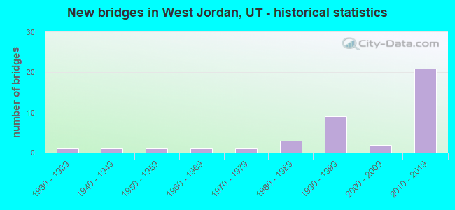
- New bridges - historical statistics
- 11930-1939
- 11940-1949
- 11950-1959
- 11960-1969
- 11970-1979
- 31980-1989
- 91990-1999
- 22000-2009
- 212010-2019
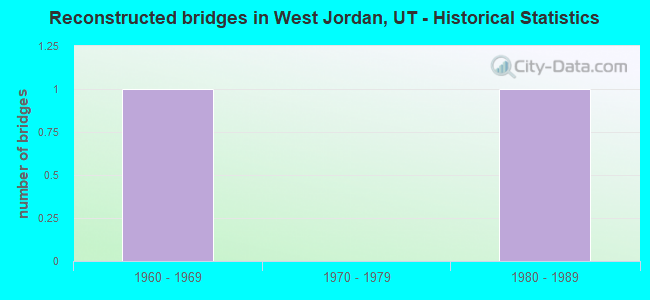
- Reconstructed bridges - Historical Statistics
- 11960-1969
- 01970-1979
- 11980-1989
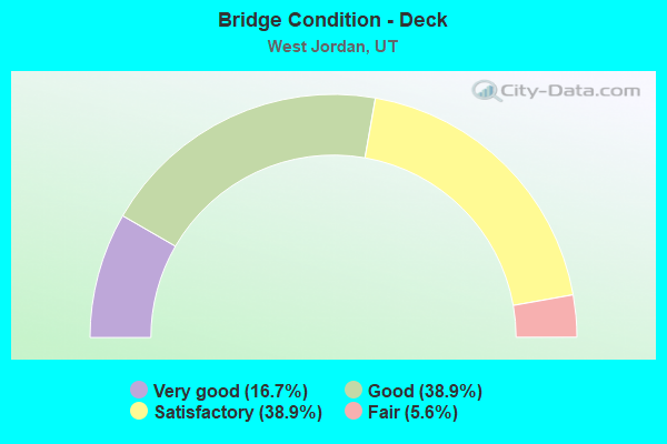
- Bridge Condition - Deck
- 16.7%Very good
- 38.9%Good
- 38.9%Satisfactory
- 5.6%Fair
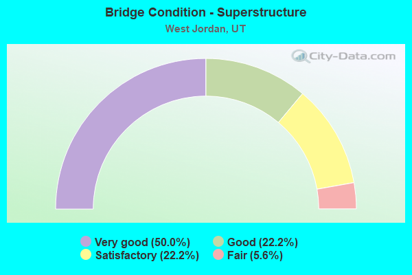
- Bridge Condition - Superstructure
- 50.0%Very good
- 22.2%Good
- 22.2%Satisfactory
- 5.6%Fair
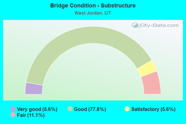
- Bridge Condition - Substructure
- 5.6%Very good
- 77.8%Good
- 5.6%Satisfactory
- 11.1%Fair
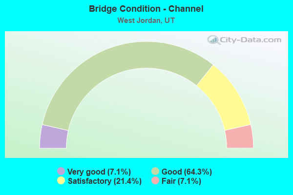
- Bridge Condition - Channel
- 7.1%Very good
- 64.3%Good
- 21.4%Satisfactory
- 7.1%Fair
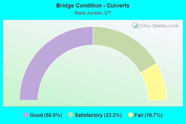
- Bridge Condition - Culverts
- 50.0%Good
- 33.3%Satisfactory
- 16.7%Fair
Find on map >> Show street view
Structure Number: 35021D, Location: 2650 W. 8660 S., W.JORDAN (Lat: 40.594086, Lng: -111.957208), Route carried "on" structure: City street , Year Built: 1981, Status: Posted for load, Structure Length: 0.85m (2.79ft), Average Daily Traffic: 1,323 (year 2020), Truck Traffic: 1%, Average Future Daily Traffic: 1,607 (year 2040), Design Load: HS 20+Mod, Features Intersected: UTAH AND SALT LAKE CANAL, Facility Carried by Structure: 8660 SOUTH STREET
Minimum Vertical Clearance: 30+ m (98+ ft), Kilometerpoint: 0.051, Lanes on structure: 2, Owner: City or Municipal Highway Agency, Approaching Roadway Width: 12.2m (40.0ft), Skew: 1 degrees, Material/Design: Concrete, Design/Construction: Frame, Number Of Spans In Main Unit: 1, Length of Maximum Span: 7.9m (25.9ft), Curb or Sidewalk Widths: Left: 2.1m (6.9ft), Right: 2.1m (6.9ft), Curb-To-Curb Width: 12.2m (40.0ft), Out-to-Out Width: 17.0m (55.8ft)
Condition: Deck: Satisfactory, Superstructure: Satisfactory, Substructure: Good, Channel: Good, Operating Rating: 11.0 metric tons, Method Used To Determine Operating Rating: Load Factor (LF) rating reported by rating factor (RF) method using MS18 loading, Inventory Rating: 9.7 metric tons, Method Used To Determine Inventory Rating: Load Factor (LF) rating reported by rating factor (RF) method using MS18 loading, Structural Evaluation: High priority of corrective action, Deck Geometry: Better than present minimum criteria, Waterway Adequacy: Better than present minimum criteria, Approach Roadway Alignment: Equal to present desirable criteria, Bridge Posting: Required (Relationship of Operating Rating to Maximum Legal Load: > 39.9% below), Designated Inspection Frequency: Every 24 months, Inspection Date: Febuary 2020, Deck Structure Type: Concrete Cast-file-Place, Wearing Surface/Protective System: Wearing Surface: Bituminous, Deck Protection: Epoxy Coated Reinforcing
Find on map >> Show street view
Structure Number: 35022D, Location: 3100 W. 7000 S., W.JORDAN (Lat: 40.624033, Lng: -111.965539), Route carried "on" structure: City street 2104, Year Built: 1986, Status: Open, Structure Length: 0.87m (2.85ft), Average Daily Traffic: 22,137 (year 2020), Average Future Daily Traffic: 27,671 (year 2040), Design Load: HL 93, Features Intersected: UTAH AND SALT LAKE CANAL, Facility Carried by Structure: 7000 SOUTH STREET
Minimum Vertical Clearance: 30+ m (98+ ft), Kilometerpoint: 2.959, Lanes on structure: 4, Owner: City or Municipal Highway Agency, Approaching Roadway Width: 16.8m (55.1ft), Skew: 21 degrees, Material/Design: Concrete, Design/Construction: Slab, Number Of Spans In Main Unit: 1, Length of Maximum Span: 7.9m (25.9ft), Curb or Sidewalk Widths: Left: 1.5m (4.9ft), Right: 1.5m (4.9ft), Curb-To-Curb Width: 16.8m (55.1ft), Out-to-Out Width: 21.2m (69.6ft)
Condition: Deck: Good, Superstructure: Good, Substructure: Good, Channel: Good, Operating Rating: 32.4 metric tons, Method Used To Determine Operating Rating: Load and Resistance Factor Rating (LRFR) rating reported by rating factor(RF) method using HL-93 loadings, Inventory Rating: 20.1 metric tons, Method Used To Determine Inventory Rating: Load Factor (LF) rating reported by rating factor (RF) method using MS18 loading, Structural Evaluation: Somewhat better than minimum adequacy, Deck Geometry: Somewhat better than minimum adequacy, Waterway Adequacy: Better than present minimum criteria, Approach Roadway Alignment: Equal to present desirable criteria, Designated Inspection Frequency: Every 24 months, Inspection Date: Febuary 2020, Deck Structure Type: Concrete Cast-file-Place, Wearing Surface/Protective System: Wearing Surface: Bituminous
Find on map >> Show street view
Structure Number: 35048E, Location: 2500 W.9000 SO.,W.JORDAN (Lat: 40.587739, Lng: -111.954453), Route carried "on" structure: State highway 209, Year Built: 1996, Status: Open, Structure Length: 0.76m (2.49ft), Average Daily Traffic: 33,935 (year 2020), Truck Traffic: 26%, Average Future Daily Traffic: 42,419 (year 2040), Design Load: HS 20+Mod, Features Intersected: UTAH & SALT LAKE CAN, Facility Carried by Structure: 9000 SOUTH STREET
Minimum Vertical Clearance: 30+ m (98+ ft), Kilometerpoint: 14.313, Lanes on structure: 4, Owner: State Highway Agency, Approaching Roadway Width: 26.2m (86.0ft), Skew: 24 degrees, Material/Design: Concrete, Design/Construction: Culvert, Number Of Spans In Main Unit: 1, Length of Maximum Span: 6.3m (20.7ft), Curb or Sidewalk Widths: Left: 2.7m (8.9ft), Right: 2.7m (8.9ft), Curb-To-Curb Width: 26.2m (86.0ft), Out-to-Out Width: 37.5m (123.0ft)
Condition: Channel: Satisfactory, Culverts: Good, Operating Rating: 32.4 metric tons, Method Used To Determine Operating Rating: Load Factor (LF) rating reported by rating factor (RF) method using MS18 loading, Inventory Rating: 20.4 metric tons, Method Used To Determine Inventory Rating: Load Factor (LF) rating reported by rating factor (RF) method using MS18 loading, Structural Evaluation: Somewhat better than minimum adequacy, Deck Geometry: Superior to present desirable criteria, Waterway Adequacy: Better than present minimum criteria, Approach Roadway Alignment: Equal to present desirable criteria, Designated Inspection Frequency: Every 24 months, Inspection Date: December 2020
Find on map >> Show street view
Structure Number: 35054D, Location: 1000 W. 7800 S., W.JORDAN (Lat: 40.609486, Lng: -111.921475), Route carried "on" structure: City street 2105, Year Built: 1966, Status: Open, Structure Length: 2.63m (8.63ft), Average Daily Traffic: 23,168 (year 2020), Average Future Daily Traffic: 28,960 (year 2040), Design Load: HS 20+Mod, Features Intersected: JORDAN RIVER, Facility Carried by Structure: 7800 SOUTH STREET
Minimum Vertical Clearance: 30+ m (98+ ft), Kilometerpoint: 1.481, Lanes on structure: 4, Owner: City or Municipal Highway Agency, Approaching Roadway Width: 16.5m (54.1ft), Skew: 20 degrees, Material/Design: Concrete continuous, Design/Construction: Slab, Number Of Spans In Main Unit: 3, Length of Maximum Span: 11.0m (36.1ft), Curb or Sidewalk Widths: Left: 1.2m (3.9ft), Right: 1.2m (3.9ft), Curb-To-Curb Width: 16.5m (54.1ft), Out-to-Out Width: 22.6m (74.1ft)
Condition: Deck: Fair, Superstructure: Fair, Substructure: Fair, Channel: Fair, Operating Rating: 44.1 metric tons, Method Used To Determine Operating Rating: Load and Resistance Factor Rating (LRFR) rating reported by rating factor(RF) method using HL-93 loadings, Inventory Rating: 30.5 metric tons, Method Used To Determine Inventory Rating: Load Factor (LF) rating reported by rating factor (RF) method using MS18 loading, Structural Evaluation: Somewhat better than minimum adequacy, Deck Geometry: Meets minimum limits, Waterway Adequacy: Equal to present minimum criteria, Approach Roadway Alignment: Equal to present desirable criteria, Designated Inspection Frequency: Every 24 months, Inspection Date: January 2022, Deck Structure Type: Concrete Cast-file-Place, Wearing Surface/Protective System: Wearing Surface: Bituminous
Find on map >> Show street view
Structure Number: 35105V, Location: 8600 S. 2700 W., W.JORDAN (Lat: 40.595367, Lng: -111.957811), Route carried "on" structure: City street 2040, Year Built: 1950, Year Reconstructed: 1989, Status: Open, Structure Length: 0.89m (2.92ft), Average Daily Traffic: 9,232 (year 2020), Average Future Daily Traffic: 11,540 (year 2040), Design Load: HS 20, Features Intersected: UTAH AND SALT LAKE CANAL, Facility Carried by Structure: 2700 WEST STREET
Minimum Vertical Clearance: 30+ m (98+ ft), Kilometerpoint: 14.045, Lanes on structure: 2, Owner: City or Municipal Highway Agency, Approaching Roadway Width: 15.8m (51.8ft), Skew: 4 degrees, Material/Design: Steel, Design/Construction: Culvert, Number Of Spans In Main Unit: 1, Length of Maximum Span: 7.5m (24.6ft), Curb or Sidewalk Widths: Left: 1.8m (5.9ft), Right: 1.8m (5.9ft)
Condition: Channel: Good, Culverts: Fair, Operating Rating: 48.9 metric tons, Method Used To Determine Operating Rating: Load and Resistance Factor Rating (LRFR) rating reported by rating factor(RF) method using HL-93 loadings, Inventory Rating: 35.3 metric tons, Method Used To Determine Inventory Rating: Load and Resistance Factor Rating (LRFR) rating reported by rating factor(RF) method using HL-93 loadings, Structural Evaluation: Somewhat better than minimum adequacy, Waterway Adequacy: Equal to present desirable criteria, Approach Roadway Alignment: Equal to present desirable criteria, Designated Inspection Frequency: Every 24 months, Inspection Date: Febuary 2020
Find on map >> Show street view
Structure Number: 35163E, Location: 1840 W. 9000 SO.-W.JORDAN (Lat: 40.587733, Lng: -111.941753), Route carried "on" structure: State highway 209, Year Built: 1996, Status: Open, Structure Length: 0.69m (2.26ft), Average Daily Traffic: 33,935 (year 2020), Truck Traffic: 26%, Average Future Daily Traffic: 42,419 (year 2040), Design Load: HS 20+Mod, Features Intersected: SOUTH JORDAN CANAL, Facility Carried by Structure: 9000 SOUTH STREET
Minimum Vertical Clearance: 30+ m (98+ ft), Kilometerpoint: 15.388, Lanes on structure: 4, Owner: State Highway Agency, Approaching Roadway Width: 24.7m (81.0ft), Skew: 1 degrees, Material/Design: Concrete, Design/Construction: Culvert, Number Of Spans In Main Unit: 1, Length of Maximum Span: 6.2m (20.3ft), Curb or Sidewalk Widths: Left: 1.2m (3.9ft), Right: 1.2m (3.9ft)
Condition: Channel: Good, Culverts: Good, Operating Rating: 68.4 metric tons, Method Used To Determine Operating Rating: Load Factor (LF) rating reported by rating factor (RF) method using MS18 loading, Inventory Rating: 50.2 metric tons, Method Used To Determine Inventory Rating: Load Factor (LF) rating reported by rating factor (RF) method using MS18 loading, Structural Evaluation: Better than present minimum criteria, Waterway Adequacy: Equal to present desirable criteria, Approach Roadway Alignment: Equal to present desirable criteria, Designated Inspection Frequency: Every 24 months, Inspection Date: December 2020
Find on map >> Show street view
Structure Number: 35179D, Location: 1150 W. 7800 S., W.JORDAN (Lat: 40.608997, Lng: -111.923850), Route carried "on" structure: City street 2105, Year Built: 1934, Year Reconstructed: 1966, Status: Open, Structure Length: 0.67m (2.20ft), Average Daily Traffic: 23,168 (year 2020), Average Future Daily Traffic: 28,960 (year 2040), Design Load: HS 20, Features Intersected: NORTH JORDAN CANAL, Facility Carried by Structure: 7800 SOUTH STREET
Minimum Vertical Clearance: 30+ m (98+ ft), Kilometerpoint: 1.273, Lanes on structure: 4, Owner: City or Municipal Highway Agency, Approaching Roadway Width: 21.9m (71.9ft), Skew: 20 degrees, Material/Design: Concrete, Design/Construction: Frame, Number Of Spans In Main Unit: 1, Length of Maximum Span: 6.1m (20.0ft), Curb or Sidewalk Widths: Left: 0.0m, Right: 1.5m (4.9ft), Curb-To-Curb Width: 21.9m (71.9ft), Out-to-Out Width: 24.6m (80.7ft)
Condition: Deck: Good, Superstructure: Good, Substructure: Good, Channel: Good, Operating Rating: 40.2 metric tons, Method Used To Determine Operating Rating: Load Factor (LF) rating reported by rating factor (RF) method using MS18 loading, Inventory Rating: 23.7 metric tons, Method Used To Determine Inventory Rating: Load Factor (LF) rating reported by rating factor (RF) method using MS18 loading, Structural Evaluation: Somewhat better than minimum adequacy, Deck Geometry: Superior to present desirable criteria, Waterway Adequacy: Equal to present minimum criteria, Approach Roadway Alignment: Equal to present desirable criteria, Designated Inspection Frequency: Every 24 months, Inspection Date: Febuary 2020, Deck Structure Type: Concrete Cast-file-Place, Wearing Surface/Protective System: Wearing Surface: Bituminous
Find on map >> Show street view
Structure Number: 35183D, Location: 6700 S. 2200 W., W.JORDAN (Lat: 40.628200, Lng: -111.948283), Route carried "on" structure: City street 2085, Year Built: 1989, Status: Open, Structure Length: 0.64m (2.10ft), Average Daily Traffic: 1,000 (year 2020), Average Future Daily Traffic: 1,250 (year 2040), Design Load: HS 20+Mod, Features Intersected: CANAL ROAD., Facility Carried by Structure: 2200 WEST STREET
Minimum Vertical Clearance: 30+ m (98+ ft), Kilometerpoint: 9.336, Lanes on structure: 2, Owner: City or Municipal Highway Agency, Approaching Roadway Width: 13.4m (44.0ft), Skew: 1 degrees, Material/Design: Concrete, Design/Construction: Slab, Number Of Spans In Main Unit: 1, Length of Maximum Span: 5.9m (19.4ft), Curb or Sidewalk Widths: Left: 2.7m (8.9ft), Right: 2.7m (8.9ft), Curb-To-Curb Width: 13.4m (44.0ft), Out-to-Out Width: 20.1m (65.9ft)
Condition: Deck: Satisfactory, Superstructure: Satisfactory, Substructure: Good, Channel: Satisfactory, Operating Rating: 44.7 metric tons, Method Used To Determine Operating Rating: Load Factor (LF) rating reported by rating factor (RF) method using MS18 loading, Inventory Rating: 39.5 metric tons, Method Used To Determine Inventory Rating: Load Factor (LF) rating reported by rating factor (RF) method using MS18 loading, Structural Evaluation: Equal to present minimum criteria, Deck Geometry: Superior to present desirable criteria, Waterway Adequacy: Equal to present minimum criteria, Approach Roadway Alignment: Equal to present minimum criteria, Designated Inspection Frequency: Every 24 months, Inspection Date: Febuary 2020, Deck Structure Type: Concrete Cast-file-Place, Wearing Surface/Protective System: Wearing Surface: Bituminous
Find on map >> Show street view
Structure Number: 35210D, Location: 2235 W. 7320 S., W.JORDAN (Lat: 40.618322, Lng: -111.949206), Route carried "on" structure: Alternate City street , Year Built: 2010, Status: Open, Structure Length: 0.63m (2.07ft), Average Daily Traffic: 400 (year 2020), Average Future Daily Traffic: 450 (year 2040), Design Load: HS 20+Mod, Features Intersected: SOUTH JORDAN CANAL, Facility Carried by Structure: HARVEST LN.,7320 S
Minimum Vertical Clearance: 30+ m (98+ ft), Kilometerpoint: 0.072, Lanes on structure: 2, Owner: City or Municipal Highway Agency, Approaching Roadway Width: 13.0m (42.7ft), Material/Design: Concrete, Design/Construction: Slab, Number Of Spans In Main Unit: 1, Length of Maximum Span: 5.9m (19.4ft), Curb or Sidewalk Widths: Left: 1.3m (4.3ft), Right: 1.3m (4.3ft), Curb-To-Curb Width: 13.0m (42.7ft), Out-to-Out Width: 16.3m (53.5ft)
Condition: Deck: Satisfactory, Superstructure: Satisfactory, Substructure: Good, Channel: Good, Operating Rating: 32.4 metric tons, Method Used To Determine Operating Rating: Load and Resistance Factor Rating (LRFR) rating reported by rating factor(RF) method using HL-93 loadings, Inventory Rating: 19.1 metric tons, Method Used To Determine Inventory Rating: Load Factor (LF) rating reported by rating factor (RF) method using MS18 loading, Structural Evaluation: Somewhat better than minimum adequacy, Deck Geometry: Superior to present desirable criteria, Waterway Adequacy: Equal to present desirable criteria, Approach Roadway Alignment: Equal to present desirable criteria, Designated Inspection Frequency: Every 24 months, Inspection Date: Febuary 2020, Deck Structure Type: Concrete Cast-file-Place, Wearing Surface/Protective System: Wearing Surface: Bituminous, Deck Protection: Epoxy Coated Reinforcing
Find on map >> Show street view
Structure Number: C1009, Location: 7800 So.3800 W.,W.Jordan (Lat: 40.609100, Lng: -111.976558), Route carried "on" structure: State highway 154, Year Built: 2012, Status: Open, Structure Length: 5.58m (18.31ft), Average Daily Traffic: 47,707 (year 2020), Truck Traffic: 19%, Average Future Daily Traffic: 59,634 (year 2040), Design Load: HL 93, Features Intersected: SR-48,7800 SO.ST.
Minimum Vertical Clearance: 30+ m (98+ ft), Kilometerpoint: 20.711, Lanes on structure: 6, Lanes under structure: 6, Base Highway Network: Yes, Owner: State Highway Agency, Approaching Roadway Width: 16.2m (53.1ft), Skew: 30 degrees, Material/Design: Steel, Design/Construction: Stringer/Multi-beam, Number Of Spans In Main Unit: 1, Length of Maximum Span: 54.6m (179.1ft), Curb-To-Curb Width: 16.2m (53.1ft), Out-to-Out Width: 34.4m (112.9ft)
Condition: Deck: Good, Superstructure: Very good, Substructure: Satisfactory, Operating Rating: 40.8 metric tons, Method Used To Determine Operating Rating: Load and Resistance Factor Rating (LRFR) rating reported by rating factor(RF) method using HL-93 loadings, Inventory Rating: 28.5 metric tons, Method Used To Determine Inventory Rating: Load and Resistance Factor Rating (LRFR) rating reported by rating factor(RF) method using HL-93 loadings, Structural Evaluation: Equal to present minimum criteria, Deck Geometry: High priority of replacement, Underclear: High priority of corrective action, Approach Roadway Alignment: Equal to present desirable criteria, Designated Inspection Frequency: Every 24 months, Inspection Date: December 2020, Deck Structure Type: Concrete Precast Panels, Wearing Surface/Protective System: Wearing Surface: Epoxy Overlay, Deck Protection: Epoxy Coated Reinforcing
Find on map >> Show street view
Structure Number: C1042, Location: 3800 W 11400 S (Lat: 40.544197, Lng: -111.984150), Route carried "on" structure: State highway 154, Year Built: 2018, Status: Open, Structure Length: 4.25m (13.94ft), Average Daily Traffic: 46,045 (year 2020), Truck Traffic: 22%, Average Future Daily Traffic: 57,556 (year 2040), Design Load: HL 93, Features Intersected: Bangerter Hwy SR-154, Facility Carried by Structure: 11400 South SR-175
Minimum Vertical Clearance: 5.15m (16.90ft), Kilometerpoint: 13.358, Lanes on structure: 6, Lanes under structure: 6, Base Highway Network: Yes, Owner: State Highway Agency, Approaching Roadway Width: 29.2m (95.8ft), Material/Design: Steel, Design/Construction: Stringer/Multi-beam, Number Of Spans In Main Unit: 1, Length of Maximum Span: 41.6m (136.5ft), Curb or Sidewalk Widths: Left: 1.8m (5.9ft), Right: 1.8m (5.9ft), Curb-To-Curb Width: 29.2m (95.8ft), Out-to-Out Width: 71.6m (234.9ft)
Condition: Deck: Good, Superstructure: Very good, Substructure: Good, Operating Rating: 43.4 metric tons, Method Used To Determine Operating Rating: Load and Resistance Factor Rating (LRFR) rating reported by rating factor(RF) method using HL-93 loadings, Inventory Rating: 33.4 metric tons, Method Used To Determine Inventory Rating: Load and Resistance Factor Rating (LRFR) rating reported by rating factor(RF) method using HL-93 loadings, Structural Evaluation: Better than present minimum criteria, Deck Geometry: Better than present minimum criteria, Underclear: Equal to present minimum criteria, Approach Roadway Alignment: Equal to present desirable criteria, Designated Inspection Frequency: Every 24 months, Inspection Date: December 2020, Deck Structure Type: Concrete Cast-file-Place, Wearing Surface/Protective System: Wearing Surface: Epoxy Overlay, Deck Protection: Epoxy Coated Reinforcing
Structure Number: C1043, Location: 6900 S 3600 W, Route carried "on" structure: 154, Year Built: 2018, Structure Length: 8.06m (26.44ft), Average Daily Traffic: 58,433 (year 2020), Truck Traffic: 18%, Average Future Daily Traffic: 73,041 (year 2040), Design Load: Pedestrian, Features Intersected: Bangerter (SR 154), Facility Carried by Structure: Ped Bridge
Kilometerpoint: 22.531, Lanes under structure: 6, Owner: State Highway Agency, Material/Design: Steel, Design/Construction: Truss - Thru, Number Of Spans In Main Unit: 1, Length of Maximum Span: 80.6m (264.4ft), Out-to-Out Width: 2.8m (9.2ft)
Condition: Deck: Satisfactory, Superstructure: Very good, Substructure: Good, Designated Inspection Frequency: Every 24 months, Inspection Date: December 2020, Deck Structure Type: Concrete Cast-file-Place, Wearing Surface/Protective System: Wearing Surface: Monolithic Concrete, Deck Protection: Epoxy Coated Reinforcing
Find on map >> Show street view
Structure Number: E2379, Location: 1.3 MI.W.of REDWOOD RD. (Lat: 40.609486, Lng: -111.963339), Route carried "on" structure: State highway 48, Year Built: 1992, Status: Open, Structure Length: 0.66m (2.17ft), Average Daily Traffic: 29,987 (year 2020), Truck Traffic: 29%, Average Future Daily Traffic: 37,484 (year 2040), Design Load: HS 20+Mod, Features Intersected: UTAH & SALT LAKE CAN
Minimum Vertical Clearance: 30+ m (98+ ft), Kilometerpoint: 1.175, Lanes on structure: 4, Owner: State Highway Agency, Approaching Roadway Width: 25.5m (83.7ft), Material/Design: Concrete, Design/Construction: Culvert, Number Of Spans In Main Unit: 1, Length of Maximum Span: 6.1m (20.0ft), Curb or Sidewalk Widths: Left: 1.8m (5.9ft), Right: 1.8m (5.9ft)
Condition: Channel: Good, Culverts: Good, Operating Rating: 46.3 metric tons, Method Used To Determine Operating Rating: Load and Resistance Factor Rating (LRFR) rating reported by rating factor(RF) method using HL-93 loadings, Inventory Rating: 37.3 metric tons, Method Used To Determine Inventory Rating: Load and Resistance Factor Rating (LRFR) rating reported by rating factor(RF) method using HL-93 loadings, Structural Evaluation: Better than present minimum criteria, Waterway Adequacy: Equal to present desirable criteria, Approach Roadway Alignment: Equal to present desirable criteria, Designated Inspection Frequency: Every 24 months, Inspection Date: December 2020
Find on map >> Show street view
Structure Number: E2381, Location: 9000 SOUTH 900 WEST (Lat: 40.587722, Lng: -111.919011), Route carried "on" structure: State highway 209, Year Built: 1994, Status: Open, Structure Length: 0.70m (2.30ft), Average Daily Traffic: 38,873 (year 2020), Truck Traffic: 20%, Average Future Daily Traffic: 48,591 (year 2040), Design Load: HS 20+Mod, Features Intersected: NORTH JORDAN CANAL
Minimum Vertical Clearance: 30+ m (98+ ft), Kilometerpoint: 17.313, Lanes on structure: 4, Owner: State Highway Agency, Approaching Roadway Width: 25.6m (84.0ft), Skew: 1 degrees, Material/Design: Concrete, Design/Construction: Culvert, Number Of Spans In Main Unit: 1, Length of Maximum Span: 6.1m (20.0ft)
Condition: Channel: Good, Culverts: Satisfactory, Operating Rating: 32.4 metric tons, Method Used To Determine Operating Rating: Load Factor (LF) rating reported by rating factor (RF) method using MS18 loading, Inventory Rating: 32.1 metric tons, Method Used To Determine Inventory Rating: Load Factor (LF) rating reported by rating factor (RF) method using MS18 loading, Structural Evaluation: Equal to present minimum criteria, Waterway Adequacy: Equal to present desirable criteria, Approach Roadway Alignment: Equal to present desirable criteria, Designated Inspection Frequency: Every 24 months, Inspection Date: November 2020
Find on map >> Show street view
Structure Number: E2486, Location: 9300 SOUTH REDWOOD ROAD (Lat: 40.581858, Lng: -111.938683), Route carried "on" structure: State highway 68, Year Built: 2004, Status: Open, Structure Length: 0.61m (2.00ft), Average Daily Traffic: 26,862 (year 2020), Truck Traffic: 19%, Average Future Daily Traffic: 33,578 (year 2040), Design Load: HS 20+Mod, Features Intersected: SOUTH JORDAN CANAL
Minimum Vertical Clearance: 30+ m (98+ ft), Kilometerpoint: 74.807, Lanes on structure: 5, Owner: State Highway Agency, Approaching Roadway Width: 25.2m (82.7ft), Skew: 26 degrees, Material/Design: Concrete, Design/Construction: Culvert, Number Of Spans In Main Unit: 1, Length of Maximum Span: 5.5m (18.0ft), Curb or Sidewalk Widths: Left: 1.8m (5.9ft), Right: 1.8m (5.9ft), Curb-To-Curb Width: 25.1m (82.3ft), Out-to-Out Width: 30.7m (100.7ft)
Condition: Channel: Good, Culverts: Satisfactory, Operating Rating: 42.4 metric tons, Method Used To Determine Operating Rating: Load and Resistance Factor Rating (LRFR) rating reported by rating factor(RF) method using HL-93 loadings, Inventory Rating: 41.5 metric tons, Method Used To Determine Inventory Rating: Load Factor (LF) rating reported by rating factor (RF) method using MS18 loading, Structural Evaluation: Equal to present minimum criteria, Deck Geometry: Superior to present desirable criteria, Waterway Adequacy: Better than present minimum criteria, Approach Roadway Alignment: Equal to present desirable criteria, Designated Inspection Frequency: Every 24 months, Inspection Date: December 2020, Deck Structure Type: Concrete Cast-file-Place, Wearing Surface/Protective System: Wearing Surface: Epoxy Overlay, Deck Protection: Epoxy Coated Reinforcing
Find on map >> Show street view
Structure Number: F 244, Location: 9000 SOUTH 800 WEST (Lat: 40.587739, Lng: -111.912903), Route carried "on" structure: State highway 209, Year Built: 1971, Status: Open, Structure Length: 2.57m (8.43ft), Average Daily Traffic: 38,873 (year 2020), Truck Traffic: 20%, Average Future Daily Traffic: 48,591 (year 2040), Design Load: HS 20+Mod, Features Intersected: JORDAN RIVER
Minimum Vertical Clearance: 30+ m (98+ ft), Kilometerpoint: 17.830, Lanes on structure: 4, Owner: State Highway Agency, Approaching Roadway Width: 18.3m (60.0ft), Skew: 1 degrees, Material/Design: Prestressed concrete, Design/Construction: Stringer/Multi-beam, Number Of Spans In Main Unit: 2, Length of Maximum Span: 12.2m (40.0ft), Curb-To-Curb Width: 19.1m (62.7ft), Out-to-Out Width: 20.1m (65.9ft)
Condition: Deck: Satisfactory, Superstructure: Satisfactory, Substructure: Fair, Channel: Satisfactory, Operating Rating: 33.7 metric tons, Method Used To Determine Operating Rating: Load and Resistance Factor Rating (LRFR) rating reported by rating factor(RF) method using HL-93 loadings, Inventory Rating: 19.1 metric tons, Method Used To Determine Inventory Rating: Load Factor (LF) rating reported by rating factor (RF) method using MS18 loading, Structural Evaluation: Meets minimum limits, Deck Geometry: Equal to present minimum criteria, Waterway Adequacy: Equal to present desirable criteria, Approach Roadway Alignment: Equal to present desirable criteria, Designated Inspection Frequency: Every 24 months, Inspection Date: November 2020, Deck Structure Type: Concrete Cast-file-Place, Wearing Surface/Protective System: Wearing Surface: Monolithic Concrete
Find on map >> Show street view
Structure Number: F 571, Location: 1200 W.7000 S., W. Jordan (Lat: 40.623756, Lng: -111.921125), Route carried "on" structure: State highway 48, Year Built: 1998, Status: Open, Structure Length: 3.25m (10.66ft), Average Daily Traffic: 23,624 (year 2020), Truck Traffic: 15%, Average Future Daily Traffic: 29,530 (year 2040), Design Load: HS 20+Mod, Features Intersected: JORDAN RIVER
Minimum Vertical Clearance: 30+ m (98+ ft), Kilometerpoint: 4.754, Lanes on structure: 4, Owner: State Highway Agency, Approaching Roadway Width: 25.4m (83.3ft), Material/Design: Prestressed concrete, Design/Construction: Stringer/Multi-beam, Number Of Spans In Main Unit: 1, Length of Maximum Span: 31.7m (104.0ft), Curb or Sidewalk Widths: Left: 2.1m (6.9ft), Right: 2.1m (6.9ft), Curb-To-Curb Width: 25.6m (84.0ft), Out-to-Out Width: 30.8m (101.0ft)
Condition: Deck: Satisfactory, Superstructure: Good, Substructure: Good, Channel: Very good, Operating Rating: 71.0 metric tons, Method Used To Determine Operating Rating: Load and Resistance Factor Rating (LRFR) rating reported by rating factor(RF) method using HL-93 loadings, Inventory Rating: 41.8 metric tons, Method Used To Determine Inventory Rating: Load Factor (LF) rating reported by rating factor (RF) method using MS18 loading, Structural Evaluation: Better than present minimum criteria, Deck Geometry: Superior to present desirable criteria, Waterway Adequacy: Equal to present desirable criteria, Approach Roadway Alignment: Equal to present desirable criteria, Designated Inspection Frequency: Every 24 months, Inspection Date: December 2020, Deck Structure Type: Concrete Cast-file-Place, Wearing Surface/Protective System: Wearing Surface: Monolithic Concrete, Deck Protection: Epoxy Coated Reinforcing
Find on map >> Show street view
Structure Number: F 576, Location: 8600 SOUTH 3800 WEST (Lat: 40.593353, Lng: -111.977506), Route carried "on" structure: City street , Year Built: 1994, Status: Open, Structure Length: 4.04m (13.25ft), Average Daily Traffic: 5,000 (year 2020), Average Future Daily Traffic: 7,000 (year 2040), Design Load: HS 20+Mod, Features Intersected: SR-154, (BANGERTER HWY.), Facility Carried by Structure: OLD BINGHAM HWY.
Minimum Vertical Clearance: 30+ m (98+ ft), Kilometerpoint: 0.011, Lanes on structure: 2, Lanes under structure: 6, Owner: State Highway Agency, Approaching Roadway Width: 17.4m (57.1ft), Skew: 2 degrees, Material/Design: Prestressed concrete continuous, Design/Construction: Stringer/Multi-beam, Number Of Spans In Main Unit: 2, Length of Maximum Span: 19.9m (65.3ft), Curb or Sidewalk Widths: Left: 0.0m, Right: 2.1m (6.9ft), Curb-To-Curb Width: 14.3m (46.9ft), Out-to-Out Width: 17.4m (57.1ft)
Condition: Deck: Satisfactory, Superstructure: Very good, Substructure: Good, Operating Rating: 67.1 metric tons, Method Used To Determine Operating Rating: Load and Resistance Factor Rating (LRFR) rating reported by rating factor(RF) method using HL-93 loadings, Inventory Rating: 33.7 metric tons, Method Used To Determine Inventory Rating: Load Factor (LF) rating reported by rating factor (RF) method using MS18 loading, Structural Evaluation: Better than present minimum criteria, Deck Geometry: Superior to present desirable criteria, Underclear: Somewhat better than minimum adequacy, Approach Roadway Alignment: Equal to present desirable criteria, Designated Inspection Frequency: Every 24 months, Inspection Date: December 2020, Deck Structure Type: Concrete Cast-file-Place, Wearing Surface/Protective System: Wearing Surface: Monolithic Concrete, Deck Protection: Epoxy Coated Reinforcing
Find on map >> Show street view
Structure Number: 1C1044, Location: NB Bangtr Hwy over 7000 S (Lat: 40.623992, Lng: -111.976433), Route carried "on" structure: State highway 154, Year Built: 2018, Status: Open, Structure Length: 6.94m (22.77ft), Average Daily Traffic: 6,478 (year 2020), Truck Traffic: 15%, Average Future Daily Traffic: 8,098 (year 2040), Design Load: HL 93, Features Intersected: 7000 S, Facility Carried by Structure: NB Bangerter Hwy
Minimum Vertical Clearance: 5.26m (17.26ft), Kilometerpoint: 207.605, Lanes on structure: 3, Lanes under structure: 6, Base Highway Network: Yes, Owner: State Highway Agency, Approaching Roadway Width: 19.2m (63.0ft), Material/Design: Steel, Design/Construction: Stringer/Multi-beam, Number Of Spans In Main Unit: 1, Length of Maximum Span: 69.4m (227.7ft), Curb-To-Curb Width: 19.2m (63.0ft), Out-to-Out Width: 38.4m (126.0ft)
Condition: Deck: Very good, Superstructure: Very good, Substructure: Good, Operating Rating: 46.3 metric tons, Method Used To Determine Operating Rating: Load and Resistance Factor Rating (LRFR) rating reported by rating factor(RF) method using HL-93 loadings, Inventory Rating: 36.0 metric tons, Method Used To Determine Inventory Rating: Load and Resistance Factor Rating (LRFR) rating reported by rating factor(RF) method using HL-93 loadings, Structural Evaluation: Better than present minimum criteria, Deck Geometry: Superior to present desirable criteria, Underclear: Superior to present desirable criteria, Approach Roadway Alignment: Superior to present desirable criteria, Designated Inspection Frequency: Every 24 months, Inspection Date: December 2020, Deck Structure Type: Concrete Cast-file-Place, Wearing Surface/Protective System: Wearing Surface: Epoxy Overlay, Deck Protection: Epoxy Coated Reinforcing
Find on map >> Show street view
Structure Number: 1C1045, Location: 9000 S and Bangerter (Lat: 40.587475, Lng: -111.273278), Route carried "on" structure: State highway 154, Year Built: 2018, Status: Open, Structure Length: 6.00m (19.69ft), Average Daily Traffic: 47,707 (year 2020), Truck Traffic: 19%, Average Future Daily Traffic: 59,634 (year 2040), Design Load: HL 93, Features Intersected: 9000 S (SR 209), Facility Carried by Structure: NB Bangerter Hwy
Minimum Vertical Clearance: 30+ m (98+ ft), Kilometerpoint: 18.347, Lanes on structure: 3, Lanes under structure: 6, Base Highway Network: Yes, Owner: State Highway Agency, Approaching Roadway Width: 18.3m (60.0ft), Material/Design: Steel, Design/Construction: Stringer/Multi-beam, Number Of Spans In Main Unit: 1, Length of Maximum Span: 60.0m (196.9ft), Curb-To-Curb Width: 18.3m (60.0ft), Out-to-Out Width: 19.2m (63.0ft)
Condition: Deck: Good, Superstructure: Very good, Substructure: Good, Operating Rating: 47.3 metric tons, Method Used To Determine Operating Rating: Load and Resistance Factor Rating (LRFR) rating reported by rating factor(RF) method using HL-93 loadings, Inventory Rating: 36.6 metric tons, Method Used To Determine Inventory Rating: Load and Resistance Factor Rating (LRFR) rating reported by rating factor(RF) method using HL-93 loadings, Structural Evaluation: Better than present minimum criteria, Deck Geometry: Better than present minimum criteria, Underclear: Somewhat better than minimum adequacy, Approach Roadway Alignment: Superior to present desirable criteria, Designated Inspection Frequency: Every 24 months, Inspection Date: December 2020, Deck Structure Type: Concrete Cast-file-Place, Wearing Surface/Protective System: Wearing Surface: Epoxy Overlay, Deck Protection: Epoxy Coated Reinforcing
Find on map >> Show street view
Structure Number: 1F 799, Location: 8200 South & Mt.View (Lat: 40.602075, Lng: -112.029375), Route carried "on" structure: State highway 85, Year Built: 2012, Status: Open, Structure Length: 3.68m (12.07ft), Average Daily Traffic: 12,643 (year 2020), Truck Traffic: 17%, Average Future Daily Traffic: 15,804 (year 2040), Design Load: HL 93, Features Intersected: 8200 SOUTH STREET
Minimum Vertical Clearance: 30+ m (98+ ft), Kilometerpoint: 23.336, Lanes on structure: 2, Lanes under structure: 2, Owner: State Highway Agency, Approaching Roadway Width: 14.6m (47.9ft), Skew: 10 degrees, Material/Design: Prestressed concrete, Design/Construction: Stringer/Multi-beam, Number Of Spans In Main Unit: 1, Length of Maximum Span: 35.5m (116.5ft), Curb-To-Curb Width: 14.6m (47.9ft), Out-to-Out Width: 15.5m (50.9ft)
Condition: Deck: Good, Superstructure: Good, Substructure: Good, Operating Rating: 40.2 metric tons, Method Used To Determine Operating Rating: Load and Resistance Factor Rating (LRFR) rating reported by rating factor(RF) method using HL-93 loadings, Inventory Rating: 29.5 metric tons, Method Used To Determine Inventory Rating: Load and Resistance Factor Rating (LRFR) rating reported by rating factor(RF) method using HL-93 loadings, Structural Evaluation: Better than present minimum criteria, Deck Geometry: Superior to present desirable criteria, Underclear: Equal to present minimum criteria, Approach Roadway Alignment: Equal to present desirable criteria, Designated Inspection Frequency: Every 24 months, Inspection Date: December 2020, Deck Structure Type: Concrete Cast-file-Place, Wearing Surface/Protective System: Wearing Surface: Integral Concrete, Deck Protection: Epoxy Coated Reinforcing
Find on map >> Show street view
Structure Number: 3C1044, Location: Bangerter Hwy over 7000S (Lat: 40.623631, Lng: -111.976347), Route carried "on" structure: State highway 154, Year Built: 2018, Status: Open, Structure Length: 6.94m (22.77ft), Average Daily Traffic: 58,212 (year 2020), Truck Traffic: 18%, Average Future Daily Traffic: 72,765 (year 2040), Design Load: HL 93, Features Intersected: 7000 S, Facility Carried by Structure: SB Bangerter Hwy
Minimum Vertical Clearance: 5.38m (17.65ft), Kilometerpoint: 22.324, Lanes on structure: 3, Lanes under structure: 4, Owner: State Highway Agency, Approaching Roadway Width: 19.2m (63.0ft), Material/Design: Steel, Design/Construction: Stringer/Multi-beam, Number Of Spans In Main Unit: 1, Length of Maximum Span: 69.4m (227.7ft), Curb-To-Curb Width: 19.2m (63.0ft), Out-to-Out Width: 19.2m (63.0ft)
Condition: Deck: Very good, Superstructure: Very good, Substructure: Good, Operating Rating: 46.3 metric tons, Method Used To Determine Operating Rating: Load and Resistance Factor Rating (LRFR) rating reported by rating factor(RF) method using HL-93 loadings, Inventory Rating: 36.0 metric tons, Method Used To Determine Inventory Rating: Load and Resistance Factor Rating (LRFR) rating reported by rating factor(RF) method using HL-93 loadings, Structural Evaluation: Better than present minimum criteria, Deck Geometry: Superior to present desirable criteria, Underclear: Superior to present desirable criteria, Approach Roadway Alignment: Equal to present desirable criteria, Designated Inspection Frequency: Every 24 months, Inspection Date: December 2020, Deck Structure Type: Concrete Cast-file-Place, Wearing Surface/Protective System: Wearing Surface: Epoxy Overlay, Deck Protection: Epoxy Coated Reinforcing
Find on map >> Show street view
Structure Number: 3C1045, Location: 9000 S and Bangerter (Lat: 40.587464, Lng: -111.977411), Route carried "on" structure: State highway 154, Year Built: 2018, Status: Open, Structure Length: 6.00m (19.69ft), Average Daily Traffic: 52,009 (year 2020), Truck Traffic: 20%, Average Future Daily Traffic: 65,011 (year 2040), Design Load: HL 93, Features Intersected: 9000 S (SR 209), Facility Carried by Structure: SB Bangerter Hwy
Minimum Vertical Clearance: 30+ m (98+ ft), Kilometerpoint: 18.304, Lanes on structure: 3, Lanes under structure: 6, Base Highway Network: Yes, Owner: State Highway Agency, Approaching Roadway Width: 18.3m (60.0ft), Material/Design: Steel, Design/Construction: Stringer/Multi-beam, Number Of Spans In Main Unit: 1, Length of Maximum Span: 60.0m (196.9ft), Curb-To-Curb Width: 18.3m (60.0ft), Out-to-Out Width: 19.2m (63.0ft)
Condition: Deck: Very good, Superstructure: Very good, Substructure: Good, Operating Rating: 47.3 metric tons, Method Used To Determine Operating Rating: Load and Resistance Factor Rating (LRFR) rating reported by rating factor(RF) method using HL-93 loadings, Inventory Rating: 36.6 metric tons, Method Used To Determine Inventory Rating: Load and Resistance Factor Rating (LRFR) rating reported by rating factor(RF) method using HL-93 loadings, Structural Evaluation: Better than present minimum criteria, Deck Geometry: Better than present minimum criteria, Underclear: Somewhat better than minimum adequacy, Approach Roadway Alignment: Equal to present minimum criteria, Designated Inspection Frequency: Every 24 months, Inspection Date: December 2020, Deck Structure Type: Concrete Cast-file-Place, Wearing Surface/Protective System: Wearing Surface: Epoxy Overlay, Deck Protection: Epoxy Coated Reinforcing
Find on map >> Show street view
Structure Number: 3F 799, Location: 8200 South & Mt.View (Lat: 40.602458, Lng: -112.030064), Route carried "on" structure: State highway 85, Year Built: 2012, Status: Open, Structure Length: 3.68m (12.07ft), Average Daily Traffic: 28,839 (year 2020), Truck Traffic: 19%, Average Future Daily Traffic: 36,049 (year 2040), Design Load: HL 93, Features Intersected: 8200 SOUTH STREET
Minimum Vertical Clearance: 30+ m (98+ ft), Kilometerpoint: 18.554, Lanes on structure: 2, Lanes under structure: 2, Owner: State Highway Agency, Approaching Roadway Width: 14.6m (47.9ft), Skew: 10 degrees, Material/Design: Prestressed concrete, Design/Construction: Stringer/Multi-beam, Number Of Spans In Main Unit: 1, Length of Maximum Span: 35.5m (116.5ft), Curb-To-Curb Width: 14.6m (47.9ft), Out-to-Out Width: 15.5m (50.9ft)
Condition: Deck: Good, Superstructure: Very good, Substructure: Very good, Operating Rating: 47.3 metric tons, Method Used To Determine Operating Rating: Load and Resistance Factor Rating (LRFR) rating reported by rating factor(RF) method using HL-93 loadings, Inventory Rating: 30.1 metric tons, Method Used To Determine Inventory Rating: Load and Resistance Factor Rating (LRFR) rating reported by rating factor(RF) method using HL-93 loadings, Structural Evaluation: Better than present minimum criteria, Deck Geometry: Superior to present desirable criteria, Underclear: Equal to present minimum criteria, Approach Roadway Alignment: Equal to present desirable criteria, Designated Inspection Frequency: Every 24 months, Inspection Date: December 2020, Deck Structure Type: Concrete Cast-file-Place, Wearing Surface/Protective System: Wearing Surface: Epoxy Overlay, Deck Protection: Epoxy Coated Reinforcing
Find on map >> Show street view
Structure Number: C 254, Location: 2.7 MILES N. OF JCT SR-48 (Lat: 40.615372, Lng: -112.054439), Route carried "under" structure: State highway 111, Year Built: 1947, Structure Length: 0. m, Average Daily Traffic: 9,108 (year 2020), Truck Traffic: 37%, Features Intersected: SR-111, Facility Carried by Structure: KENNECOTT RAILROAD
Minimum Vertical Clearance: 4.72m (15.49ft), Kilometerpoint: 4.417, Lanes under structure: 2, Material/Design: Steel, Design/Construction: Stringer/Multi-beam, Length of Maximum Span: 12.8m (42.0ft)
Find on map >> Show street view
Structure Number: C 785, Location: 8600 SOUTH 3800 WEST (Lat: 40.593239, Lng: -111.977156), Route carried "under" structure: State highway 154, Year Built: 1994, Structure Length: 0. m, Average Daily Traffic: 47,707 (year 2020), Truck Traffic: 19%, Features Intersected: SR-154, (BANGERTER HWY.), Facility Carried by Structure: UTA,MID-JORDAN LN.
Minimum Vertical Clearance: 5.84m (19.16ft), Kilometerpoint: 18.946, Lanes under structure: 6, Material/Design: Steel, Design/Construction: Stringer/Multi-beam, Length of Maximum Span: 20.6m (67.6ft)
Find on map >> Show street view
Structure Number: C 927, Location: 7500 SO.REDWOOD ROAD (Lat: 40.614289, Lng: -111.938786), Route carried "under" structure: State highway 68, Year Built: 2003, Structure Length: 0. m, Average Daily Traffic: 43,000 (year 2020), Truck Traffic: 10%, Features Intersected: SR-68,REDWOOD ROAD, Facility Carried by Structure: PEDESTRIAN O'P
Minimum Vertical Clearance: 5.52m (18.11ft), Kilometerpoint: 77.731, Lanes under structure: 7, Material/Design: Steel, Design/Construction: Truss - Thru, Length of Maximum Span: 37.5m (123.0ft)
Find on map >> Show street view
Structure Number: C1009, Location: 7800 So.3800 W.,W.Jordan (Lat: 40.609100, Lng: -111.976558), Route carried "under" structure: State highway 48, Year Built: 2012, Structure Length: 0. m, Average Daily Traffic: 33,663 (year 2020), Truck Traffic: 15%, Features Intersected: SR-48,7800 SO.ST., Facility Carried by Structure: SR-154,BNGRTR.HWY.
Minimum Vertical Clearance: 5.26m (17.26ft), Kilometerpoint: 13.111, Lanes on structure: 6, Lanes under structure: 6, Material/Design: Steel, Design/Construction: Stringer/Multi-beam, Length of Maximum Span: 54.6m (179.1ft)
Find on map >> Show street view
Structure Number: C101, Location: South of 7800 So. Intchg. (Lat: 40.606558, Lng: -111.976497), Route carried "under" structure: State highway 154, Year Built: 2012, Structure Length: 0. m, Average Daily Traffic: 47,707 (year 2020), Truck Traffic: 19%, Features Intersected: SR-154, BANGERTER HWY., Facility Carried by Structure: PEDESTRIAN WALKWAY
Minimum Vertical Clearance: 6.02m (19.75ft), Kilometerpoint: 20.429, Lanes under structure: 8, Material/Design: Steel, Design/Construction: Truss - Thru, Length of Maximum Span: 39.1m (128.3ft)
Find on map >> Show street view
Structure Number: C1018, Location: 8200 South & SR-111 (Lat: 40.602133, Lng: -112.056850), Route carried "under" structure: State highway 111, Year Built: 2012, Structure Length: 0. m, Average Daily Traffic: 6,799 (year 2020), Truck Traffic: 39%, Features Intersected: SR-111, Facility Carried by Structure: Pedestrian O'p
Minimum Vertical Clearance: 5.65m (18.54ft), Kilometerpoint: 2.934, Lanes under structure: 5, Material/Design: Steel, Design/Construction: Truss - Thru, Length of Maximum Span: 43.9m (144.0ft)
Find on map >> Show street view
Structure Number: C1042, Location: 3800 W 11400 S (Lat: 40.544197, Lng: -111.984150), Route carried "under" structure: State highway 175, Year Built: 2018, Structure Length: 0. m, Average Daily Traffic: 20,009 (year 2020), Truck Traffic: 29%, Features Intersected: Bangerter Hwy SR-154
Minimum Vertical Clearance: 5.15m (16.90ft), Kilometerpoint: 13.358, Lanes on structure: 6, Lanes under structure: 6, Material/Design: Steel, Design/Construction: Stringer/Multi-beam, Length of Maximum Span: 41.6m (136.5ft)
Find on map >> Show street view
Structure Number: F 576, Location: 8600 SOUTH 3800 WEST (Lat: 40.593353, Lng: -111.977506), Route carried "under" structure: State highway 154, Year Built: 1994, Structure Length: 0. m, Average Daily Traffic: 47,707 (year 2020), Truck Traffic: 19%, Features Intersected: SR-154, (BANGERTER HWY.), Facility Carried by Structure: OLD BINGHAM HWY.
Minimum Vertical Clearance: 6.53m (21.42ft), Kilometerpoint: 18.953, Lanes on structure: 2, Lanes under structure: 6, Material/Design: Prestressed concrete continuous, Design/Construction: Stringer/Multi-beam, Length of Maximum Span: 19.9m (65.3ft)
Find on map >> Show street view
Structure Number: F 764, Location: Near 8600 So. 3800 W. (Lat: 40.593314, Lng: -111.977153), Route carried "under" structure: State highway 154, Year Built: 2010, Structure Length: 0. m, Average Daily Traffic: 47,707 (year 2020), Truck Traffic: 19%, Features Intersected: SR-154,(BANGERTER HWY.), Facility Carried by Structure: UTA,MID-JORDAN LN.
Minimum Vertical Clearance: 5.93m (19.46ft), Kilometerpoint: 18.954, Lanes under structure: 6, Material/Design: Prestressed concrete, Design/Construction: Box Beam or Girders - Multiple, Length of Maximum Span: 23.9m (78.4ft)
Find on map >> Show street view
Structure Number: R 288, Location: 8600 SOUTH 3800 WEST (Lat: 40.592947, Lng: -111.977164), Route carried "under" structure: State highway 154, Year Built: 1994, Structure Length: 0. m, Average Daily Traffic: 47,707 (year 2020), Truck Traffic: 19%, Features Intersected: SR-154,BANGERTER HWY., Facility Carried by Structure: DIST. CANAL FLUME
Minimum Vertical Clearance: 5.08m (16.67ft), Kilometerpoint: 18.914, Lanes under structure: 6, Material/Design: Concrete continuous, Design/Construction: Box Beam or Girders - Single/Spread, Length of Maximum Span: 19.5m (64.0ft)
Find on map >> Show street view
Structure Number: 1C1044, Location: NB Bangtr Hwy over 7000 S (Lat: 40.623992, Lng: -111.976433), Route carried "under" structure: City street 2104, Year Built: 2018, Structure Length: 0. m, Average Daily Traffic: 15,426 (year 2020), Features Intersected: 7000 S, Facility Carried by Structure: NB Bangerter Hwy
Minimum Vertical Clearance: 5.39m (17.68ft), Kilometerpoint: 0.000, Lanes on structure: 3, Lanes under structure: 4, Material/Design: Steel, Design/Construction: Stringer/Multi-beam, Length of Maximum Span: 69.4m (227.7ft)
Find on map >> Show street view
Structure Number: 1C1045, Location: 9000 S and Bangerter (Lat: 40.587475, Lng: -111.273278), Route carried "under" structure: State highway 209, Year Built: 2018, Structure Length: 0. m, Average Daily Traffic: 19,851 (year 2020), Truck Traffic: 34%, Features Intersected: 9000 S (SR 209), Facility Carried by Structure: NB Bangerter Hwy
Minimum Vertical Clearance: 5.15m (16.90ft), Kilometerpoint: 12.311, Lanes on structure: 3, Lanes under structure: 6, Material/Design: Steel, Design/Construction: Stringer/Multi-beam, Length of Maximum Span: 60.0m (196.9ft)
Find on map >> Show street view
Structure Number: 1F 799, Location: 8200 South & Mt.View (Lat: 40.602075, Lng: -112.029375), Route carried "under" structure: County highway 2097, Year Built: 2012, Structure Length: 0. m, Average Daily Traffic: 1,000 (year 2020), Features Intersected: 8200 SOUTH STREET, Facility Carried by Structure: SR-85 NB, (MVC)
Minimum Vertical Clearance: 6.98m (22.90ft), Kilometerpoint: 0.000, Lanes on structure: 2, Lanes under structure: 2, Material/Design: Prestressed concrete, Design/Construction: Stringer/Multi-beam, Length of Maximum Span: 35.5m (116.5ft)
Find on map >> Show street view
Structure Number: 3C1044, Location: Bangerter Hwy over 7000S (Lat: 40.623631, Lng: -111.976347), Route carried "under" structure: City street 2104, Year Built: 2018, Structure Length: 0. m, Average Daily Traffic: 15,426 (year 2020), Features Intersected: 7000 S, Facility Carried by Structure: SB Bangerter Hwy
Minimum Vertical Clearance: 5.39m (17.68ft), Kilometerpoint: 0.000, Lanes on structure: 3, Lanes under structure: 4, Material/Design: Steel, Design/Construction: Stringer/Multi-beam, Length of Maximum Span: 69.4m (227.7ft)
Find on map >> Show street view
Structure Number: 3C1045, Location: 9000 S and Bangerter (Lat: 40.587464, Lng: -111.977411), Route carried "under" structure: State highway 209, Year Built: 2018, Structure Length: 0. m, Average Daily Traffic: 19,851 (year 2020), Truck Traffic: 34%, Features Intersected: 9000 S (SR 209), Facility Carried by Structure: SB Bangerter Hwy
Minimum Vertical Clearance: 5.15m (16.90ft), Kilometerpoint: 12.311, Lanes on structure: 3, Lanes under structure: 6, Material/Design: Steel, Design/Construction: Stringer/Multi-beam, Length of Maximum Span: 60.0m (196.9ft)
Find on map >> Show street view
Structure Number: 3F 799, Location: 8200 South & Mt.View (Lat: 40.602458, Lng: -112.030064), Route carried "under" structure: County highway 2097, Year Built: 2012, Structure Length: 0. m, Average Daily Traffic: 1,000 (year 2020), Features Intersected: 8200 SOUTH STREET, Facility Carried by Structure: SR-85 SB, (MVC)
Minimum Vertical Clearance: 5.13m (16.83ft), Kilometerpoint: 0.000, Lanes on structure: 2, Lanes under structure: 2, Material/Design: Prestressed concrete, Design/Construction: Stringer/Multi-beam, Length of Maximum Span: 35.5m (116.5ft)