Bridge Statistics for West Lafayette, Indiana (IN)
Condition, Traffic, Stress, Structural Evaluation, Project Costs
- National Bridge Inventory (NBI) Statistics
- 44Number of bridges
- 604ft / 184mTotal length
- $10,353,000Total costs
- 302,604Total average daily traffic
- 31,663Total average daily truck traffic
- National Bridge Inventory (NBI) Registered Bridges for West Lafayette
- No street view available for this location
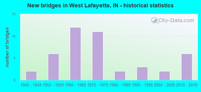
- New bridges - historical statistics
- 21940-1949
- 61950-1959
- 121960-1969
- 111970-1979
- 21980-1989
- 31990-1999
- 22000-2009
- 62010-2019
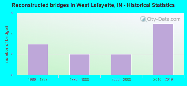
- Reconstructed bridges - Historical Statistics
- 31980-1989
- 21990-1999
- 22000-2009
- 52010-2019
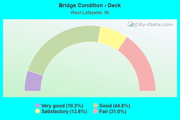
- Bridge Condition - Deck
- 10.3%Very good
- 44.8%Good
- 13.8%Satisfactory
- 31.0%Fair
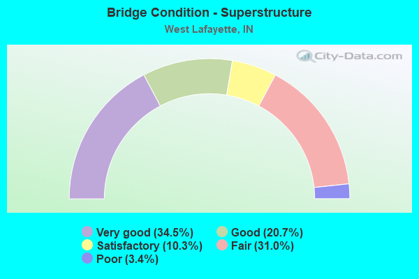
- Bridge Condition - Superstructure
- 34.5%Very good
- 20.7%Good
- 10.3%Satisfactory
- 31.0%Fair
- 3.4%Poor
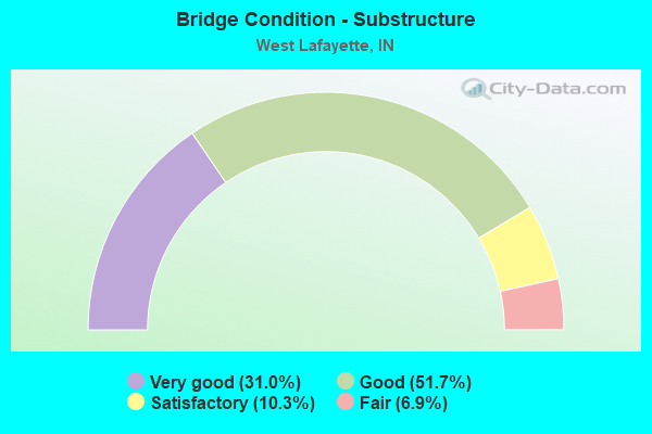
- Bridge Condition - Substructure
- 31.0%Very good
- 51.7%Good
- 10.3%Satisfactory
- 6.9%Fair
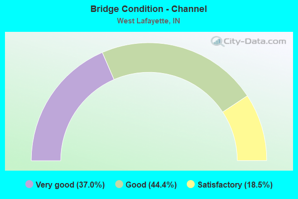
- Bridge Condition - Channel
- 37.0%Very good
- 44.4%Good
- 18.5%Satisfactory
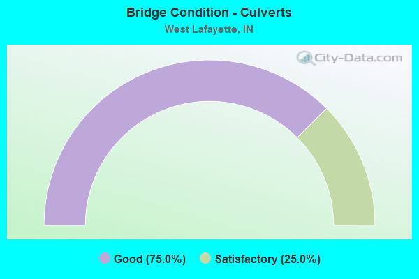
- Bridge Condition - Culverts
- 75.0%Good
- 25.0%Satisfactory
Find on map >> Show street view
Structure Number: 294, Location: 00.40 E SR 49 (Lat: 41.186989, Lng: -87.037461), Route carried "on" structure: State highway 10, Year Built: 2002, Status: Open, Structure Length: 0.91m (2.99ft), Average Daily Traffic: 2,547 (year 2020), Truck Traffic: 11%, Average Future Daily Traffic: 3,577 (year 2030), Design Load: HS 20, Features Intersected: WHEATFIELD DITCH
Minimum Vertical Clearance: 30+ m (98+ ft), Kilometerpoint: 24.687, Lanes on structure: 2, Owner: State Highway Agency, Approaching Roadway Width: 11.9m (39.0ft), Material/Design: Concrete, Design/Construction: Culvert, Number Of Spans In Main Unit: 1, Length of Maximum Span: 8.5m (27.9ft), Curb-To-Curb Width: 12.0m (39.4ft), Out-to-Out Width: 12.0m (39.4ft)
Condition: Channel: Very good, Culverts: Good, Operating Rating: 40.8 metric tons, Method Used To Determine Operating Rating: Field evaluation and documented engineering judgment, Inventory Rating: 32.7 metric tons, Method Used To Determine Inventory Rating: Field evaluation and documented engineering judgment, Structural Evaluation: Better than present minimum criteria, Deck Geometry: Somewhat better than minimum adequacy, Waterway Adequacy: Equal to present desirable criteria, Approach Roadway Alignment: Equal to present desirable criteria, Designated Inspection Frequency: Every 24 months, Inspection Date: January 2022
Find on map >> Show street view
Structure Number: 1622, Location: 00.06 N HAPPY HOLLOW RD (Lat: 40.435131, Lng: -86.897669), Route carried "on" structure: State highway 43, Year Built: 1984, Status: Open, Structure Length: 2.44m (8.01ft), Average Daily Traffic: 7,126 (year 2018), Truck Traffic: 10%, Average Future Daily Traffic: 10,383 (year 2038), Design Load: HS 20, Features Intersected: HAPPY HOLLOW DITCH, Facility Carried by Structure: N RIVER RD
Minimum Vertical Clearance: 30+ m (98+ ft), Kilometerpoint: 0.000, Lanes on structure: 2, Owner: County Highway Agency, Approaching Roadway Width: 14.0m (45.9ft), Material/Design: Concrete continuous, Design/Construction: Slab, Number Of Spans In Main Unit: 3, Length of Maximum Span: 9.8m (32.2ft), Curb-To-Curb Width: 13.4m (44.0ft), Out-to-Out Width: 14.2m (46.6ft)
Condition: Deck: Fair, Superstructure: Fair, Substructure: Satisfactory, Channel: Good, Operating Rating: 50.8 metric tons, Method Used To Determine Operating Rating: Load and Resistance Factor (LRFR), Inventory Rating: 37.7 metric tons, Method Used To Determine Inventory Rating: Load and Resistance Factor (LRFR), Structural Evaluation: Somewhat better than minimum adequacy, Deck Geometry: Equal to present minimum criteria, Waterway Adequacy: Better than present minimum criteria, Approach Roadway Alignment: Equal to present desirable criteria, Length Of Structure Improvement: 2.44m (8.01ft), Designated Inspection Frequency: Every 24 months, Inspection Date: September 2020, Bridge Improvement Cost: $103,000, Roadway Improvement Cost: $91,000, Total Project Cost: $246,000 ( Estimate for 2018), Deck Structure Type: Concrete Cast-file-Place, Wearing Surface/Protective System: Wearing Surface: Monolithic Concrete, Deck Protection: Epoxy Coated Reinforcing
Find on map >> Show street view
Structure Number: 1899, Location: 02.65 W US 231 (Lat: 40.467431, Lng: -86.972811), Route carried "on" structure: US 52, Year Built: 1948, Status: Open, Structure Length: 0.94m (3.08ft), Average Daily Traffic: 10,600 (year 2006), Truck Traffic: 5%, Average Future Daily Traffic: 14,680 (year 2033), Design Load: HS 20, Features Intersected: GAYLORD BRANCH
Minimum Vertical Clearance: 30+ m (98+ ft), Kilometerpoint: 10.895, Lanes on structure: 4, Base Highway Network: Yes (, Subroute: 1), Owner: State Highway Agency, Approaching Roadway Width: 21.0m (68.9ft), Material/Design: Concrete, Design/Construction: Stringer/Multi-beam, Number Of Spans In Main Unit: 1, Length of Maximum Span: 8.5m (27.9ft), Curb-To-Curb Width: 21.0m (68.9ft), Out-to-Out Width: 22.1m (72.5ft)
Condition: Deck: Fair, Superstructure: Fair, Substructure: Fair, Channel: Good, Operating Rating: 64.8 metric tons, Method Used To Determine Operating Rating: Load Factor (LF), Inventory Rating: 38.8 metric tons, Method Used To Determine Inventory Rating: Load Factor (LF), Structural Evaluation: Somewhat better than minimum adequacy, Deck Geometry: Superior to present desirable criteria, Waterway Adequacy: Superior to present desirable criteria, Approach Roadway Alignment: Equal to present desirable criteria, Designated Inspection Frequency: Every 24 months, Inspection Date: December 2020, Deck Structure Type: Concrete Cast-file-Place, Wearing Surface/Protective System: Wearing Surface: Bituminous
Find on map >> Show street view
Structure Number: 19, Location: 02.27 W US 231 (Lat: 40.467381, Lng: -86.965289), Route carried "on" structure: US 52, Year Built: 1948, Status: Open, Structure Length: 1.31m (4.30ft), Average Daily Traffic: 13,013 (year 2004), Truck Traffic: 10%, Average Future Daily Traffic: 18,022 (year 2034), Design Load: HS 20, Features Intersected: INDIAN CREEK
Minimum Vertical Clearance: 30+ m (98+ ft), Kilometerpoint: 11.507, Lanes on structure: 4, Base Highway Network: Yes (, Subroute: 1), Owner: State Highway Agency, Approaching Roadway Width: 21.0m (68.9ft), Skew: 1 degrees, Material/Design: Concrete, Design/Construction: Stringer/Multi-beam, Number Of Spans In Main Unit: 1, Length of Maximum Span: 12.2m (40.0ft), Curb-To-Curb Width: 20.8m (68.2ft), Out-to-Out Width: 21.9m (71.9ft)
Condition: Deck: Fair, Superstructure: Fair, Substructure: Fair, Channel: Good, Operating Rating: 67.8 metric tons, Method Used To Determine Operating Rating: Load Factor (LF), Inventory Rating: 40.8 metric tons, Method Used To Determine Inventory Rating: Load Factor (LF), Structural Evaluation: Somewhat better than minimum adequacy, Deck Geometry: Superior to present desirable criteria, Waterway Adequacy: Better than present minimum criteria, Approach Roadway Alignment: Equal to present desirable criteria, Designated Inspection Frequency: Every 24 months, Inspection Date: December 2020, Deck Structure Type: Concrete Cast-file-Place, Wearing Surface/Protective System: Wearing Surface: Bituminous
Find on map >> Show street view
Structure Number: 1902, Location: 00.46 E SOLDIERS HOME RD (Lat: 40.451711, Lng: -86.894139), Route carried "on" structure: State highway 52, Year Built: 1969, Year Reconstructed: 2019, Status: Open, Structure Length: 30.57m (100.30ft), Average Daily Traffic: 13,410 (year 2015), Truck Traffic: 3%, Average Future Daily Traffic: 16,490 (year 2038), Design Load: HS 20, Features Intersected: WABASH RIVER, N RIVER RD
Minimum Vertical Clearance: 30+ m (98+ ft), Kilometerpoint: 18.202, Lanes on structure: 2, Lanes under structure: 2, Owner: State Highway Agency, Approaching Roadway Width: 12.2m (40.0ft), Material/Design: Steel continuous, Design/Construction: Stringer/Multi-beam, Number Of Spans In Main Unit: 9, Length of Maximum Span: 46.3m (151.9ft), Curb-To-Curb Width: 12.5m (41.0ft), Out-to-Out Width: 13.1m (43.0ft)
Condition: Deck: Satisfactory, Superstructure: Good, Substructure: Satisfactory, Channel: Satisfactory, Operating Rating: 41.1 metric tons, Method Used To Determine Operating Rating: Load and Resistance Factor Rating (LRFR) rating reported by rating factor(RF) method using HL-93 loadings, Inventory Rating: 31.8 metric tons, Method Used To Determine Inventory Rating: Load and Resistance Factor Rating (LRFR) rating reported by rating factor(RF) method using HL-93 loadings, Structural Evaluation: Equal to present minimum criteria, Deck Geometry: Better than present minimum criteria, Underclear: High priority of corrective action, Waterway Adequacy: Superior to present desirable criteria, Approach Roadway Alignment: Equal to present desirable criteria, Designated Inspection Frequency: Every 24 months, Underwater Inspection Frequency: Every 60 months, Other Special Inspection Frequency: Every 48 months, Inspection Date: October 2021, Underwater Inspection Date: November 2019, Other Special Inspection Date: October 2019, Deck Structure Type: Concrete Cast-file-Place, Wearing Surface/Protective System: Wearing Surface: Latex Concrete
Find on map >> Show street view
Structure Number: 294, Location: 00.30 N SR 26 (Lat: 40.425850, Lng: -86.902089), Route carried "on" structure: US , Year Built: 1958, Year Reconstructed: 2015, Status: Open, Structure Length: 5.43m (17.81ft), Average Daily Traffic: 14,336 (year 2013), Truck Traffic: 7%, Average Future Daily Traffic: 23,050 (year 2038), Design Load: HS 20, Features Intersected: N RIVER RD, Facility Carried by Structure: FOWLER AV/WIGGINS
Minimum Vertical Clearance: 30+ m (98+ ft), Kilometerpoint: 24.736, Lanes on structure: 5, Lanes under structure: 4, Owner: County Highway Agency, Approaching Roadway Width: 20.1m (65.9ft), Skew: 10 degrees, Material/Design: Concrete continuous, Design/Construction: Slab, Number Of Spans In Main Unit: 4, Length of Maximum Span: 14.6m (47.9ft), Curb or Sidewalk Widths: Left: 1.5m (4.9ft), Right: 1.7m (5.6ft), Curb-To-Curb Width: 20.2m (66.3ft), Out-to-Out Width: 25.6m (84.0ft)
Condition: Deck: Good, Superstructure: Good, Substructure: Good, Operating Rating: 47.6 metric tons, Method Used To Determine Operating Rating: Load Factor (LF), Inventory Rating: 28.5 metric tons, Method Used To Determine Inventory Rating: Load Factor (LF), Structural Evaluation: Better than present minimum criteria, Deck Geometry: Somewhat better than minimum adequacy, Underclear: Equal to present minimum criteria, Approach Roadway Alignment: Equal to present desirable criteria, Designated Inspection Frequency: Every 24 months, Inspection Date: October 2020, Deck Structure Type: Concrete Cast-file-Place, Wearing Surface/Protective System: Wearing Surface: Latex Concrete
Find on map >> Show street view
Structure Number: 29405, Location: 00.31 S E JCT US 52 (Lat: 40.454069, Lng: -86.928161), Route carried "on" structure: US 231, Year Built: 1976, Year Reconstructed: 2000, Status: Open, Structure Length: 9.42m (30.91ft), Average Daily Traffic: 7,050 (year 2009), Truck Traffic: 3%, Average Future Daily Traffic: 9,934 (year 2031), Design Load: HS 20, Features Intersected: SAGAMORE PKWY EB(OLD 52)
Minimum Vertical Clearance: 30+ m (98+ ft), Kilometerpoint: 28.453, Lanes on structure: 1, Lanes under structure: 2, Owner: State Highway Agency, Approaching Roadway Width: 7.9m (25.9ft), Skew: 6 degrees, Material/Design: Steel, Design/Construction: Stringer/Multi-beam, Number Of Spans In Main Unit: 1, Number Of Approach Spans: 2, Length of Maximum Span: 48.0m (157.5ft), Curb-To-Curb Width: 8.2m (26.9ft), Out-to-Out Width: 9.3m (30.5ft)
Condition: Deck: Good, Superstructure: Satisfactory, Substructure: Good, Operating Rating: 37.9 metric tons, Method Used To Determine Operating Rating: Load and Resistance Factor Rating (LRFR) rating reported by rating factor(RF) method using HL-93 loadings, Inventory Rating: 29.2 metric tons, Method Used To Determine Inventory Rating: Load and Resistance Factor Rating (LRFR) rating reported by rating factor(RF) method using HL-93 loadings, Structural Evaluation: Equal to present minimum criteria, Deck Geometry: High priority of corrective action, Underclear: Equal to present minimum criteria, Approach Roadway Alignment: Equal to present desirable criteria, Designated Inspection Frequency: Every 24 months, Other Special Inspection Frequency: Every 48 months, Inspection Date: April 2021, Other Special Inspection Date: August 2021, Deck Structure Type: Concrete Cast-file-Place, Wearing Surface/Protective System: Wearing Surface: Latex Concrete
Find on map >> Show street view
Structure Number: 32675, Location: 01.35 N RIVER RD/OLD SR43 (Lat: 40.452589, Lng: -86.903089), Route carried "on" structure: State highway 443, Year Built: 1976, Year Reconstructed: 2018, Status: Open, Structure Length: 7.47m (24.51ft), Average Daily Traffic: 13,520 (year 2018), Truck Traffic: 3%, Average Future Daily Traffic: 18,260 (year 2038), Design Load: HS 20, Features Intersected: SAGAMORE PKWY(OLD US 52), Facility Carried by Structure: SOLDIERS HOME RD
Minimum Vertical Clearance: 30+ m (98+ ft), Kilometerpoint: 2.221, Lanes on structure: 2, Lanes under structure: 6, Owner: State Highway Agency, Approaching Roadway Width: 12.0m (39.4ft), Material/Design: Steel continuous, Design/Construction: Stringer/Multi-beam, Number Of Spans In Main Unit: 2, Length of Maximum Span: 36.6m (120.1ft), Curb or Sidewalk Widths: Left: 3.0m (9.8ft), Right: 0.0m, Curb-To-Curb Width: 12.0m (39.4ft), Out-to-Out Width: 15.7m (51.5ft)
Condition: Deck: Good, Superstructure: Good, Substructure: Good, Operating Rating: 41.1 metric tons, Method Used To Determine Operating Rating: Load and Resistance Factor Rating (LRFR) rating reported by rating factor(RF) method using HL-93 loadings, Inventory Rating: 31.8 metric tons, Method Used To Determine Inventory Rating: Load and Resistance Factor Rating (LRFR) rating reported by rating factor(RF) method using HL-93 loadings, Structural Evaluation: Better than present minimum criteria, Deck Geometry: Somewhat better than minimum adequacy, Underclear: Meets minimum limits, Approach Roadway Alignment: Equal to present minimum criteria, Designated Inspection Frequency: Every 24 months, Inspection Date: December 2020, Deck Structure Type: Concrete Cast-file-Place, Wearing Surface/Protective System: Wearing Surface: Monolithic Concrete, Deck Protection: Epoxy Coated Reinforcing
Find on map >> Show street view
Structure Number: 3778, Location: 03.13 N SR 25 (Lat: 40.496961, Lng: -86.868389), Route carried "on" structure: Interstate 65, Year Built: 1968, Year Reconstructed: 1993, Status: Open, Structure Length: 4.27m (14.01ft), Average Daily Traffic: 17,903 (year 2004), Truck Traffic: 10%, Average Future Daily Traffic: 32,423 (year 2034), Design Load: HS 20+Mod, Features Intersected: SR 43
Minimum Vertical Clearance: 30+ m (98+ ft), Kilometerpoint: 286.302, Lanes on structure: 3, Lanes under structure: 4, Base Highway Network: Yes (, Subroute: 1), Owner: State Highway Agency, Approaching Roadway Width: 18.3m (60.0ft), Skew: 2 degrees, Material/Design: Steel continuous, Design/Construction: Stringer/Multi-beam, Number Of Spans In Main Unit: 2, Length of Maximum Span: 21.9m (71.9ft), Curb-To-Curb Width: 17.9m (58.7ft), Out-to-Out Width: 18.9m (62.0ft)
Condition: Deck: Fair, Superstructure: Fair, Substructure: Satisfactory, Operating Rating: 39.9 metric tons, Method Used To Determine Operating Rating: Load and Resistance Factor Rating (LRFR) rating reported by rating factor(RF) method using HL-93 loadings, Inventory Rating: 30.8 metric tons, Method Used To Determine Inventory Rating: Load and Resistance Factor Rating (LRFR) rating reported by rating factor(RF) method using HL-93 loadings, Structural Evaluation: Somewhat better than minimum adequacy, Deck Geometry: Better than present minimum criteria, Underclear: Somewhat better than minimum adequacy, Approach Roadway Alignment: Equal to present desirable criteria, Designated Inspection Frequency: Every 24 months, Other Special Inspection Frequency: Every 60 months, Inspection Date: August 2021, Other Special Inspection Date: June 2020, Deck Structure Type: Concrete Cast-file-Place, Wearing Surface/Protective System: Wearing Surface: Latex Concrete
Find on map >> Show street view
Structure Number: 3783, Location: 02.50 N SR 43 (Lat: 40.522189, Lng: -86.899611), Route carried "on" structure: County highway , Year Built: 1968, Status: Open, Structure Length: 7.50m (24.61ft), Average Daily Traffic: 670 (year 2015), Truck Traffic: 10%, Average Future Daily Traffic: 1,495 (year 2035), Design Load: HS 20, Features Intersected: I-65 SB/NB, Facility Carried by Structure: CR 725N
Minimum Vertical Clearance: 30+ m (98+ ft), Kilometerpoint: 0.000, Lanes on structure: 2, Lanes under structure: 4, Owner: State Highway Agency, Approaching Roadway Width: 6.1m (20.0ft), Skew: 3 degrees, Material/Design: Steel continuous, Design/Construction: Stringer/Multi-beam, Number Of Spans In Main Unit: 2, Length of Maximum Span: 36.7m (120.4ft), Curb or Sidewalk Widths: Left: 0.1m (0.3ft), Right: 0.1m (0.3ft), Curb-To-Curb Width: 9.7m (31.8ft), Out-to-Out Width: 10.6m (34.8ft)
Condition: Deck: Fair, Superstructure: Satisfactory, Substructure: Good, Operating Rating: 40.2 metric tons, Method Used To Determine Operating Rating: Load and Resistance Factor Rating (LRFR) rating reported by rating factor(RF) method using HL-93 loadings, Inventory Rating: 31.1 metric tons, Method Used To Determine Inventory Rating: Load and Resistance Factor Rating (LRFR) rating reported by rating factor(RF) method using HL-93 loadings, Structural Evaluation: Equal to present minimum criteria, Deck Geometry: Equal to present minimum criteria, Underclear: Equal to present minimum criteria, Approach Roadway Alignment: Equal to present desirable criteria, Designated Inspection Frequency: Every 24 months, Inspection Date: August 2021, Deck Structure Type: Concrete Cast-file-Place, Wearing Surface/Protective System: Wearing Surface: Monolithic Concrete
Find on map >> Show street view
Structure Number: 7967, Location: 00.62 N US 52 N JCT (Lat: 40.483581, Lng: -87.029550), Route carried "on" structure: US 231, Year Built: 2014, Status: Open, Structure Length: 2.09m (6.86ft), Average Daily Traffic: 1,890 (year 2014), Truck Traffic: 19%, Average Future Daily Traffic: 2,280 (year 2036), Design Load: HL 93, Features Intersected: LITTLE PINE CREEK
Minimum Vertical Clearance: 30+ m (98+ ft), Kilometerpoint: 0.000, Lanes on structure: 2, Base Highway Network: Yes (, Subroute: 1), Owner: State Highway Agency, Approaching Roadway Width: 11.6m (38.1ft), Skew: 2 degrees, Material/Design: Prestressed concrete, Design/Construction: Stringer/Multi-beam, Number Of Spans In Main Unit: 1, Length of Maximum Span: 20.4m (66.9ft), Curb-To-Curb Width: 11.4m (37.4ft), Out-to-Out Width: 12.3m (40.4ft)
Condition: Deck: Good, Superstructure: Very good, Substructure: Good, Channel: Very good, Operating Rating: 58.0 metric tons, Method Used To Determine Operating Rating: Load and Resistance Factor Rating (LRFR) rating reported by rating factor(RF) method using HL-93 loadings, Inventory Rating: 39.2 metric tons, Method Used To Determine Inventory Rating: Load and Resistance Factor Rating (LRFR) rating reported by rating factor(RF) method using HL-93 loadings, Structural Evaluation: Better than present minimum criteria, Deck Geometry: Equal to present minimum criteria, Waterway Adequacy: Superior to present desirable criteria, Approach Roadway Alignment: Equal to present desirable criteria, Designated Inspection Frequency: Every 24 months, Inspection Date: April 2021, Deck Structure Type: Concrete Cast-file-Place, Wearing Surface/Protective System: Wearing Surface: Monolithic Concrete, Deck Protection: Epoxy Coated Reinforcing
Find on map >> Show street view
Structure Number: 80452, Location: 00.08 S SR 26 (Lat: 40.423031, Lng: -86.939061), Route carried "on" structure: US 52, Year Built: 2012, Status: Open, Structure Length: 3.11m (10.20ft), Average Daily Traffic: 36,070 (year 2005), Truck Traffic: 10%, Average Future Daily Traffic: 48,970 (year 2025), Design Load: HL 93, Features Intersected: UNT WABASH RIVER
Minimum Vertical Clearance: 30+ m (98+ ft), Kilometerpoint: 17.703, Lanes on structure: 6, Base Highway Network: Yes (, Subroute: 1), Owner: State Highway Agency, Approaching Roadway Width: 29.9m (98.1ft), Skew: 2 degrees, Material/Design: Concrete continuous, Design/Construction: Slab, Number Of Spans In Main Unit: 3, Length of Maximum Span: 11.7m (38.4ft), Curb-To-Curb Width: 30.3m (99.4ft), Out-to-Out Width: 31.2m (102.4ft)
Condition: Deck: Good, Superstructure: Good, Substructure: Good, Channel: Very good, Operating Rating: 39.5 metric tons, Method Used To Determine Operating Rating: Load and Resistance Factor Rating (LRFR) rating reported by rating factor(RF) method using HL-93 loadings, Inventory Rating: 30.5 metric tons, Method Used To Determine Inventory Rating: Load and Resistance Factor Rating (LRFR) rating reported by rating factor(RF) method using HL-93 loadings, Structural Evaluation: Better than present minimum criteria, Deck Geometry: Superior to present desirable criteria, Waterway Adequacy: Superior to present desirable criteria, Approach Roadway Alignment: Equal to present desirable criteria, Designated Inspection Frequency: Every 24 months, Inspection Date: December 2020, Deck Structure Type: Concrete Cast-file-Place, Wearing Surface/Protective System: Wearing Surface: Monolithic Concrete, Deck Protection: Epoxy Coated Reinforcing
Find on map >> Show street view
Structure Number: 790007, Location: 00.18 N of Division Rd (Lat: 40.419250, Lng: -86.971119), Route carried "on" structure: County highway 25, Year Built: 1956, Year Reconstructed: 2002, Status: Open, Structure Length: 1.05m (3.44ft), Average Daily Traffic: 249 (year 2018), Truck Traffic: 7%, Average Future Daily Traffic: 363 (year 2038), Features Intersected: JORDAN CREEK, Facility Carried by Structure: CR 350W
Minimum Vertical Clearance: 30+ m (98+ ft), Kilometerpoint: 0.000, Lanes on structure: 2, Owner: County Highway Agency, Approaching Roadway Width: 7.0m (23.0ft), Skew: 3 degrees, Material/Design: Concrete, Design/Construction: Tee Beam, Number Of Spans In Main Unit: 1, Length of Maximum Span: 10.1m (33.1ft), Curb-To-Curb Width: 7.6m (24.9ft), Out-to-Out Width: 8.5m (27.9ft)
Condition: Deck: Good, Superstructure: Very good, Substructure: Good, Channel: Satisfactory, Operating Rating: 43.0 metric tons, Method Used To Determine Operating Rating: Load and Resistance Factor (LRFR), Inventory Rating: 31.9 metric tons, Method Used To Determine Inventory Rating: Load and Resistance Factor (LRFR), Structural Evaluation: Better than present minimum criteria, Deck Geometry: Somewhat better than minimum adequacy, Waterway Adequacy: Superior to present desirable criteria, Approach Roadway Alignment: Equal to present minimum criteria, Designated Inspection Frequency: Every 24 months, Inspection Date: September 2020, Deck Structure Type: Concrete Cast-file-Place, Wearing Surface/Protective System: Wearing Surface: Latex Concrete
Find on map >> Show street view
Structure Number: 7900072, Location: 00.27 S of US 52 (Lat: 40.463619, Lng: -86.980300), Route carried "on" structure: County highway 25, Year Built: 1963, Status: Open, Structure Length: 1.71m (5.61ft), Average Daily Traffic: 2,091 (year 2018), Truck Traffic: 7%, Average Future Daily Traffic: 3,047 (year 2038), Design Load: HS 20, Features Intersected: Indian Creek, Facility Carried by Structure: CR 400W
Minimum Vertical Clearance: 30+ m (98+ ft), Kilometerpoint: 0.000, Lanes on structure: 2, Owner: County Highway Agency, Approaching Roadway Width: 6.4m (21.0ft), Skew: 3 degrees, Material/Design: Prestressed concrete, Design/Construction: Box Beam or Girders - Multiple, Number Of Spans In Main Unit: 1, Length of Maximum Span: 16.5m (54.1ft), Curb or Sidewalk Widths: Left: 0.3m (1.0ft), Right: 0.3m (1.0ft), Curb-To-Curb Width: 7.6m (24.9ft), Out-to-Out Width: 8.8m (28.9ft)
Condition: Deck: Satisfactory, Superstructure: Fair, Substructure: Very good, Channel: Satisfactory, Operating Rating: 47.3 metric tons, Method Used To Determine Operating Rating: Load and Resistance Factor (LRFR), Inventory Rating: 31.2 metric tons, Method Used To Determine Inventory Rating: Load and Resistance Factor (LRFR), Structural Evaluation: Somewhat better than minimum adequacy, Deck Geometry: High priority of replacement, Waterway Adequacy: Superior to present desirable criteria, Approach Roadway Alignment: Equal to present desirable criteria, Designated Inspection Frequency: Every 24 months, Inspection Date: September 2020, Deck Structure Type: Concrete Precast Panels, Wearing Surface/Protective System: Wearing Surface: Bituminous
Find on map >> Show street view
Structure Number: 7900074, Location: 00.05 E of Morehouse Rd (Lat: 40.490000, Lng: -86.954081), Route carried "on" structure: County highway 60, Year Built: 1975, Year Reconstructed: 2010, Status: Open, Structure Length: 1.59m (5.22ft), Average Daily Traffic: 1,809 (year 2016), Truck Traffic: 7%, Average Future Daily Traffic: 2,742 (year 2038), Design Load: HS 20, Features Intersected: Indian Creek, Facility Carried by Structure: CR 500N
Minimum Vertical Clearance: 30+ m (98+ ft), Kilometerpoint: 0.000, Lanes on structure: 2, Owner: County Highway Agency, Approaching Roadway Width: 6.1m (20.0ft), Skew: 1 degrees, Material/Design: Prestressed concrete, Design/Construction: Box Beam or Girders - Multiple, Number Of Spans In Main Unit: 1, Length of Maximum Span: 15.5m (50.9ft), Curb-To-Curb Width: 7.9m (25.9ft), Out-to-Out Width: 8.1m (26.6ft)
Condition: Deck: Good, Superstructure: Very good, Substructure: Very good, Channel: Very good, Operating Rating: 46.4 metric tons, Method Used To Determine Operating Rating: Load and Resistance Factor (LRFR), Inventory Rating: 29.8 metric tons, Method Used To Determine Inventory Rating: Load and Resistance Factor (LRFR), Structural Evaluation: Better than present minimum criteria, Deck Geometry: Meets minimum limits, Waterway Adequacy: Superior to present desirable criteria, Approach Roadway Alignment: Equal to present desirable criteria, Designated Inspection Frequency: Every 48 months, Inspection Date: September 2018, Deck Structure Type: Concrete Cast-file-Place, Wearing Surface/Protective System: Wearing Surface: Latex Concrete
Find on map >> Show street view
Structure Number: 7900075, Location: 00.04 SE of Taft Rd (Lat: 40.489381, Lng: -86.954361), Route carried "on" structure: County highway , Year Built: 1964, Status: Open, Structure Length: 1.52m (4.99ft), Average Daily Traffic: 2,745 (year 2018), Truck Traffic: 7%, Average Future Daily Traffic: 3,999 (year 2038), Design Load: HS 20, Features Intersected: Indian Creek, Facility Carried by Structure: MOREHOUSE RD
Minimum Vertical Clearance: 30+ m (98+ ft), Kilometerpoint: 0.000, Lanes on structure: 2, Owner: County Highway Agency, Approaching Roadway Width: 7.0m (23.0ft), Skew: 2 degrees, Material/Design: Prestressed concrete, Design/Construction: Box Beam or Girders - Multiple, Number Of Spans In Main Unit: 1, Length of Maximum Span: 14.8m (48.6ft), Curb or Sidewalk Widths: Left: 0.3m (1.0ft), Right: 0.3m (1.0ft), Curb-To-Curb Width: 7.6m (24.9ft), Out-to-Out Width: 8.8m (28.9ft)
Condition: Deck: Fair, Superstructure: Fair, Substructure: Good, Channel: Good, Operating Rating: 43.0 metric tons, Method Used To Determine Operating Rating: Load and Resistance Factor (LRFR), Inventory Rating: 25.7 metric tons, Method Used To Determine Inventory Rating: Load and Resistance Factor (LRFR), Structural Evaluation: Somewhat better than minimum adequacy, Deck Geometry: High priority of replacement, Waterway Adequacy: Superior to present desirable criteria, Approach Roadway Alignment: Equal to present desirable criteria, Designated Inspection Frequency: Every 24 months, Inspection Date: September 2020, Deck Structure Type: Concrete Precast Panels, Wearing Surface/Protective System: Wearing Surface: Bituminous
Find on map >> Show street view
Structure Number: 7900076, Location: 00.32 N of US 52 (Lat: 40.471919, Lng: -86.962250), Route carried "on" structure: County highway 29, Year Built: 1964, Status: Open, Structure Length: 1.83m (6.00ft), Average Daily Traffic: 3,398 (year 2018), Truck Traffic: 7%, Average Future Daily Traffic: 4,951 (year 2038), Design Load: HS 20, Features Intersected: Indian Creek, Facility Carried by Structure: CR 300W
Minimum Vertical Clearance: 30+ m (98+ ft), Kilometerpoint: 0.000, Lanes on structure: 2, Owner: County Highway Agency, Approaching Roadway Width: 6.4m (21.0ft), Skew: 1 degrees, Material/Design: Prestressed concrete, Design/Construction: Box Beam or Girders - Multiple, Number Of Spans In Main Unit: 1, Length of Maximum Span: 17.8m (58.4ft), Curb or Sidewalk Widths: Left: 0.3m (1.0ft), Right: 0.3m (1.0ft), Curb-To-Curb Width: 7.6m (24.9ft), Out-to-Out Width: 8.8m (28.9ft)
Condition: Deck: Fair, Superstructure: Fair, Substructure: Very good, Channel: Good, Operating Rating: 38.5 metric tons, Method Used To Determine Operating Rating: Load and Resistance Factor (LRFR), Inventory Rating: 19.0 metric tons, Method Used To Determine Inventory Rating: Load and Resistance Factor (LRFR), Structural Evaluation: Somewhat better than minimum adequacy, Deck Geometry: High priority of replacement, Waterway Adequacy: Superior to present desirable criteria, Approach Roadway Alignment: Equal to present desirable criteria, Length Of Structure Improvement: 1.83m (6.00ft), Designated Inspection Frequency: Every 24 months, Inspection Date: September 2020, Bridge Improvement Cost: $264,000, Roadway Improvement Cost: $112,000, Total Project Cost: $502,000 ( Estimate for 2018), Deck Structure Type: Concrete Precast Panels, Wearing Surface/Protective System: Wearing Surface: Bituminous, Membrane: Preformed Fabric
Find on map >> Show street view
Structure Number: 7900079, Location: 00.63 W of CR 100 W (Lat: 40.540711, Lng: -86.936869), Route carried "on" structure: County highway 74, Year Built: 1973, Status: Open, Structure Length: 1.70m (5.58ft), Average Daily Traffic: 155 (year 2017), Truck Traffic: 7%, Average Future Daily Traffic: 230 (year 2038), Design Load: HS 20, Features Intersected: Burnett Creek, Facility Carried by Structure: CR 850N
Minimum Vertical Clearance: 30+ m (98+ ft), Kilometerpoint: 0.000, Lanes on structure: 2, Owner: County Highway Agency, Approaching Roadway Width: 5.8m (19.0ft), Material/Design: Prestressed concrete, Design/Construction: Box Beam or Girders - Multiple, Number Of Spans In Main Unit: 1, Length of Maximum Span: 16.8m (55.1ft), Curb-To-Curb Width: 7.9m (25.9ft), Out-to-Out Width: 8.0m (26.2ft)
Condition: Deck: Good, Superstructure: Fair, Substructure: Very good, Channel: Good, Operating Rating: 53.4 metric tons, Method Used To Determine Operating Rating: Load and Resistance Factor (LRFR), Inventory Rating: 39.7 metric tons, Method Used To Determine Inventory Rating: Load and Resistance Factor (LRFR), Structural Evaluation: Somewhat better than minimum adequacy, Deck Geometry: Somewhat better than minimum adequacy, Waterway Adequacy: Superior to present desirable criteria, Approach Roadway Alignment: Equal to present desirable criteria, Designated Inspection Frequency: Every 24 months, Inspection Date: September 2020, Deck Structure Type: Concrete Cast-file-Place, Wearing Surface/Protective System: Wearing Surface: Monolithic Concrete
Find on map >> Show street view
Structure Number: 790008, Location: 00.05 W of CR 100 W (Lat: 40.526150, Lng: -86.926061), Route carried "on" structure: County highway 70, Year Built: 1957, Year Reconstructed: 1994, Status: Open, Structure Length: 1.22m (4.00ft), Average Daily Traffic: 349 (year 2018), Truck Traffic: 7%, Average Future Daily Traffic: 508 (year 2038), Design Load: HS 20, Features Intersected: Burnett Creek, Facility Carried by Structure: CR 750N
Minimum Vertical Clearance: 30+ m (98+ ft), Kilometerpoint: 0.000, Lanes on structure: 2, Owner: County Highway Agency, Approaching Roadway Width: 5.5m (18.0ft), Material/Design: Prestressed concrete, Design/Construction: Box Beam or Girders - Multiple, Number Of Spans In Main Unit: 1, Length of Maximum Span: 11.9m (39.0ft), Curb or Sidewalk Widths: Left: 0.2m (0.7ft), Right: 0.2m (0.7ft), Curb-To-Curb Width: 7.5m (24.6ft), Out-to-Out Width: 8.1m (26.6ft)
Condition: Deck: Very good, Superstructure: Poor, Substructure: Good, Channel: Satisfactory, Operating Rating: 50.3 metric tons, Method Used To Determine Operating Rating: Load Factor (LF), Inventory Rating: 28.2 metric tons, Method Used To Determine Inventory Rating: Load Factor (LF), Structural Evaluation: Meets minimum limits, Deck Geometry: Somewhat better than minimum adequacy, Waterway Adequacy: Superior to present desirable criteria, Approach Roadway Alignment: Equal to present desirable criteria, Length Of Structure Improvement: 1.65m (5.41ft), Designated Inspection Frequency: Every 12 months, Inspection Date: September 2021, Bridge Improvement Cost: $261,000, Roadway Improvement Cost: $91,000, Total Project Cost: $507,000 ( Estimate for 2018), Deck Structure Type: Concrete Precast Panels, Wearing Surface/Protective System: Wearing Surface: Bituminous, Membrane: Preformed Fabric
Find on map >> Show street view
Structure Number: 7900081, Location: 00.15 E of Morehouse Rd (Lat: 40.504531, Lng: -86.955139), Route carried "on" structure: County highway 66, Year Built: 1974, Status: Open, Structure Length: 1.52m (4.99ft), Average Daily Traffic: 1,435 (year 2018), Truck Traffic: 7%, Average Future Daily Traffic: 2,091 (year 2038), Design Load: HS 20, Features Intersected: Indian Creek, Facility Carried by Structure: CR 600N
Minimum Vertical Clearance: 30+ m (98+ ft), Kilometerpoint: 0.000, Lanes on structure: 2, Owner: County Highway Agency, Approaching Roadway Width: 6.2m (20.3ft), Skew: 2 degrees, Material/Design: Prestressed concrete, Design/Construction: Box Beam or Girders - Multiple, Number Of Spans In Main Unit: 1, Length of Maximum Span: 14.9m (48.9ft), Curb-To-Curb Width: 7.9m (25.9ft), Out-to-Out Width: 8.0m (26.2ft)
Condition: Deck: Very good, Superstructure: Very good, Substructure: Good, Channel: Satisfactory, Operating Rating: 45.0 metric tons, Method Used To Determine Operating Rating: Load and Resistance Factor (LRFR), Inventory Rating: 25.1 metric tons, Method Used To Determine Inventory Rating: Load and Resistance Factor (LRFR), Structural Evaluation: Equal to present minimum criteria, Deck Geometry: Meets minimum limits, Waterway Adequacy: Superior to present desirable criteria, Approach Roadway Alignment: Equal to present desirable criteria, Designated Inspection Frequency: Every 48 months, Inspection Date: September 2018, Deck Structure Type: Concrete Cast-file-Place, Wearing Surface/Protective System: Wearing Surface: Bituminous
Find on map >> Show street view
Structure Number: 7900083, Location: 00.44 SW SWISHER RD (Lat: 40.476061, Lng: -86.869319), Route carried "on" structure: County highway , Year Built: 1973, Year Reconstructed: 2010, Status: Open, Structure Length: 34.76m (114.04ft), Average Daily Traffic: 7,894 (year 2018), Truck Traffic: 7%, Average Future Daily Traffic: 11,502 (year 2038), Design Load: HS 20, Features Intersected: 2 RDS, WABASH R, Facility Carried by Structure: N 9TH ST
Minimum Vertical Clearance: 30+ m (98+ ft), Kilometerpoint: 0.000, Lanes on structure: 2, Lanes under structure: 2, Owner: County Highway Agency, Approaching Roadway Width: 7.3m (24.0ft), Material/Design: Steel continuous, Design/Construction: Girder and Floorbeam System, Number Of Spans In Main Unit: 5, Number Of Approach Spans: 5, Length of Maximum Span: 48.8m (160.1ft), Curb or Sidewalk Widths: Left: 0.1m (0.3ft), Right: 0.1m (0.3ft), Curb-To-Curb Width: 9.8m (32.2ft), Out-to-Out Width: 10.7m (35.1ft)
Condition: Deck: Satisfactory, Superstructure: Good, Substructure: Good, Channel: Good, Operating Rating: 56.8 metric tons, Method Used To Determine Operating Rating: Load and Resistance Factor (LRFR), Inventory Rating: 56.2 metric tons, Method Used To Determine Inventory Rating: Load and Resistance Factor (LRFR), Structural Evaluation: Better than present minimum criteria, Deck Geometry: Meets minimum limits, Underclear: High priority of corrective action, Waterway Adequacy: Superior to present desirable criteria, Approach Roadway Alignment: Equal to present desirable criteria, Length Of Structure Improvement: 34.76m (114.04ft), Designated Inspection Frequency: Every 24 months, Underwater Inspection Frequency: Every 60 months, Other Special Inspection Frequency: Every 24 months, Inspection Date: September 2020, Underwater Inspection Date: September 2019, Other Special Inspection Date: October 2020, Bridge Improvement Cost: $6,600,000, Roadway Improvement Cost: $600,000, Total Project Cost: $9,000,000 ( Estimate for 2020), Deck Structure Type: Concrete Cast-file-Place, Wearing Surface/Protective System: Wearing Surface: Epoxy Overlay
Find on map >> Show street view
Structure Number: 7900113, Location: 00.37 S of CR 600 N (Lat: 40.498619, Lng: -86.892150), Route carried "on" structure: County highway 45, Year Built: 1980, Status: Open, Structure Length: 2.48m (8.14ft), Average Daily Traffic: 989 (year 2018), Truck Traffic: 7%, Average Future Daily Traffic: 1,441 (year 2038), Design Load: HS 20, Features Intersected: Burnett Creek, Facility Carried by Structure: CR 75E
Minimum Vertical Clearance: 30+ m (98+ ft), Kilometerpoint: 0.000, Lanes on structure: 2, Owner: County Highway Agency, Approaching Roadway Width: 5.8m (19.0ft), Skew: 1 degrees, Material/Design: Prestressed concrete, Design/Construction: Stringer/Multi-beam, Number Of Spans In Main Unit: 1, Length of Maximum Span: 23.9m (78.4ft), Curb-To-Curb Width: 7.3m (24.0ft), Out-to-Out Width: 7.3m (24.0ft)
Condition: Deck: Fair, Superstructure: Good, Substructure: Very good, Channel: Very good, Operating Rating: 69.1 metric tons, Method Used To Determine Operating Rating: Load and Resistance Factor (LRFR), Inventory Rating: 34.5 metric tons, Method Used To Determine Inventory Rating: Load and Resistance Factor (LRFR), Structural Evaluation: Better than present minimum criteria, Deck Geometry: Meets minimum limits, Waterway Adequacy: Superior to present desirable criteria, Approach Roadway Alignment: Equal to present minimum criteria, Length Of Structure Improvement: 2.48m (8.14ft), Designated Inspection Frequency: Every 24 months, Inspection Date: September 2020, Bridge Improvement Cost: $42,000, Roadway Improvement Cost: $29,000, Total Project Cost: $98,000 ( Estimate for 2018), Deck Structure Type: Concrete Cast-file-Place, Wearing Surface/Protective System: Wearing Surface: Monolithic Concrete
Find on map >> Show street view
Structure Number: 7900114, Location: 00.34 S of CR 725 N (Lat: 40.517361, Lng: -86.916219), Route carried "on" structure: County highway 37, Year Built: 1957, Status: Open, Structure Length: 1.30m (4.27ft), Average Daily Traffic: 1,630 (year 2016), Truck Traffic: 7%, Average Future Daily Traffic: 2,471 (year 2038), Design Load: HS 20, Features Intersected: BURNETT CREEK, Facility Carried by Structure: CR 50W
Minimum Vertical Clearance: 30+ m (98+ ft), Kilometerpoint: 0.000, Lanes on structure: 2, Owner: County Highway Agency, Approaching Roadway Width: 6.4m (21.0ft), Material/Design: Concrete, Design/Construction: Tee Beam, Number Of Spans In Main Unit: 1, Length of Maximum Span: 12.5m (41.0ft), Curb or Sidewalk Widths: Left: 0.6m (2.0ft), Right: 0.6m (2.0ft), Curb-To-Curb Width: 7.3m (24.0ft), Out-to-Out Width: 9.1m (29.9ft)
Condition: Deck: Good, Superstructure: Satisfactory, Substructure: Good, Channel: Very good, Operating Rating: 56.9 metric tons, Method Used To Determine Operating Rating: Load and Resistance Factor (LRFR), Inventory Rating: 42.2 metric tons, Method Used To Determine Inventory Rating: Load and Resistance Factor (LRFR), Structural Evaluation: Equal to present minimum criteria, Deck Geometry: Meets minimum limits, Waterway Adequacy: Superior to present desirable criteria, Approach Roadway Alignment: Equal to present desirable criteria, Designated Inspection Frequency: Every 48 months, Inspection Date: September 2018, Deck Structure Type: Concrete Cast-file-Place, Wearing Surface/Protective System: Wearing Surface: Bituminous
Find on map >> Show street view
Structure Number: 7900115, Location: 00.51 E of CR 50 W (Lat: 40.504169, Lng: -86.906381), Route carried "on" structure: County highway 66, Year Built: 1961, Year Reconstructed: 1994, Status: Open, Structure Length: 1.77m (5.81ft), Average Daily Traffic: 4,435 (year 2016), Truck Traffic: 7%, Average Future Daily Traffic: 6,723 (year 2038), Design Load: HS 20, Features Intersected: Burnett Creek, Facility Carried by Structure: CR 600N
Minimum Vertical Clearance: 30+ m (98+ ft), Kilometerpoint: 0.000, Lanes on structure: 2, Owner: County Highway Agency, Approaching Roadway Width: 7.9m (25.9ft), Material/Design: Prestressed concrete, Design/Construction: Stringer/Multi-beam, Number Of Spans In Main Unit: 1, Length of Maximum Span: 16.5m (54.1ft), Curb or Sidewalk Widths: Left: 0.3m (1.0ft), Right: 0.3m (1.0ft), Curb-To-Curb Width: 7.3m (24.0ft), Out-to-Out Width: 8.4m (27.6ft)
Condition: Deck: Satisfactory, Superstructure: Very good, Substructure: Good, Channel: Good, Operating Rating: 71.3 metric tons, Method Used To Determine Operating Rating: Load and Resistance Factor (LRFR), Inventory Rating: 45.7 metric tons, Method Used To Determine Inventory Rating: Load and Resistance Factor (LRFR), Structural Evaluation: Better than present minimum criteria, Deck Geometry: High priority of replacement, Waterway Adequacy: Superior to present desirable criteria, Approach Roadway Alignment: Equal to present desirable criteria, Designated Inspection Frequency: Every 48 months, Inspection Date: September 2018, Deck Structure Type: Concrete Cast-file-Place, Wearing Surface/Protective System: Wearing Surface: Latex Concrete
Find on map >> Show street view
Structure Number: 7900117, Location: 00.25 E of CR 50 W (Lat: 40.511389, Lng: -86.911481), Route carried "on" structure: County highway 45, Year Built: 1960, Year Reconstructed: 2008, Status: Open, Structure Length: 1.65m (5.41ft), Average Daily Traffic: 301 (year 2018), Truck Traffic: 7%, Average Future Daily Traffic: 439 (year 2038), Design Load: HS 20, Features Intersected: Burnett Creek, Facility Carried by Structure: CR 650N
Minimum Vertical Clearance: 30+ m (98+ ft), Kilometerpoint: 0.000, Lanes on structure: 2, Owner: County Highway Agency, Approaching Roadway Width: 5.8m (19.0ft), Material/Design: Prestressed concrete, Design/Construction: Box Beam or Girders - Multiple, Number Of Spans In Main Unit: 1, Length of Maximum Span: 16.2m (53.1ft), Curb-To-Curb Width: 8.1m (26.6ft), Out-to-Out Width: 8.3m (27.2ft)
Condition: Deck: Good, Superstructure: Very good, Substructure: Very good, Channel: Good, Operating Rating: 66.5 metric tons, Method Used To Determine Operating Rating: Load and Resistance Factor (LRFR), Inventory Rating: 40.9 metric tons, Method Used To Determine Inventory Rating: Load and Resistance Factor (LRFR), Structural Evaluation: Equal to present desirable criteria, Deck Geometry: Somewhat better than minimum adequacy, Waterway Adequacy: Superior to present desirable criteria, Approach Roadway Alignment: Equal to present desirable criteria, Designated Inspection Frequency: Every 48 months, Inspection Date: September 2018, Deck Structure Type: Concrete Cast-file-Place, Wearing Surface/Protective System: Wearing Surface: Monolithic Concrete, Deck Protection: Epoxy Coated Reinforcing
Find on map >> Show street view
Structure Number: 7900123, Location: 00.28 W of CR 50 W (Lat: 40.489500, Lng: -86.921219), Route carried "on" structure: County highway 60, Year Built: 1975, Status: Open, Structure Length: 1.41m (4.63ft), Average Daily Traffic: 2,073 (year 2016), Truck Traffic: 7%, Average Future Daily Traffic: 3,143 (year 2038), Design Load: HS 20, Features Intersected: Branch of Burnett Creek, Facility Carried by Structure: CR 500N
Minimum Vertical Clearance: 30+ m (98+ ft), Kilometerpoint: 0.000, Lanes on structure: 2, Owner: County Highway Agency, Approaching Roadway Width: 6.4m (21.0ft), Skew: 1 degrees, Material/Design: Prestressed concrete, Design/Construction: Box Beam or Girders - Multiple, Number Of Spans In Main Unit: 1, Length of Maximum Span: 13.7m (44.9ft), Curb-To-Curb Width: 7.9m (25.9ft), Out-to-Out Width: 8.0m (26.2ft)
Condition: Deck: Very good, Superstructure: Very good, Substructure: Good, Channel: Good, Operating Rating: 48.3 metric tons, Method Used To Determine Operating Rating: Load and Resistance Factor (LRFR), Inventory Rating: 30.8 metric tons, Method Used To Determine Inventory Rating: Load and Resistance Factor (LRFR), Structural Evaluation: Better than present minimum criteria, Deck Geometry: High priority of corrective action, Waterway Adequacy: Superior to present desirable criteria, Approach Roadway Alignment: Equal to present minimum criteria, Designated Inspection Frequency: Every 48 months, Inspection Date: September 2018, Deck Structure Type: Concrete Cast-file-Place, Wearing Surface/Protective System: Wearing Surface: Bituminous
Find on map >> Show street view
Structure Number: 7900155, Location: 00.05 S of US 52 (Lat: 40.466669, Lng: -86.971219), Route carried "on" structure: County highway 655, Year Built: 1961, Year Reconstructed: 2003, Status: Open, Structure Length: 1.22m (4.00ft), Average Daily Traffic: 1,871 (year 2017), Truck Traffic: 7%, Average Future Daily Traffic: 2,780 (year 2038), Design Load: HS 20, Features Intersected: Indian Creek, Facility Carried by Structure: CR 350W/Kerfoot Dr
Minimum Vertical Clearance: 30+ m (98+ ft), Kilometerpoint: 0.000, Lanes on structure: 2, Owner: County Highway Agency, Approaching Roadway Width: 7.9m (25.9ft), Material/Design: Prestressed concrete, Design/Construction: Box Beam or Girders - Multiple, Number Of Spans In Main Unit: 1, Length of Maximum Span: 11.9m (39.0ft), Curb-To-Curb Width: 9.0m (29.5ft), Out-to-Out Width: 9.1m (29.9ft)
Condition: Deck: Fair, Superstructure: Fair, Substructure: Very good, Channel: Good, Operating Rating: 85.2 metric tons, Method Used To Determine Operating Rating: Load Factor (LF), Inventory Rating: 37.7 metric tons, Method Used To Determine Inventory Rating: Load Factor (LF), Structural Evaluation: Somewhat better than minimum adequacy, Deck Geometry: Somewhat better than minimum adequacy, Waterway Adequacy: Superior to present desirable criteria, Approach Roadway Alignment: Equal to present desirable criteria, Designated Inspection Frequency: Every 24 months, Inspection Date: September 2020, Deck Structure Type: Concrete Cast-file-Place, Wearing Surface/Protective System: Wearing Surface: Monolithic Concrete, Deck Protection: Epoxy Coated Reinforcing
Find on map >> Show street view
Structure Number: 7900174, Location: 00.37 W of Soldiers Home (Lat: 40.468831, Lng: -86.906631), Route carried "on" structure: City street , Year Built: 1991, Status: Open, Structure Length: 1.29m (4.23ft), Average Daily Traffic: 3,639 (year 2007), Truck Traffic: 7%, Average Future Daily Traffic: 6,590 (year 2038), Features Intersected: BRANCH OF BURNETT CREEK, Facility Carried by Structure: KALBERER RD
Minimum Vertical Clearance: 30+ m (98+ ft), Kilometerpoint: 0.000, Lanes on structure: 2, Owner: County Highway Agency, Approaching Roadway Width: 14.0m (45.9ft), Skew: 3 degrees, Material/Design: Concrete, Design/Construction: Culvert, Number Of Spans In Main Unit: 4, Length of Maximum Span: 2.8m (9.2ft), Curb or Sidewalk Widths: Left: 5.1m (16.7ft), Right: 5.0m (16.4ft)
Condition: Channel: Very good, Culverts: Satisfactory, Operating Rating: 32.7 metric tons, Method Used To Determine Operating Rating: Field evaluation and documented engineering judgment, Inventory Rating: 32.7 metric tons, Method Used To Determine Inventory Rating: Field evaluation and documented engineering judgment, Structural Evaluation: Equal to present minimum criteria, Waterway Adequacy: Superior to present desirable criteria, Approach Roadway Alignment: Equal to present desirable criteria, Designated Inspection Frequency: Every 24 months, Inspection Date: September 2020
Find on map >> Show street view
Structure Number: 7900208, Location: 00.02 W of CR 250 W (Lat: 40.526311, Lng: -86.953769), Route carried "on" structure: County highway 70, Year Built: 2007, Status: Open, Structure Length: 1.49m (4.89ft), Average Daily Traffic: 88 (year 2018), Truck Traffic: 7%, Average Future Daily Traffic: 128 (year 2038), Design Load: HS 20, Features Intersected: Jakes Ditch, Facility Carried by Structure: CR 750N
Minimum Vertical Clearance: 30+ m (98+ ft), Kilometerpoint: 0.000, Lanes on structure: 2, Owner: County Highway Agency, Approaching Roadway Width: 6.1m (20.0ft), Material/Design: Prestressed concrete, Design/Construction: Box Beam or Girders - Multiple, Number Of Spans In Main Unit: 1, Length of Maximum Span: 14.3m (46.9ft), Curb-To-Curb Width: 8.6m (28.2ft), Out-to-Out Width: 8.7m (28.5ft)
Condition: Deck: Good, Superstructure: Very good, Substructure: Very good, Channel: Very good, Operating Rating: 92.4 metric tons, Method Used To Determine Operating Rating: Load Factor (LF), Inventory Rating: 50.7 metric tons, Method Used To Determine Inventory Rating: Load Factor (LF), Structural Evaluation: Equal to present desirable criteria, Deck Geometry: Better than present minimum criteria, Waterway Adequacy: Superior to present desirable criteria, Approach Roadway Alignment: Equal to present desirable criteria, Designated Inspection Frequency: Every 48 months, Inspection Date: September 2018, Deck Structure Type: Concrete Cast-file-Place, Wearing Surface/Protective System: Wearing Surface: Monolithic Concrete, Deck Protection: Epoxy Coated Reinforcing
Find on map >> Show street view
Structure Number: 7900213, Location: 00.47 S of CR 500 N (Lat: 40.482781, Lng: -86.915769), Route carried "on" structure: County highway 37, Year Built: 1996, Status: Open, Structure Length: 0.75m (2.46ft), Average Daily Traffic: 6,945 (year 2018), Truck Traffic: 7%, Average Future Daily Traffic: 10,119 (year 2038), Features Intersected: Branch of Burnett Creek, Facility Carried by Structure: CR 50W
Minimum Vertical Clearance: 30+ m (98+ ft), Kilometerpoint: 0.000, Lanes on structure: 2, Owner: County Highway Agency, Approaching Roadway Width: 11.0m (36.1ft), Skew: 4 degrees, Material/Design: Concrete, Design/Construction: Culvert, Number Of Spans In Main Unit: 2, Length of Maximum Span: 3.4m (11.2ft)
Condition: Channel: Good, Culverts: Good, Operating Rating: 32.7 metric tons, Method Used To Determine Operating Rating: Field evaluation and documented engineering judgment, Inventory Rating: 32.7 metric tons, Method Used To Determine Inventory Rating: Field evaluation and documented engineering judgment, Structural Evaluation: Better than present minimum criteria, Waterway Adequacy: Superior to present desirable criteria, Approach Roadway Alignment: Equal to present desirable criteria, Designated Inspection Frequency: Every 24 months, Inspection Date: September 2020
Find on map >> Show street view
Structure Number: 7900214, Location: 00.09 S of CR 500 N (Lat: 40.488531, Lng: -86.931819), Route carried "on" structure: County highway 255, Year Built: 1992, Status: Open, Structure Length: 0.62m (2.03ft), Average Daily Traffic: 260 (year 2016), Truck Traffic: 7%, Average Future Daily Traffic: 394 (year 2038), Features Intersected: Hadley Lake Drain, Facility Carried by Structure: CR 140W
Minimum Vertical Clearance: 30+ m (98+ ft), Kilometerpoint: 0.000, Lanes on structure: 2, Owner: County Highway Agency, Approaching Roadway Width: 5.8m (19.0ft), Material/Design: Steel, Design/Construction: Culvert, Number Of Spans In Main Unit: 3, Length of Maximum Span: 1.5m (4.9ft)
Condition: Channel: Very good, Culverts: Good, Operating Rating: 60.4 metric tons, Method Used To Determine Operating Rating: Load and Resistance Factor (LRFR), Inventory Rating: 46.5 metric tons, Method Used To Determine Inventory Rating: Load and Resistance Factor (LRFR), Structural Evaluation: Better than present minimum criteria, Waterway Adequacy: Superior to present desirable criteria, Approach Roadway Alignment: Equal to present desirable criteria, Designated Inspection Frequency: Every 24 months, Inspection Date: September 2020
Find on map >> Show street view
Structure Number: 790022, Location: 00.52 W of Shadeland Rd (Lat: 40.386411, Lng: -86.934969), Route carried "on" structure: City street , Year Built: 2011, Status: Open, Structure Length: 3.08m (10.10ft), Average Daily Traffic: 2,096 (year 2017), Truck Traffic: 7%, Average Future Daily Traffic: 3,120 (year 2038), Design Load: HL 93, Features Intersected: N&S RAILROAD, Facility Carried by Structure: LILLY RD
Minimum Vertical Clearance: 30+ m (98+ ft), Kilometerpoint: 0.000, Lanes on structure: 2, Owner: County Highway Agency, Approaching Roadway Width: 9.4m (30.8ft), Skew: 4 degrees, Material/Design: Prestressed concrete, Design/Construction: Tee Beam, Number Of Spans In Main Unit: 1, Length of Maximum Span: 29.7m (97.4ft), Curb-To-Curb Width: 10.6m (34.8ft), Out-to-Out Width: 11.2m (36.7ft)
Condition: Deck: Good, Superstructure: Very good, Substructure: Good, Operating Rating: 67.9 metric tons, Method Used To Determine Operating Rating: Load and Resistance Factor (LRFR), Inventory Rating: 35.8 metric tons, Method Used To Determine Inventory Rating: Load and Resistance Factor (LRFR), Structural Evaluation: Better than present minimum criteria, Deck Geometry: Somewhat better than minimum adequacy, Underclear: Superior to present desirable criteria, Approach Roadway Alignment: Equal to present desirable criteria, Designated Inspection Frequency: Every 24 months, Inspection Date: October 2020, Deck Structure Type: Concrete Cast-file-Place, Wearing Surface/Protective System: Wearing Surface: Monolithic Concrete, Deck Protection: Epoxy Coated Reinforcing
Find on map >> Show street view
Structure Number: 7900221, Location: 00.38 W NORTHWESTERN AVE (Lat: 40.446050, Lng: -86.931461), Route carried "on" structure: City street , Year Built: 2012, Status: Open, Structure Length: 44.23m (145.11ft), Average Daily Traffic: 7,427 (year 2015), Truck Traffic: 7%, Average Future Daily Traffic: 11,480 (year 2038), Design Load: HL 93, Features Intersected: CELERY BOG, Facility Carried by Structure: LINDBERG RD
Minimum Vertical Clearance: 30+ m (98+ ft), Kilometerpoint: 0.000, Lanes on structure: 2, Owner: County Highway Agency, Approaching Roadway Width: 14.6m (47.9ft), Material/Design: Prestressed concrete continuous, Design/Construction: Stringer/Multi-beam, Number Of Spans In Main Unit: 30, Length of Maximum Span: 14.9m (48.9ft), Curb or Sidewalk Widths: Left: 3.0m (9.8ft), Right: 0.0m, Curb-To-Curb Width: 7.9m (25.9ft), Out-to-Out Width: 11.7m (38.4ft)
Condition: Deck: Good, Superstructure: Very good, Substructure: Very good, Channel: Very good, Operating Rating: 43.2 metric tons, Method Used To Determine Operating Rating: Load and Resistance Factor (LRFR), Inventory Rating: 32.1 metric tons, Method Used To Determine Inventory Rating: Load and Resistance Factor (LRFR), Structural Evaluation: Better than present minimum criteria, Deck Geometry: High priority of corrective action, Waterway Adequacy: Superior to present desirable criteria, Approach Roadway Alignment: Equal to present desirable criteria, Designated Inspection Frequency: Every 24 months, Inspection Date: September 2020, Deck Structure Type: Concrete Cast-file-Place, Wearing Surface/Protective System: Wearing Surface: Monolithic Concrete, Deck Protection: Epoxy Coated Reinforcing
Find on map >> Show street view
Structure Number: 1902, Location: 00.46 E SR 443 (Lat: 40.451711, Lng: -86.894142), Route carried "under" structure: City street , Year Built: 1969, Structure Length: 0. m, Average Daily Traffic: 7,020 (year 2006), Truck Traffic: 10%, Features Intersected: N RIVER RD, Facility Carried by Structure: 52X-SAGAMORE PKWY
Minimum Vertical Clearance: 9.30m (30.51ft), Kilometerpoint: 2.993, Lanes on structure: 2, Lanes under structure: 2, Material/Design: Steel continuous, Design/Construction: Stringer/Multi-beam, Length of Maximum Span: 46.3m (151.9ft)
Find on map >> Show street view
Structure Number: 294, Location: 00.30 N SR 26 (Lat: 40.425850, Lng: -86.902092), Route carried "under" structure: City street , Year Built: 1958, Structure Length: 0. m, Average Daily Traffic: 10,420 (year 2010), Truck Traffic: 5%, Features Intersected: NORTH RIVER ROAD, Facility Carried by Structure: FOWLER AV/WIGGINS
Minimum Vertical Clearance: 5.87m (19.26ft), Kilometerpoint: 24.414, Lanes on structure: 5, Lanes under structure: 2, Material/Design: Concrete continuous, Design/Construction: Slab, Length of Maximum Span: 14.6m (47.9ft)
Find on map >> Show street view
Structure Number: 294, Location: 00.30 N SR 26 (Lat: 40.425850, Lng: -86.902092), Route carried "under" structure: City street , Year Built: 1958, Structure Length: 0. m, Average Daily Traffic: 8,860 (year 2010), Truck Traffic: 4%, Features Intersected: FOWLER AV/WIGGINS, Facility Carried by Structure: N RIVER RD
Minimum Vertical Clearance: 6.20m (20.34ft), Kilometerpoint: 24.414, Lanes on structure: 5, Lanes under structure: 2, Material/Design: Concrete continuous, Design/Construction: Slab, Length of Maximum Span: 14.6m (47.9ft)
Find on map >> Show street view
Structure Number: 29405, Location: 00.31 S E JCT US 52 (Lat: 40.454069, Lng: -86.928161), Route carried "under" structure: US 52, Year Built: 1976, Structure Length: 0. m, Average Daily Traffic: 9,210 (year 2009), Truck Traffic: 4%, Features Intersected: 52X SAGAMORE PKWY, Facility Carried by Structure: OLD US 231 NB
Minimum Vertical Clearance: 4.67m (15.32ft), Kilometerpoint: 15.353, Lanes on structure: 1, Lanes under structure: 2, Material/Design: Steel continuous, Design/Construction: Stringer/Multi-beam, Length of Maximum Span: 48.0m (157.5ft)
Find on map >> Show street view
Structure Number: 32675, Location: 01.35 N SR 43 (Lat: 40.452589, Lng: -86.903092), Route carried "under" structure: US 52, Year Built: 1976, Structure Length: 0. m, Average Daily Traffic: 14,150 (year 2010), Truck Traffic: 7%, Features Intersected: WB SAGAMORE PKWY, Facility Carried by Structure: SOLDIERS HOME RD
Minimum Vertical Clearance: 7.67m (25.16ft), Kilometerpoint: 17.461, Lanes on structure: 2, Lanes under structure: 3, Material/Design: Steel continuous, Design/Construction: Stringer/Multi-beam, Length of Maximum Span: 36.6m (120.1ft)
Find on map >> Show street view
Structure Number: 32675, Location: 01.35 N SR 43 (Lat: 40.452589, Lng: -86.903092), Route carried "under" structure: US 52, Year Built: 1976, Structure Length: 0. m, Average Daily Traffic: 14,150 (year 2010), Truck Traffic: 7%, Features Intersected: EB SAGAMORE PKWY, Facility Carried by Structure: SOLDIERS HOME RD
Minimum Vertical Clearance: 7.67m (25.16ft), Kilometerpoint: 17.461, Lanes on structure: 2, Lanes under structure: 3, Material/Design: Steel continuous, Design/Construction: Stringer/Multi-beam, Length of Maximum Span: 36.6m (120.1ft)
Find on map >> Show street view
Structure Number: 3783, Location: 02.50 N SR 43 (Lat: 40.522189, Lng: -86.899606), Route carried "under" structure: Interstate 65, Year Built: 1968, Structure Length: 0. m, Average Daily Traffic: 17,154 (year 2014), Truck Traffic: 35%, Features Intersected: I-65 SB, Facility Carried by Structure: CR 725 N
Minimum Vertical Clearance: 5.11m (16.77ft), Kilometerpoint: 290.326, Lanes on structure: 2, Lanes under structure: 2, Material/Design: Steel continuous, Design/Construction: Stringer/Multi-beam, Length of Maximum Span: 36.7m (120.4ft)
Find on map >> Show street view
Structure Number: 3783, Location: 02.50 N SR 43 (Lat: 40.522189, Lng: -86.899606), Route carried "under" structure: Interstate 65, Year Built: 1968, Structure Length: 0. m, Average Daily Traffic: 17,154 (year 2014), Truck Traffic: 35%, Features Intersected: I-65 NB, Facility Carried by Structure: CR 725N
Minimum Vertical Clearance: 5.08m (16.67ft), Kilometerpoint: 290.326, Lanes on structure: 2, Lanes under structure: 2, Material/Design: Steel continuous, Design/Construction: Stringer/Multi-beam, Length of Maximum Span: 36.7m (120.4ft)
Find on map >> Show street view
Structure Number: 80448, Location: 01.12 S SR 26 (Lat: 40.416881, Lng: -86.923797), Route carried "under" structure: US 52, Year Built: 2012, Structure Length: 0. m, Average Daily Traffic: 7,211 (year 2015), Truck Traffic: 10%, Features Intersected: US 52/231 EB, Facility Carried by Structure: KB&S RR
Minimum Vertical Clearance: 5.18m (16.99ft), Kilometerpoint: 23.931, Lanes under structure: 3, Material/Design: Steel, Design/Construction: Girder and Floorbeam System, Length of Maximum Span: 33.8m (110.9ft)
Find on map >> Show street view
Structure Number: 80448, Location: 01.12 S SR 26 (Lat: 40.416881, Lng: -86.923797), Route carried "under" structure: US 52, Year Built: 2012, Structure Length: 0. m, Average Daily Traffic: 7,211 (year 2015), Truck Traffic: 10%, Features Intersected: US 52/231 WB, Facility Carried by Structure: KB&S RR
Minimum Vertical Clearance: 5.18m (16.99ft), Kilometerpoint: 23.931, Lanes under structure: 2, Material/Design: Steel, Design/Construction: Girder and Floorbeam System, Length of Maximum Span: 33.8m (110.9ft)
Find on map >> Show street view
Structure Number: 7900083, Location: 00.44 SW SWISHER RD (Lat: 40.476061, Lng: -86.869325), Route carried "under" structure: Alternate County highway , Year Built: 1973, Structure Length: 0. m, Average Daily Traffic: 50 (year 2005), Truck Traffic: 3%, Features Intersected: DAVIS FERRY RD, Facility Carried by Structure: N 9TH ST
Minimum Vertical Clearance: 4.14m (13.58ft), Kilometerpoint: 0.000, Lanes on structure: 2, Lanes under structure: 2, Material/Design: Steel continuous, Design/Construction: Girder and Floorbeam System, Length of Maximum Span: 48.8m (160.1ft)